Разбор слова «ниагара»: для переноса, на слоги, по составу
Объяснение правил деление (разбивки) слова «ниагара» на слоги для переноса.
Онлайн словарь Soosle.ru поможет: фонетический и морфологический разобрать слово «ниагара» по составу, правильно делить на слоги по провилам русского языка, выделить части слова, поставить ударение, укажет значение, синонимы, антонимы и сочетаемость к слову «ниагара».
![]()
Содержимое:
- 1 Слоги в слове «ниагара» деление на слоги
- 2 Как перенести слово «ниагара»
- 3 Синонимы слова «ниагара»
- 4 Ударение в слове «ниагара»
- 5 Фонетическая транскрипция слова «ниагара»
- 6 Фонетический разбор слова «ниагара» на буквы и звуки (Звуко-буквенный)
- 7 Как правильно пишется слово «ниагара»
Слоги в слове «ниагара» деление на слоги
Количество слогов: 4
По слогам: ни-а-га-ра
Как перенести слово «ниагара»
ни—агара
ниа—гара
ниага—ра
Синонимы слова «ниагара»
Ударение в слове «ниагара»
ниага́ра — ударение падает на 3-й слог
Фонетическая транскрипция слова «ниагара»
[н’иаг`ара]
Фонетический разбор слова «ниагара» на буквы и звуки (Звуко-буквенный)
| Буква | Звук | Характеристики звука | Цвет |
|---|---|---|---|
| н | [н’] | согласный, звонкий непарный (сонорный), мягкий | н |
| и | [и] | гласный, безударный | и |
| а | [а] | гласный, безударный | а |
| г | [г] | согласный, звонкий парный, твёрдый, шумный | г |
| а | [`а] | гласный, ударный | а |
| р | [р] | согласный, звонкий непарный (сонорный), твёрдый | р |
| а | [а] | гласный, безударный | а |
Число букв и звуков:
На основе сделанного разбора делаем вывод, что в слове 7 букв и 7 звуков.
Буквы: 4 гласных буквы, 3 согласных букв.
Звуки: 4 гласных звука, 3 согласных звука.
Как правильно пишется слово «ниагара»
Правописание слова «ниагара»
Орфография слова «ниагара»
Правильно слово пишется:
Нумерация букв в слове
Номера букв в слове «ниагара» в прямом и обратном порядке:
Разбор слова «ниагара»
Фонетический (звуко-буквенный), а также морфемный (по составу, по частям речи) разбор слова «ниагара». Транскрипция, слоги, цветовые схемы и другие справочные материалы.
Морфемный разбор слова «ниагара»
Слоги в слове «ниагара»
В слове «ниагара» 4 слога.ни-а-га-ра
Слоги:
- ни – начальный, прикрытый, открытый, 2 буквы
- а – средний, неприкрытый, открытый, 1 буква
- га – средний, прикрытый, открытый, 2 буквы
- ра – конечный, прикрытый, открытый, 2 буквы
Синонимы, антонимы и гипонимы к слову «ниагара»
Синонимы к слову «ниагара»:
- река
А вы знаете, что означает слово «ниагара»?
Ниагара
Ниага́ра — река в Северной Америке, соединяющая между собой озёра Эри и Онтарио и отделяющая штат Нью-Йорк (США) от канадской провинции Онтарио. Длина около 56 км, площадь бассейна 665 тысяч км².
(Википедия)
From Wikipedia, the free encyclopedia
| Niagara River
rivière Niagara |
|
|---|---|
 |
|
|
|
|
| Location | |
| Countries |
|
| Province / State |
|
| Physical characteristics | |
| Source | Lake Erie |
| • elevation | 173.43 m (569 ft)[1] |
| Mouth | Lake Ontario |
|
• coordinates |
43°04′41″N 79°04′37″W / 43.078°N 79.077°WCoordinates: 43°04′41″N 79°04′37″W / 43.078°N 79.077°W |
|
• elevation |
74.1 m (243 ft)[2] |
| Length | 58 km (36 mi)[3] |
| Basin size | 684,000 km2 (264,000 sq mi)[3] |
| Discharge | |
| • average | 5,796 m3/s (204,700 cu ft/s)[4] |
| Basin features | |
| Progression | Lake Ontario→ Saint Lawrence River→ Gulf of Saint Lawrence |
| Tributaries | |
| • left | Welland River |
| • right | Tonawanda Creek |
|
Ramsar Wetland |
|
| Official name | Niagara River Corridor |
| Designated | 3 October 2019 |
| Reference no. | 2402[5] |


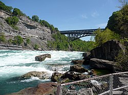
Satellite image of Niagara River flowing north from Lake Erie (bottom) to Lake Ontario (top). The river flows around Grand Island, and then flows over Niagara Falls. It narrows in the Niagara Gorge, where two hydropower reservoirs are visible, and then widens after exiting the gorge. The Welland Canal is visible on the far left.

American Falls with Goat Island to its right
The Niagara River () is a river that flows north from Lake Erie to Lake Ontario. It forms part of the border between the province of Ontario in Canada (on the west) and the state of New York in the United States (on the east). There are differing theories as to the origin of the river’s name. According to Iroquoian scholar Bruce Trigger, Niagara is derived from the name given to a branch of the locally residing native Neutral Confederacy, who are described as being called the Niagagarega people on several late-17th-century French maps of the area.[6] According to George R. Stewart, it comes from the name of an Iroquois town called Ongniaahra, meaning «point of land cut in two».[7]
The river, which is occasionally described as a strait,[8] is about 58 kilometres (36 mi) long and includes Niagara Falls in its course. The falls have moved approximately 11 kilometres (6.8 mi) upstream from the Niagara Escarpment in the last 12,000 years, resulting in a gorge below the falls. Today, the diversion of the river for electrical generation has significantly reduced the rate of erosion. The total drop in elevation along the river is 99 metres (325 ft). The Niagara Gorge extends downstream from the Falls and includes the Niagara Whirlpool and another section of rapids.
Power plants on the river include the Sir Adam Beck Hydroelectric Power Stations (built in 1922 and 1954) on the Canadian side, and the Robert Moses Niagara Power Plant (built in 1961) on the American side. Together, they generate 4.4 gigawatts of electricity. The International Control Works, built in 1954, regulates the river flow. Ships on the Great Lakes use the Welland Canal, part of the Saint Lawrence Seaway, on the Canadian side of the river, to bypass Niagara Falls.
The Niagara River also features two large islands and numerous smaller islands. Grand Island and Navy Island, the two largest islands, are on the American and Canadian sides of the river, respectively. Goat Island and the tiny Luna Island split Niagara Falls into its three sections, the Horseshoe Falls, Bridal Veil Falls, and American Falls. Unity Island lies further upstream, alongside the city of Buffalo.
The Niagara River and its tributaries, Tonawanda Creek and the Welland River, formed part of the last section of the Erie Canal and Welland Canal. After leaving Lockport, New York, the Erie Canal proceeds southwest until it enters Tonawanda Creek. After entering the Niagara River, watercraft then proceed southward to the final lock, where a short section of the canal allows boats to avoid the turbulent shoal water at the river intake and enter Lake Erie. The Welland Canals used the Welland River as a connection to the Niagara River south of the falls, allowing water traffic to safely re-enter the Niagara River and proceed to Lake Erie.
History[edit]

Watercolour by Elizabeth Simcoe depicting the Niagara River from Queenston Heights, c. 1793

Niagara River at Queenston, Ontario, then known as Queenstown, Upper Canada, c. 1805 watercolour
The Niagara River and Falls have been known outside of North America since the late 17th century, when Father Louis Hennepin, a French explorer, first witnessed them. He wrote about his travels in A New Discovery of a Vast Country in America (1698).[9]
The Niagara River was the site of the earliest recorded railway in America. It was an inclined wooden tramway built by John Montresor (1736–1799), a British military engineer, in 1764. Called «The Cradles» and «The Old Lewiston Incline,» it featured loaded carts pulled up wooden rails by rope. It facilitated the movement of goods over the Niagara Escarpment in present-day Lewiston, New York.[10]
In 1781, the Niagara Purchase was signed, involving a 6.5-kilometre-wide (4.0 mi) strip of land bordering the west bank of the Niagara River, connecting Lake Erie and Lake Ontario.[11]
Several battles occurred along the Niagara River, which was historically defended by Fort George (Canadian side) and Fort Niagara (American side) at the mouth of the river and Fort Erie (Canadian side) at the head of the river. These forts were important during the Seven Years’ War (known as the French and Indian War in the United States) and the American Revolutionary War. The Battle of Queenston Heights took place near the river in the War of 1812.
The river was an important route to liberation before the American Civil War, when many African-Americans escaping slavery on the Underground Railroad crossed it to find freedom in Canada. The Freedom Crossing Monument stands on the bank of the river in Lewiston to commemorate the courage of the escaping slaves and the local volunteers who helped them secretly cross the river.
In the 1880s, the Niagara River became the first waterway in North America harnessed for large-scale generation of hydroelectricity.[12]
On the Canadian side of the river the provincial agency Niagara Parks Commission maintains all of the shoreline property, including Fort Erie, except the sites of Fort George (a National Historic Site maintained federally by Parks Canada), as a public greenspace and environmental heritage.
On the American side, the New York State Office of Parks, Recreation and Historic Preservation maintains several state parks adjacent to Niagara Falls and the Niagara River.
Today, the river is the namesake of Niagara Herald Extraordinary at the Canadian Heraldic Authority.
Cities and settlements[edit]


Cities and towns along the Niagara River include:
| Name | Country |
|---|---|
| Buffalo | |
| Chippawa | |
| Fort Erie | |
| Lewiston | |
| Grand Island | |
| Niagara Falls | |
| Niagara Falls | |
| Niagara-on-the-Lake | |
| North Tonawanda | |
| Porter | |
| Queenston | |
| Tonawanda (City) | |
| Tonawanda (Town) | |
| Wheatfield | |
| Youngstown |
Pollution[edit]
The Niagara River is listed as a Great Lakes Areas of Concern in The Great Lakes Water Quality Agreement between the United States and Canada.
Crossings[edit]
The Niagara River has a long history of both road and rail bridges spanning the river, both upstream and downstream of the Falls. This history includes numerous bridges that have fallen victim to the harsh conditions of the Niagara Gorge, such as landslides and icepacks.
Parks[edit]

Niagara Glen features many rapids downstream of Niagara Falls
The following parks are located along the Niagara River:
| Name | Country |
|---|---|
| Beaver Island State Park | |
| Bowen Road Park | |
| Broderick Park | |
| Browns Point Park | |
| Buckhorn Island State Park | |
| De Veaux Woods State Park | |
| Dufferin Islands Natural Area | |
| Earl W. Brydges Artpark State Park | |
| Falkner Park | |
| Fisherman’s Park | |
| Floral Clock Park | |
| Fort George National Historic Site | |
| Fort Niagara State Park | |
| Gratwick Riverside Park | |
| Griffon Park | |
| Jayne Park | |
| Joseph Davis State Park | |
| King’s Bridge Park | |
| MacFarland Park | |
| Niagara Falls State Park | |
| Niagara Glen Nature Reserve | |
| Niagara Parks Botanical Gardens | |
| Niawanda Park[13] | |
| Nike Base Park | |
| Queen’s Parade Park & Memorial Park | |
| Queenston Heights | |
| Riverside Park | |
| Strawberry Island State Park | |
| Sugar Bowl Park | |
| Veterans Memorial Park | |
| Queen Victoria Park | |
| Whirlpool State Park |
A Niagara River Greenway Plan is in progress in the United States.
Hydrologic features[edit]
| Map this section’s coordinates using: OpenStreetMap |
| Download coordinates as: KML |
| Feature | Location | Country | Notes | Photo |
|---|---|---|---|---|
| Source of Niagara River | 42°54′16″N 78°54′21″W / 42.904325°N 78.905869°W | The Niagara River originates at the north-east end of Lake Erie, and flows north to its mouth at Lake Ontario. | 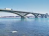
|
|
| Black Rock Canal | 42°54′25″N 78°54′07″W / 42.90706°N 78.902053°W | Black Rock Canal flows within and parallel to the east shore of the Niagara river near Buffalo, New York, and was built to extend the navigation period in the Niagara River through a greater part of the winter.[14] The canal begins at Buffalo Harbor, on the north-east shore of Lake Erie, then flows north, ending at the Black Rock Lock near the north tip of Unity Island. The canal is buffered from the Niagara River by Bird Island Pier at its south end, and Unity Island at its north end. | 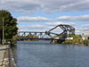
|
|
| Gould Ditch | 42°55′14″N 78°54′42″W / 42.920689°N 78.911785°W | Historic tributary. Once served as a drainage ditch for Gould National Battery plant.[15] | ||
| Scajaquada Creek | 42°55′45″N 78°53′57″W / 42.929091°N 78.899056°W | Tributary. | 
|
|
| Frenchman’s Creek | 42°56′34″N 78°55′39″W / 42.942648°N 78.927391°W | Tributary. | ||
| Chippawa Channel | 42°57′12″N 78°56′15″W / 42.953344°N 78.937626°W | The north-flowing Niagara River bifurcates at the south tip of Grand Island (both sections rejoin at the north tip). «Chippawa Channel» is the river passage on the west side of Grand Island. | ||
| Miller Creek | 42°57′19″N 78°58′31″W / 42.955315°N 78.97537°W | Tributary. | ||
| Tonawanda Channel | 42°57′39″N 78°55′46″W / 42.960757°N 78.929386°W | When the Niagara River bifurcates at Grand Island, the east passage—from the south tip of Grand Island, to a point just north of Tonawanda, New York—is the «Tonawanda Channel». | ||
| Baker Creek | 42°58′22″N 79°00′29″W / 42.972761°N 79.008039°W | Tributary. | ||
| Black Creek | 42°58′52″N 79°01′25″W / 42.980999°N 79.023499°W | Tributary. | ||
| Boyer’s Creek | 43°00′07″N 79°01′46″W / 43.00194°N 79.029508°W | Tributary. | ||
| Two Mile Creek | 43°00′39″N 78°54′24″W / 43.010845°N 78.906555°W | Tributary. | ||
| Little River (at Tonawanda Island) | 43°01′23″N 78°53′06″W / 43.022926°N 78.884969°W | Flows between Tonawanda Island and the New York mainland, within the Tonawanda Channel. | ||
| Tonawanda Creek | 43°01′24″N 78°52′54″W / 43.02338°N 78.881707°W | Tributary. | 
|
|
| Spicer Creek | 43°01′31″N 78°53′39″W / 43.025279°N 78.894153°W | Tributary on Grand Island, New York. | ||
| Big Sixmile Creek | 43°01′35″N 79°00′42″W / 43.026494°N 79.011773°W | Tributary on Grand Island, New York. | ||
| Little Sixmile Creek | 43°01′43″N 79°00′37″W / 43.028502°N 79.010217°W | Tributary on Grand Island, New York. | ||
| Niagara River Channel | 43°02′09″N 78°53′38″W / 43.035772°N 78.893809°W | When the Niagara River bifurcates at Grand Island, the east passage—from a point just north of Tonawanda, New York, to the north tip of Grand Island—is the «Niagara River Channel». | 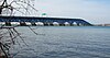
|
|
| Gun Creek | 43°02′58″N 78°54′57″W / 43.049455°N 78.915728°W | Tributary on Grand Island, New York. | ||
| Usshers Creek | 43°03′05″N 79°01′21″W / 43.051282°N 79.022577°W | Tributary. | ||
| Burnt Ship Creek | 43°03′40″N 78°59′51″W / 43.060987°N 78.997493°W | Tributary on Grand Island, New York. | ||
| Woods Creek | 43°03′44″N 78°58′37″W / 43.062335°N 78.976958°W | Tributary on Grand Island, New York. | 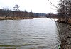
|
|
| Welland River | 43°03′46″N 79°02′53″W / 43.062711°N 79.047961°W | Historic tributary. Became a man-made distributary—from the Niagara River to a point 5 km west—in order to supply water to an intake channel for Sir Adam Beck Hydroelectric Power Stations. | ||
| Underwater intake tunnel to Sir Adam Beck Hydroelectric Power Stations | 43°04′02″N 79°03′14″W / 43.067124°N 79.053959°W | 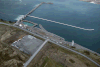
|
||
| Little River (at Cayuga Island) | 43°04′23″N 78°57′06″W / 43.073167°N 78.951724°W | Flows between Cayuga Island and the New York mainland, within the Niagara River Channel. | ||
| Cayuga Creek | 43°04′33″N 78°57′46″W / 43.075894°N 78.962753°W | Tributary. | ||
| Underwater intake for tunnel to Niagara Power Project | 43°04′38″N 79°00′57″W / 43.07725°N 79.015796°W | 
|
||
| Horseshoe Falls | 43°04′38″N 79°04′30″W / 43.077289°N 79.075127°W | Located between the Canadian mainland and Goat Island, New York, the Horseshoe Falls is the largest, and most south-western of three parallel waterfalls over-which the Niagara River flows. There is dispute as to whether the Horseshoe Falls lies entirely within Canada (see Niagara Falls#History). | 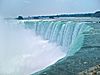
|
|
| Gill Creek | 43°04′42″N 79°01′33″W / 43.078292°N 79.025838°W | Tributary. | ||
| Goat Island Channel | 43°04′50″N 79°03′38″W / 43.080612°N 79.060535°W | The Niagara River bifurcates at the south-east tip of Goat Island. «Goat Island Channel» is the north-east passage around the island. | 
|
|
| Bridal Veil Falls | 43°05′02″N 79°04′15″W / 43.083781°N 79.070776°W | Located between Goat Island and Luna Island, Bridal Veil Falls is the smallest (and middle) of the three parallel waterfalls over-which the Niagara River flows. It is entirely within the US. | 
|
|
| American Falls | 43°05′06″N 79°04′10″W / 43.084866°N 79.069462°W | Located between Luna Island and the New York mainland, the American Falls is the most northern and second largest of three parallel waterfalls over-which the Niagara River flows. It is located entirely within the US. | 
|
|
| Muddy Run Falls | 43°06′54″N 79°03′45″W / 43.114972°N 79.06252°W | Historic tributary which entered the Niagara River as a waterfall from the top of the Niagara Gorge. Development above Muddy Run Falls destroyed its water supply. | ||
| Whirlpool Rapids | 43°06′58″N 79°03′45″W / 43.116006°N 79.062488°W | 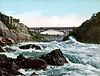
|
||
| Colt’s Creek Falls | 43°07′11″N 79°04′19″W / 43.119757°N 79.071929°W | Tributary which enters the Niagara River as a waterfall from the top of the Niagara Gorge. The volume was greatly diminished following construction of the canal to Sir Adam Beck Hydroelectric Power Stations. | ||
| Niagara Whirlpool | 43°07′13″N 79°04′10″W / 43.120219°N 79.069526°W | The Niagara Whirlpool is a natural whirlpool along the Niagara River located along the Canada–US border between New York and Ontario. The whirlpool is located in the Niagara Gorge, downstream from Niagara Falls. The whirlpool’s greatest depth is 125 feet (38 m).[16] | ||
| Harvie Falls | 43°07′19″N 79°04′28″W / 43.12206°N 79.074311°W | Tributary which enters the Niagara River as a waterfall from the top of the Niagara Gorge. The volume was greatly diminished following construction of the canal to Sir Adam Beck Hydroelectric Power Stations. | ||
| Devil’s Hole Rapids | 43°08′01″N 79°03′03″W / 43.133547°N 79.050901°W | 
|
||
| Bloody Run Falls | 43°08′06″N 79°02′50″W / 43.134987°N 79.047275°W | Tributary which enters the Niagara River as a waterfall from the top of the Niagara Gorge. The volume was greatly diminished following construction of Robert Moses State Parkway and other streets above the falls. | 
|
|
| Niagara Power Project | 43°08′35″N 79°02′23″W / 43.142957°N 79.039807°W | 
|
||
| Sir Adam Beck Hydroelectric Power Stations | 43°08′51″N 79°02′39″W / 43.147419°N 79.04406°W | 
|
||
| Smeaton Falls | 43°09′23″N 79°02′46″W / 43.156275°N 79.045998°W | Tributary which enters the Niagara River as a waterfall from the top of the Niagara Gorge. The volume was greatly diminished following the construction of Sir Adam Beck Hydroelectric Power Stations. | 
|
|
| Spring Cave Cascade | 43°09′26″N 79°02′40″W / 43.157348°N 79.044372°W | Historic tributary which entered the Niagara River as a cascade from caves in the wall of the Niagara Gorge. Its source was destroyed following construction of the Niagara Power Project. | ||
| Fish Creek Falls | 43°09′32″N 79°02′41″W / 43.159018°N 79.04459°W | Tributary which enters the Niagara River as a waterfall from the top of the Niagara Gorge. The volume was greatly diminished following the construction of the Niagara Power Project. | ||
| Locust Grove Falls | 43°09′33″N 79°02′51″W / 43.159183°N 79.047532°W | Tributary which enters the Niagara River as a waterfall from the top of the Niagara Gorge. The volume was greatly diminished following the construction of Sir Adam Beck Hydroelectric Power Stations. | 
|
|
| Mouth of Niagara River | 43°15′46″N 79°04′14″W / 43.262722°N 79.070646°W | 
|
Islands[edit]
Several islands are located on the upper river upriver from the falls:
| Name | Location | Country | Status | Notes |
|---|---|---|---|---|
| Bird Island | Buffalo | Filled in | Connected to Unity Island in 1822 as part of improvements to Black Rock harbor.[17] | |
| Brig Island | Niagara Falls | Park | Part of Niagara Falls State Park. | |
| Brother Island | Niagara Falls | Park | Located near Niagara Falls and the Three Sisters Islands; part of Niagara Falls State Park. | |
| Buckhorn Island | Grand Island | Park | Located on the north end of Grand Island. A state park. | |
| Cayuga Island | Niagara Falls | Residential | Located at the mouth of Cayuga Creek; a residential neighborhood of the city. | |
| Cedar Island | Niagara Falls | Filled in | Filled in by the creation of the Rankine Generating Station by Canadian Niagara Power Company in 1905. | |
| Conners Island | Niagara Falls | Filled in | Also known in some sources as «Coroner Island».[18] Filled in sometime in the 1950s or early ’60s.[19][20] Currently the site of the Niagara Power Station Intake.[21] | |
| Deer Island | Niagara Falls | |||
| Dufferin Islands | Niagara Falls | Park | Man-made islands. Parkland. | |
| Goat Island | Niagara Falls | Park | Located at the brink of the American Falls, named by John Stedman in the 1770s; briefly renamed to Iris Island by General Augustus Porter, a United States Commissioner (after the Greek Goddess of the Rainbow). Now part of Niagara Falls State Park. | |
| Goose Island | City of Tonawanda | Man-made/filled in | Was located at the confluence of Tonawanda Creek and the Tonawanda Channel of the Niagara River. Existed from 1825, when the Erie Canal was constructed (thereby cutting Goose Island off from the mainland) until the 1940s, when this portion of the canal was filled in. | |
| Grand Island | Developed | The largest island on the river; includes several parks, but is mostly residential and industrial; originally called Ga-We-Not (Great Island) by the Seneca. | ||
| Grass Island | Niagara Falls | Filled in | Filled in during the 1960s to create the Robert Moses Parkway at Point Day. | |
| Green Island | Niagara Falls | Park | Originally called Bath Island, it was renamed in the early 1900s for Niagara Reservation Commissioner Andrew H. Green. Part of Niagara Falls State Park. | |
| Gull Island | Niagara Falls | Park | Located near the wreck of the Old Scow in Canadian waters. | |
| Hogg Island | Niagara Falls | Filled in | Filled in by the creation of the Chippawa Queenston Power Canal in 1917 and finally by the Sir Adam Beck Dam #2 in 1950 by the Hydro Electric Power Commission of Ontario. | |
| Little Beaver Island | Grand Island | Park | Located off the south end of Grand Island; part of Beaver Island State Park. | |
| Luna Island | Niagara Falls | Park | Located next to Goat Island; originally called Prospect Island. Part of Niagara Falls State Park. | |
| Motor Island | Grand Island | Park | Also known as Pirates’ Island (the name of a private club once located there) and Frog Island (not to be confused with the former Frog Island listed below).[22] A New York State Wildlife Management Area. | |
| Navy Island | Niagara Falls | Park | Designated as a National Historic Park. | |
| Rattlesnake Island | Town of Tonawanda | Filled in | Was located just south of what is today the South Grand Island Bridge. Was filled in sometime between 1915[23] and 1927,[24] concurrent with the heavy industrial development of the area. | |
| Robinson Island | Niagara Falls | Park | Named for daredevil Joel Robinson in 1860. Now part of Niagara Falls State Park. | |
| Ship Island | Niagara Falls | Park | Part of Niagara Falls State Park. | |
| Stony Island | Niagara Falls | Unknown | Shown in the 1908 New Century Atlas of Niagara and Orleans County but not mentioned in any other source.[21] Supposedly located just offshore from the mouth of Gill Creek.[18] No longer extant, if it ever was. | |
| Strawberry Island | Town of Tonawanda | Park | A small island, formerly much larger but diminished by gravel mining and erosion.[25] An undeveloped state park and wildlife preserve.[26] | |
| Tern Island | Submerged/reconstructed | Originally known as Frog Island; was located in the Upper Niagara River between Motor and Strawberry Islands; disappeared sometime between 1951 and 1985 due to erosion.[27] Re-created as a habitat for fish, aquatic plants, and waterfowl[28][29] including a nesting colony of common terns established in 2021, for whom the new island was named.[30] | ||
| Three Sisters Islands | Niagara Falls | Park | Located next to Goat Island within Niagara Falls State Park. Originally called Moss Islands, they were later renamed for the three daughters of War of 1812 United States Army General Parkhurst Whitney (Asenath, Angeline and Celinda Eliza) in 1843. | |
| Tonawanda Island | North Tonawanda | Developed | Occupied by a marina and several industries. | |
| Tower Island | Niagara Falls | Man-made | Man-made island created in 1942 and completed in 1954 by the US Army Corps of Engineers to construct International Control Dam.[31] | |
| Unity Island | Buffalo | Developed | Home to Broderick Park, Unity Island Park, and a waste-water treatment facility. | |
| Willow Island | Niagara Falls | Man-made/filled in | Man-made island created in 1759 by Daniel Joncairs and filled in during the 1960s to create the Robert Moses Parkway. |
Military posts[edit]
United States Coast Guard Fort Niagara Station was once a United States Army post. There are no Canadian Coast Guard posts along the river. Fort Mississauga, Fort George and Fort Erie are former British and Canadian military forts (last used 1953, 1965 and 1923 respectively) and are now parks.
Navy Island Royal Naval Shipyard was used by the French Navy in the 18th century as a naval base and by the Royal Navy from 1763 as a small shipyard, and abandoned around 1818 after the ratification of the Rush–Bagot Treaty in 1817.
Roads[edit]
On the Canadian side the Niagara Parkway travels along the River from Lake Ontario to Lake Erie.
![]() NY 18F lines the river on the state side from Fort Niagara to Lewiston.
NY 18F lines the river on the state side from Fort Niagara to Lewiston. ![]() Niagara Scenic Parkway on the state side only travels along the River from the Falls to Lewiston. The remaining river sections (with some interruptions) are covered by the
Niagara Scenic Parkway on the state side only travels along the River from the Falls to Lewiston. The remaining river sections (with some interruptions) are covered by the ![]() LaSalle Expressway,
LaSalle Expressway, ![]() NY 384,
NY 384, ![]() NY 266 and
NY 266 and ![]()
![]() I-190 (Niagara Thruway) / New York Thruway.
I-190 (Niagara Thruway) / New York Thruway.
See also[edit]
- List of international border rivers
- List of New York rivers
- List of Ontario rivers
- Whirlpool Aero Car
References[edit]
- ^ Inferred from Lake Erie. Retrieved 2021-01-30.
- ^ Inferred from Lake Ontario. Retrieved 2021-01-30.
- ^ a b «Facts & Figures — Niagara Parks, Niagara Falls, Ontario, Canada». Archived from the original (online) on December 9, 2003. Retrieved May 30, 2007.
- ^ Water Resources Data New York Water Year 2003, Volume 3: Western New York, USGS
- ^ «Niagara River Corridor». Ramsar Sites Information Service. Archived from the original on 14 January 2020. Retrieved 9 January 2020.
- ^ Bruce Trigger, The Children of Aataentsic (McGill-Queen’s University Press, Kingston and Montreal,1987, ISBN 0-7735-0626-8), p. 95.
- ^ Stewart, George R. (1967) Names on the Land. Boston: Houghton Mifflin Company; p. 83.
- ^ Mobot.org
- ^ Hennepin, Louis. A New Discovery of a Vast Country in America. Chicago: A.C. McClurg & Co., 1903. Accessed December 8, 2008.
- ^ Porter, Peter (1914). Landmarks of the Niagara Frontier. The Author.
- ^ «Niagara Purchase | The Canadian Encyclopedia». www.thecanadianencyclopedia.ca. Retrieved 2021-10-13.
- ^ Electricity and its Development at Niagara Falls Archived 2009-01-24 at the Wayback Machine. University at Buffalo, June 2004. Accessed December 8, 2008.
- ^ Google (September 4, 2018). «Niawanda Park» (Map). Google Maps. Google. Retrieved September 4, 2018.
- ^ «Black Rock Canal». Encyclopædia Britannica. Encyclopædia Britannica Online. Retrieved Jan. 3, 2013.
- ^ «Chemicals of Concern in the Niagara River Tributaries — 1988-89». Ontario Ministry of Environment and Energy, Queen’s Printer for Ontario, 1993.
- ^ «Whirlpool State Park — Niagara Falls, New York». Nyfalls.com. 1935-09-13. Archived from the original on 2011-08-23. Retrieved 2011-08-20.
- ^ «Waterways and Canal Construction, 1700-1825. Buffalo, N.Y.» Archived from the original on February 6, 2012.
- ^ a b https://ngmdb.usgs.gov/img4/ht_icons/Browse/NY/NY_Niagara%20Falls_144235_1901_62500.jpg
- ^ https://ngmdb.usgs.gov/img4/ht_icons/Browse/NY/NY_Niagara%20Falls_128711_1949_24000.jpg
- ^ https://ngmdb.usgs.gov/img4/ht_icons/Browse/NY/NY_Niagara%20Falls_128712_1965_24000.jpg
- ^ a b Linnabery, Ann Marie (January 28, 2017). «NIAGARA DISCOVERIES: The lost islands of the Niagara River». Lockport Union-Sun & Journal. Retrieved July 14, 2018.
- ^ Island Dispatch, 16th June 1989
- ^ «Tonawanda Town 8, Riverside Land Company, Atlas: Buffalo 1915 Vol 3 Suburban, New York Historical Map».
- ^ «County Map Atlas No. 8». Archived from the original on October 2, 2006.
- ^ «Strawberry Island — Motor Island Shallows Coastal Fish & Wildlife Habitat Assessment Form» (PDF). NYS Department of State. October 15, 1987. Archived from the original (PDF) on October 16, 2020. Retrieved April 10, 2016.
- ^ «Grand Island: NYPA approves contract for Strawberry Island wetland restoration, habitat improvement». Niagara Frontier Publications. March 30, 2015. Retrieved April 11, 2016.
- ^ http://niagara.nypa.gov/EcologicalStandingCommittee[permanent dead link]
- ^ Pignataro, T.J. (August 22, 2015). «Restoration of Frog Island hailed as Buffalo comeback story». The Buffalo News. Archived from the original on August 23, 2015. Retrieved April 10, 2016.
- ^ «Frog Island Habitat Restoration». October 2013.
- ^ Sotelo, Gabriella (September 2, 2021). «Nesting Common Terns Get a New Island Home in Buffalo». Audubon.
- ^ «Niagara River Islands History — Tower Island, Niagara Falls USA». 3 February 2017. Archived from the original on 2019-10-01. Retrieved 2019-10-01.
- Tiplin, Albert H.; Seibel, George A. and Seibel, Olive M. (1988) Our romantic Niagara: a geological history of the river and the falls Niagara Falls Heritage Foundation, Niagara Falls, Ontario, Canada, ISBN 0-9690457-2-7
Further reading[edit]
- Hulbert, A. B. (1908). The Niagara River. New York: G.P. Putnam’s Sons.
External links[edit]
![]()
- Views of the Niagara River Niagara Falls Public Library (Ontario)
- Digital Images of the Islands of the Niagara River Niagara Falls Public Library (Ontario)
- Buffalo Niagara Riverkeeper
- Niagara Falls The Islands A History of the Niagara River Islands
- «Niagara River» from The Canadian Encyclopedia.
From Wikipedia, the free encyclopedia
| Niagara River
rivière Niagara |
|
|---|---|
|
|
|
|
|
| Location | |
| Countries |
|
| Province / State |
|
| Physical characteristics | |
| Source | Lake Erie |
| • elevation | 173.43 m (569 ft)[1] |
| Mouth | Lake Ontario |
|
• coordinates |
43°04′41″N 79°04′37″W / 43.078°N 79.077°WCoordinates: 43°04′41″N 79°04′37″W / 43.078°N 79.077°W |
|
• elevation |
74.1 m (243 ft)[2] |
| Length | 58 km (36 mi)[3] |
| Basin size | 684,000 km2 (264,000 sq mi)[3] |
| Discharge | |
| • average | 5,796 m3/s (204,700 cu ft/s)[4] |
| Basin features | |
| Progression | Lake Ontario→ Saint Lawrence River→ Gulf of Saint Lawrence |
| Tributaries | |
| • left | Welland River |
| • right | Tonawanda Creek |
|
Ramsar Wetland |
|
| Official name | Niagara River Corridor |
| Designated | 3 October 2019 |
| Reference no. | 2402[5] |
Satellite image of Niagara River flowing north from Lake Erie (bottom) to Lake Ontario (top). The river flows around Grand Island, and then flows over Niagara Falls. It narrows in the Niagara Gorge, where two hydropower reservoirs are visible, and then widens after exiting the gorge. The Welland Canal is visible on the far left.
American Falls with Goat Island to its right
The Niagara River () is a river that flows north from Lake Erie to Lake Ontario. It forms part of the border between the province of Ontario in Canada (on the west) and the state of New York in the United States (on the east). There are differing theories as to the origin of the river’s name. According to Iroquoian scholar Bruce Trigger, Niagara is derived from the name given to a branch of the locally residing native Neutral Confederacy, who are described as being called the Niagagarega people on several late-17th-century French maps of the area.[6] According to George R. Stewart, it comes from the name of an Iroquois town called Ongniaahra, meaning «point of land cut in two».[7]
The river, which is occasionally described as a strait,[8] is about 58 kilometres (36 mi) long and includes Niagara Falls in its course. The falls have moved approximately 11 kilometres (6.8 mi) upstream from the Niagara Escarpment in the last 12,000 years, resulting in a gorge below the falls. Today, the diversion of the river for electrical generation has significantly reduced the rate of erosion. The total drop in elevation along the river is 99 metres (325 ft). The Niagara Gorge extends downstream from the Falls and includes the Niagara Whirlpool and another section of rapids.
Power plants on the river include the Sir Adam Beck Hydroelectric Power Stations (built in 1922 and 1954) on the Canadian side, and the Robert Moses Niagara Power Plant (built in 1961) on the American side. Together, they generate 4.4 gigawatts of electricity. The International Control Works, built in 1954, regulates the river flow. Ships on the Great Lakes use the Welland Canal, part of the Saint Lawrence Seaway, on the Canadian side of the river, to bypass Niagara Falls.
The Niagara River also features two large islands and numerous smaller islands. Grand Island and Navy Island, the two largest islands, are on the American and Canadian sides of the river, respectively. Goat Island and the tiny Luna Island split Niagara Falls into its three sections, the Horseshoe Falls, Bridal Veil Falls, and American Falls. Unity Island lies further upstream, alongside the city of Buffalo.
The Niagara River and its tributaries, Tonawanda Creek and the Welland River, formed part of the last section of the Erie Canal and Welland Canal. After leaving Lockport, New York, the Erie Canal proceeds southwest until it enters Tonawanda Creek. After entering the Niagara River, watercraft then proceed southward to the final lock, where a short section of the canal allows boats to avoid the turbulent shoal water at the river intake and enter Lake Erie. The Welland Canals used the Welland River as a connection to the Niagara River south of the falls, allowing water traffic to safely re-enter the Niagara River and proceed to Lake Erie.
History[edit]
Watercolour by Elizabeth Simcoe depicting the Niagara River from Queenston Heights, c. 1793
Niagara River at Queenston, Ontario, then known as Queenstown, Upper Canada, c. 1805 watercolour
The Niagara River and Falls have been known outside of North America since the late 17th century, when Father Louis Hennepin, a French explorer, first witnessed them. He wrote about his travels in A New Discovery of a Vast Country in America (1698).[9]
The Niagara River was the site of the earliest recorded railway in America. It was an inclined wooden tramway built by John Montresor (1736–1799), a British military engineer, in 1764. Called «The Cradles» and «The Old Lewiston Incline,» it featured loaded carts pulled up wooden rails by rope. It facilitated the movement of goods over the Niagara Escarpment in present-day Lewiston, New York.[10]
In 1781, the Niagara Purchase was signed, involving a 6.5-kilometre-wide (4.0 mi) strip of land bordering the west bank of the Niagara River, connecting Lake Erie and Lake Ontario.[11]
Several battles occurred along the Niagara River, which was historically defended by Fort George (Canadian side) and Fort Niagara (American side) at the mouth of the river and Fort Erie (Canadian side) at the head of the river. These forts were important during the Seven Years’ War (known as the French and Indian War in the United States) and the American Revolutionary War. The Battle of Queenston Heights took place near the river in the War of 1812.
The river was an important route to liberation before the American Civil War, when many African-Americans escaping slavery on the Underground Railroad crossed it to find freedom in Canada. The Freedom Crossing Monument stands on the bank of the river in Lewiston to commemorate the courage of the escaping slaves and the local volunteers who helped them secretly cross the river.
In the 1880s, the Niagara River became the first waterway in North America harnessed for large-scale generation of hydroelectricity.[12]
On the Canadian side of the river the provincial agency Niagara Parks Commission maintains all of the shoreline property, including Fort Erie, except the sites of Fort George (a National Historic Site maintained federally by Parks Canada), as a public greenspace and environmental heritage.
On the American side, the New York State Office of Parks, Recreation and Historic Preservation maintains several state parks adjacent to Niagara Falls and the Niagara River.
Today, the river is the namesake of Niagara Herald Extraordinary at the Canadian Heraldic Authority.
Cities and settlements[edit]
Cities and towns along the Niagara River include:
| Name | Country |
|---|---|
| Buffalo | |
| Chippawa | |
| Fort Erie | |
| Lewiston | |
| Grand Island | |
| Niagara Falls | |
| Niagara Falls | |
| Niagara-on-the-Lake | |
| North Tonawanda | |
| Porter | |
| Queenston | |
| Tonawanda (City) | |
| Tonawanda (Town) | |
| Wheatfield | |
| Youngstown |
Pollution[edit]
The Niagara River is listed as a Great Lakes Areas of Concern in The Great Lakes Water Quality Agreement between the United States and Canada.
Crossings[edit]
The Niagara River has a long history of both road and rail bridges spanning the river, both upstream and downstream of the Falls. This history includes numerous bridges that have fallen victim to the harsh conditions of the Niagara Gorge, such as landslides and icepacks.
Parks[edit]
Niagara Glen features many rapids downstream of Niagara Falls
The following parks are located along the Niagara River:
| Name | Country |
|---|---|
| Beaver Island State Park | |
| Bowen Road Park | |
| Broderick Park | |
| Browns Point Park | |
| Buckhorn Island State Park | |
| De Veaux Woods State Park | |
| Dufferin Islands Natural Area | |
| Earl W. Brydges Artpark State Park | |
| Falkner Park | |
| Fisherman’s Park | |
| Floral Clock Park | |
| Fort George National Historic Site | |
| Fort Niagara State Park | |
| Gratwick Riverside Park | |
| Griffon Park | |
| Jayne Park | |
| Joseph Davis State Park | |
| King’s Bridge Park | |
| MacFarland Park | |
| Niagara Falls State Park | |
| Niagara Glen Nature Reserve | |
| Niagara Parks Botanical Gardens | |
| Niawanda Park[13] | |
| Nike Base Park | |
| Queen’s Parade Park & Memorial Park | |
| Queenston Heights | |
| Riverside Park | |
| Strawberry Island State Park | |
| Sugar Bowl Park | |
| Veterans Memorial Park | |
| Queen Victoria Park | |
| Whirlpool State Park |
A Niagara River Greenway Plan is in progress in the United States.
Hydrologic features[edit]
| Map this section’s coordinates using: OpenStreetMap |
| Download coordinates as: KML |
| Feature | Location | Country | Notes | Photo |
|---|---|---|---|---|
| Source of Niagara River | 42°54′16″N 78°54′21″W / 42.904325°N 78.905869°W | The Niagara River originates at the north-east end of Lake Erie, and flows north to its mouth at Lake Ontario. |
|
|
| Black Rock Canal | 42°54′25″N 78°54′07″W / 42.90706°N 78.902053°W | Black Rock Canal flows within and parallel to the east shore of the Niagara river near Buffalo, New York, and was built to extend the navigation period in the Niagara River through a greater part of the winter.[14] The canal begins at Buffalo Harbor, on the north-east shore of Lake Erie, then flows north, ending at the Black Rock Lock near the north tip of Unity Island. The canal is buffered from the Niagara River by Bird Island Pier at its south end, and Unity Island at its north end. |
|
|
| Gould Ditch | 42°55′14″N 78°54′42″W / 42.920689°N 78.911785°W | Historic tributary. Once served as a drainage ditch for Gould National Battery plant.[15] | ||
| Scajaquada Creek | 42°55′45″N 78°53′57″W / 42.929091°N 78.899056°W | Tributary. |
|
|
| Frenchman’s Creek | 42°56′34″N 78°55′39″W / 42.942648°N 78.927391°W | Tributary. | ||
| Chippawa Channel | 42°57′12″N 78°56′15″W / 42.953344°N 78.937626°W | The north-flowing Niagara River bifurcates at the south tip of Grand Island (both sections rejoin at the north tip). «Chippawa Channel» is the river passage on the west side of Grand Island. | ||
| Miller Creek | 42°57′19″N 78°58′31″W / 42.955315°N 78.97537°W | Tributary. | ||
| Tonawanda Channel | 42°57′39″N 78°55′46″W / 42.960757°N 78.929386°W | When the Niagara River bifurcates at Grand Island, the east passage—from the south tip of Grand Island, to a point just north of Tonawanda, New York—is the «Tonawanda Channel». | ||
| Baker Creek | 42°58′22″N 79°00′29″W / 42.972761°N 79.008039°W | Tributary. | ||
| Black Creek | 42°58′52″N 79°01′25″W / 42.980999°N 79.023499°W | Tributary. | ||
| Boyer’s Creek | 43°00′07″N 79°01′46″W / 43.00194°N 79.029508°W | Tributary. | ||
| Two Mile Creek | 43°00′39″N 78°54′24″W / 43.010845°N 78.906555°W | Tributary. | ||
| Little River (at Tonawanda Island) | 43°01′23″N 78°53′06″W / 43.022926°N 78.884969°W | Flows between Tonawanda Island and the New York mainland, within the Tonawanda Channel. | ||
| Tonawanda Creek | 43°01′24″N 78°52′54″W / 43.02338°N 78.881707°W | Tributary. |
|
|
| Spicer Creek | 43°01′31″N 78°53′39″W / 43.025279°N 78.894153°W | Tributary on Grand Island, New York. | ||
| Big Sixmile Creek | 43°01′35″N 79°00′42″W / 43.026494°N 79.011773°W | Tributary on Grand Island, New York. | ||
| Little Sixmile Creek | 43°01′43″N 79°00′37″W / 43.028502°N 79.010217°W | Tributary on Grand Island, New York. | ||
| Niagara River Channel | 43°02′09″N 78°53′38″W / 43.035772°N 78.893809°W | When the Niagara River bifurcates at Grand Island, the east passage—from a point just north of Tonawanda, New York, to the north tip of Grand Island—is the «Niagara River Channel». |
|
|
| Gun Creek | 43°02′58″N 78°54′57″W / 43.049455°N 78.915728°W | Tributary on Grand Island, New York. | ||
| Usshers Creek | 43°03′05″N 79°01′21″W / 43.051282°N 79.022577°W | Tributary. | ||
| Burnt Ship Creek | 43°03′40″N 78°59′51″W / 43.060987°N 78.997493°W | Tributary on Grand Island, New York. | ||
| Woods Creek | 43°03′44″N 78°58′37″W / 43.062335°N 78.976958°W | Tributary on Grand Island, New York. |
|
|
| Welland River | 43°03′46″N 79°02′53″W / 43.062711°N 79.047961°W | Historic tributary. Became a man-made distributary—from the Niagara River to a point 5 km west—in order to supply water to an intake channel for Sir Adam Beck Hydroelectric Power Stations. | ||
| Underwater intake tunnel to Sir Adam Beck Hydroelectric Power Stations | 43°04′02″N 79°03′14″W / 43.067124°N 79.053959°W |
|
||
| Little River (at Cayuga Island) | 43°04′23″N 78°57′06″W / 43.073167°N 78.951724°W | Flows between Cayuga Island and the New York mainland, within the Niagara River Channel. | ||
| Cayuga Creek | 43°04′33″N 78°57′46″W / 43.075894°N 78.962753°W | Tributary. | ||
| Underwater intake for tunnel to Niagara Power Project | 43°04′38″N 79°00′57″W / 43.07725°N 79.015796°W |
|
||
| Horseshoe Falls | 43°04′38″N 79°04′30″W / 43.077289°N 79.075127°W | Located between the Canadian mainland and Goat Island, New York, the Horseshoe Falls is the largest, and most south-western of three parallel waterfalls over-which the Niagara River flows. There is dispute as to whether the Horseshoe Falls lies entirely within Canada (see Niagara Falls#History). |
|
|
| Gill Creek | 43°04′42″N 79°01′33″W / 43.078292°N 79.025838°W | Tributary. | ||
| Goat Island Channel | 43°04′50″N 79°03′38″W / 43.080612°N 79.060535°W | The Niagara River bifurcates at the south-east tip of Goat Island. «Goat Island Channel» is the north-east passage around the island. |
|
|
| Bridal Veil Falls | 43°05′02″N 79°04′15″W / 43.083781°N 79.070776°W | Located between Goat Island and Luna Island, Bridal Veil Falls is the smallest (and middle) of the three parallel waterfalls over-which the Niagara River flows. It is entirely within the US. |
|
|
| American Falls | 43°05′06″N 79°04′10″W / 43.084866°N 79.069462°W | Located between Luna Island and the New York mainland, the American Falls is the most northern and second largest of three parallel waterfalls over-which the Niagara River flows. It is located entirely within the US. |
|
|
| Muddy Run Falls | 43°06′54″N 79°03′45″W / 43.114972°N 79.06252°W | Historic tributary which entered the Niagara River as a waterfall from the top of the Niagara Gorge. Development above Muddy Run Falls destroyed its water supply. | ||
| Whirlpool Rapids | 43°06′58″N 79°03′45″W / 43.116006°N 79.062488°W |
|
||
| Colt’s Creek Falls | 43°07′11″N 79°04′19″W / 43.119757°N 79.071929°W | Tributary which enters the Niagara River as a waterfall from the top of the Niagara Gorge. The volume was greatly diminished following construction of the canal to Sir Adam Beck Hydroelectric Power Stations. | ||
| Niagara Whirlpool | 43°07′13″N 79°04′10″W / 43.120219°N 79.069526°W | The Niagara Whirlpool is a natural whirlpool along the Niagara River located along the Canada–US border between New York and Ontario. The whirlpool is located in the Niagara Gorge, downstream from Niagara Falls. The whirlpool’s greatest depth is 125 feet (38 m).[16] | ||
| Harvie Falls | 43°07′19″N 79°04′28″W / 43.12206°N 79.074311°W | Tributary which enters the Niagara River as a waterfall from the top of the Niagara Gorge. The volume was greatly diminished following construction of the canal to Sir Adam Beck Hydroelectric Power Stations. | ||
| Devil’s Hole Rapids | 43°08′01″N 79°03′03″W / 43.133547°N 79.050901°W |
|
||
| Bloody Run Falls | 43°08′06″N 79°02′50″W / 43.134987°N 79.047275°W | Tributary which enters the Niagara River as a waterfall from the top of the Niagara Gorge. The volume was greatly diminished following construction of Robert Moses State Parkway and other streets above the falls. |
|
|
| Niagara Power Project | 43°08′35″N 79°02′23″W / 43.142957°N 79.039807°W |
|
||
| Sir Adam Beck Hydroelectric Power Stations | 43°08′51″N 79°02′39″W / 43.147419°N 79.04406°W |
|
||
| Smeaton Falls | 43°09′23″N 79°02′46″W / 43.156275°N 79.045998°W | Tributary which enters the Niagara River as a waterfall from the top of the Niagara Gorge. The volume was greatly diminished following the construction of Sir Adam Beck Hydroelectric Power Stations. |
|
|
| Spring Cave Cascade | 43°09′26″N 79°02′40″W / 43.157348°N 79.044372°W | Historic tributary which entered the Niagara River as a cascade from caves in the wall of the Niagara Gorge. Its source was destroyed following construction of the Niagara Power Project. | ||
| Fish Creek Falls | 43°09′32″N 79°02′41″W / 43.159018°N 79.04459°W | Tributary which enters the Niagara River as a waterfall from the top of the Niagara Gorge. The volume was greatly diminished following the construction of the Niagara Power Project. | ||
| Locust Grove Falls | 43°09′33″N 79°02′51″W / 43.159183°N 79.047532°W | Tributary which enters the Niagara River as a waterfall from the top of the Niagara Gorge. The volume was greatly diminished following the construction of Sir Adam Beck Hydroelectric Power Stations. |
|
|
| Mouth of Niagara River | 43°15′46″N 79°04′14″W / 43.262722°N 79.070646°W |
|
Islands[edit]
Several islands are located on the upper river upriver from the falls:
| Name | Location | Country | Status | Notes |
|---|---|---|---|---|
| Bird Island | Buffalo | Filled in | Connected to Unity Island in 1822 as part of improvements to Black Rock harbor.[17] | |
| Brig Island | Niagara Falls | Park | Part of Niagara Falls State Park. | |
| Brother Island | Niagara Falls | Park | Located near Niagara Falls and the Three Sisters Islands; part of Niagara Falls State Park. | |
| Buckhorn Island | Grand Island | Park | Located on the north end of Grand Island. A state park. | |
| Cayuga Island | Niagara Falls | Residential | Located at the mouth of Cayuga Creek; a residential neighborhood of the city. | |
| Cedar Island | Niagara Falls | Filled in | Filled in by the creation of the Rankine Generating Station by Canadian Niagara Power Company in 1905. | |
| Conners Island | Niagara Falls | Filled in | Also known in some sources as «Coroner Island».[18] Filled in sometime in the 1950s or early ’60s.[19][20] Currently the site of the Niagara Power Station Intake.[21] | |
| Deer Island | Niagara Falls | |||
| Dufferin Islands | Niagara Falls | Park | Man-made islands. Parkland. | |
| Goat Island | Niagara Falls | Park | Located at the brink of the American Falls, named by John Stedman in the 1770s; briefly renamed to Iris Island by General Augustus Porter, a United States Commissioner (after the Greek Goddess of the Rainbow). Now part of Niagara Falls State Park. | |
| Goose Island | City of Tonawanda | Man-made/filled in | Was located at the confluence of Tonawanda Creek and the Tonawanda Channel of the Niagara River. Existed from 1825, when the Erie Canal was constructed (thereby cutting Goose Island off from the mainland) until the 1940s, when this portion of the canal was filled in. | |
| Grand Island | Developed | The largest island on the river; includes several parks, but is mostly residential and industrial; originally called Ga-We-Not (Great Island) by the Seneca. | ||
| Grass Island | Niagara Falls | Filled in | Filled in during the 1960s to create the Robert Moses Parkway at Point Day. | |
| Green Island | Niagara Falls | Park | Originally called Bath Island, it was renamed in the early 1900s for Niagara Reservation Commissioner Andrew H. Green. Part of Niagara Falls State Park. | |
| Gull Island | Niagara Falls | Park | Located near the wreck of the Old Scow in Canadian waters. | |
| Hogg Island | Niagara Falls | Filled in | Filled in by the creation of the Chippawa Queenston Power Canal in 1917 and finally by the Sir Adam Beck Dam #2 in 1950 by the Hydro Electric Power Commission of Ontario. | |
| Little Beaver Island | Grand Island | Park | Located off the south end of Grand Island; part of Beaver Island State Park. | |
| Luna Island | Niagara Falls | Park | Located next to Goat Island; originally called Prospect Island. Part of Niagara Falls State Park. | |
| Motor Island | Grand Island | Park | Also known as Pirates’ Island (the name of a private club once located there) and Frog Island (not to be confused with the former Frog Island listed below).[22] A New York State Wildlife Management Area. | |
| Navy Island | Niagara Falls | Park | Designated as a National Historic Park. | |
| Rattlesnake Island | Town of Tonawanda | Filled in | Was located just south of what is today the South Grand Island Bridge. Was filled in sometime between 1915[23] and 1927,[24] concurrent with the heavy industrial development of the area. | |
| Robinson Island | Niagara Falls | Park | Named for daredevil Joel Robinson in 1860. Now part of Niagara Falls State Park. | |
| Ship Island | Niagara Falls | Park | Part of Niagara Falls State Park. | |
| Stony Island | Niagara Falls | Unknown | Shown in the 1908 New Century Atlas of Niagara and Orleans County but not mentioned in any other source.[21] Supposedly located just offshore from the mouth of Gill Creek.[18] No longer extant, if it ever was. | |
| Strawberry Island | Town of Tonawanda | Park | A small island, formerly much larger but diminished by gravel mining and erosion.[25] An undeveloped state park and wildlife preserve.[26] | |
| Tern Island | Submerged/reconstructed | Originally known as Frog Island; was located in the Upper Niagara River between Motor and Strawberry Islands; disappeared sometime between 1951 and 1985 due to erosion.[27] Re-created as a habitat for fish, aquatic plants, and waterfowl[28][29] including a nesting colony of common terns established in 2021, for whom the new island was named.[30] | ||
| Three Sisters Islands | Niagara Falls | Park | Located next to Goat Island within Niagara Falls State Park. Originally called Moss Islands, they were later renamed for the three daughters of War of 1812 United States Army General Parkhurst Whitney (Asenath, Angeline and Celinda Eliza) in 1843. | |
| Tonawanda Island | North Tonawanda | Developed | Occupied by a marina and several industries. | |
| Tower Island | Niagara Falls | Man-made | Man-made island created in 1942 and completed in 1954 by the US Army Corps of Engineers to construct International Control Dam.[31] | |
| Unity Island | Buffalo | Developed | Home to Broderick Park, Unity Island Park, and a waste-water treatment facility. | |
| Willow Island | Niagara Falls | Man-made/filled in | Man-made island created in 1759 by Daniel Joncairs and filled in during the 1960s to create the Robert Moses Parkway. |
Military posts[edit]
United States Coast Guard Fort Niagara Station was once a United States Army post. There are no Canadian Coast Guard posts along the river. Fort Mississauga, Fort George and Fort Erie are former British and Canadian military forts (last used 1953, 1965 and 1923 respectively) and are now parks.
Navy Island Royal Naval Shipyard was used by the French Navy in the 18th century as a naval base and by the Royal Navy from 1763 as a small shipyard, and abandoned around 1818 after the ratification of the Rush–Bagot Treaty in 1817.
Roads[edit]
On the Canadian side the Niagara Parkway travels along the River from Lake Ontario to Lake Erie.
![]() NY 18F lines the river on the state side from Fort Niagara to Lewiston.
NY 18F lines the river on the state side from Fort Niagara to Lewiston. ![]() Niagara Scenic Parkway on the state side only travels along the River from the Falls to Lewiston. The remaining river sections (with some interruptions) are covered by the
Niagara Scenic Parkway on the state side only travels along the River from the Falls to Lewiston. The remaining river sections (with some interruptions) are covered by the ![]() LaSalle Expressway,
LaSalle Expressway, ![]() NY 384,
NY 384, ![]() NY 266 and
NY 266 and ![]()
![]() I-190 (Niagara Thruway) / New York Thruway.
I-190 (Niagara Thruway) / New York Thruway.
See also[edit]
- List of international border rivers
- List of New York rivers
- List of Ontario rivers
- Whirlpool Aero Car
References[edit]
- ^ Inferred from Lake Erie. Retrieved 2021-01-30.
- ^ Inferred from Lake Ontario. Retrieved 2021-01-30.
- ^ a b «Facts & Figures — Niagara Parks, Niagara Falls, Ontario, Canada». Archived from the original (online) on December 9, 2003. Retrieved May 30, 2007.
- ^ Water Resources Data New York Water Year 2003, Volume 3: Western New York, USGS
- ^ «Niagara River Corridor». Ramsar Sites Information Service. Archived from the original on 14 January 2020. Retrieved 9 January 2020.
- ^ Bruce Trigger, The Children of Aataentsic (McGill-Queen’s University Press, Kingston and Montreal,1987, ISBN 0-7735-0626-8), p. 95.
- ^ Stewart, George R. (1967) Names on the Land. Boston: Houghton Mifflin Company; p. 83.
- ^ Mobot.org
- ^ Hennepin, Louis. A New Discovery of a Vast Country in America. Chicago: A.C. McClurg & Co., 1903. Accessed December 8, 2008.
- ^ Porter, Peter (1914). Landmarks of the Niagara Frontier. The Author.
- ^ «Niagara Purchase | The Canadian Encyclopedia». www.thecanadianencyclopedia.ca. Retrieved 2021-10-13.
- ^ Electricity and its Development at Niagara Falls Archived 2009-01-24 at the Wayback Machine. University at Buffalo, June 2004. Accessed December 8, 2008.
- ^ Google (September 4, 2018). «Niawanda Park» (Map). Google Maps. Google. Retrieved September 4, 2018.
- ^ «Black Rock Canal». Encyclopædia Britannica. Encyclopædia Britannica Online. Retrieved Jan. 3, 2013.
- ^ «Chemicals of Concern in the Niagara River Tributaries — 1988-89». Ontario Ministry of Environment and Energy, Queen’s Printer for Ontario, 1993.
- ^ «Whirlpool State Park — Niagara Falls, New York». Nyfalls.com. 1935-09-13. Archived from the original on 2011-08-23. Retrieved 2011-08-20.
- ^ «Waterways and Canal Construction, 1700-1825. Buffalo, N.Y.» Archived from the original on February 6, 2012.
- ^ a b https://ngmdb.usgs.gov/img4/ht_icons/Browse/NY/NY_Niagara%20Falls_144235_1901_62500.jpg
- ^ https://ngmdb.usgs.gov/img4/ht_icons/Browse/NY/NY_Niagara%20Falls_128711_1949_24000.jpg
- ^ https://ngmdb.usgs.gov/img4/ht_icons/Browse/NY/NY_Niagara%20Falls_128712_1965_24000.jpg
- ^ a b Linnabery, Ann Marie (January 28, 2017). «NIAGARA DISCOVERIES: The lost islands of the Niagara River». Lockport Union-Sun & Journal. Retrieved July 14, 2018.
- ^ Island Dispatch, 16th June 1989
- ^ «Tonawanda Town 8, Riverside Land Company, Atlas: Buffalo 1915 Vol 3 Suburban, New York Historical Map».
- ^ «County Map Atlas No. 8». Archived from the original on October 2, 2006.
- ^ «Strawberry Island — Motor Island Shallows Coastal Fish & Wildlife Habitat Assessment Form» (PDF). NYS Department of State. October 15, 1987. Archived from the original (PDF) on October 16, 2020. Retrieved April 10, 2016.
- ^ «Grand Island: NYPA approves contract for Strawberry Island wetland restoration, habitat improvement». Niagara Frontier Publications. March 30, 2015. Retrieved April 11, 2016.
- ^ http://niagara.nypa.gov/EcologicalStandingCommittee[permanent dead link]
- ^ Pignataro, T.J. (August 22, 2015). «Restoration of Frog Island hailed as Buffalo comeback story». The Buffalo News. Archived from the original on August 23, 2015. Retrieved April 10, 2016.
- ^ «Frog Island Habitat Restoration». October 2013.
- ^ Sotelo, Gabriella (September 2, 2021). «Nesting Common Terns Get a New Island Home in Buffalo». Audubon.
- ^ «Niagara River Islands History — Tower Island, Niagara Falls USA». 3 February 2017. Archived from the original on 2019-10-01. Retrieved 2019-10-01.
- Tiplin, Albert H.; Seibel, George A. and Seibel, Olive M. (1988) Our romantic Niagara: a geological history of the river and the falls Niagara Falls Heritage Foundation, Niagara Falls, Ontario, Canada, ISBN 0-9690457-2-7
Further reading[edit]
- Hulbert, A. B. (1908). The Niagara River. New York: G.P. Putnam’s Sons.
External links[edit]
![]()
- Views of the Niagara River Niagara Falls Public Library (Ontario)
- Digital Images of the Islands of the Niagara River Niagara Falls Public Library (Ontario)
- Buffalo Niagara Riverkeeper
- Niagara Falls The Islands A History of the Niagara River Islands
- «Niagara River» from The Canadian Encyclopedia.
Что такое «ниагара»? Значение слова в словарях и простыми словами, примеры употребления в тексте
Cлово НИАГАРА означает:
(Niagara) — река в Сев. Америке, пограничная между США и Канадой.54 км, площадь бассейна 665 тыс. км2. Вытекает из оз. Эри, впадает в оз.Онтарио. Средний расход 5,9 тыс. м3/с. Образует Ниагарский водопад, вобход которого сооружен канал Уэлленд.
Источник: Большой Энциклопедический Словарь
ниагара
Ниагара
Ниага́ра — река в Северной Америке, соединяющая между собой озёра Эри и Онтарио и отделяющая штат Нью-Йорк (США) от канадской провинции Онтарио. Длина около 56 км, площадь бассейна 665 тысяч км².
Источник: Википедия
ниагара
(Niagara) , река в Сев. Америке, пограничная между США и Канадой. 54 км, площадь бассейна 665 тыс. км
2. Вытекает из оз. Эри, впадает в оз. Онтарио. Средний расход 5,9 тыс. м3/с. Образует Ниагарский водопад, в обход которого сооружен канал Уэлленд.
Источник: Современный толковый словарь, БСЭ
ниагара
(Niagara), река в Северной Америке, служит границей между США и Канадой. Длина 54 км, площадь бассейна 665 тыс. км
2. Вытекает из озера Эри, впадает в озеро Онтарио. В верхнем течении разветвляется на два рукава, между которыми — о. Гранд-Айленд. В среднем течении находятся Ниагарский водопад и пороги, в обход которых сооружен канал Уэлленд. Средний годовой расход воды 5,9 тыс. м3/сек, колебания расхода от 2,8 тыс. м3/сек до 7,7 тыс. м3/сек. На Н. — гг. Буффало (в истоке) и Ниагара-Фоле.
Источник: Большая советская энциклопедия, БСЭ
Морфемный разбор слова«ниагара»
Морфемный (разбор по составу, частям речи) разбор слова ниагара. Слоги, перенос слова, транскрипция и цветовая схема.
- Разбор по составу слова НИАГАРА
Синонимы к слову «ниагара»
Какими словами можно заменить слово ниагара? В качестве синонимов в русском языке чаще всего используются:
- Река
Все синонимы к слову НИАГАРА
Предложения со словом «ниагара»
Примеры употребления слова ниагара в классической литературе, цитаты из популярных фильмов и сериалов.
Так и хочется спросить у ненавистников легендарного наркома, кто из них выдаст на-гора ещё более тяжелогруженую цифровую вагонетку?
Акакий Васадзе, Человек из стали. Иосиф Джугашвили
Спустя год, как правило, заканчивался первых цикл строительства, и новоявленная колония начинала окупать себя, выдавая на-гора партии обогащённых полезных ископаемых.
Андрей Ливадный, Заря над Араксом
Страна как бы выдавала на-гора настоящих героев.
Константин Евграфов, Николай Крючков. Русский характер
Все предложения и цитаты со словом НИАГАРА
Cлово «ниагара» является ответом на вопросы
- Ночью 29 марта 1848 года жители этого городка проснулись от необычайной тишины, а как называется этот городок? 7 букв
- Река, «упавшая» из Канады в Америку
- Падает из Канады в США
- Кино с Мэрилин Монро
- Река с большим водопадом
- Самый знаменитый водопад
- Фильм с водопадом и Монро
- Ода кубинского поэта Хосе Мария Эредиа
- Канадско-американская река
- Река известного водопада
Ниагара
- Ниагара
- Ниага́ра
(Niagara), река в Северной Америке, пограничная между США и Канадой. 54 км, площадь бассейна 665 тыс. км2. Вытекает из оз. Эри, впадает в оз. Онтарио. Средний расход 5,9 тыс. м3/с. Образует Ниагарский водопад, в обход которого сооружён канал Уэлленд.
* * *
НИАГАРА
НИАГА́РА (Niagara), река в Северной Америке, пограничная между США (см. США) и Канадой (см. КАНАДА (государство)). Протяженность 54 км, площадь бассейна 665 тыс. км2. Вытекает из озера Эри (см. ЭРИ (озеро)), впадает в озеро Онтарио (см. ОНТАРИО (озеро)). Средний расход 5,9 тыс. м3/с. На обоих берегах небольшие города с одинаковым названием Ниагара-Фолс (один в США (см. НИАГАРА-ФОЛС (город в США)), другой в Канаде (см. НИАГАРА-ФОЛС (город в Канаде))). Образует Ниагарский водопад (см. НИАГАРСКИЙ ВОДОПАД), в обход которого сооружен канал Уэлленд.
Энциклопедический словарь.
2009.
Синонимы:
Смотреть что такое «Ниагара» в других словарях:
-
Ниагара — река, соединяет озера Эри и Онтарио; на границе США и Канады. На языке ирокезов, живших между озерами Эри и Онтарио, река называлась Онгниара или Онгиара, что означало земля надвое , земля пополам , по видимому, короткая и бурная река, имеющая… … Географическая энциклопедия
-
НИАГАРА — «НИАГАРА», Украина, киностудия ИМ. А.ДОВЖЕНКО, 1991, цв., 96 мин. Трагикомедия. Натурщица, умело скрывающая свою неустроенность, одиночество и надежду на любовь за бравадой и куражом, не может поверить в счастье, которое пришло к ней в лице… … Энциклопедия кино
-
ниагара — сущ., кол во синонимов: 4 • небесный (31) • река (2073) • сизый (10) • … Словарь синонимов
-
ниагара — Серия силура в штатах Нью Йорк, Мичиган, Огайо, Висконсин и Иллинойс [http://slovarionline.ru/anglo russkiy slovar neftegazovoy promyishlennosti/] Тематики нефтегазовая промышленность EN Niagara … Справочник технического переводчика
-
Ниагара — У этого термина существуют и другие значения, см. Ниагара (значения). Ниагара Niagara River Карта Ниагары … Википедия
-
Ниагара — (Niagara) река в Северной Америке, служит границей между США и Канадой. Длина 54 км, площадь бассейна 665 тыс. км2. Вытекает из озера Эри, впадает в озеро Онтарио. В верхнем течении разветвляется на два рукава, между которыми о. Гранд… … Большая советская энциклопедия
-
Ниагара-он-те-Лейк — Niagara on the Lake Расположение Ниагара он те Лейка в районе Ниагара … Википедия
-
Ниагара (фильм, 1953) — Ниагара Niagara Жанр Триллер … Википедия
-
Ниагара (значения) — Ниагара, Niagara (от слов на языках индейского племени Мохоки ohnyákara перешеек (между озерами)[1] или народа Нейтраль onghiar[2] /on ge ara/ гром воды[3]) историческое название Ниагарского водопада, от которого происходят… … Википедия
-
Ниагара (река) — Ниагара Niagara River Карта Ниагары с выделенным островом Нейви Айленд. Исток Озеро Эри Устье Озеро Онтарио … Википедия
ниага́ра
Ниагара — слово из 4 слогов: ни-а-га-ра. Ударение падает на 3-й слог.
Транскрипция слова: [н’иагара]
н — [н’] — согласный, звонкий непарный, сонорный (всегда звонкий), мягкий (парный)
и — [и] — гласный, безударный
а — [а] — гласный, безударный
г — [г] — согласный, звонкий парный, твёрдый (парный)
а — [а] — гласный, ударный
р — [р] — согласный, звонкий непарный, сонорный (всегда звонкий), твёрдый (парный)
а — [а] — гласный, безударный
В слове 7 букв и 7 звуков.
Цветовая схема: ниагара