![]()
Загрузить PDF
![]()
Загрузить PDF
Широта и долгота — координаты на земном шаре, которые помогут вам найти определенное место. При написании широты и долготы стоит убедиться, что вы используете правильный формат и правильные символы, чтобы вас поняли. Можно определить положение различных точек широты и долготы на карте, а затем записать их. Можно записать широту и долготу, используя только значение параллели и меридиана. Для конкретных точек широты и долготы можно записать координаты с помощью градусов, минут, секунд и десятичных дробей.
-

1
Определите географическую долготу. Меридиан — линия долготы, идущая вертикально по всему шару, от Северного до Южного полюса. Нулевой (начальный) меридиан является точкой отсчета долготы. Это нулевая отметка. Еще она называется Гринвичским меридианом. При записи долготы используется символ ° для обозначения градусов.[1]
- Меридианы отсчитываются на восток и на запад от нулевого. При движении на восток величина географической долготы увеличивается на один градус для каждого последующего меридиана. Можно использовать сокращение «в. д.» («восточной долготы»; для международного обозначения используется буква «E» — East), чтобы обозначить долготу, расположенную восточнее нулевого меридиана. Например, географическая долгота может быть 30° в. д. (30°E).
- Если двигаться на запад, то величина географической долготы тоже увеличивается на один градус на каждом следующем меридиане. Географическая долгота, расположенная к западу от нулевого меридиана, обозначается сокращением «з. д.» («западной долготы»; для международного обозначения используется буква «W» — West). Например, географическая долгота может быть 15° з. д. (15°W).
-
2
Определите географическую широту. Географическая широта — горизонтальная линия (параллель), делящая земной шар. Параллели тянутся с востока на запад, начиная от экватора. Географическая широта экватора — 0 градусов. При записи широты для обозначения градусов используется символ °.[2]
- Если двигаться на север от экватора, то географическая широта с каждой параллелью увеличивается на 1 градус, пока не достигнет 90 градусов. На отметке 90 градусов находится Северный полюс. Географическая широта выше экватора обозначается сокращением «с. ш.» («северная широта»; для международного обозначения используется буква «N» — North). Например, географическая широта может быть 15° с. ш. (15°N).
- Если двигаться на юг от экватора, то географическая широта также увеличивается на 1 градус для каждой последующей параллели, пока не достигнет 90 градусов. Это точка Южного полюса. Для обозначения южной широты используйте сокращение «ю. ш.» (для международного обозначения используется буква «S» — South). Например, географическая широта может быть 30° ю. ш. (30°S).
-
3
Запишите координаты широты и долготы. Выберите точку и выясните, где пересекаются линии широты и долготы. Например, точку можно найти по координатам параллели 15° с. ш. и меридиана 30° в. д. При записи координат сначала идет широта, потом долгота (в международном написании они разделяются запятой).[3]
- Географическая широта и долгота, указанные выше, записываются как 15° с. ш. 30° в. д. (15°N, 30°E).
Реклама


-
1
Определите географическую широту и долготу. Иногда нужно указать более точное местоположение, чем номер параллели и меридиана, расстояние между которыми весьма велико. Значения географической широты и долготы можно разбить на минуты и секунды. Однако сначала нужно найти параллель и меридиан. Определите, рядом с какой параллелью и меридианом расположено выбранное место.[4]
- Например, это место расположено рядом с параллелью 15° с. ш. и меридианом 30° в. д.
-
2
Определите минуты между параллелями и меридианами. Расстояние между двумя параллелями и двумя меридианами равно 1 градусу. Этот градус можно разделить на минуты. Представьте, что существует 60 одинаковых минут, разделяющих соседние параллели и меридианы. Можно найти онлайн-карту, которая поможет определить точное значение минут для выбранного места. Для обозначения минут используется одинарный штрих (похож на апостроф).[5]
- Например, если нужно обозначить 23 минуты между параллелями, то они записываются так: 23′ .
-
3
Определите секунды между минутами. Минуты можно дальше разделить на секунды. Расстояние между каждыми двумя минутами составляет 60 секунд. И снова онлайн-карта поможет вам узнать точное количество секунд. Для обозначения секунд используется двойной штрих (похож на знак двойной кавычки).[6]
- Например, 15 секунд записываются как 15″.
-
4
Запишите градусы, затем минуты и в конце секунды. Когда вы определите точные координаты широты и долготы с минутами и секундами, запишите их в правильном порядке. Начните с широты: запишите градусы, минуты и секунды. Затем добавьте «с. ш.» или «ю. ш.» для указания полушария. Затем запишите долготу (при международном обозначении — отделите запятой): градусы, минуты и секунды. Затем добавьте «в. д.» или «з. д.» для указания расположения относительно Гринвича.[7]
- Например, предположим, что есть широта с координатами 15° с. ш., 24 минуты и 15 секунд. И долгота 30° в. д., 10 минут и 3 секунды.
- Эти координаты будут записаны как 15°24’15» с. ш. 30°10’3″ в. д..
Реклама


-
1
Определите координаты широты и долготы точки. Можно использовать минуты с десятыми долями для обозначения широты и долготы. Но все равно сначала нужно определить нужные параллель и меридиан. Выясните, где пересекаются параллель и меридиан, чтобы точно определить ваше местоположение.[8]
- Например, ваше местоположение 15° с. ш. 30° з. д.
-
2
Вычислите минуты с десятыми долями. На некоторых картах используются минуты с десятыми долями, а не минуты с секундами. Онлайн-карта сможет сообщить вам минуты с десятыми долями для значений широты и долготы. Например, широта может быть равна 23,0256 минут.[9]
-
3
Определите, является ли значение отрицательным или положительным. В системе с градусами и минутами с десятыми долями направления «север», «юг», «восток» и «запад» не используются. Вместо них используются положительные или отрицательные числа для определения точки на карте.[10]
- Не забывайте, что параллели проходят к северу или к югу от экватора. При использовании десятых долей для обозначения широты и долготы положительные значения расположены к северу от экватора, а отрицательные — к югу. Точка со значением 23,456 будет выше от экватора, а точка со значением -23,456 — ниже.
- Меридианы располагаются к востоку или западу от нулевого меридиана (Гринвича). Положительные значения обозначают точку к востоку от Гринвича, а отрицательные — к западу. Например, точка со значением 10,234 будет восточнее нулевого меридиана, а со значением -10,234 — западнее.
-
4
Запишите широту и долготу. Чтобы записать координаты, начните со значения широты. Запишите его минутами с десятыми долями. Затем запишите минутами с десятыми долями значение долготы (при международном обозначении широта и долгота разделяются запятой). Не забывайте использовать положительные и отрицательные значения для обозначения направления. В этом формате значок градуса не ставится.[11]
- Например, линия располагается на 15° с. ш. 30° в. д. (15°N, 30°W). Определите минуты и десятые доли и запишите координаты.
- Приведенный выше пример можно записать как 15 10,234, 30 -23,456.
Реклама


-
1
Определите координаты широты и долготы. Широта и долгота часто обозначаются десятичными градусами. Вместо минут и секунд линия в один градус делится с десятичными значениями, чтобы определить доли для точного местоположения. Для начала определите верные градусы широты и долготы.[12]
- Например, ваше местоположение 15° с. ш. 30° з. д.
-
2
Вычислите десятичные доли.Онлайн-карта может показать параллели и меридианы с использованием десятичных долей. Обычно после десятичной запятой записывают до пяти знаков.[13]
- Например, местоположение может быть 15,23456 на север и 30,67890 на запад.
-
3
Определите, являются ли значения положительными или отрицательными. Вместо слов «север», «юг», «восток» и «запад» для обозначения направления используются положительные или отрицательные числа. Для параллелей: значения линий, которые лежат к северу от экватора — положительные, и линии к югу от экватора — отрицательные. Для меридианов: линии к востоку от нулевого меридиана — положительные, и к западу от него — отрицательные.[14]
- Например, широта 15,23456 будет к северу от экватора, а широта -15,23456 — к югу.
- Долгота 30,67890 будет располагаться к востоку от нулевого меридиана, а -30,67890 — к западу.
-
4
Запишите широту и долготу, включая десятые доли. Десятичные градусы очень легко использовать. Просто запишите широту с десятыми долями, а за ней — долготу с десятыми долями. Используйте положительные или отрицательные числа для указания направления.[15]
- Например, координаты 15° с. ш. 30° з. д. в системе десятичных градусов можно записать как 15,23456, -30,67890.
Реклама


Об этой статье
Эту страницу просматривали 56 295 раз.
Была ли эта статья полезной?
![]()
Download Article
A guide to writing longitude & latitude in different formats, complete with examples
![]()
Download Article
- Writing Basic Latitude and Longitude
- Using Degrees, Minutes, and Seconds
- Using Degrees and Decimal Minutes
- Using Decimal Degrees
- Q&A
|
|
|
|
If you’ve ever read a map or a globe, you’re probably familiar with latitude and longitude. These coordinates can you help you pinpoint your exact location on Earth—but how do you write them? There are a few different methods for this, and with a little practice, they’re all easy to learn. This guide will teach you the four most common ways to write latitude and longitude. We’ve also thrown in some tips to help you understand how these coordinates work, plus instructions for finding latitude and longitude using globes, paper maps, and even modern software like Google Maps.
Things You Should Know
- Latitude and Longitude are written as two numbers. The numbers can be written in degrees, minutes, and seconds, (plus N, S, E, W), or in decimals degrees.
- Latitude indicates how far North or South a point is from the equator, while longitude indicates how far East or West a point is from the Prime Meridian.
- Each degree divides into 60 minutes, and each minute divides into 60 seconds. For example, 40°45’11″N is “40 degrees, 45 minutes, and 11 seconds North.”
- For example, New York City’s coordinates in degrees, minutes, & seconds are 40°45’11″N, 73°58’59″W—or 40.753056, -73.983056 in decimal degrees.
-
1
Identify lines of latitude. Lines of latitude run East to West, starting with the 0° line—a.k.a., the equator. Each line is labeled in degrees, followed by “N” for “North” or “S” for “South.” Lines to the North of the equator 0° will be labeled with an “N,” while lines to the South of the equator will have an “S.” The number of degrees increases as you move farther North or South of the equator.[1]
- For example, New York City is located close to latitude line 40°N. This means that New York City is 40 degrees North of the equator.
- Sydney, Australia, is located near the latitude line 34°S. This means that Sydney is 34 degrees South of the 0° equator.[2]
- Latitude lines range from 0°-180° North or South. Since 0° (the equator) sits exactly between the Northern and Southern hemispheres, 0°N and 0°S mean the same thing.
- 180°N is the geographic North Pole, while 180°S is the geographic South Pole. Since these are different locations, 180°N and 180°S are not the same.
-
2
Identify lines of longitude. The lines run North to South, beginning with the 0° longitude line located near London, U.K. Each line is labeled in degrees, followed by an “E” for “East” or a “W” for “West.” Lines to the East of 0° will be labeled with an “E,” while lines to the west of 0°will have a “W.” The number of degrees increases as you move farther East or West of 0°.[3]
- For example, New York City is located close to the longitude line 74°W. This means that New York City is 74 degrees west of the 0° longitude mark.
- Sydney, Australia, is located near the longitude line 150°E. This means that Sydney is 150 degrees east of the 0° longitude mark.
- The 0° longitude mark is called the prime meridian. Since it’s located exactly in between the Eastern and Western hemispheres, 0°E and 0°W mean the same thing.[4]
- The opposite line, 180°, runs North to South in the middle of the Pacific Ocean. As with 0°, 180°E and 180°W mean the same thing since the 180° line is located exactly between the Western and Eastern hemispheres.
Advertisement
-
3
Write the latitude and longitude coordinates of a specific location. The coordinates are always written with latitude first, followed by a comma, followed by longitude. For example, the latitude and longitude of New York City are roughly 40°N, 74°W. For Sydney, the coordinates are roughly 34°S, 150°E.[5]
- Your latitude and longitude won’t be exact when using a map or globe. For example, your map or globe may only show degrees in increments of 5° (that is, 40°, 45°, etc.). Use Google Maps to obtain more precise coordinates.
- For this exercise, you can use the latitude or longitude line nearest to the location you’re measuring. So for New York City, your coordinates might be 40°N, 75°W.


Advertisement
-
1
Use Google Maps to find the latitude and longitude of a specific location. Choose a specific city or location, then tap or right-click to read the latitude and longitude. Your coordinates will have decimal numbers after them. These will get converted to “minutes” and “seconds,” which are fractional portions of a degree.[6]
- On Google maps, your latitude and longitude will be displayed as positive or negative numbers, but no compass direction (that is, no N, S, E, or W). A positive latitude is East, while a negative latitude is West. A positive longitude is North, while a negative longitude is South.
- For example, New York City’s coordinates on Google Maps are roughly 40.753, -73.983. This means 40.753°N, 73.983°W.[7]
-
2
Multiply decimal parts of your degrees by 60 to convert them to minutes. Each degree is divided into 60 minutes, or 1/60 of a degree. Multiplying the decimal parts of your latitude and longitude by 60 gives you the number of minutes represented by the decimal. The minutes are written with an apostrophe. For example, 8 minutes would be written as 8′.[8]
- Let’s use New York City’s coordinates as an example: 40.753°N, 73.983°W. For latitude, the decimal part is .753. For longitude, the decimal part is .983.
- .753 x 60 = 45.18 minutes, written 45.18′.
- .983 x 60 = 58.98 minutes, written 58.98′
-
3
Multiply decimal parts of the minutes by 60 to convert them to seconds. Each minute can be further divided into 60 seconds, or 1/60 of a minute. Multiplying the decimal parts of the minutes by 60 gives you the number of seconds represented by the decimal. The seconds are written with two apostrophes. For example, 17 seconds would be written as 17″.[9]
- Let’s use New York City’s coordinates with minutes as an example: 40° and 45.18′ North for latitude, and 73° and 58.98′ West for longitude. For latitude, the decimal part of the minutes is .18. For longitude, the decimal part of the minutes is .98.
- .18 x 60 = 10.8, or roughly 11 seconds. This is written as 11″.
- .98 x 60 = 58.8, or roughly 59 seconds. This is written as 59″.
-
4
Write your latitude and longitude degrees, minutes, and seconds. After finding the precise coordinates in minutes and seconds for a specific location, write them out in the correct order. Start with your line of latitude, writing the degrees, minutes, and seconds. Add an N (for North) or S (for South) as the direction. Then, write a comma followed by your line of longitude in degrees, minutes, and seconds, adding an E (for East) or W (for West) as the direction.[10]
- For New York City, the latitude is 40 degrees, 45 minutes, and 11 seconds North. The longitude is 73 degrees, 58 minutes, and 59 seconds West.
- Therefore the latitude and longitude of New York City are written as 40°45’11″N, 73°58’59″W.


Advertisement
-
1
Use Google Maps to obtain the latitude and longitude. Pick a city or specific location, then tap or right-click to view the latitude and longitude. The coordinates will have decimal numbers after them. You’ll convert these decimals to “minutes,” which are fractions of a degree.[11]
- On Google maps, latitude and longitude are displayed with positive or negative numbers. They won’t have a compass direction (that is, they won’t have N, S, E, or W). A positive latitude is East, while a negative latitude is West. A positive longitude is North, while a negative longitude is South.
- For example, Sydney, Australia’s coordinates on Google Maps are roughly -33.868, 151.214. This means 33.868°S, 151.214°E.
-
2
Multiply decimal parts of the degrees by 60 to convert to minutes. Each degree on a map is divided into 60 minutes, or 1/60 of a degree. To calculate the number of minutes represented by the decimal parts of your latitude and longitude, multiply the decimal parts by 60. The minutes are written with an apostrophe. For example, 37.44 minutes would be written as 37.44′.[12]
- Let’s use Sydney, Australia’s coordinates as an example: 33.868°S, 151.214°E. For latitude, the decimal part is .868. For longitude, the decimal part is .214.
- .868 x 60 = 52.08 minutes, written 52.08′.
- .214 x 60 = 12.84 minutes, written 12.84′.
-
3
Write your latitude and longitude in degrees and minutes. After finding the precise coordinates in degrees and minutes for a specific location, write them out in the correct order. Start with your line of latitude, writing the degrees and minutes. Add North or South as the direction. Then, write a comma followed by your line of longitude in degrees and minutes, followed by East or West for the direction.[13]
- For Sydney, Australia, the latitude is 33 degrees and 52.08 South. The longitude is 151 degrees and 12.84 minutes East.
- Therefore the latitude and longitude of Sydney, Australia in decimal minutes are 33°52.08’S, 151°12.84’E.
Advertisement
-
1
Use Google Maps to find the latitude and longitude of a specific location. Choose a specific city or location, then tap or right-click to view the latitude and longitude. Your coordinates will be displayed in decimal minutes, without N, S, E, or W.[14]
- For example, your coordinates could be 15.23456 and 30.67890.
-
2
Identify whether numbers are positive or negative. Rather than using North, South, East, and West, positive or negative numbers are used. For lines of latitude, lines North of the equator are positive while lines South of the equator are negative. For lines of longitude, lines East of the Prime Meridian are positive while lines West of the Prime Meridian are negative.[15]
- For example, the line of latitude 15.23456 is north of the equator, while the line -15.23456 is south of the equator.
- The line of longitude written as 30.67890 is east of the Prime Meridian, while the line -30.67890 is west of the Prime Meridian.
-
3
Write latitude and longitude, including decimals. For decimal degrees, simply write out the line of latitude, including decimals, followed by the line of longitude, including decimals. Use positive or negative numbers to indicate direction.[16]
- For example, if your coordinates are 15.23456 degrees north and 30.67890 degrees West, you would write them as «15.23456, -30.67890.»
- For decimal degrees, you do not need to write the degree symbol.


Advertisement
Add New Question
-
Question
Are the digits to the right of the decimal point minutes and seconds respectively?

Usually if you see format 12.345678°, this is not minutes and seconds, but decimal degrees.
Ask a Question
200 characters left
Include your email address to get a message when this question is answered.
Submit
Advertisement
Thanks for submitting a tip for review!
References
About This Article
Article SummaryX
If you want to write latitude and longitude, first, identify the line of latitude on which a location sits. To find the latitude, look at the horizontal lines running north to south from the equator. Count the lines from the equator to the location and write down that number in degrees along with “N” or “S” depending on whether the location is north or south of the equator. Then, identify the line of longitude. Lines of longitude run vertically and stretch from east to west, so count each line between the location and the Prime Meridian to get its degrees. When you have that number, write it down in degrees and denote whether it lies east or west of the Prime Meridian. For example, a set of coordinates could look like “15 degrees N, 30 degrees E”. For more help, like how to write latitude and longitude using degrees, minutes, and seconds, scroll down.
Did this summary help you?
Thanks to all authors for creating a page that has been read 581,421 times.
Reader Success Stories
-

Mubarak Husain
Sep 30, 2020
«It fully covered the basics of the information on latitude and longitude. Further, I will love to find out latitude…» more
Did this article help you?
![]()
Download Article
A guide to writing longitude & latitude in different formats, complete with examples
![]()
Download Article
- Writing Basic Latitude and Longitude
- Using Degrees, Minutes, and Seconds
- Using Degrees and Decimal Minutes
- Using Decimal Degrees
- Q&A
|
|
|
|
If you’ve ever read a map or a globe, you’re probably familiar with latitude and longitude. These coordinates can you help you pinpoint your exact location on Earth—but how do you write them? There are a few different methods for this, and with a little practice, they’re all easy to learn. This guide will teach you the four most common ways to write latitude and longitude. We’ve also thrown in some tips to help you understand how these coordinates work, plus instructions for finding latitude and longitude using globes, paper maps, and even modern software like Google Maps.
Things You Should Know
- Latitude and Longitude are written as two numbers. The numbers can be written in degrees, minutes, and seconds, (plus N, S, E, W), or in decimals degrees.
- Latitude indicates how far North or South a point is from the equator, while longitude indicates how far East or West a point is from the Prime Meridian.
- Each degree divides into 60 minutes, and each minute divides into 60 seconds. For example, 40°45’11″N is “40 degrees, 45 minutes, and 11 seconds North.”
- For example, New York City’s coordinates in degrees, minutes, & seconds are 40°45’11″N, 73°58’59″W—or 40.753056, -73.983056 in decimal degrees.
-
1
Identify lines of latitude. Lines of latitude run East to West, starting with the 0° line—a.k.a., the equator. Each line is labeled in degrees, followed by “N” for “North” or “S” for “South.” Lines to the North of the equator 0° will be labeled with an “N,” while lines to the South of the equator will have an “S.” The number of degrees increases as you move farther North or South of the equator.[1]
- For example, New York City is located close to latitude line 40°N. This means that New York City is 40 degrees North of the equator.
- Sydney, Australia, is located near the latitude line 34°S. This means that Sydney is 34 degrees South of the 0° equator.[2]
- Latitude lines range from 0°-180° North or South. Since 0° (the equator) sits exactly between the Northern and Southern hemispheres, 0°N and 0°S mean the same thing.
- 180°N is the geographic North Pole, while 180°S is the geographic South Pole. Since these are different locations, 180°N and 180°S are not the same.
-
2
Identify lines of longitude. The lines run North to South, beginning with the 0° longitude line located near London, U.K. Each line is labeled in degrees, followed by an “E” for “East” or a “W” for “West.” Lines to the East of 0° will be labeled with an “E,” while lines to the west of 0°will have a “W.” The number of degrees increases as you move farther East or West of 0°.[3]
- For example, New York City is located close to the longitude line 74°W. This means that New York City is 74 degrees west of the 0° longitude mark.
- Sydney, Australia, is located near the longitude line 150°E. This means that Sydney is 150 degrees east of the 0° longitude mark.
- The 0° longitude mark is called the prime meridian. Since it’s located exactly in between the Eastern and Western hemispheres, 0°E and 0°W mean the same thing.[4]
- The opposite line, 180°, runs North to South in the middle of the Pacific Ocean. As with 0°, 180°E and 180°W mean the same thing since the 180° line is located exactly between the Western and Eastern hemispheres.
Advertisement
-
3
Write the latitude and longitude coordinates of a specific location. The coordinates are always written with latitude first, followed by a comma, followed by longitude. For example, the latitude and longitude of New York City are roughly 40°N, 74°W. For Sydney, the coordinates are roughly 34°S, 150°E.[5]
- Your latitude and longitude won’t be exact when using a map or globe. For example, your map or globe may only show degrees in increments of 5° (that is, 40°, 45°, etc.). Use Google Maps to obtain more precise coordinates.
- For this exercise, you can use the latitude or longitude line nearest to the location you’re measuring. So for New York City, your coordinates might be 40°N, 75°W.
Advertisement
-
1
Use Google Maps to find the latitude and longitude of a specific location. Choose a specific city or location, then tap or right-click to read the latitude and longitude. Your coordinates will have decimal numbers after them. These will get converted to “minutes” and “seconds,” which are fractional portions of a degree.[6]
- On Google maps, your latitude and longitude will be displayed as positive or negative numbers, but no compass direction (that is, no N, S, E, or W). A positive latitude is East, while a negative latitude is West. A positive longitude is North, while a negative longitude is South.
- For example, New York City’s coordinates on Google Maps are roughly 40.753, -73.983. This means 40.753°N, 73.983°W.[7]
-
2
Multiply decimal parts of your degrees by 60 to convert them to minutes. Each degree is divided into 60 minutes, or 1/60 of a degree. Multiplying the decimal parts of your latitude and longitude by 60 gives you the number of minutes represented by the decimal. The minutes are written with an apostrophe. For example, 8 minutes would be written as 8′.[8]
- Let’s use New York City’s coordinates as an example: 40.753°N, 73.983°W. For latitude, the decimal part is .753. For longitude, the decimal part is .983.
- .753 x 60 = 45.18 minutes, written 45.18′.
- .983 x 60 = 58.98 minutes, written 58.98′
-
3
Multiply decimal parts of the minutes by 60 to convert them to seconds. Each minute can be further divided into 60 seconds, or 1/60 of a minute. Multiplying the decimal parts of the minutes by 60 gives you the number of seconds represented by the decimal. The seconds are written with two apostrophes. For example, 17 seconds would be written as 17″.[9]
- Let’s use New York City’s coordinates with minutes as an example: 40° and 45.18′ North for latitude, and 73° and 58.98′ West for longitude. For latitude, the decimal part of the minutes is .18. For longitude, the decimal part of the minutes is .98.
- .18 x 60 = 10.8, or roughly 11 seconds. This is written as 11″.
- .98 x 60 = 58.8, or roughly 59 seconds. This is written as 59″.
-
4
Write your latitude and longitude degrees, minutes, and seconds. After finding the precise coordinates in minutes and seconds for a specific location, write them out in the correct order. Start with your line of latitude, writing the degrees, minutes, and seconds. Add an N (for North) or S (for South) as the direction. Then, write a comma followed by your line of longitude in degrees, minutes, and seconds, adding an E (for East) or W (for West) as the direction.[10]
- For New York City, the latitude is 40 degrees, 45 minutes, and 11 seconds North. The longitude is 73 degrees, 58 minutes, and 59 seconds West.
- Therefore the latitude and longitude of New York City are written as 40°45’11″N, 73°58’59″W.
Advertisement
-
1
Use Google Maps to obtain the latitude and longitude. Pick a city or specific location, then tap or right-click to view the latitude and longitude. The coordinates will have decimal numbers after them. You’ll convert these decimals to “minutes,” which are fractions of a degree.[11]
- On Google maps, latitude and longitude are displayed with positive or negative numbers. They won’t have a compass direction (that is, they won’t have N, S, E, or W). A positive latitude is East, while a negative latitude is West. A positive longitude is North, while a negative longitude is South.
- For example, Sydney, Australia’s coordinates on Google Maps are roughly -33.868, 151.214. This means 33.868°S, 151.214°E.
-
2
Multiply decimal parts of the degrees by 60 to convert to minutes. Each degree on a map is divided into 60 minutes, or 1/60 of a degree. To calculate the number of minutes represented by the decimal parts of your latitude and longitude, multiply the decimal parts by 60. The minutes are written with an apostrophe. For example, 37.44 minutes would be written as 37.44′.[12]
- Let’s use Sydney, Australia’s coordinates as an example: 33.868°S, 151.214°E. For latitude, the decimal part is .868. For longitude, the decimal part is .214.
- .868 x 60 = 52.08 minutes, written 52.08′.
- .214 x 60 = 12.84 minutes, written 12.84′.
-
3
Write your latitude and longitude in degrees and minutes. After finding the precise coordinates in degrees and minutes for a specific location, write them out in the correct order. Start with your line of latitude, writing the degrees and minutes. Add North or South as the direction. Then, write a comma followed by your line of longitude in degrees and minutes, followed by East or West for the direction.[13]
- For Sydney, Australia, the latitude is 33 degrees and 52.08 South. The longitude is 151 degrees and 12.84 minutes East.
- Therefore the latitude and longitude of Sydney, Australia in decimal minutes are 33°52.08’S, 151°12.84’E.
Advertisement
-
1
Use Google Maps to find the latitude and longitude of a specific location. Choose a specific city or location, then tap or right-click to view the latitude and longitude. Your coordinates will be displayed in decimal minutes, without N, S, E, or W.[14]
- For example, your coordinates could be 15.23456 and 30.67890.
-
2
Identify whether numbers are positive or negative. Rather than using North, South, East, and West, positive or negative numbers are used. For lines of latitude, lines North of the equator are positive while lines South of the equator are negative. For lines of longitude, lines East of the Prime Meridian are positive while lines West of the Prime Meridian are negative.[15]
- For example, the line of latitude 15.23456 is north of the equator, while the line -15.23456 is south of the equator.
- The line of longitude written as 30.67890 is east of the Prime Meridian, while the line -30.67890 is west of the Prime Meridian.
-
3
Write latitude and longitude, including decimals. For decimal degrees, simply write out the line of latitude, including decimals, followed by the line of longitude, including decimals. Use positive or negative numbers to indicate direction.[16]
- For example, if your coordinates are 15.23456 degrees north and 30.67890 degrees West, you would write them as «15.23456, -30.67890.»
- For decimal degrees, you do not need to write the degree symbol.
Advertisement
Add New Question
-
Question
Are the digits to the right of the decimal point minutes and seconds respectively?
Usually if you see format 12.345678°, this is not minutes and seconds, but decimal degrees.
Ask a Question
200 characters left
Include your email address to get a message when this question is answered.
Submit
Advertisement
Thanks for submitting a tip for review!
References
About This Article
Article SummaryX
If you want to write latitude and longitude, first, identify the line of latitude on which a location sits. To find the latitude, look at the horizontal lines running north to south from the equator. Count the lines from the equator to the location and write down that number in degrees along with “N” or “S” depending on whether the location is north or south of the equator. Then, identify the line of longitude. Lines of longitude run vertically and stretch from east to west, so count each line between the location and the Prime Meridian to get its degrees. When you have that number, write it down in degrees and denote whether it lies east or west of the Prime Meridian. For example, a set of coordinates could look like “15 degrees N, 30 degrees E”. For more help, like how to write latitude and longitude using degrees, minutes, and seconds, scroll down.
Did this summary help you?
Thanks to all authors for creating a page that has been read 581,421 times.
Reader Success Stories
-
Mubarak Husain
Sep 30, 2020
«It fully covered the basics of the information on latitude and longitude. Further, I will love to find out latitude…» more
Did this article help you?
Похоже, вы используете блокировщик рекламы. Наш сайт существует и развивается
только за счет дохода от рекламы.
Пожалуйста, добавьте нас в исключения блокировщика.


на главную
Как найти координаты точки
Поддержать сайт![]()
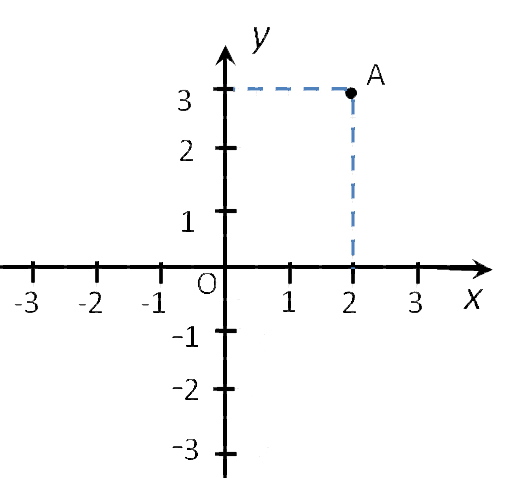
Каждой точке координатной плоскости соответствуют две координаты.
Координаты точки на плоскости — это пара чисел, в которой на
первом месте стоит
абсцисса, а на
втором —
ордината точки.
Рассмотрим как в системе координат (на координатной плоскости):
- находить координаты точки;
- найти положение точки.
Чтобы найти координаты точки на плоскости, нужно опустить из этой точки
перпендикуляры на оси координат.
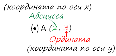
Точка пересечения с осью «x» называется абсциссой точки «А»,
а с осью y называется ординатой точки «А».
Обозначают координаты точки, как указано выше (·) A (2; 3).
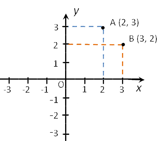
Пример (·) A (2; 3) и (·) B (3; 2).
Запомните!
![]()
На первом месте записывают абсциссу (координату по оси «x»), а на втором —
ординату (координату по оси «y») точки.
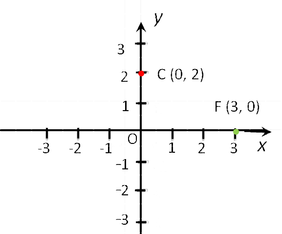
Особые случаи расположения точек
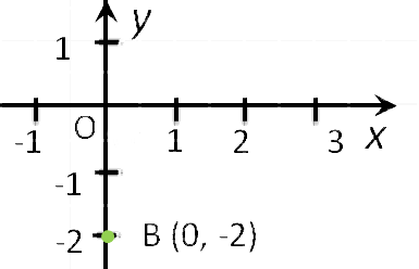
- Если точка лежит на оси «Oy»,
то её абсцисса равна 0. Например,
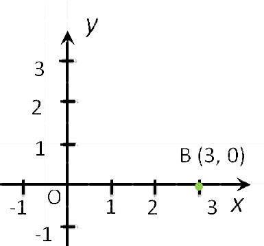
точка С (0, 2). - Если точка лежит на оси «Ox», то её ордината равна 0.
Например,
точка F (3, 0). - Начало координат — точка O имеет координаты, равные нулю O (0,0).
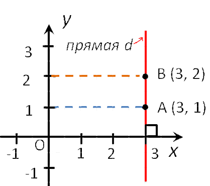
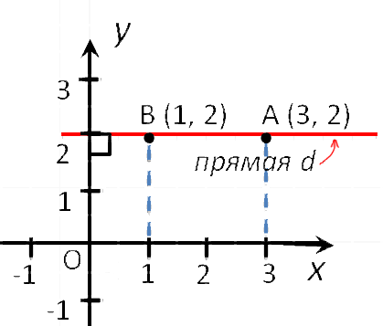
- Точки любой прямой перпендикулярной оси абсцисс, имеют одинаковые абсциссы.
- Точки любой прямой перпендикулярной оси ординат, имеют одинаковые ординаты.
- Координаты любой точки, лежащей на оси абсцисс имеют вид (x, 0).
- Координаты любой точки, лежащей на оси ординат имеют вид (0, y).
Как найти положение точки по её координатам
Найти точку в системе координат можно двумя способами.
Первый способ
Чтобы определить положение точки по её координатам,
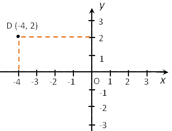
например, точки D (−4 , 2), надо:
- Отметить на оси «Ox», точку с координатой
«−4», и провести через неё прямую перпендикулярную оси «Ox». - Отметить на оси «Oy»,
точку с координатой 2, и провести через неё прямую перпендикулярную
оси «Oy». - Точка пересечения перпендикуляров (·) D — искомая точка.
У неё абсцисса равна «−4», а ордината равна 2.
Второй способ
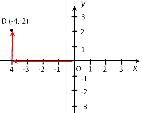
Чтобы найти точку D (−4 , 2) надо:
- Сместиться по оси «x» влево на
4 единицы, так как у нас
перед 4
стоит «−». - Подняться из этой точки параллельно оси y вверх на 2 единицы, так
как у нас перед 2 стоит «+».
Чтобы быстрее и удобнее было находить координаты точек или строить точки по координатам на
листе формата A4 в клеточку, можно скачать и использовать
готовую систему координат на нашем сайте.