Разбор слова «колорадо»: для переноса, на слоги, по составу
Объяснение правил деление (разбивки) слова «колорадо» на слоги для переноса.
Онлайн словарь Soosle.ru поможет: фонетический и морфологический разобрать слово «колорадо» по составу, правильно делить на слоги по провилам русского языка, выделить части слова, поставить ударение, укажет значение, синонимы, антонимы и сочетаемость к слову «колорадо».
![]()
Содержимое:
- 1 Как перенести слово «колорадо»
- 2 Синонимы слова «колорадо»
- 3 Значение слова «колорадо»
- 4 Склонение слова «колорадо» по подежам
- 5 Как правильно пишется слово «колорадо»
- 6 Ассоциации к слову «колорадо»
Как перенести слово «колорадо»
ко—лорадо
коло—радо
колора—до
Синонимы слова «колорадо»
Значение слова «колорадо»
1. восьмой по площади штат США, располагается на западе центральной части США, один из так называемых Горных штатов (Викисловарь)
Склонение слова «колорадо» по подежам
| Падеж | Вопрос | Единственное числоЕд.ч. | Множественное числоМн.ч. |
|---|---|---|---|
| ИменительныйИм. | что? | Колорадо | Колорадо |
| РодительныйРод. | чего? | Колорадо | Колорадо |
| ДательныйДат. | чему? | Колорадо | Колорадо |
| ВинительныйВин. | что? | Колорадо | Колорадо |
| ТворительныйТв. | чем? | Колорадо | Колорадо |
| ПредложныйПред. | о чём? | Колорадо | Колорадо |
Как правильно пишется слово «колорадо»
Правописание слова «колорадо»
Орфография слова «колорадо»
Правильно слово пишется:
Нумерация букв в слове
Номера букв в слове «колорадо» в прямом и обратном порядке:
Ассоциации к слову «колорадо»
-
Денвер
-
Ют
-
Штат
-
Калифорния
-
Техас
-
Калифорний
-
Каньон
-
Миссисипи
-
Аляска
-
Стэнли
-
Бакалавр
-
Огайо
-
Флорида
-
Плато
-
Торонто
-
Пенсильвания
-
Мэн
-
Мексика
-
Квебек
-
Ранчо
-
Монреаль
-
Прииск
-
Хоккеист
-
Уинстон
-
Колумбия
-
Курорт
-
Даллас
-
Лыжа
-
Филадельфия
-
Плотина
-
Вашингтон
-
Верховье
-
Юго-запад
-
Прерия
-
Джорджия
-
Вирджиния
-
Гора
-
Городок
-
Чикаго
-
Гранд
-
Раунд
-
Старатель
-
Отложение
-
Дамба
-
Шайба
-
Кортес
-
Предгорье
-
Приток
-
Городишко
-
Канада
-
Рудник
-
Джефферсон
-
Округа
-
Линкор
-
Бостон
-
Майами
-
Дельта
-
Долорес
-
Сити
-
Коэн
-
Нападающий
-
Университет
-
Альберта
-
Вратарь
-
Губернатор
-
Штаб-квартира
-
Эван
-
Моррисон
-
Река
-
Сиэтл
-
Поселенец
-
Колледж
-
Юго-восток
-
Переезд
-
Ареал
-
Запад
-
Сенатор
-
Остин
-
Северо-запад
-
Скалистый
-
Калифорнийский
-
Юго-западный
-
Хоккейный
-
Юго
-
Лыжный
-
Индейский
-
Флагманский
-
Мексиканский
-
Нью
-
Хилый
-
Военно-воздушный
-
Баскетбольный
-
Тихоокеанский
-
Юго-восточный
-
Обменять
-
Переехать
-
Покататься
-
Обыграть
-
Граничить
-
Округ
Правильное написание слова колорадо:
колорадо
Криптовалюта за ходьбу!
Количество букв в слове: 8
Слово состоит из букв:
К, О, Л, О, Р, А, Д, О
Правильный транслит слова: kolorado
Написание с не правильной раскладкой клавиатуры: rjkjhflj
Тест на правописание

§ 13. Географические названия
1. Географические названия пишутся с прописной буквы: Арктика, Европа, Финляндия, Кавказ, Крым, Байкал, Урал, Волга, Киев.
С прописной буквы пишутся также неофициальные названия территорий:
1) на -ье, образованные с помощью приставок за-, по-, под-, пред-, при-: Забайкалье, Заволжье; Поволжье, Пообье; Подмосковье; Предкавказье, Предуралье; Приамурье, Приморье;
2) на -ье, образованные без приставки: Оренбуржье, Ставрополье;
3) на -щин(а): Полтавщина, Смоленщина, Черниговщина.
2. В составных географических названиях все слова, кроме служебных и слов, обозначающих родовые понятия (гора, залив, море, озеро, океан, остров, пролив, река и т. п.), пишутся с прописной буквы: Северная Америка, Новый Свет, Старый Свет, Южная Африка, Азиатский материк, Северный Ледовитый океан, Кавказское побережье, Южный полюс, тропик Рака, Красное море, остров Новая Земля, острова Королевы Шарлотты, остров Земля Принца Карла, остров Святой Елены, Зондские острова, полуостров Таймыр, мыс Доброй Надежды, мыс Капитана Джеральда, Берингов пролив, залив Святого Лаврентия, Главный Кавказский хребет, гора Магнитная, Верхние Альпы (горы), Онежское озеро, город Красная Поляна, река Нижняя Тунгуска, Москва-река, вулкан Везувий.
В составных географических названиях существительные пишутся с прописной буквы, только если они утратили свое лексическое значение и называют объект условно: Белая Церковь (город), Красная Горка (город), Чешский Лес (горный хребет), Золотой Рог (бухта), Болванскай Нос (мыс). Ср.: залив Обская губа (губа — ‘залив’), отмель Куршская банка (банка — ‘мель’).
В составное название населенного пункта могут входить самые разные существительные и прилагательные. Например:
Белая Грива
Большой Исток
Борисоглебские Слободы
Верхний Уфалей
Высокая Гора
Горные Ключи
Гусиное Озеро
Дальнее Константиново
Железная Балка
Жёлтая Река
Зелёная Роща
Золотая Гора
Зубова Поляна
Каменный Яр
Камское Устье
Камышовая Бухта
Капустин Яр
Кичменгский Городок
Княжьи Горы
Конские Раздоры
Красная Равнина
Красный Базар
Липовая Долина
Липин Бор
Лисий Нос
Лиственный Мыс
Лукашкин Яр
Малая Пурга
Малиновое Озеро
Мокрая Ольховка
Мурованные Куриловцы
Мутный Материк
Нефтяные Камни
Нижние Ворцта
Новая Дача
Песчаный Брод
Петров Вал
Светлый Яр
Свинцовый Рудник
Свободный Порт
Сенная Губа
Серебряные Пруды
Старый Ряд
Турий Рог
Чёрный Отрог и т. п.
3. Части сложного географического названия пишутся с прописной буквы и соединяются дефисом, если название образовано:
1) сочетанием двух существительных (сочетание имеет значение единого объекта): Эльзас-Лотарингия, Шлезвиг-Гольштейн (но: Чехословакия, Индокитай), мыс Сердце-Камень;
2) сочетанием существительного с прилагательным: Новгород-Северский, Переславль-Залесский, Каменец-Подольский, Каменск-Уральский, Горно-Алтайск;
3) сложным прилагательным: Западно-Сибирская низменность, Южно-Австралийская котловина, Военно-Грузинская дорога, Волго-Донской канал;
4) сочетанием иноязычных элементов: Алма-Ата, Нью-Йорк.
4. Иноязычные родовые наименования, входящие в состав географических названий, но не употребляющиеся в русском языке в качестве нарицательных существительных, пишутся с прописной буквы: Йошкар-Ола (ола — ‘город’), Рио-Колорадо (рио — ‘река’), Сьерра-Невада (сьерра — ‘горная цепь’).
Однако иноязычные родовые наименования, вошедшие в русский язык в качестве нарицательных существительных, пишутся со строчной буквы: Варангер-фиорд, Беркли-сквер, Уолл-стрит, Мичиган-авеню.
5. Артикли, предлоги и частицы, находящиеся в начале иноязычных географических названий, пишутся с прописной буквы и присоединяются дефисом: Ле-Крезо, Лос-Эрманос, острова Де-Лонга. Так же: Сан-Франциско, Санта-Крус, Сен-Готард, Сент-Этьен.
6. Служебные слова, находящиеся в середине сложных географических названий (русских и иноязычных), пишутся со строчной буквы и присоединяются двумя дефисами: Комсомольск-на-Амуре, Ростов-на-Дону, Никольское-на-Черемшане, Франкфурт-на-Майне, Рио-де-Жанейро, Пинар-дель-Рио, Сан-Жозе-дус-Кампус, Сан-Жозе-де-Риу-Прету, Сан-Бендетто-дель-Тронто, Лидо-ди-Остия, Реджо-нель-Эмилия, Шуази-ле-Руа, Орадур-сюр-Глан, Абруццо-э-Молизе, Дар-эс-Салам.
7. Названия стран света пишутся со строчной буквы: восток, запад, север, юг; вест, норд, ост. Так же: северо-запад, юго-восток; норд-ост, зюйд-ост.
Однако названия стран света, когда они входят в состав названий территорий или употребляются вместо них, пишутся с прописной буквы: Дальний Восток, Крайний Север, народы Востока (т. е. восточных стран), страны Запада, регионы Северо-Запада.

![]() А
А![]() Б
Б![]() В
В![]() Г
Г![]() Д
Д![]() Е
Е![]() Ж
Ж![]() З
З![]() И
И![]() Й
Й![]() К
К![]() Л
Л![]() М
М![]() Н
Н![]() О
О![]() П
П
![]() Р
Р
р. (река) § 209
Ра § 180
рабски покорный § 131
раввин § 107
равеннцы § 109
равенство § 64 п. 2
равнение § 35 п. 1
равнина § 35 п. 1
равно § 35 п. 1
равновесие § 35 п. 1
равноденствие § 35 п. 1
равноправный § 35 п. 1
равносильный § 35 п. 1
равноценный § 35 п. 1
равный § 35 п. 1
равнять § 35 п. 1
равняться § 35 п. 1
равн — ровн § 35 п. 1
ради бога § 181 прим. 3
радий (о радии) § 71 п. 1
радикал-экстремизм § 121 п. 1
радио- § 117 п. 3
радиоактивный § 117 п. 3
радио-Буратино § 151
радио-мюзик-холл § 152
радиоприёмник § 117 п. 3
радиотелеуправление § 117 п. 3
радиофикация § 66
радостный § 83
рад-радёшенек § 118 п. 2
радуются не нарадуются § 155 а)
Раечка § 48
раёшник § 91
раёшный § 91
раз- (рас-)/роз- (рос-) § 40, § 82
разбирать § 36
раз-Брюллов § 151
развевать § 34
разведенец § 105
разведёнка § 105
разведчик § 86
разведывать § 61
разве не § 78 п. 4 а), § 147 п. 3
разверстый § 79 п. 2 б)
развёртывать § 61
разве что § 142 п. 2
развеянный § 60
развивать § 34
раздатчик § 87
раздать § 40
раздирать (раздеру) § 36
разжать § 89
разжечь § 40
разжигать § 36
раз за разом § 137 п. 4
раззвонить § 93
разлагать § 35 п. 1
разливанный (разливанное море) § 99 п. 3 а)
разливать § 40
разливной § 40
разлинованный § 98 п. 1
разлюли малина § 122 п. 3
размазывать § 61
размежёванный § 19 п. 2
размежёвка § 19 п. 3
размежёвывание § 19 п. 2
размежёвывать § 19 п. 2
размер/вес § 114
размешанный § 60
разминать § 36
размозжить § 106
размягчённый § 19 п. 5
размягчить § 79 п. 2 б) прим.
раз на раз § 137 п. 4
разниться § 35 п. 1
разница § 35 п. 1
разноголосица § 35 п. 1
разнородный § 35 п. 1
разносторонний § 35 п. 1
разносчик § 88
разнотипный § 128 п. 3 а)
разн — розн § 35 п. 1
разный § 35 п. 1
разобранный § 41
разобрать § 41
разовью § 41
разогнаться § 41
раз от разу § 137 п. 4
разредить § 34
разровнять § 35 п. 1
разрозненный § 35 п. 1
разрубить § 82
разрядить § 34
разъёмный § 27 п. 1 а)
разъехаться § 27 п. 1 а)
разыграть § 40
разыздеваться § 12 п. 2
разыскивать § 40
разыскной § 40
разэдакий § 6 п. 4 б)
Раичка § 48 прим.
райадминистрация § 26 п. 1
Райкин-младший § 159 прим.
район § 26 п. 2
районный совет народных депутатов § 193
райуполномоченный § 26 п. 1
ракетно-технический § 130 п. 3
рак-отшельник § 120 п. 1 б)
Рамазан (Рамадан) § 183
Рамбуйе § 26 п. 3
Рамсесы § 159
раненный § 98 п. 3
раненый § 60, § 98 п. 3
Раннее Возрождение § 179
ранний § 95
ранчо § 21
раным-рано § 118 п. 2
рапорт § 107
раса § 107
раскатисто-громкий § 129 п. 2
раскланяться § 35 п. 1
расковырянный § 60
раскорчёванный § 19 п. 2
распашонка § 18 п. 2
распаяться § 35 п. 1
распивочный § 43
распинать § 36
расписание § 40
расписка § 40
распустить § 40
распутанный § 98 п. 2 а)
рассказ «Дама с собачкой» § 195 а)
рассказчик § 88
рассориться § 96
расстелить § 36,
расстелет § 36 прим. 4
расстилать § 36, § 36 прим. 4
расстрелянный § 60
рассчитать § 36, § 93 прим.
рассчитывать § 93 прим.
рассыпать § 40, § 93
рассыпать § 40
рассыпной § 40
растение § 35 п. 1
растеньице § 52
растереть § 36
расти (расту) § 35 п. 1
растирание § 36 прим. 2
растирать § 36
растительность § 35 п. 1
растительноядный § 128 п. 3 а)
растить § 35 п. 1
растлевать § 62
растоптать § 82
растяпа растяпой § 122 п. 4 а)
расфасовать § 82
расхожий § 82
расценка § 82
расчёска § 19 п. 7, § 88
расчесть § 93 прим.
расчесться § 93 прим.
расчёсывать § 19 п. 7
расчёт § 18 п. 5, § 19 п. 7, § 93 прим.
расчётливый § 93 прим.
расчётный § 93 прим.
расчехлить § 88
расшевелить § 82
расшибить § 89
расщепление § 82
Рафаэлева Мадонна § 166
рахат-лукум § 121 п. 3
ращу § 35 п. 1
реакция § 79 п. 2 б)
ребятушки § 54
ревизия § 44
революция § 16
революция 1905 года § 179 прим. 5
ревю-оперетта § 120 п. 2
регби § 9
реестр § 7 п. 1
режьте § 32 в)
резус-фактор § 120 п. 4
резче § 88
резчик § 88
резюме § 9
рейтинг § 9
рейхсканцлер § 121 п. 2
рейхстаг § 191
река Волга § 122 п. 1 б)
реквием § 7 п. 1
реле-станция § 120 п. 2
религиоведение § 65
ре минор § 122 п. 6
ре-минорный § 129 п. 5
Ренессанс § 179
ренессанс § 194 прим. 5
ренклод § 198 прим.
рентген § 158, § 163
рентгеновы лучи § 166
реорганизованный § 98 п. 1
Рерих § 9
реснитчатый § 87
Республика Татарстан § 170
ретро- § 117 п. 3
ретромода § 117 п. 3
ретушёвка § 19 п. 3
ретушёр § 19 п. 4
Реформация § 179
речевой § 18 п. 3
речовка § 18 п. 3
решённый § 98 п. 2 б)
решённый-перерешённый § 99 п. 3
решёта (мн. ч.) § 19 п. 7
решетчатый § 19 п. 7
реэвакуация § 117 п. 1
реэкспорт § 6 п. 4 а)
Риего-и-Нуньес § 123 п. 5 прим. 1, § 160
риелтор § 7 п. 1
рижский § 90
риксдаг § 191
Римка § 109
римляне § 69
Римма § 107
Римский-Корсаков § 124 п. 1, § 159
Римско-католическая церковь § 184
Рио-де-Жанейро § 126 п. 6, § 169 прим. 2
рио-де-жанейрский § 129 п. 1
Рио-Колорадо § 169 прим. 3
Рио-Негро § 126 п. 5
р. и руб. (рубль) § 209
рислинг § 199 прим.
рисующий § 58
Ричард Львиное Сердце § 123 п. 2, § 159
р-н (район) § 210
Робеспьеры § 158
робин-гудовский § 129 п. 3
робинзон § 158
ровесник § 35 п. 1, § 83 прим.
ровненский § 55
ровный § 35 п. 1
ровнять § 35 п. 1
Рогожская Застава (площадь) § 169 прим. 1
Родина § 203
Родительская суббота § 183
рождаемость § 59
рождённый § 98 п. 2 б)
рождественский § 55
Рождество § 183
Роже Мартен дю Гар § 123 п. 3, § 123 п. 5, § 160
рожон § 18 п. 5
рожь § 32 а)
роз- (рос-)/раз- (рас-) § 40, § 82
роздал § 40
розданный § 40
розжиг § 36 прим. 3, § 40
розлив § 40
розмарин § 198 прим.
розниться § 35 п. 1
рознь § 35 п. 1
розыгрыш § 40
розыск § 12 п. 2, § 40, § 82
рок-ансамбль § 120 п. 4
рококо § 194 прим. 5
Рокфеллер-старший § 123 п. 2 прим., § 159 прим.
роман «Дворянское гнездо» § 195 а) «Роман без вранья» § 195 б)
Романовы § 159
ромбоэдр § 7 прим.
ромен-роллановский § 129 п. 3
ропот § 64 п. 3 а)
рос, росла, росли (прош. вр.) § 35 п. 1
рослый § 35 п. 1
роспись § 40, § 82
роспуск § 40
росс, (российский) § 209
Российская академия наук § 189
Российская Федерация § 170
российский § 106
Российский (в названиях) § 192 прим.
Российский научный центр «Курчатовский институт» § 192 прим.
Российское государство § 174
Россия § 106
Россияне § 106
Россыпь § 40
Рост § 35 п. 1
РОСТА (Российское телеграфное агентство) § 208 прим. 1
Ростов-на-Дону § 126 п. 6, § 157, § 169 прим. 2
ростовой § 35 п. 1
ростовщик § 35 п. 1
росток § 35 п. 1
рос(т) — рас(т) — ращ § 35 п. 1
росший § 89
рощ (род. п. мн. ч.) § 32
р/с и р/сч (расчётный счёт) § 210
рубашонка § 18 п. 2
Рудный Алтай (горная цепь) § 127
ружей (род. п. мн. ч.) § 64 п. 3
ружьецо § 52
рука об руку § 137 п. 4
руки-ноги § 118 п. 4
руководитель департамента § 196
рус. (русский) § 209
русалка § 162 прим. 2
русист § 106 прим.
русификация § 66, § 106 прим.
русифицированный § 106 прим. «Руслан» § 200
русофил § 106 прим.
русофоб § 106 прим.
Русская православная церковь § 184
русский § 95, § 106 прим.
Русский музей § 189
русскоговорящий § 106 прим.
русскоязычный § 106 прим., § 128 п. 3 б)
руставелиевский § 42 прим.
ручательство § 43
ручища § 70
ручонка § 18 п. 2
рушник § 91
рыба-попугай § 120 п. 1 б), § 122 п. 1 а) прим.
рыба треска § 122 п. 1 а)
рыбацкий § 85
рыжевато-коричневый § 129 п. 2
рыжеватый § 43
рыцарский § 30 п. 2 а) прим.
рэкет § 8 п. 1
рэкетир § 8 п. 1
Рэлей § 8 п. 2
рэлей § 8 п. 2
Рэмбо § 8 п. 2
рэп § 8 п. 1
рюкзак § 80
Рюриковичи § 159
Рязанщина § 30 п. 3 ![]() С
С![]() Т
Т![]() У
У![]() Ф
Ф![]() Х
Х![]() Ц
Ц![]() Ч
Ч![]() Ш
Ш![]() Щ
Щ![]() Ы
Ы![]() Э
Э![]() Ю
Ю![]() Я
Я
§ 169. В
географических и административно-территориальных названиях — названиях
материков, морей, озер, рек, возвышенностей, гор, стран, краев, областей,
населенных пунктов, улиц и т. п. — с прописной буквы пишутся все слова, кроме
родовых понятий (остров, море, гора, область, провинция, улица,
площадь и т. п.), служебных слов, а также слов года, лет,
напр.:
Альпы, Америка, Европа, Болгария, Новая
Зеландия, Северная Америка, Центральная Азия; Южный полюс, Северное полушарие;
Волга, Везувий, Большая Багамская банка,
водопад Кивач, долина Тамашлык, Голодная степь, залив Благополучия, котловина
Больших Озёр, ледник Северный Энгильчек, Днепровский лиман, мыс Доброй Надежды,
Абиссинское нагорье, Онежское озеро, Северный Ледовитый океан, Белое
море, плато Устюрт, Среднесибирское плоскогорье, полуостров Таймыр, Большая
Песчаная пустыня, Голубой Нил, Москва-река, Большой Барьерный риф, течение
Западных Ветров, тропик Рака, хребет Академии Наук, Главный Кавказский хребет;
Краснодарский край, Орловская область,
Щёлковский район, графство Суссекс, департамент Верхние Пиренеи, штат Южная
Каролина, округ Колумбия, область Тоскана, префектура Хоккайдо, провинция
Сычуань, Щецинское воеводство, Нижний Новгород, Киев, Париж, Новосибирск;
Тверская улица, улица Малая Грузинская, улица
26 Бакинских Комиссаров, Лаврушинский переулок, Арбатская площадь, Фрунзенская
набережная, проспект Мира, Цветной бульвар, Садовое кольцо, улица 1905 года,
площадь 50 лет Октября, Андреевский спуск, Большой Каменный мост.
В названиях, начинающихся на Северо- (и
Северно-), Юго- (и Южно-),
Восточно-, Западно-, Центрально-, с прописной буквы
пишутся (через дефис) оба компонента первого сложного слова, напр.: Северо-Байкальское нагорье, Восточно-Китайское море, Западно-Сибирская
низменность, Центрально-Чернозёмный регион, Юго-Западный территориальный округ.
Так же пишутся в составе географических названий компоненты других
пишущихся через дефис слов и их сочетаний, напр.: Индо-Гангская
равнина, Волго-Донской канал, Военно-Грузинская дорога, Алма-Атинский
заповедник, Сен-Готардский перевал (и туннель), земля Баден-Вюртемберг, мыс Сердце-Камень, Новгород-Северский,
Соль-Илецк, Усть-Илимск, Садовая-Сухаревская улица.
Примечание 1. Нарицательные существительные в
составных географических названиях пишутся с прописной буквы, если они
употреблены не в своем обычном значении, напр.: Новая Земля, Огненная Земля (архипелаги),
Золотой Рог (бухта),
Чешский Лес (горы),
Белая Церковь, Минеральные Воды,
Сосновый Бор, Вятские Поляны, Царское Село (города), Пушкинские Горы, Камское Устье
(поселки), Голодная Губа
(озеро), Большой Бассейн
(плоскогорье), Золотые Ворота
(пролив), Кузнецкий Мост, Охотный
Ряд, Земляной Вал (улицы), Никитские Ворота, Рогожская Застава (площади), Марьина Роща (район в
Москве), Елисейские Поля
(улица в Париже).
Примечание 2. Служебные слова (артикли,
предлоги, частицы), находящиеся в начале географических названий, пишутся с
прописной буквы, напр.: Под
Вязом, На Скалах (улицы), Лос-Анджелес, Ла-Манш, Лас-Вегас, Ле-Крезо, Де-Лонга. Также
пишутся начальные части Сан-,
Сен-, Сент-, Санкт-, Сайта-, напр.: Сан-Диего, Сен-Дени, Сент-Луис, Санта-Барбара,
Санкт-Мориц (города). Однако служебные слова, находящиеся в
середине географических названий, пишутся со строчной буквы, напр.: Ростов-на-Дону, Франкфурт-на-Майне,
Экс-ан-Прованс, Стратфорд-он-Эйвон, Рио-де-Жанейро, Шуази-ле-Руа,
Абруццо-э-Молизе, Дар-эс-Салам, Булонь-сюр-Мер.
Примечание 3. Некоторые иноязычные родовые
наименования, входящие в географическое название, но не употребляющиеся в
русском языке как нарицательные существительные, пишутся с прописной буквы,
напр.: Йошкар-Ола (ола — город), Рио-Колорадо (рио — река), Аракан-Йома (йома — хребет), Иссык-Куль (куль — озеро). Однако
иноязычные родовые наименования, которые могут употребляться в русском языке
как нарицательные существительные, пишутся со строчной буквы, напр.: Согне-фьорд, Уолл-стрит, Мичиган-авеню,
Пятая авеню, Беркли-сквер, Гайд-парк.
Примечание 4. Названия титулов, званий,
профессий, должностей и т. п. в составе географических названий пишутся с
прописной буквы, напр.: Земля
Королевы Шарлотты (острова), остров Принца Уэльского, мыс Капитана Джеральда, улица
Зодчего Росси, проспект Маршала Жукова. Аналогично пишутся
названия, в состав которых входит слово святой: остров Святой Елены, залив Святого Лаврентия.
Примечание 5. Слова, обозначающие участки
течения рек, пишутся со строчной буквы, если не входят в состав названий,
напр.: верхняя Припять, нижняя
Березина, но: Верхняя
Тура, Нижняя Тунгуска (названия рек).
![]()
| Штат США | ||
|
Колорадо |
||
 |
||
|
Девиз штата |
«Ничто без Провидения» | |
|
Прозвище штата |
«Штат Столетия» | |
|
Столица |
Денвер | |
|
Крупнейший город |
Денвер | |
|
Крупные города |
Колорадо-Спрингс, Форт-Коллинс, Арвада, Пуэбло, Вестминстер, Боулдер | |
|
Население |
5 782 171[1] (2020 год) 21-е по США |
|
| плотность | 21,40 чел./км² 39-е по США |
|
|
Площадь |
8-е место | |
| всего | 269 837 км² | |
| водная поверхность | (0,36 %) | |
| широта | 37°0′ с. ш. по 41°0′ с. ш., 612 км | |
| долгота | 102°8′ з. д. по 109°0′ з. д., 451 км | |
|
Высота над уровнем моря |
||
| максимальная | 4399 м | |
| средняя | 2073 м | |
| минимальная | 1011 м | |
|
Принятие статуса штата |
1 августа 1876 38 по счёту |
|
| до принятия статуса | Территория Колорадо | |
|
Губернатор |
Джаред Полис | |
|
Вице-губернатор |
Д. Примавера | |
|
Законодательный орган |
Генеральная Ассамблея | |
| верхняя палата | Сенат | |
| нижняя палата | Палата представителей | |
|
Сенаторы |
Майкл Беннет, Джон Хикенлупер |
|
|
Часовой пояс |
Горное время: UTC-7/-6 | |
|
Сокращение |
CO | |
|
Официальный сайт |
www.colorado.gov | |
|
|
Колора́до[2][3] (англ. Colorado, американское произношение: [ˌkɒləˈrædoʊ] (![]() слушать) или [ˌkɒləˈrɑːdoʊ]) — штат[4] на западе центральной части США, один из так называемых Горных штатов. Колорадо граничит со штатами Вайоминг (на севере), Небраска (на северо-востоке), Канзас (на востоке), Оклахома (на юго-востоке), Нью-Мексико (на юге), Аризона (на юго-западе), Юта (на западе).
слушать) или [ˌkɒləˈrɑːdoʊ]) — штат[4] на западе центральной части США, один из так называемых Горных штатов. Колорадо граничит со штатами Вайоминг (на севере), Небраска (на северо-востоке), Канзас (на востоке), Оклахома (на юго-востоке), Нью-Мексико (на юге), Аризона (на юго-западе), Юта (на западе).
Колорадо — восьмой по площади штат США, его площадь 269 837 км². Население штата — 5 782 171 человек (21-е по США)[1]. Столица и крупнейший город — Денвер. Другие крупные города — Арвада, Боулдер, Уэстминстер, Колорадо-Спрингс, Лейквуд, Орора, Пуэбло, Сентенниал, Торнтон, Форт-Коллинс.
Колорадо — 38-й штат США, он был образован 1 августа 1876 года, когда страна отмечала своё столетие. Из-за этого официальное прозвище Колорадо — «Столетний штат» (англ. Centennial State).
История[править | править код]
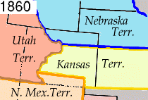
В начале XVI в. территорию будущего штата обследовали испанцы. С 1706 года территория Колорадо была объявлена колонией Испании. Своё название земля получила от реки Колорадо, которая в свою очередь была названа из-за красно-коричневого ила, содержащегося в воде. Затем провинция перешла к Франции. США получили восточную часть Колорадо в результате Луизианской покупки 1803 года. Центральная часть Колорадо перешла к США в 1845 году, а западная часть — в 1848 году, в результате войны с Мексикой.
В 1850-х годах неподалёку от Денвера было найдено золото, и сюда хлынули толпы переселенцев. В 1861 году началась Гражданская война. Многие золотоискатели сочувствовали Конфедерации, но большинство золотоискателей были верны Союзу. В 1862 году армия Конфедерации под командованием бригадного генерала Генри Хопкинса Сибли вышла из Форт-Блисс в Техасе и направилась вдоль Рио-Гранде, вторглась в северную часть Территории Нью-Мексико. Целью кампании был контроль над Территорией Колорадо, в частности золотыми приисками, и Калифорнией. 1-й полк добровольцев Колорадо под командованием полковника Джона Слау совершил переход из Денвера через перевал Ратон и 26 марта вступил в решающее сражение у перевала Глориета в горах Сангре-де-Кристо в Скалистых горах.
С 1863 по 1865 годы на землях территории Колорадо происходило вооружённое противостояние между белыми американцами, с одной стороны, и индейскими племенами арапахо, шайенов, сиу, кайова и команчей, с другой. Результатом стало переселение остатков племён арапахо, шайенн, кайова и команчей с территории Колорадо в резервации в Оклахоме.
3 марта 1875 года Конгресс США принял закон, определяющий требования к территории Колорадо, которые необходимо выполнить, чтобы стать штатом. Наконец, 1 августа 1876 года, спустя 28 дней после празднования столетия Дня независимости, президент США подписал указ, допускающий 38-й штат США к Союзу.
По переписи населения в 1930 году численность жителей штата превысила миллион человек. Колорадо сильно пострадал от Великой депрессии, но его состояние было восстановлено после Второй мировой войны. Важнейшими отраслями экономики штата стали горнодобывающая промышленность, сельское хозяйство и туризм.
В 1999 году в городе Литтл-Джефферсон произошло массовое убийство в школе Колумбайн. В итоге погибло 15 человек (включая нападавших), и было ранено 23 человека.
В 2014 году Колорадо стал первым штатом Америки, легализовавшим марихуану[5].
Герб и флаг[править | править код]
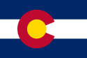
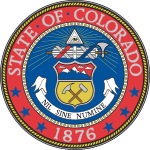
По закону 1911 года официальный флаг штата представляет собой прямоугольное полотнище. Красная буква «C» обозначает «Colorado» (штат назван по одноимённой реке), что в переводе с испанского языка значит «красный» (значение «цветной», «окрашенный», которое часто приводится в публикациях, является менее употребительным). Золотой шар внутри «C» говорит о наличии золотых приисков в штате. Голубые и белые полоски на флаге символизируют голубые небеса и белые снега Скалистых гор Колорадо. На гербе штата, который был официально принят в 1877 году, треугольная фигура символизирует всевидящий глаз Бога. На гербе изображены горы штата, земля и кирка, которые символизируют горнодобывающую промышленность Колорадо — основу экономики штата.
География[править | править код]

Великий континентальный раздел
Колорадо — один из трёх штатов (наряду с Вайомингом и Ютой), все границы которого представляют собой параллели и меридианы, и, как и Вайоминг, образует просто «прямоугольник» (точнее, сектор земной поверхности) между парой широт и парой долгот. Площадь занимаемой Колорадо территории — 269 837 км². 37 % территории Колорадо занимают национальные парки.
Рельеф[править | править код]
Рельеф Колорадо разнообразен. В центральной части территория штата пересекается с севера на юг хребтами Скалистых гор (высшая точка — гора Элберт, 4399 м). Они образуют так называемый Великий континентальный раздел: реки, протекающие западнее этих гор, относятся к бассейну Тихого океана, а те реки, которые находятся восточнее, относятся к бассейну Атлантического океана. Склоны гор большей частью покрыты хвойным лесом — лишь немногие вершины круглый год находятся под снегом. Бо́льшая часть населения штата проживает рядом с восточными склонами гор, так как это место защищено от штормовых ветров Тихого океана. В Колорадо находятся 55 из 104 горных вершин США, имеющих абсолютную высоту более 4000 метров и относительную — более 500 метров.
Восточнее Скалистые горы переходят в Великие равнины — плато с преобладающей степной растительностью. На Западе штата находится плато Колорадо — полупустынная зона с каньонами, останцами и другими характерными формами рельефа.
Горы[править | править код]
Вершина горы Элберт на высоте 14 440 футов (4401,2 м) в округе Лейк является самой высокой точкой в Колорадо и Скалистых горах Северной Америки[6]. Колорадо является единственным штатом США, который полностью лежит на высоте более 1000 метров. Место, где река Арикэри вытекает из округа Юма, штат Колорадо, и впадает в округ Шайенн, штат Канзас, является самой низкой точкой в штате Колорадо на высоте 3317 футов (1011 м). [7]
Климат[править | править код]
Климатическая картина Колорадо неоднородная: южная часть штата не всегда теплее северной, на климат сильно влияют Скалистые горы: с увеличением высоты температура понижается, а влажность повышается. По климатическим условиям штат делится на две части: восточные равнины и западные предгорья.
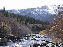
Река Арканзас в штате Колорадо
На востоке климат умеренно континентальный: низкая влажность, умеренные осадки (380—630 мм в год). Здесь отмечена одна из самых высоких среднесуточных температур в США. Летом температура возрастает до 35 °C (в среднем), а зимой может опуститься до −18 °C.
Климат западного Колорадо более однородный. Здесь присутствуют засушливые места, на возвышенностях горный климат. Самый жаркий месяц — июль (21 °C). Зима здесь очень влажная, что является противоположностью восточной части штата.
Гидрография[править | править код]
Река Колорадо — одна из крупных в штате. Здесь, на севере находится её исток. Она протекает в западной части Колорадо. На юге штата находится исток ещё одной крупной реки — Рио-Гранде. Она берёт своё начало в Скалистых горах и спускается к югу. Можно выделить и реку Арканзас, исток которой также находится в Колорадо. Она течёт на восток по Великим равнинам и затем впадает в реку Миссисипи. Ещё одна крупная река штата — Саут-Платт.
Крупнейшее по площади и по глубине в штате озеро — Гранд-Лейк, второе место занимает озеро Сан-Кристобал.
Население[править | править код]
По данным на июль 2013 года в Колорадо проживают 5 268 367 человек. Прирост населения велик за счёт высокой рождаемости и большого количества иммигрантов. Наибольший рост населения ожидается у восточного подножия Скалистых гор, особенно в Денвере.
Самый густонаселённый город штата и его столица — Денвер. В его агломерации Денвер-Орора-Боулдер проживает 2 927 900 человек, то есть приблизительно две трети всего населения штата.
В Колорадо проживает большое количество испанцев. Они проживают преимущественно в Денвере и на юге штата и являются потомками первых поселенцев этих земель. В результате переписи населения 2000 года выяснилось, что 10,5 % жителей штата говорят на испанском языке.
Также на территории штата проживают множество афроамериканцев, людей китайской, корейской и прочих национальностей. Преимущественно они проживают на востоке Денвера, в районе Орора. Многие из них являются потомками переселенцев, прибывших на территорию Колорадо во время золотой лихорадки.
Религиозный состав[править | править код]

Католическая церковь неподалёку от города Боулдер
Христианство — самая популярная религия штата — её исповедуют 65 % населения. Протестантизм — самая популярная ветвь христианства — её исповедуют 44 % жителей Колорадо. Католицизм исповедуют около 19 % населения штата.
Религиозный состав населения штата Колорадо:
- Христианство — 65 %
- Протестантизм — 44 %
- Католицизм — 19 %
- Мормоны — 2 %
- Православие — 1 %
- Иудаизм — 2 %
- Ислам — 1 %
- Другие религии — 5 %
- Атеизм — 25 %
В среднем в США 17 % атеистов, в Колорадо — 25 %.
Экономика[править | править код]

Кукурузная плантация в Колорадо

ВВП штата Колорадо в 2007 году был равен 236 миллиардов долларов. На душу населения доход составлял $ 41 192. По этому показателю штат занимает 11-е место в США. С середины XIX века основу экономики штата стали составлять горнодобывающая промышленность и сельское хозяйство. Во второй половине XX века возросла роль сферы услуг.
В Колорадо развита пищевая промышленность, машиностроение, химическая промышленность, металлургия. В штате имеются месторождения и добыча угля, нефти, природного газа, ванадия, урана, цинка, золота, серебра и молибдена. Штат является одним из лидеров в США по производству пива. Экономика штата отличается высокой технологичностью и хорошим качеством.
Денвер является важнейшим финансовым центром Колорадо. В нём расположены монетный двор, несколько крупных банков. Работают предприятия пищевой промышленности, машиностроения, лёгкой промышленности.
В Колорадо подоходный налог равен 4,63 % вне зависимости от размера дохода. В отличие от большинства штатов, где налог рассчитывается на основе «федерального скорректированного валового дохода», в штате Колорадо налоговой базой считается «налогооблагаемый доход» (доход после федеральных льгот и федеральных стандартных отчислений). В штате недвижимость и личные предприятия подлежат налогообложению, а государственное имущество было освобождено от этого в 2003 году. По состоянию на январь 2010 года уровень безработицы в Колорадо 7,4 %.
См. также[править | править код]
- Список городов Колорадо по численности населения
Примечания[править | править код]
Ссылки[править | править код]
- colorado.gov (англ.) — официальный сайт штата Колорадо
Внимание! Copyright
! Перепечатка возможна только с письменного разрешения автора. . Нарушители авторских прав будут преследоваться в соответствии с действующим законодательством.
Маша Денежкина, Таня Марчант
В оригинале:
Colorado
Столица:
Denver
)
Вошёл в состав США
: 1 августа 1876 года
Площадь:
269,7 тысяч кв.км
Население:
5,024 тыс. человек (2009 год)
Крупнейшие города:
Denver, Colorado Springs, Aurora Lakewood, Fort Collins, Arvada, Pueblo, Westminster, Boulder, Thornton

Колорадо – штат, знаменитый потрясающими природными ландшафтами пояса Скалистых гор (Rocky Mountain).
Впечатляющая уникальная красота заснеженных скал, покрытых хвойными лесами и мягкий климат штата, окруженного и защищенного от ветров поясом гор, сделали Колорадо центром летнего туризма США.

Зимой снежные склоны гор, сверкающие под теплыми лучами солнца, привлекают любителей горнолыжного спорта. Облюбовав знаменитые лыжные курорты штата, в Колорадо съезжаются многочисленные туристы не только из США, но и со всего мира. Ежегодно миллионы гостей штата прибывают в известные туристические горные районы Колорадо: Аспен (Aspen), Ист Парк (Estes Park) и Колорадо Спрингс (Colorado Springs).
Но не только горы Колорадо, привлекающие туристов, дают огромный доход в казну штата. Большинство граждан штата живет и работает в его восточной части — в сухой равнинной местности, которая занимает две пятых территории Колорадо.
Тоннели, прорубленные в горах, доставляют воду в сухие прерии, в большие города и фермерские районы штата. Земли Колорадо расположены на полпути между центральными городами Калифорнии и Средним Западом США. Поэтому штат служит главной транспортной артерией и грузосортировочным центром для всего района Скалистых гор.

Во многих отраслях промышленности компании Колорадо являются лидирующими. Важнейшими отраслями сельско-зозяйственной промышленности штата можно назвать мясомолочное животноводство и овцеводство. Мелиоративные проекты штата позволили фермерам Колорадо успешно заниматься выращиванием картофеля, зерна и сахарной свеклы. В районах бывших сухих пустынных прерий сейчас располагаются бескрайние поля кукурузы.
Одной из важнейших отраслей экономики штата является горнодобывающая промышленность. В 1850 году в Колорадо случился первый «горный бум».
Истории времён золотой и серебряной лихорадки в Колорадо, берущей начало с 1850 года, передаются как легенды. Такие известные мюзиклы, как комедия «Непотопляемая Молли Браун» (The Unsinkable Molly Brown) и опера «Баллада о малыше До» (The Ballad of Baby Doe) хорошо описывают события, происходившие в Колорадо во время «горного бума».
В шахтах Колорадо и сейчас добывают золото и серебро. Но теперь важнейшим объектом горнодобывающей промышленности штата является нефть, а также — производство бензина.

Колорадо – лидирующий штат США по добыче молибдена и производству стали. Один из «монетных дворов» Соединенных Штатов находится в столице Колорадо, городе Денвере.
Владельцем более чем третьей части земель Колорадо является государство. Правительство США контролирует использование этих территорий для пастбищ и разработки полезных ископаемых.
Правительство также является крупным заказчиком компаний Колорадо, занятых в индустрии приборостроения для космических исследований. Близ города Колорадо Спрингс располагается Академия ВВС, штаб-квартира которой находится у подножия горы Шаен, а центр финансирования – в столице штата, Денвере.
По-испански слово «colorado» означает «окрашенный в красный». Это имя изначально было дано реке Колорадо, которая протекала через каньон в скалах, камни которых имели красноватый оттенок. Штат был назван в честь реки. Иначе Колорадо еще называют «Штат Столетия» (Centennial State), поскольку Колорадо вошел в Союз США в 1876 году – в год столетия знаменитой Декларации Независимости. Самый крупный город штата — его столица город Денвер.

Флаг и герб штата Колорадо

В 1911 году штат Колорадо принял закон об официальном флаге. Красная буква «С» обозначает «Colorado», что в переводе с испанского языка, читается как «красный цвет» (colored red). Золотой шар внутри «С» говорит о наличии золотых приисков в штате. А голубые и белые полоски на флаге символизируют голубые небеса и белые снега Скалистых гор Колорадо.
На гербе штата, который был официально принят в 1877 году, треугольная фигура символизирует всевидящий глаз Бога. Также на гербе изображены горы штата, земля и кирка, которые символизируют горнодобывающую промышленность Колорадо — основу экономики штата.
Колорадо располагается в возвышенной зоне. Его земли лежат на высоте 2100 метров над уровнем моря, и это — самый «высотный» штат государства.
Первой благотворительной организацией в столице штата — Денвере, стал фонд помощи, созданный в 1887 году, учрежденный священником, рабби и двумя министрами. Фонд был назван «Общественная Благотворительная Служба» (Charity Organization Society).
Самый крупный серебряный самородок, который когда-либо находили в Северной Америке, был обнаружен в 1894 году в районе города Аспен. Самородок весил 835 кг и поныне именно он является самым крупным в мире серебряным слитком.
Было время, когда Колорадо в один день было три губернатора. В 1905 году губернатором штата был Альва Адамс (Alva Adams). Но после двух месяцев службы на этом посту он был вынужден уйти в отставку, ибо его уличили в мошенничестве на выборах. 17 марта 1905 года Адамс покинул губернаторское кресло, и
законодательное собрание штата призвало на пост губернатора Джеймс Пибоди (James H. Peabody). Тот отказался от предложенной должности, и в тот же день офис губернатора штата возглавил бывший вице-губернатор Джесси Макдональд.

Национальный парк «Великие Песчаные Дюны» (Great Sand Dunes National Monument) называют одним из удивительнейших чудес природы. Эти громадные массивы песка, лежащие у подножия гор Сангре Де Кристо (Sangre de Cristo Mountains) в центральном южном районе Колорадо, постоянно движутся и принимают причудливые формы. Иногда высота песочных дюн достигает 210 метров.
Центр деловой, финансовой и промышленной активности штата, Колорадо Спрингс (Colorado Springs) – крупнейший туристический центр штата, а также – военный центр, в районе которого расположено несколько военных баз, в том числе Академия ВВС. Крупнейшим городом на западе Колорадо является Гранд Джанкшон (Grand Junction).
Музеи, туризм

В Музее Искусства города Денвер (The Denver Art Museum) собрана большая коллекция изделий американских индейцев, а Музей Естественной Истории (г. Денвер) представляет большую экспозицию животных континента.
Прекрасный штат ежегодно привлекает миллионы туристов. Летом гости Колорадо заполняют высокогорные лыжные курорты. На склонах гор, в лесах, у берегов горных ручьев туристы располагают свои палаточные лагеря и кемпинги. Альпинисты пробуют свои силы в восхождении на многочисленные пики Скалистых гор.
Старые шахтерские городки и индейские деревни интересны для туристов – краеведов. Любители рыбалки ловят форель в чистых горных реках штата. Осенью охотники бродят в лесах штата в поисках многочисленных оленей.

Зимой вновь заполняются лыжные курорты Аспен (Aspen) Арапахо Бэзин (Arapahoe Basin), Стимбот Спрингс (Steamboat Springs), Вейл (Vail) и Винтер Парк (Winter Park). Лыжный сезон в Колорадо начинается в ноябре и заканчивается в апреле.
В городе Гранд Джанкшон (Grand Junction) находится Музей Долина Динозавров (The Dinosaur Valley Museum), который представляет коллекцию ископаемых животных доисторического периода.
Природа штата
Главные районы Колорадо — это Плато Колорадо; Межгорье; Скалистые горы; Великие прерии.
(The Colorado Plateau) лежит вдоль западной границы штата и занимает пятую часть его территории. Это район высоких холмов, плато и долин. На этих землях фермеры выращивают различные сорта злаковых культур. А в летние месяцы на лугах плато пасутся многочисленные стада коров и овец.

Межгорье
(Intermontane Basin) находится на севере плато и является самым маленьким районом штата. Это регион небольших холмистых возвышенностей, которые лежат между горами на северо-западе штата. Слово «intermontane» означает «между горами». Этот район холмистых возвышенностей покрывают леса и луга, которые являются прекрасными пастбищами для овец.

(The Rocky Mountains) лежат в средней части Колорадо и покрывают две пятых территории штата. Горы Колорадо называют Крышей Северной Америки.
Около 55 высочайших пиков, возвышающихся на 4 270 км над уровнем моря, расположены в этом районе. Эти высоты являются высочайшими вершинами цепи Скалистых гор, которая тянется от штата Аляска до Нью-Мексико.
Скалистые горы в свою очередь, тоже состоят из пяти горных цепей: Front Range, Park Range, Sawatch Range, San Juan Mountains, Sangre de Cristo Mountains.

Восточная группа Front Range включает такие высокие горы, как гора Ивэнс (Mount Evans), высота которой 4348 метров, Лонгз Пик (Longs Peak) высотой 4345 метров, Пайкс Пик (Pikes Peak) высотой 4301 метров и другие горы, высота которых растет к западу от Денвера и Колорадо Спрингз.
Цепь гор Sangre de Cristo (Кровь Христа) лежит на юге цепи Front Range. Вместе же горные цепи Front Range и Sangre de Cristo являются своеобразной стеной, которая ограждает район Великих Прерий, расположенных на востоке штата.
Великие Прерии
востока Колорадо покрывают примерно две пятых территории штата. Район великих прерий Колорадо — это часть обширной Северо-Американской Равнины, которая тянется от Канады до Мексики. Она плавно возвышается с востока на запад от подножия Скалистых гор. Когда-то фермеры считали эти территории непригодными для сельского хозяйства. Но современные ирригационные проекты в долинах сделали некогда сухие земли пригодными для обширных территорий агропромышленной деятельности.
Реки и озера

Важнейшие реки многих штатов берут свое начало из крупнейшей водной артерии – реки Колорадо.
Истоки трех крупных водных систем Миссисиппи-Миссури расположены на восточных склонах Скалистых гор. Это реки Арканзас (Arkansas), Сауз Платт (South Platte) и Репабликен (Republican).
На западе Скалистых гор, в озере Гранд (Grand Lake) берет свое начало река Колорадо (Colorado River). Она несет свои воды через регион Middle Park к юго-западу штата Юта и занимает двенадцатую часть территории США.
Несколько главных притоков реки Колорадо, включая Анкомпагре (Uncompahgre), Джаннисон (Gunnison), Сан Хуан (San Juan) и Долорес (Dolores) также являются водными ресурсами штата Колорадо.
В районе реки Сан Хуан берет свое начало и река Рио-Гранде (Rio Grande), которая течет на востоке и юге штата Колорадо и пересекает его границу со штатом Нью Мексико. А река Ноз Платт берет начало на землях North Park и несет свои воды в штат Вайоминг.
Растительность

В виду огромного различия в высоте и влажности, на землях Колорадо произрастает множество самых разнообразных вариантов растений.
Интересно видовое многообразие кактусов и других растений пустынь, которые во множестве можно встретить в засушливых районах штата. Наиболее распространена в них «бизонья трава» (buffalo grass). Весной расцветают песчаные лилии, лютики, тысячелистники. Летом – коломбины, сирень, Индейские кисточки, горные лилии, маргаритки, ирисы и розы.
Более трети территории штата покрыто лесами хвойных пород деревьев: разнообразные виды осин, елей и сосен, а также разные виды кленов.
Климат
Преимущественно климат Колорадо сухой и солнечный. Но поскольку на территории штата между его различными районами существует разница в высоте, температура воздуха также варьируется в зависимости от расположения региона. В горах всегда холоднее, чем в долинах и на плато.
В городе Барлингтоне (Burlington), расположенном на равнинных землях, средняя температура января равняется –2°C. А в городе Лидвилле (Leadville), который находится в горах, в январе –8°C. Разница в летних температурах этих же городов составляет +23°C в Барлингтоне и +13°C в Лидвилле.
Самая высокая температура воздуха была зарегистрирована в Колорадо в июле 1888г в городе Беннетт (Bennett). Она равнялась +48 °C. А самая низкая температура была 1 февраля 1985г в городе Мейбелл (Maybell), когда градусник показал –52 °C!
Производство
Производственный товарооборот штата Колорадо ежегодно составляет 19 миллиардов долларов. В основном на производства штата поступают полуфабрикаты, которые заводы и фабрики Колорадо доводят до конечной кондиции готовых товаров.
В сфере промышленного производства Колорадо лидирующими отраслями являются компьютерная и электронная техника. Около 60% экспортного производства штата составляет электроника, так называемый «хай тек сектор». Компьютерная техника и электронное производство – преобладающая отрасль экономики штата. Компании, производящие электронную технику и компьютерное оборудование располагаются в городах Болдер, Колорадо Спрингз, Денвер и Форт Коллинз.
Другими не менее важными отраслями промышленности Колорадо следует назвать производство медицинской техники и детали для различных электрических приборов.
Вторым ведущим направлением промышленности Колорадо считается изготовление специальных машин и агрегатов для пищевого производства. Аппараты для пивоварения, конвейеры для разлива напитков по бутылкам, линии для упаковки мясных продуктов – вот основные механизированные линии для пищевой индустрии, производимые в Колорадо.
Третья по величине пивоваренная компания США «Coors Brewing Company» имеет свой «головной офис» в Колорадском городе Голден (Golden). Кроме этого, несколько других крупных американских пивоваренных компаний размещают свои производства в городе Форт Коллинз.
Другими лидирующими отраслями промышленности штата можно назвать оборудование для транспорта, химических производств и металлургию. Части автомобильных двигателей и аэрокосмического оборудования являются важнейшими объектами производства штата. Колорадо на государственном уровне лидирует по производству фармацевтических препаратов, а также чистящих и лакокрасочных материалов.
Горнорудная промышленность
Нефть, уголь и природный газ — важнейшие продукты горнодобывающей промышленности Колорадо. Округ Рио Бланко (Rio Blanco County), расположенный на северо-западе штата добывает наибольшее количество нефти Колорадо. Нефтяные залежи этих земель содержат половину подземных нефтяных запасов штата. Кроме того, на востоке Денвера так же обнаружены обширные залежи нефти.
Сельское хозяйство

Около 60% земель Колорадо занимают сельскохозяйственные угодья. В штате насчитывается около 29 тысяч различных ферм. От огромных ранчо до маленьких «truck» — овощных огородов.
Животноводческие хозяйства и продукция животноводства дает две трети прибыли от сельскохозяйственного производства штата. Производство говядины – основная отрасль фермерской продукции Колорадо, штат является одним из главных поставщиков говядины на государственном рынке.
Много лет работа на пастбищах и ранчо была важнейшей сферой деятельности жителей штата. Фермеры Колорадо и сейчас занимаются откармливанием скота. Но уже – применяя современные технологии сельского хозяйства. Операторы «кормовых пультов раздачи» закупают телят, откармливая их на ранчо до необходимой кондиции.
Разумеется, такой научно разработанный, «пищевой конвейер», обогащенный необходимыми для роста минеральными солями и витаминами, гораздо быстрее увеличивает массу животного, нежели натуральные пастбища. А более тяжелые по весу животные ценятся на рынке гораздо выше. Регион Грили (Greeley) является важнейшим районом откормки животных.
Молочное производство штата – самая главная отрасль сельского хозяйства Колорадо. Кроме того, Колорадо – лидер шерстяного и мясного овцеводства. Также в штате выращивают свиней и домашнюю птицу.
Перепечатка, публикация статьи на сайтах, форумах, в блогах, группах в контакте и рассылках допускается только при наличии активной ссылки
на сайт .
С XV в. до н. э. примерно до XII в. н. э. на нынешней территории Колорадо жили индейские племена, называвшие себя «анасази», представители развитой сельскохозяйственной цивилизации. Их возможные потомки — племена юта и шайен знакомы нам по американским вестернам.
В XVII в. на территорию будущего Колорадо приходят испанцы, которые дают региону нынешнее название. Вслед за ними прибывают французы из уже освоенной колонии Луизианы. Начинается длительная борьба за контроль над этой территорией.
В начале XIX в. Соединенные Штаты Америки оккупируют Колорадо, и в 1876 г. он становится тридцать восьмым штатом.
В течение 1913 г., благодаря одному норвежцу, среди местных жителей появилось пристрастие к лыжному спорту. Так Колорадо становится одним из главных центров «белого безумия» горнолыжного спорта. Еще раньше, в семидесятые годы XIX в., с появлением в регионе железной дороги сюда хлынули толпы золотоискателей. Но «золотая лихорадка» в Колорадо была недолгой.
На первый взгляд штат Колорадо представляет собой только скалы и горы, но на самом деле он изобилует достопримечательностями.
Большая часть штата Колорадо расположена на территории горного массива , по которому проходит климатическая граница между западными штатами (Калифорния, Юта и Невада), центральной и восточной частями США. Савотч — один из двух горных хребтов, который пересекает штат с севера на юг и служит гидрографической границей между бассейнами Тихого и Атлантического океанов.
Самая высокая вершина Колорадо — Элберт (4398 м).
Восточная часть Колорадо представляет собой равнинную область. Здесь занимаются животноводством и добывают в значительных объемах нефть, газ, олово, молибден, цинк, уголь и серебро.
Возле Колорадо-Спрингс располагаются офисы компаний, занимающихся электроникой и информационными технологиями.
В Колорадо туризм играет очень большую роль. Аспен, расположенный на 354 км юго-западнее Денвера, известен любителям зимнего спорта всего мира. Влиятельные и богатые персоны, ищущие ярких впечатлений, ежегодно приезжают сюда, чтобы насладиться захватывающими спусками.
Близ Колорадо-Спрингс расположен Сад Богов — скалы из красного и белого песчаника и других осадочных пород в окружении вечнозеленых кипарисов. Это удивительный пейзаж, особенно во время восхода солнца.
Непременно следует посетить Колорадо-Спрингс. Здесь находится восстановленное старинное ранчо, которое как будто пришло к нам из вестернов. Стоит прогуляться и по Национальному парку , который объявлен культурным наследием ЮНЕСКО. Здесь можно встретить следы пребывания первых жителей этого штата, относящиеся к культуре племен анасази.

Общая информация
Тридцать восьмой штат США (с 1876 г.).
Общие границы со штатами:
Вайоминг, Небраска, Канзас, Оклахома, Нью-Мексико, Аризона, Юта.
Столица:
Денвер 598 707 чел., в агломерации — 2 506 626 чел. (2008 г.).
Язык:
английский.
Валюта:
доллар США.
Религия:
христианство.
Самые значительные города:
Колорадо-Спрингс, Лейквуд, Боулдер, Пуэбло, Арвада.
Реки:
Колорадо. Арканзас, Саут-Платт, Рио-Гранде.
Горы:
хребет Медисин-Боу, хребет Савотч, Сан-Хуан.
Цифры
Площадь:
269 837 км 2 .
Население:
4 301 261 чел. (2000 г.).
Плотность населения:
15,9 чел./км 2 .
Средняя высота над уровнем моря:
2100 м.
Высочайшая точка:
Элберт (4398 м).
Экономика
Полезные ископаемые:
металлические руды, уголь, природный газ, уран.
Сельское хозяйство:
выращивание картофеля, сахарной свеклы, животноводство.
Любопытные факты
■ Колорадо по-испански означает — «окрашенный в красные тона». Видимо, все дело в том, что река Колорадо течет между скал красного оттенка.
■ С 1858 по 1860 г. Денвер, главный город Колорадо, назывался Аурариа.
■ Близ Колорадо-Спрингс находится одно из самых значительных учебных заведений США — Академия ВВС Соединенных Штатов Америки.
■ Около 1850 г. свыше 10 000 человек, охваченных «золотой лихорадкой», в погоне за удачей устремились в Колорадо-Спрингс.
Не смотря на обильно падающий снег, нам удалось улететь из мокрого и грязного Нью-Йорка
И хотя в новостях пишут что через полчаса после нашего отлета из аэропорта LaGuardia
там выкатился за пределы ВПП самолет а/к Delta
, наш United
обильно политый красноватой незамерзайкой и заведенный с толкача, проваливаясь в воздушные ямы так что народ охал и ахал… все же прорвался из циклонического плена где-то над Иллинойсом (штат США)

В Колорадо
(штат США) солнечно и безветренно
Совершенно другая Америка — улыбающаяся и дружелюбная
И хотя дороги сухие — нам сказали, что мы можем творить с арендованной машиной все что хотим — она полностью застрахована
Выбор автомобиля для аренды в США
До места домчались за час…
Путешествие по США началось!
Первая остановка: недалеко от города Colorado Springs
парк Garden of the Gods
(Сад Богов)

Приложения
:
Нью-Йорк:
Рекомендую остановиться в уютных домиках рядом с парком Garden of the Gods
: Sunflower Lodge

Чем дальше в глубь «одноэтажной Америки» — тем дешевле цены в магазинах и мотелях.
Попадаются бородатые и лохматые деды в засаленных комбинезонах. Они ездят на доисторических джипах типа Шевроле и не могут скрыть удивления увидев нас.

Оказывается Бивис и Бадхед — не вымышленные персонажи: их срисовали с молодых людей «одноэтажной Америки» — могу засвидетельствовать.

С погодно-климатическими поясами что-то неладное творится: выехали январской стужей, а после обеда вокруг была уже середина мая.
Яркое солнце на синем небе, а внизу снега с утыканными как у ежика спина иголками — соснами и ёлками
Путешествие по Колорадо продолжится завтра в Colorado National Monument

Выезд в национальный парк Colorado National Monument
находится в 6 км от городка Grand Junction
И хотя парк открывается в 9 часов, мы въехали туда в 8
Могли бы раньше — с первыми лучами Солнца

Выезд в парк стоит 10 долларов и мы заплатили эту таксу при выезде
В 8 часов в будке служащего парка никого не было
Всего в парке пробыли 3 часа, но есть энтузиасты, которые ходят здесь пешком и тратят несколько дней на изучение этого места
Ну, а мы движемся теперь на восток — горнолыжные курорты у нас в завтрашней программе


Прикол:
Сейчас остановились в Крейге (на 40 дороге по направлению к горнолыжному курорту Стимбот). Ну знаете… этот Крейг — 2 улицы 3 дома. На горизонте дымят две трубы какой-то обогатительной фабрики или ГРЭС… Остановились в отеле этого городка. Там еще перед входом объявление висит: «Вытирайте грязные ноги перед входом». Но сам отель очень неплохой: люкс 100 баксов с налогами
Так вот — разговорилась Икринка с девушкой с ресепшена (девушка — типичная жительница Крейга: толстая, с черно-красными волосами и обильным пирсингом)
Та как узнала что мы из России — говорит:
— Я в Россию очень хочу поехать….
— ?
— Вообще-то мне в Крейге нравится.
— ?
— В этом году будет мое первое путешествие — на Филиппины. Но мои друзья, с которыми я еду на Филиппины говорят, что нужно ехать в Россию
— Слушай, это плохая идея — тебе ехать в Россию
— ?
— Ты начнешь там у всех спрашивать «Как дела?»? а в России это не любят и за это можно в глаз получить
— Все равно я хочу в Россию поехать

Не перестаю радоваться дорогам в Колорадо: кругом снег, на улице минус, а асфальт чистый и сухой
Сегодня проехали по 40 дороге мимо горнолыжного курорта Стимбот
.
Что сказать: я предпочту ездить кататься в Италию и Австрию: компактно, уютно… а тут целый город.
Думаю, что остальные крупные горнолыжные курорты в США такого же плана.
Галочку поставил


Парк Скалистые горы или Rocky Mountain National Park
совершенно не впечатлил: группы туристов фотографирующих полудохлого оленя и создавших пробку, игры фризби на Bear Lake
. Всё как-то высосано из пальца
Нет, возможно вся красота она там …. за горизонтом и чтобы ее увидеть надо одеть снегоступы и пилить туда пару суток — но это не наш метод


Тем не менее могу порекомендовать остановиться в отдельном коттедже от Wildwood Inn
— очень мило, просторно, с видом на речку, в 3 км от въезда в парк. Да и еще рядом ресторан Headtrail
— довольно неплохие бургеры из лося

Только написал это сообщение — мне Икринка в окно с улицы стучит: Бери фотоаппарат — у нас на парковке лось!
Это не лось оказался, а олень

Сегодня решили протупить и более по Колорадо не ездить: продлили наше пребывание в Estes Park
забронировав дополнительную ночь в коттедже Wildwood Inn
и завтра после обеда улетаем в штат Юта — Солт Лейк Сити
и это будет вторая часть путешествия по США (всего их 4 — по США)

Сегодня вчерашний лось решил действовать решительно и продемонстрировал Икринке что он не лось, а олень
Проехались по 7 дороге вниз — все заезды в парк закрыты. Вообщем вывод такой: в национальном парке Rocky Mountain
делать зимой совершенно нечего. Лучше всего сюда приезжать осенью, когда желтеют-краснеют листья. Тогда здесь красиво и колорно, как впрочем и называется этот штат США

Штат Колорадо — это один из самых крупных регионов США. Ежегодно сюда приезжает множество туристов, чтобы посетить широко известные Скалистые горы и насладиться всеми преимущества пребывания среди впечатляющих ландшафтов.
Общая информация
Площадь этого региона равна 269,7 тысяч кв. км, а его население насчитывает немного более 5 тысяч человек. Столица штата Колорадо — Денвер — является также и самым большим городом на этой территории. Район известен своими прекрасными природными ландшафтами, включающими пояса Скалистых гор.
Большинство туристов приезжает сюда именно для того, чтобы полюбоваться величием заснеженных скал, красотой хвойных лесов и насладиться мягким климатом. Регион является центром летнего и зимнего
Самые крупные города штата Колорадо — это Лейквуд, Аврора, Пуэбло и другие.
Туризм и промышленность
Тысячи поклонников горнолыжного спорта ежегодно приезжают в Колорадо зимой, чтобы провести время на снежных склонах, сверкающих под яркими солнечными лучами. К слову, здесь собираются не только жители США, а и туристы со всего мира. Самые известные горные туристические районы Колорадо: Аспен, Ист Парк, Колорадо Спрингс.
Серьезный доход в казну правительства приносит не только туризм: Колорадо также является важным промышленным центом. Большинство жителей этого округа живут и работают в его восточной части, которая занимает две пятых всей территории Колорадо. Штат также известен тоннелями, прорубленными в горах для того, чтобы обеспечивать водой сухие прерии фермерских районов, которые являются важным источником дохода на этой территории. Поскольку земли Колорадо расположены между основными городами Калифорнии и Средним Западом, здесь проходят важные транспортные артерии, обеспечивающие грузосортировку в районе Скалистых гор.

Сельскохозяйственная промышленность
Что касается сельскохозяйственных отраслей промышленности и агрокультуры Америки, то и здесь лидирующие позиции занимает штат Колорадо. США очень зависит от продукции, произведенной в этом районе. Наиболее примечательными и доходными являются овцеводство и мясомолочное животноводство. Это обусловлено большим количеством земель, идеально подходящих для разведения скота.
Разнообразные улучшения, проводимые правительством, помогают фермерам приняться за успешное выращивание таких культур, как картофель, зерно и сахарная свекла. На сегодняшний день территории, ранее занимаемые пустынными прериями, представляют собой бескрайние

Горнодобывающая промышленность
Важной составляющей экономики США выступает горнодобывающая промышленность Колорадо. Штат обрел известность (благодаря богатым запасам ценных металлов) уже в 1850 годах. В этот период здесь появились первые искатели приключений, ставшие жертвами серебряной и золотой лихорадок. Кстати, эта область до сих пор изобилует ценными металлами, хотя самым важным пунктом горнодобывающей промышленности Колорадо теперь является нефть и, следовательно, производство бензина.
Кроме того, штат занимает лидирующие позиции по добыче молибдена и изготовлению стали. В Денвере, столице Колорадо, даже располагается монетный двор США.

Флаг и герб
Главный символ Колорадо — флаг — был официально принят в 1911 году. Буква «С» красного цвета, изображенная на полотне, обозначает «Colorado», что в переводе с испанского означает «красный цвет». Золотой шар внутри буквы говорит о существовании золотых приисков. Голубые и белые полоски знамени символизируют природные красоты этой земли, голубое небо и белые снега в Скалистых горах.
Герб штата был принят в 1877 году. Изображенный на нем треугольник обозначает всевидящее божье око. Здесь также присутствуют символы горнодобывающей промышленности штата, которая приносит основной доход в казну. Это горы, земля и кирка.

Штат находится по большей части на возвышенных территориях. Его земли расположены на высоте 2100 над уровнем моря, что делает Колорадо самым «высотным» штатом в США.
Первая благотворительная организация была создана в Денвере. Это был фонд помощи, учрежденный священником, двумя министрами и рабби в 1882 году. Он носил название Общественная Благотворительная Служба.
Самый большой серебряный слиток в мире был найден на территории именно этого штата. Это произошло в городе Аспен, в 1894 году. Вес необработанного самородка достигал 835 килограмм, что позволяет ему до сих пор оставаться самым крупным слитком в мире.
Однажды на политической арене штата за один день сменилось три разных губернатора. В 1905 им стал Альва Адамс, который после двух месяцев работы был снят с должности: его уличили в жульничестве во время выборов. Инцидент произошел 17 марта, в этот же день законодательное собрание штата приняло решение поручить этот пост Джеймсу Пибоди, но он отказался. Немного позже, но в тот же день, пост губернатора занял Джесси Макдональд, бывший вице-губернатор.

Скалистые горы
Эта горная система находится в средней линии Колорадо. Штат на две пятых покрыт внушительным массивом. Скалистые горы называют Крышей Северной Америки. Здесь находятся 55 самых высоких пиков, некоторые из них достигают 4270 км над уровнем моря. Горная система тянется от Аляски вплоть до Нью-Мексико, но на территорию Колорадо приходятся самые высокие участки. В свою очередь, скалистые горы подразделяются на пять цепей.

Достопримечательности
Природные живописные ландшафты — это основные достопримечательности, с которыми можно ознакомиться, посетив штат Колорадо. На карте национальных парков в первую очередь рекомендуется ознакомиться с такими местами, как Старый форт Бент, Черный Каньон и заповедник динозавров.
Подводя итог, надо отметить, что Колорадо — это отличное место для семейного отдыха на природе или для того, чтобы провести отпуск, покоряя заснеженные вершины. Для США этот штат является не только важным туристическим центром, но и отличным источником полезных ископаемых и сельскохозяйственной продукции.
На вершине скалистых гор берет свое начало великая река Колорадо. Она не самая длинная в стране и не может похвастаться протяженностью. Но все же общепризнанно в мире ее считают Великой. Дело в том, что в течении сотен тысяч лет ее неспешные воды формировали удивительный природный ландшафт, все глубже вгрызаясь в землю и скалы. Результатом ее работы стал Большой Каньон, глубина которого превышает 2000 метров.
Удивительно, но на карты Гранд Каньон был нанесен чуть больше ста лет назад, когда геолог Джон Пауелл с небольшой командой совершил сплав вдоль всего русла реки. Каким же было его удивление, когда он впервые увидел Большой Каньон и понял, что причиной его образования стала река Колорадо, которая терпеливо продолжает прорубать себе дорогу в в горных породах. В древние времена эти места всегда принадлежали индейцам и впоследствии эти земли, особенно район Монументов, стал главной сценической площадкой для съемок вестернов. Индейцы племени Навахо до сих пор обитают в этих местах в резервациях.
Сегодня река Колорадо является единственным источником воды на многие сотни километров вокруг, что постепенно приводит к обмелению реки. Больше двадцати тысяч туристов стремятся сплавиться от верховья реки до Калифорнийского залива. Но очереди из желающих так огромны, что приходится резервировать заявку за два года вперед. Альтернативным вариантом полюбоваться рекой Колорадо и Большим Каньоном является путешествие вдоль его русла пешком или на джипах.
Координаты
: 31.81543800,-114.80403900
Бассейн с мышьяком в Гранд Каньоне
Гранд Каньон сам по себе удивительное творение природы. Миллионы лет река Колорадо прокладывала себе путь к заливу через горы, гранитные скалы и пустынные равнины. Результатом ее труда стал Большой каньон, который таит в себе множество удивительных памятников природы. Сплавляясь по реке через его ущелье можно встретить самые необычные явления. Например Тыквенный ручей.
В глубине каньона 342 километре можно увидеть необычный природный резервуар на левом берегу реки. Его округлые пузатые стенки и правда напоминают тыкву оранжевого цвета. Если подплыть поближе и встать в лодке, можно увидеть, что внутри она полая и наполнена странной зеленовато-желтой водой. Мы не рекомендуем к ней даже прикасаться, не то что пить. Дело в том, что тыква это формирование известковых отложений на углекислых источниках. Тысячу лет воды наращивала вокруг себе стенки, которые со временем превратились в тыкву, наполненную водой источника.
Но самое необычное заключается не в форме, а в содержимом. Теплая вода в бассейне просто переполнена минералами — цинком, медью и свинцом. И мышьяком. Обычная норма содержания этого яда в воде составляет около 50 мг на 1 литр, но здесь на литр приходится 1100 мг мышьяка. Даже крошечный глоток из этой тыковки может привести к смерти. Фотографируясь рядом с бассейном или искупавшись в нем, тщательно сполосните тело проточной водой.
Координаты
: 35.91553200,-113.33420800
А какие достопримечательности Колорадо вам понравились? Рядом с фотограйией есть иконки, кликнув по которым вы можете оценить то или иное место.
Скалистые горы
Вряд ли где найдется место в Соединенных Штатах, подходящее для альпинизма и скалолазания, больше чем территория национального парка «Скалистые горы». Он находится по обе стороны Водораздельного хребта и включает в себя чуть ли не треть всего штата. Отличительная особенность этих скал — необычный уклон поверхности и множество разнообразных трещин и уступов, позволяющих без труда преодолевать большие расстояния. Единственную трудность составляет выбор комфортного сезона для восхождения.
В начале лета скалы покрыты снегом и льдом, отчего привычные маршруты принимают совершенно немыслимую траекторию подъема, что привлекает особую категорию альпинистов.
Координаты
: 42.38333300,-115.93333300
Национальный парк Меса-Верде раскинулся в юго-западной части штата Колорадо, в местечке Монтесума-Кантри. Общая площадь парка насчитывает около двухсот квадратных километров, а перепад высот колеблется между 1900 и 2600 метрами над уровнем моря. Главная достопримечательность парка многочисленные руины каменных жилищ, созданных в выветрившихся каньонах из песчаника древним народом, более известным как индейское племя анасази. Эти строения были возведены в XIII столетии и являются первым в истории американской архитектуры образцом «многоквартирного дома». Количество жилых посещений в таких домах составляло до ста отдельных помещений.
Название парку был дано в честь одноименного плато, возвышающегося на 600 метров над окружающей местностью, склоны которого покрыты хвойным лесом. В переводе с испанского языка «Меса-Верде» означает «Зеленый стол». Популярность этих мест стала повышаться во второй половине XIX века, когда испанские исследователи начали понимать всю ценность древних скал для жизни индейцев. Первым исследователем Меса-Верде стал Ричарду Уэзерил историк-любитель, занимавшийся изучением истории пуэбло, кроме того, большое значение имели археологические работы шведского геолога Густава Норденшельда.
В 1906 году, в целях защиты древностей от возможного вандализма, Меса-Верде получил официальный статус национального парка, а спустя 60 лет вошел в Национальный реестр исторических мест США. С сентября 1978 года парк входит в список Всемирного культурного и природного наследия ЮНЕСКО.
Координаты
: 37.18769000,-108.49226800
Часовня кадетов Академии ВВС США
Часовня кадетов Академии ВВС США расположена в штате Колорадо, на территории военного городка и тренировочной базы филиала академии летчиков военно-воздушных сил США. Часовня была построена в 1962 году в стиле модернизма, спроектировал ее архитектор Уолтер Нетч.
Величественный вид часовне придают семнадцать рядов стальных рам, заканчивающихся пиками на высоте в 50 метров. Строение состоит из трех уровней, в которых проходят службы для представителей католической, протестантской и иудейской конфессий.
Часовня является популярным туристическим объектом, ежегодно на нее приезжают посмотреть около 500000 человек. В 1996 году часовня была удостоена премии Американского института архитектуры, в 2004 году как часть кадетского корпуса она была признана Национальным историческим памятником США.
Координаты
: 38.96400800,-104.81479000
Клуб Beta
Денверский клуб Beta отличается своей экологической позицией. Его лаундж комнаты — зеленые и выполнены с помощью устойчивых экологических продуктов, которые были повторно переработаны и использованы для строительства клуба. Его обязательным правилом является переработка использованных материалов в центрах переработки, которые располагаются на основных точках движения в клубе. Такими материалами являются пластик, стекло, алюминий, бумага и другие. Девиз ночного клуба: «Мы зеленые», что полностью подтверждает их позицию.
Клуб оснащен мощной системой аудио и видео, освещения и спецэффектов. Все эти удобства влияют на качество музыки и, следовательно, на посетителей. Целью Beta является развитие клубной культуры, и он постоянно двигается в этом направлении. Заведение никогда не стоит на месте, оно движется, ищет способы своего расширения и усовершенствования. Его креативные идеи каждый раз радуют постоянных посетителей.
Координаты
: 39.75365300,-104.99535600
Самые популярные достопримечательности в Колорадо с описанием и фотографиями на любой вкус. Выбирайте лучшие места для посещения известных мест Колорадо на нашем сайте.
|
Colorado |
|
|---|---|
|
State |
|
| State of Colorado | |
|
Flag
Seal |
|
| Nicknames:
The Centennial State |
|
| Motto(s):
Nil sine numine |
|
| Anthem: «Where the Columbines Grow» and «Rocky Mountain High»[1] |
|
|
Map of the United States with Colorado highlighted |
|
| Country | United States |
| Before statehood | Colorado Territory |
| Admitted to the Union | August 1, 1876[2] (38th) |
| Capital (and largest city) |
Denver |
| Largest metro and urban areas | Denver |
| Government | |
| • Governor | Jared Polis (D) |
| • Lieutenant Governor | Dianne Primavera (D) |
| Legislature | General Assembly |
| • Upper house | Senate |
| • Lower house | House of Representatives |
| Judiciary | Colorado Supreme Court |
| U.S. senators | Michael Bennet (D) John Hickenlooper (D) |
| U.S. House delegation | 5 Democrats 3 Republicans (list) |
| Area | |
| • Total | 104,094 sq mi (269,837 km2) |
| • Land | 103,718 sq mi (268,875 km2) |
| • Water | 376 sq mi (962 km2) 0.36% |
| • Rank | 8th |
| Dimensions | |
| • Length | 380 mi (610 km) |
| • Width | 280 mi (450 km) |
| Elevation | 6,800 ft (2,070 m) |
| Highest elevation
(Mount Elbert[3][4][a]) |
14,440 ft (4,401.2 m) |
| Lowest elevation
(Arikaree River[4][a]) |
3,317 ft (1,011 m) |
| Population
(2020) |
|
| • Total | 5,773,714 |
| • Rank | 21st |
| • Density | 55.47/sq mi (21.40/km2) |
| • Rank | 37th |
| • Median household income | $75,200[5] |
| • Income rank | 9th |
| Demonym | Coloradan |
| Language | |
| • Official language | English |
| Time zone | UTC−07:00 (MST) |
| • Summer (DST) | UTC−06:00 (MDT) |
| USPS abbreviation |
CO |
| ISO 3166 code | US-CO |
| Latitude | 37°N to 41°N |
| Longitude | 102°02′48″W to 109°02′48″W |
| Website | www.colorado.gov |

| List of state symbols | |
|---|---|

Flag of Colorado |
|
Seal of Colorado |
|
| Slogan | Colorful Colorado |
| Living insignia | |
| Amphibian | Western tiger salamander Ambystoma mavortium |
| Bird | Lark bunting Calamospiza melanocoryus |
| Cactus | Claret cup cactus Echinocereus triglochidiatus |
| Fish | Greenback cutthroat trout Oncorhynchus clarki somias |
| Flower | Rocky Mountain columbine Aquilegia coerulea |
| Grass | Blue grama grass Bouteloua gracilis |
| Insect | Colorado Hairstreak Hypaurotis crysalus |
| Mammal | Rocky Mountain bighorn sheep Ovis canadensis |
| Pet | Colorado shelter pets Canis lupus familiaris and Felis catus |
| Reptile | Western painted turtle Chrysemys picta bellii |
| Tree | Colorado blue spruce Picea pungens |
| Inanimate insignia | |
| Color(s) | Blue, red, yellow, white |
| Dinosaur | Stegosaurus |
| Folk dance | Square dance Chorea quadra |
| Fossil | Stegosaurus Stegosaurus armatus |
| Gemstone | Aquamarine |
| Mineral | Rhodochrosite |
| Rock | Yule Marble |
| Ship | USS Colorado (SSN-788) |
| Soil | Seitz |
| Sport | Pack burro racing |
| Tartan | Colorado state tartan |
| State route marker | |
 |
|
| Lists of United States state symbols |
Colorado (,[6][7] other variants[8]) is a state in the Mountain West subregion of the Western United States. It encompasses most of the Southern Rocky Mountains, as well as the northeastern portion of the Colorado Plateau and the western edge of the Great Plains. Colorado is the eighth most extensive and 21st most populous U.S. state. The 2020 United States census enumerated the population of Colorado at 5,773,714, an increase of 14.80% since the 2010 United States census.[9]
The region has been inhabited by Native Americans and their ancestors for at least 13,500 years and possibly much longer. The eastern edge of the Rocky Mountains was a major migration route for early peoples who spread throughout the Americas. «Colorado» is the Spanish adjective meaning «red», the color of the Fountain Formation outcroppings found up and down the Front Range of the Rocky Mountains.[10] The Territory of Colorado was organized on February 28, 1861,[11] and on August 1, 1876, U.S. President Ulysses S. Grant signed Proclamation 230 admitting Colorado to the Union as the 38th state.[2] Colorado is nicknamed the «Centennial State» because it became a state one century (and four weeks) after the signing of the United States Declaration of Independence.
Colorado is bordered by Wyoming to the north, Nebraska to the northeast, Kansas to the east, Oklahoma to the southeast, New Mexico to the south, and Utah to the west, and touches Arizona to the southwest at the Four Corners. Colorado is noted for its vivid landscape of mountains, forests, high plains, mesas, canyons, plateaus, rivers, and desert lands. Colorado is one of the Mountain States, and is a part of the western and is often considered to be part of the southwestern United States.
Denver is the capital of and most populous city in Colorado. Residents of the state are known as Coloradans, although the antiquated «Coloradoan» is occasionally used.[12][13] Major parts of the economy include government and defense, mining, agriculture, tourism, and increasingly other kinds of manufacturing. With increasing temperatures and decreasing water availability, Colorado’s agriculture, forestry, and tourism economies are expected to be heavily affected by climate change.[14]
Colorado is one of the most educated, developed, and wealthiest states, ranking 3rd in percentage of population 25 and over with a bachelor’s degree and 8th in percentage of population 25 and over with an advanced degree, 9th on the American Human Development Index, 8th in per capita income and 9th in median household income.
History[edit]

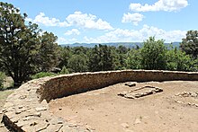
Great Kiva at Chimney Rock in the San Juan Mountains of Southwestern Colorado. It is said to have been built by the Ancient Pueblo peoples.
The region that is today the State of Colorado has been inhabited by Native Americans and their Paleoamerican ancestors for at least 13,500 years and possibly more than 37,000 years.[15][16] The eastern edge of the Rocky Mountains was a major migration route that was important to the spread of early peoples throughout the Americas. The Lindenmeier site in Larimer County contains artifacts dating from approximately 8720 BCE. The Ancient Pueblo peoples lived in the valleys and mesas of the Colorado Plateau.[17] The Ute Nation inhabited the mountain valleys of the Southern Rocky Mountains and the Western Rocky Mountains, even as far east as the Front Range of the present day. The Apache and the Comanche also inhabited the Eastern and Southeastern parts of the state. In the 17th century, the Arapaho and Cheyenne moved west from the Great Lakes region to hunt across the High Plains of Colorado and Wyoming.

The Spanish Empire claimed Colorado as part of its New Mexico province before U.S. involvement in the region. The U.S. acquired a territorial claim to the eastern Rocky Mountains with the Louisiana Purchase from France in 1803. This U.S. claim conflicted with the claim by Spain to the upper Arkansas River Basin as the exclusive trading zone of its colony of Santa Fe de Nuevo México. In 1806, Zebulon Pike led a U.S. Army reconnaissance expedition into the disputed region. Colonel Pike and his troops were arrested by Spanish cavalrymen in the San Luis Valley the following February, taken to Chihuahua, and expelled from Mexico the following July.
The U.S. relinquished its claim to all land south and west of the Arkansas River and south of 42nd parallel north and west of the 100th meridian west as part of its purchase of Florida from Spain with the Adams-Onís Treaty of 1819. The treaty took effect on February 22, 1821. Having settled its border with Spain, the U.S. admitted the southeastern portion of the Territory of Missouri to the Union as the state of Missouri on August 10, 1821. The remainder of Missouri Territory, including what would become northeastern Colorado, became an unorganized territory and remained so for 33 years over the question of slavery. After 11 years of war, Spain finally recognized the independence of Mexico with the Treaty of Córdoba signed on August 24, 1821. Mexico eventually ratified the Adams–Onís Treaty in 1831. The Texian Revolt of 1835–36 fomented a dispute between the U.S. and Mexico which eventually erupted into the Mexican–American War in 1846. Mexico surrendered its northern territory to the U.S. with the Treaty of Guadalupe Hidalgo after the war in 1848.
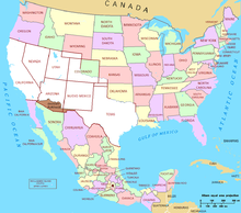
Most American settlers traveling overland west to the Oregon Country, the new goldfields of California, or the new Mormon settlements of the State of Deseret in the Salt Lake Valley, avoided the rugged Southern Rocky Mountains, and instead followed the North Platte River and Sweetwater River to South Pass (Wyoming), the lowest crossing of the Continental Divide between the Southern Rocky Mountains and the Central Rocky Mountains. In 1849, the Mormons of the Salt Lake Valley organized the extralegal State of Deseret, claiming the entire Great Basin and all lands drained by the rivers Green, Grand, and Colorado. The federal government of the U.S. flatly refused to recognize the new Mormon government, because it was theocratic and sanctioned plural marriage. Instead, the Compromise of 1850 divided the Mexican Cession and the northwestern claims of Texas into a new state and two new territories, the state of California, the Territory of New Mexico, and the Territory of Utah. On April 9, 1851, Mexican American settlers from the area of Taos settled the village of San Luis, then in the New Mexico Territory, later to become Colorado’s first permanent Euro-American settlement.

The Anasazi Heritage Center in Dolores
In 1854, Senator Stephen A. Douglas persuaded the U.S. Congress to divide the unorganized territory east of the Continental Divide into two new organized territories, the Territory of Kansas and the Territory of Nebraska, and an unorganized southern region known as the Indian territory. Each new territory was to decide the fate of slavery within its boundaries, but this compromise merely served to fuel animosity between free soil and pro-slavery factions.
The gold seekers organized the Provisional Government of the Territory of Jefferson on August 24, 1859, but this new territory failed to secure approval from the Congress of the United States embroiled in the debate over slavery. The election of Abraham Lincoln for the President of the United States on November 6, 1860, led to the secession of nine southern slave states and the threat of civil war among the states. Seeking to augment the political power of the Union states, the Republican Party-dominated Congress quickly admitted the eastern portion of the Territory of Kansas into the Union as the free State of Kansas on January 29, 1861, leaving the western portion of the Kansas Territory, and its gold-mining areas, as unorganized territory.
Territory act[edit]
Thirty days later on February 28, 1861, outgoing U.S. President James Buchanan signed an Act of Congress organizing the free Territory of Colorado.[11] The original boundaries of Colorado remain unchanged except for government survey amendments. The name Colorado was chosen because it was commonly believed that the Colorado River originated in the territory.[b] In 1776, Spanish priest Silvestre Vélez de Escalante recorded that Native Americans in the area knew the river as el Rio Colorado for the red-brown silt that the river carried from the mountains.[18][failed verification] In 1859, a U.S. Army topographic expedition led by Captain John Macomb located the confluence of the Green River with the Grand River in what is now Canyonlands National Park in Utah.[19] The Macomb party designated the confluence as the source of the Colorado River.
On April 12, 1861, South Carolina artillery opened fire on Fort Sumter to start the American Civil War. While many gold seekers held sympathies for the Confederacy, the vast majority remained fiercely loyal to the Union cause.
In 1862, a force of Texas cavalry invaded the Territory of New Mexico and captured Santa Fe on March 10. The object of this Western Campaign was to seize or disrupt the gold fields of Colorado and California and to seize ports on the Pacific Ocean for the Confederacy. A hastily organized force of Colorado volunteers force-marched from Denver City, Colorado Territory, to Glorieta Pass, New Mexico Territory, in an attempt to block the Texans. On March 28, the Coloradans and local New Mexico volunteers stopped the Texans at the Battle of Glorieta Pass, destroyed their cannon and supply wagons, and dispersed 500 of their horses and mules.[20] The Texans were forced to retreat to Santa Fe. Having lost the supplies for their campaign and finding little support in New Mexico, the Texans abandoned Santa Fe and returned to San Antonio in defeat. The Confederacy made no further attempts to seize the Southwestern United States.
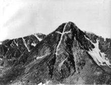
In 1864, Territorial Governor John Evans appointed the Reverend John Chivington as Colonel of the Colorado Volunteers with orders to protect white settlers from Cheyenne and Arapaho warriors who were accused of stealing cattle. Colonel Chivington ordered his troops to attack a band of Cheyenne and Arapaho encamped along Sand Creek. Chivington reported that his troops killed more than 500 warriors. The militia returned to Denver City in triumph, but several officers reported that the so-called battle was a blatant massacre of Indians at peace, that most of the dead were women and children, and that the bodies of the dead had been hideously mutilated and desecrated. Three U.S. Army inquiries condemned the action, and incoming President Andrew Johnson asked Governor Evans for his resignation, but none of the perpetrators was ever punished. This event is now known as the Sand Creek massacre.
In the midst and aftermath of the Civil War, many discouraged prospectors returned to their homes, but a few stayed and developed mines, mills, farms, ranches, roads, and towns in Colorado Territory. On September 14, 1864, James Huff discovered silver near Argentine Pass, the first of many silver strikes. In 1867, the Union Pacific Railroad laid its tracks west to Weir, now Julesburg, in the northeast corner of the Territory. The Union Pacific linked up with the Central Pacific Railroad at Promontory Summit, Utah, on May 10, 1869, to form the First transcontinental railroad. The Denver Pacific Railway reached Denver in June of the following year, and the Kansas Pacific arrived two months later to forge the second line across the continent. In 1872, rich veins of silver were discovered in the San Juan Mountains on the Ute Indian reservation in southwestern Colorado. The Ute people were removed from the San Juans the following year.
Statehood[edit]

The United States Congress passed an enabling act on March 3, 1875, specifying the requirements for the Territory of Colorado to become a state.[21] On August 1, 1876 (four weeks after the Centennial of the United States), U.S. President Ulysses S. Grant signed a proclamation admitting Colorado to the Union as the 38th state and earning it the moniker «Centennial State».[2]
The discovery of a major silver lode near Leadville in 1878 triggered the Colorado Silver Boom. The Sherman Silver Purchase Act of 1890 invigorated silver mining, and Colorado’s last, but greatest, gold strike at Cripple Creek a few months later lured a new generation of gold seekers. Colorado women were granted the right to vote on November 7, 1893, making Colorado the second state to grant universal suffrage and the first one by a popular vote (of Colorado men). The repeal of the Sherman Silver Purchase Act in 1893 led to a staggering collapse of the mining and agricultural economy of Colorado, but the state slowly and steadily recovered. Between the 1880s and 1930s, Denver’s floriculture industry developed into a major industry in Colorado.[22][23] This period became known locally as the Carnation Gold Rush.[24]
Twentieth and twenty-first centuries[edit]
Poor labor conditions and discontent among miners resulted in several major clashes between strikers and the Colorado National Guard, including the 1903–1904 Western Federation of Miners Strike and Colorado Coalfield War, the latter of which included the Ludlow massacre that killed a dozen women and children.[25][26] Both the 1913–1914 Coalfield War and the Denver streetcar strike of 1920 resulted in federal troops intervening to end the violence.[27] In 1927, the Columbine Mine massacre resulted in six dead strikers following a confrontation with Colorado Rangers.[28] More than 5,000 Colorado miners—many immigrants—are estimated to have died in accidents since records were first formally collected following an 1884 accident in Crested Butte that killed 59.[29]
In 1924, the Ku Klux Klan Colorado Realm achieved dominance in Colorado politics. With peak membership levels, the Second Klan levied significant control over both the local and state Democrat and Republican parties, particularly in the governor’s office and city governments of Denver, Cañon City, and Durango. A particularly strong element of the Klan controlled the Denver Police.[30] Cross burnings became semi-regular occurrences in cities such as Florence and Pueblo. The Klan targeted African-Americans, Catholics, Eastern European immigrants, and other non-White Protestant groups.[31] Efforts by non-Klan lawmen and lawyers including Philip Van Cise lead to a rapid decline in the organization’s power, with membership waning significantly by the end of the 1920s.[30]

Colorado became the first western state to host a major political convention when the Democratic Party met in Denver in 1908. By the U.S. census in 1930, the population of Colorado first exceeded one million residents. Colorado suffered greatly through the Great Depression and the Dust Bowl of the 1930s, but a major wave of immigration following World War II boosted Colorado’s fortune. Tourism became a mainstay of the state economy, and high technology became an important economic engine. The United States Census Bureau estimated that the population of Colorado exceeded five million in 2009.
On September 11, 1957, a plutonium fire occurred at the Rocky Flats Plant, which resulted in the significant plutonium contamination of surrounding populated areas.[32]
From the 1940s and 1970s, many protest movements gained momentum in Colorado, predominantly in Denver. This included the Chicano Movement, a civil rights, and social movement of Mexican Americans emphasizing a Chicano identity that is widely considered to have begun in Denver.[33] The National Chicano Liberation Youth Conference was held in Colorado in March 1969.[34]
In 1967, Colorado was the first state to loosen restrictions on abortion when governor John Love signed a law allowing abortions in cases of rape, incest, or threats to the woman’s mental or physical health. Many states followed Colorado’s lead in loosening abortion laws in the 1960s and 1970s.[35]
Since the late 1990s, Colorado has been the site of multiple major mass shootings, including the infamous Columbine High School massacre in 1999 which made international news, where Eric Harris and Dylan Klebold killed 12 students and one teacher, before committing suicide. The incident has since spawned many copycat incidents.[36] On July 20, 2012, a gunman killed 12 people in a movie theater in Aurora. The state responded with tighter restrictions on firearms, including introducing a limit on magazine capacity.[37] On March 22, 2021, a gunman killed 10 people, including a police officer, in a King Soopers supermarket in Boulder.[38]
Four warships of the U.S. Navy have been named the USS Colorado. The first USS Colorado was named for the Colorado River and served in the Civil War and later the Asiatic Squadron, where it was attacked during the 1871 Korean Expedition. The later three ships were named in honor of the state, including an armored cruiser and the battleship USS Colorado, the latter of which was the lead ship of her class and served in World War II in the Pacific beginning in 1941. At the time of the attack on Pearl Harbor, the battleship USS Colorado was located at the naval base in San Diego, California, and thus went unscathed. The most recent vessel to bear the name USS Colorado is Virginia-class submarine USS Colorado (SSN-788), which was commissioned in 2018.[39]
Geography[edit]
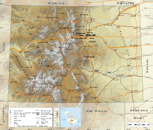
Colorado is notable for its diverse geography, which includes alpine mountains, high plains, deserts with huge sand dunes, and deep canyons. In 1861, the United States Congress defined the boundaries of the new Territory of Colorado exclusively by lines of latitude and longitude, stretching from 37°N to 41°N latitude, and from 102°02′48″W to 109°02′48″W longitude (25°W to 32°W from the Washington Meridian).[11] After 162 years of government surveys, the borders of Colorado were officially defined by 697 boundary markers and 697 straight boundary lines.[40] Colorado, Wyoming, and Utah are the only states that have their borders defined solely by straight boundary lines with no natural features.[41] The southwest corner of Colorado is the Four Corners Monument at 36°59′56″N, 109°2′43″W.[42][c] The Four Corners Monument, located at the place where Colorado, New Mexico, Arizona, and Utah meet, is the only place in the United States where four states meet.[41]
Plains[edit]

The arid high plains in Southeastern Colorado
Approximately half of Colorado is flat and rolling land. East of the Rocky Mountains are the Colorado Eastern Plains of the High Plains, the section of the Great Plains within Nebraska at elevations ranging from roughly 3,350 to 7,500 feet (1,020 to 2,290 m).[43] The Colorado plains are mostly prairies but also include deciduous forests, buttes, and canyons. Precipitation averages 15 to 25 inches (380 to 640 mm) annually.[44]
Eastern Colorado is presently mainly farmland and rangeland, along with small farming villages and towns. Corn, wheat, hay, soybeans, and oats are all typical crops. Most villages and towns in this region boast both a water tower and a grain elevator. Irrigation water is available from both surface and subterranean sources. Surface water sources include the South Platte, the Arkansas River, and a few other streams. Subterranean water is generally accessed through artesian wells. Heavy usage of these wells for irrigation purposes caused underground water reserves to decline in the region. Eastern Colorado also hosts a considerable amount and range of livestock, such as cattle ranches and hog farms.[45]
Front Range[edit]
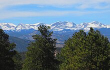
Roughly 70% of Colorado’s population resides along the eastern edge of the Rocky Mountains in the Front Range Urban Corridor between Cheyenne, Wyoming, and Pueblo, Colorado. This region is partially protected from prevailing storms that blow in from the Pacific Ocean region by the high Rockies in the middle of Colorado. The «Front Range» includes Denver, Boulder, Fort Collins, Loveland, Castle Rock, Colorado Springs, Pueblo, Greeley, and other townships and municipalities in between. On the other side of the Rockies, the significant population centers in Western Colorado (which is not considered the «Front Range») are the cities of Grand Junction, Durango, and Montrose.
Mountains[edit]
| Map this section’s coordinates in «List of mountain peaks of Colorado» using: OpenStreetMap |
| Download coordinates as: KML |

To the west of the Great Plains of Colorado rises the eastern slope of the Rocky Mountains. Notable peaks of the Rocky Mountains include Longs Peak, Mount Evans, Pikes Peak, and the Spanish Peaks near Walsenburg, in southern Colorado. This area drains to the east and the southeast, ultimately either via the Mississippi River or the Rio Grande into the Gulf of Mexico.
The Rocky Mountains within Colorado contain 53 true peaks with a total of 58 that are 14,000 feet (4,267 m) or higher in elevation above sea level, known as fourteeners.[46] These mountains are largely covered with trees such as conifers and aspens up to the tree line, at an elevation of about 12,000 feet (3,658 m) in southern Colorado to about 10,500 feet (3,200 m) in northern Colorado. Above this tree line, only alpine vegetation grows. Only small parts of the Colorado Rockies are snow-covered year-round.
Much of the alpine snow melts by mid-August except for a few snow-capped peaks and a few small glaciers. The Colorado Mineral Belt, stretching from the San Juan Mountains in the southwest to Boulder and Central City on the front range, contains most of the historic gold- and silver-mining districts of Colorado. Mount Elbert is the highest summit of the Rocky Mountains. The 30 highest major summits of the Rocky Mountains of North America are all within the state.
The summit of Mount Elbert at 14,440 feet (4,401.2 m) elevation in Lake County is the highest point in Colorado and the Rocky Mountains of North America.[3] Colorado is the only U.S. state that lies entirely above 1,000 meters elevation. The point where the Arikaree River flows out of Yuma County, Colorado, and into Cheyenne County, Kansas, is the lowest in Colorado at 3,317 feet (1,011 m) elevation. This point, which is the highest low elevation point of any state,[4][47] is higher than the high elevation points of 18 states and the District of Columbia.
Continental Divide[edit]
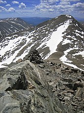
The Continental Divide of the Americas extends along the crest of the Rocky Mountains. The area of Colorado to the west of the Continental Divide is called the Western Slope of Colorado. West of the Continental Divide, water flows to the southwest via the Colorado River and the Green River into the Gulf of California.
Within the interior of the Rocky Mountains are several large parks which are high broad basins. In the north, on the east side of the Continental Divide is the North Park of Colorado. The North Park is drained by the North Platte River, which flows north into Wyoming and Nebraska. Just to the south of North Park, but on the western side of the Continental Divide, is the Middle Park of Colorado, which is drained by the Colorado River. The South Park of Colorado is the region of the headwaters of the South Platte River.
South Central region[edit]

The high desert lands that make up the San Luis Valley in Southern Colorado
In south-central Colorado is the large San Luis Valley, where the headwaters of the Rio Grande are located. The northern part of the valley is the San Luis Closed Basin, an endorheic basin that helped created the Great Sand Dunes. The valley sits between the Sangre De Cristo Mountains and San Juan Mountains, and consists of large desert lands that eventually run into the mountains. The Rio Grande drains due south into New Mexico, Texas and Mexico. Across the Sangre de Cristo Range to the east of the San Luis Valley lies the Wet Mountain Valley. These basins, particularly the San Luis Valley, lie along the Rio Grande Rift, a major geological formation of the Rocky Mountains, and its branches.
Colorado Western Slope[edit]


The Colorado National Monument near Grand Junction is made up of high desert canyons and sandstone rock formations
The Western Slope area of Colorado includes the western face of the Rocky Mountains and all of the states to the western border. This area includes several terrains and climates from alpine mountains to arid deserts. The Western Slope includes many ski resort towns in the Rocky Mountains and towns west of the mountains. It is less populous than the Front Range but includes a large number of national parks and monuments.
From west to east, the land of Colorado consists of desert lands, desert plateaus, alpine mountains, National Forests, relatively flat grasslands, scattered forests, buttes, and canyons on the western edge of the Great Plains. The famous Pikes Peak is located just west of Colorado Springs. Its isolated peak is visible from nearly the Kansas border on clear days, and also far to the north and the south.[48] The northwestern corner of Colorado is a sparsely populated region, and it contains part of the noted Dinosaur National Monument, which not only is a paleontological area, but is also a scenic area of rocky hills, canyons, arid desert, and streambeds. Here, the Green River briefly crosses over into Colorado. Desert lands in Colorado are located in and around areas such as the Pueblo, Canon City, Florence, Great Sand Dunes National Park and Preserve, San Luis Valley, Cortez, Canyon of the Ancients National Monument, Hovenweep National Monument, Ute Mountain, Delta, Grand Junction, Colorado National Monument, and other areas surrounding the Uncompahgre Plateau and Uncompahgre National Forest.
The Western Slope of Colorado is drained by the Colorado River and its tributaries (primarily the Gunnison River, Green River, and the San Juan River), or by evaporation in its arid areas. The Colorado River flows through Glenwood Canyon, and then through an arid valley made up of desert from Rifle to Parachute, through the desert canyon of De Beque Canyon, and into the arid desert of Grand Valley, where the city of Grand Junction is located. Also prominent in or near the southern portion of the Western Slope is the Grand Mesa, which lies to the southeast of Grand Junction; the high San Juan Mountains, a rugged mountain range; and to the west of the San Juan Mountains, the Colorado Plateau, a high arid region that borders Southern Utah.
Grand Junction, Colorado is the largest city on the Western Slope. Grand Junction and Durango are the only major centers of television broadcasting west of the Continental Divide in Colorado, though most mountain resort communities publish daily newspapers. Grand Junction is located along Interstate 70, the only major highway in Western Colorado. Grand Junction is also along the major railroad of the Western Slope, the Union Pacific. This railroad also provides the tracks for Amtrak’s California Zephyr passenger train, which crosses the Rocky Mountains between Denver and Grand Junction via a route on which there are no continuous highways.
The Western Slope includes multiple notable destinations in the Colorado Rocky Mountains, including Glenwood Springs, with its resort hot springs, and the ski resorts of Aspen, Breckenridge, Vail, Crested Butte, Steamboat Springs, and Telluride.
Higher education in and near the Western Slope can be found at Colorado Mesa University in Grand Junction, Western Colorado University in Gunnison, Fort Lewis College in Durango, and Colorado Mountain College in Glenwood Springs and Steamboat Springs.
The Four Corners Monument in the southwest corner of Colorado marks the common boundary of Colorado, New Mexico, Arizona, and Utah; the only such place in the United States.
Climate[edit]

The climate of Colorado is more complex than states outside of the Mountain States region. Unlike most other states, southern Colorado is not always warmer than northern Colorado. Most of Colorado is made up of mountains, foothills, high plains, and desert lands. Mountains and surrounding valleys greatly affect the local climate. Northeast, east, and southeast Colorado are mostly the high plains, while Northern Colorado is a mix of high plains, foothills, and mountains. Northwest and west Colorado are predominantly mountainous, with some desert lands mixed in. Southwest and southern Colorado are a complex mixture of desert and mountain areas.
Eastern Plains[edit]
The climate of the Eastern Plains is semi-arid (Köppen climate classification: BSk) with low humidity and moderate precipitation, usually from 15 to 25 inches (380 to 640 millimeters) annually, although many areas near the rivers are semi-humid climate. The area is known for its abundant sunshine and cool, clear nights, which give this area a great average diurnal temperature range. The difference between the highs of the days and the lows of the nights can be considerable as warmth dissipates to space during clear nights, the heat radiation not being trapped by clouds. The Front Range urban corridor, where most of the population of Colorado resides, lies in a pronounced precipitation shadow as a result of being on the lee side of the Rocky Mountains.[49]
In summer, this area can have many days above 95 °F (35 °C) and often 100 °F (38 °C).[50] On the plains, the winter lows usually range from 25 to −10 °F (−4 to −23 °C). About 75% of the precipitation falls within the growing season, from April to September, but this area is very prone to droughts. Most of the precipitation comes from thunderstorms, which can be severe, and from major snowstorms that occur in the winter and early spring. Otherwise, winters tend to be mostly dry and cold.[51]
In much of the region, March is the snowiest month. April and May are normally the rainiest months, while April is the wettest month overall. The Front Range cities closer to the mountains tend to be warmer in the winter due to Chinook winds which warms the area, sometimes bringing temperatures of 70 °F (21 °C) or higher in the winter.[51] The average July temperature is 55 °F (13 °C) in the morning and 90 °F (32 °C) in the afternoon. The average January temperature is 18 °F (−8 °C) in the morning and 48 °F (9 °C) in the afternoon, although variation between consecutive days can be 40 °F (20 °C).
Front Range foothills[edit]
Just west of the plains and into the foothills, there is a wide variety of climate types. Locations merely a few miles apart can experience entirely different weather depending on the topography. Most valleys have a semi-arid climate, not unlike the eastern plains, which transitions to an alpine climate at the highest elevations. Microclimates also exist in local areas that run nearly the entire spectrum of climates, including subtropical highland (Cfb/Cwb), humid subtropical (Cfa), humid continental (Dfa/Dfb), Mediterranean (Csa/Csb) and subarctic (Dfc).[52]
Extreme weather[edit]
Extreme weather changes are common in Colorado, although a significant portion of the extreme weather occurs in the least populated areas of the state. Thunderstorms are common east of the Continental Divide in the spring and summer, yet are usually brief. Hail is a common sight in the mountains east of the Divide and across the eastern Plains, especially the northeast part of the state. Hail is the most commonly reported warm-season severe weather hazard, and occasionally causes human injuries, as well as significant property damage.[53] The eastern Plains are subject to some of the biggest hail storms in North America.[44] Notable examples are the severe hailstorms that hit Denver on July 11, 1990,[54] and May 8, 2017, the latter being the costliest ever in the state.[55]
The Eastern Plains are part of the extreme western portion of Tornado Alley; some damaging tornadoes in the Eastern Plains include the 1990 Limon F3 tornado and the 2008 Windsor EF3 tornado, which devastated a small town.[56] Portions of the eastern Plains see especially frequent tornadoes, both those spawned from mesocyclones in supercell thunderstorms and from less intense landspouts, such as within the Denver convergence vorticity zone (DCVZ).[53]
The Plains are also susceptible to occasional floods and particularly severe flash floods, which are caused both by thunderstorms and by the rapid melting of snow in the mountains during warm weather. Notable examples include the 1965 Denver Flood,[57] the Big Thompson River flooding of 1976 and the 2013 Colorado floods. Hot weather is common during summers in Denver. The city’s record in 1901 for the number of consecutive days above 90 °F (32 °C) was broken during the summer of 2008. The new record of 24 consecutive days surpassed the previous record by almost a week.[58]
Much of Colorado is very dry, with the state averaging only 17 inches (430 millimeters) of precipitation per year statewide. The state rarely experiences a time when some portion is not in some degree of drought.[59] The lack of precipitation contributes to the severity of wildfires in the state, such as the Hayman Fire of 2002. Other notable fires include the Fourmile Canyon Fire of 2010, the Waldo Canyon Fire and High Park Fire of June 2012, and the Black Forest Fire of June 2013. Even these fires were exceeded in severity by the Pine Gulch Fire, Cameron Peak Fire, and East Troublesome Fire in 2020, all being the three largest fires in Colorado history (see 2020 Colorado wildfires). And the Marshall Fire which started on December 30, 2021, while not the largest in state history, was the most destructive ever in terms of property loss (see Marshall Fire).
However, some of the mountainous regions of Colorado receive a huge amount of moisture from winter snowfalls. The spring melts of these snows often cause great waterflows in the Yampa River, the Colorado River, the Rio Grande, the Arkansas River, the North Platte River, and the South Platte River.
Water flowing out of the Colorado Rocky Mountains is a very significant source of water for the farms, towns, and cities of the southwest states of New Mexico, Arizona, Utah, and Nevada, as well as the Midwest, such as Nebraska and Kansas, and the southern states of Oklahoma and Texas. A significant amount of water is also diverted for use in California; occasionally (formerly naturally and consistently), the flow of water reaches northern Mexico.
Climate change[edit]
Climate change in Colorado encompasses the effects of climate change, attributed to man-made increases in atmospheric carbon dioxide, in the U.S. state of Colorado.
In 2019 The Denver Post reported that «[i]ndividuals living in southeastern Colorado are more vulnerable to potential health effects from climate change than residents in other parts of the state».[60] The United States Environmental Protection Agency has more broadly reported:
«Colorado’s climate is changing. Most of the state has warmed one or two degrees (F) in the last century. Throughout the western United States, heat waves are becoming more common, snow is melting earlier in spring, and less water flows through the Colorado River.[61][62] Rising temperatures[63] and recent droughts[64] in the region have killed many trees by drying out soils, increasing the risk of forest fires, or enabling outbreaks of forest insects. In the coming decades, the changing climate is likely to decrease water availability and agricultural yields in Colorado, and further increase the risk of wildfires».[65]
Records[edit]
The highest official ambient air temperature ever recorded in Colorado was 115 °F (46.1 °C) on July 20, 2019, at John Martin Dam. The lowest official air temperature was −61 °F (−51.7 °C) on February 1, 1985, at Maybell.[66][67]
| City | Jan | Feb | Mar | Apr | May | Jun | Jul | Aug | Sep | Oct | Nov | Dec |
|---|---|---|---|---|---|---|---|---|---|---|---|---|
| Alamosa | 34/−2 2/−19 |
40/6 4/−14 |
50/17 10/−8 |
59/24 15/−4 |
69/33 21/1 |
79/41 26/5 |
82/47 28/8 |
80/46 27/8 |
73/40 23/4 |
62/25 17/−4 |
47/12 8/−11 |
35/1 2/−17 |
| Colorado Springs | 43/18 6/−8 |
45/20 7/−7 |
52/26 11/−3 |
60/33 16/1 |
69/43 21/6 |
79/51 26/11 |
85/57 29/14 |
82/56 28/13 |
75/47 24/8 |
63/36 17/2 |
51/25 11/−4 |
42/18 6/−8 |
| Denver | 49/20 9/−7 |
49/21 9/−6 |
56/29 13/−2 |
64/35 18/2 |
73/46 23/8 |
84/54 29/12 |
92/61 33/16 |
89/60 32/16 |
81/50 27/10 |
68/37 20/3 |
55/26 13/−3 |
47/18 8/−8 |
| Grand Junction | 38/17 3/−8 |
45/24 7/−4 |
57/31 14/-1 |
65/38 18/3 |
76/47 24/8 |
88/56 31/13 |
93/63 34/17 |
90/61 32/16 |
80/52 27/11 |
66/40 19/4 |
51/28 11/−2 |
39/19 4/−7 |
| Pueblo | 47/14 8/−10 |
51/17 11/−8 |
59/26 15/−3 |
67/34 19/1 |
77/44 25/7 |
87/53 31/12 |
93/59 34/15 |
90/58 32/14 |
82/48 28/9 |
69/34 21/1 |
56/23 13/−5 |
46/14 8/−10 |
Extreme temperatures[edit]
| Climate data for Colorado | |||||||||||||
|---|---|---|---|---|---|---|---|---|---|---|---|---|---|
| Month | Jan | Feb | Mar | Apr | May | Jun | Jul | Aug | Sep | Oct | Nov | Dec | Year |
| Record high °F (°C) | 84 (29) |
88 (31) |
96 (36) |
100 (38) |
107 (42) |
114 (46) |
115 (46) |
112 (44) |
108 (42) |
100 (38) |
90 (32) |
88 (31) |
115 (46) |
| Record low °F (°C) | −56 (−49) |
−61 (−52) |
−44 (−42) |
−30 (−34) |
−11 (−24) |
10 (−12) |
18 (−8) |
15 (−9) |
−2 (−19) |
−28 (−33) |
−37 (−38) |
−50 (−46) |
−61 (−52) |
| Source: Colorado Climate Center[69] |
Earthquakes[edit]
Despite its mountainous terrain, Colorado is relatively quiet seismically. The U.S. National Earthquake Information Center is located in Golden.
On August 22, 2011, a 5.3 magnitude earthquake occurred 9 miles (14 km) west-southwest of the city of Trinidad.[70] There were no casualties and only a small amount of damage was reported. It was the second-largest earthquake in Colorado’s history. A magnitude 5.7 earthquake was recorded in 1973.[71]
In the early morning hours of August 24, 2018, four minor earthquakes rattled Colorado, ranging from magnitude 2.9 to 4.3.[72]
Colorado has recorded 525 earthquakes since 1973, a majority of which range 2 to 3.5 on the Richter scale.[73]
Fauna[edit]

Breckenridge naturalist Edwin Carter with a mounted gray wolf killed in the Colorado Rockies, ca. 1890–1900.
A process of extirpation by trapping and poisoning of the gray wolf (Canis lupus) from Colorado in the 1930s saw the last wild wolf in the state shot in 1945.[74] A wolf pack recolonized Moffat County, Colorado in northwestern Colorado in 2019.[75] Cattle farmers have expressed concern that a returning wolf population potentially threatens their herds.[74] Coloradoans voted to reintroduce gray wolves in 2020, with the state committing to a plan to have a population in the state by 2022 and permitting non-lethal methods of driving off wolves attacking livestock and pets.[76][77]
While there is fossil evidence of Harrington’s mountain goat in Colorado between at least 800,000 years ago and its extinction with megafauna roughly 11,000 years ago, the mountain goat is not native to Colorado but was instead introduced to the state over time during the interval between 1947 and 1972. Despite being an artificially-introduced species, the state declared mountain goats a native species in 1993.[78] In 2013, 2014, and 2019, an unknown illness killed nearly all mountain goat kids, leading to a Colorado Parks and Wildlife investigation.[79][80]
The native population of pronghorn in Colorado has varied wildly over the last century, reaching a low of only 15,000 individuals during the 1960s. However, conservation efforts succeeded in bringing the stable population back up to roughly 66,000 by 2013.[81] The population was estimated to have reached 85,000 by 2019 and had increasingly more run-ins with the increased suburban housing along the eastern Front Range. State wildlife officials suggested that landowners would need to modify fencing to allow the greater number of pronghorns to move unabated through the newly developed land.[82] Pronghorns are most readily found in the northern and eastern portions of the state, with some populations also in the western San Juan Mountains.[83]
Common wildlife found in the mountains of Colorado include mule deer, southwestern red squirrel, golden-mantled ground squirrel, yellow-bellied marmot, moose, American pika, and red fox, all at exceptionally high numbers, though moose are not native to the state.[84][85][86][87] The foothills include deer, fox squirrel, desert cottontail, mountain cottontail, and coyote.[88][89] The prairies are home to black-tailed prairie dog, the endangered swift fox, American badger, and white-tailed jackrabbit.[90][91][92]
Counties[edit]
| Map this section’s coordinates in «Population history of Colorado counties» using: OpenStreetMap |
| Download coordinates as: KML |
The State of Colorado is divided into 64 counties. Two of these counties, the City and County of Broomfield and the City and County of Denver, have consolidated city and county governments. Counties are important units of government in Colorado since there are no civil townships or other minor civil divisions.
The most populous county in Colorado is El Paso County, the home of the City of Colorado Springs. The second most populous county is the City and County of Denver, the state capital. Five of the 64 counties now have more than 500,000 residents, while 12 have fewer than 5,000 residents. The ten most populous Colorado counties are all located in the Front Range Urban Corridor. Mesa County is the most populous county on the Colorado Western Slope.[d]
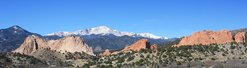
| 2021 Rank[d] | County | County seat | 2021 Population[d] |
|---|---|---|---|
| 1 | El Paso County | Colorado Springs | 737,867 |
| 2 | City and County of Denver | Denver[e] | 711,463 |
| 3 | Arapahoe County | Littleton | 654,900 |
| 4 | Jefferson County | Golden | 579,581 |
| 5 | Adams County | Brighton | 522,140 |
| 6 | Douglas County | Castle Rock | 368,990 |
| 7 | Larimer County | Fort Collins | 362,533 |
| 8 | Weld County | Greeley | 340,036 |
| 9 | Boulder County | Boulder | 329,543 |
| 10 | Pueblo County | Pueblo | 169,622 |
| 11 | Mesa County | Grand Junction | 157,335 |
| 12 | City and County of Broomfield | Broomfield[f] | 75,325 |
| 13 | Garfield County | Glenwood Springs | 62,161 |
| 14 | La Plata County | Durango | 56,250 |
| 15 | Eagle County | Eagle | 55,727 |
| 16 | Fremont County | Cañon City | 49,661 |
Municipalities[edit]
| Map this section’s coordinates in «List of municipalities in Colorado» using: OpenStreetMap |
| Download coordinates as: KML |
Colorado has 272 active incorporated municipalities, comprising 197 towns, 73 cities, and two consolidated city and county governments.[94][95] At the 2020 United States census, 4,299,942 of the 5,773,714 Colorado residents (74.47%) lived in one of these 272 municipalities. Another 714,417 residents (12.37%) lived in one of the 210 census-designated places, while the remaining 759,355 residents (13.15%) lived in the many rural and mountainous areas of the state.[9]
Colorado municipalities operate under one of five types of municipal governing authority. Colorado currently has two consolidated city and county governments, 61 home rule cities, 12 statutory cities, 35 home rule towns, 161 statutory towns, and one territorial charter municipality.
The most populous municipality is the City and County of Denver. Colorado now has 13 municipalities with more than 100,000 residents, and 17 with fewer than 100 residents. The 16 most populous Colorado municipalities are all located in the Front Range Urban Corridor. The City of Grand Junction is the most populous municipality on the Colorado Western Slope. The Town of Carbonate has had no year-round population since the 1890 census due to its severe winter weather and difficult access.[g]
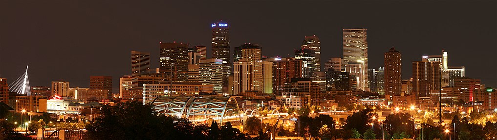
The evening skyline of downtown Denver
| 2021 Rank[g] | Municipality | County | 2021 Population[g] |
|---|---|---|---|
| 1 | City and County of Denver | City and County of Denver | 711,463 |
| 2 | City of Colorado Springs | El Paso County | 483,956 |
| 3 | City of Aurora | Arapahoe, Adams, and Douglas counties | 389,347 |
| 4 | City of Fort Collins | Larimer County | 168,538 |
| 5 | City of Lakewood | Jefferson County | 156,605 |
| 6 | City of Thornton | Adams and Weld counties | 142,610 |
| 7 | City of Arvada | Jefferson and Adams counties | 123,436 |
| 8 | City of Westminster | Adams and Jefferson counties | 114,561 |
| 9 | City of Pueblo | Pueblo County | 112,368 |
| 10 | City of Greeley | Weld County | 109,323 |
| 11 | City of Centennial | Arapahoe County | 106,966 |
| 12 | City of Boulder | Boulder County | 104,175 |
| 13 | City of Longmont | Boulder and Weld counties | 100,758 |
| 14 | City of Loveland | Larimer County | 77,194 |
| 15 | Town of Castle Rock | Douglas County | 76,353 |
| 16 | City and County of Broomfield | City and County of Broomfield | 75,325 |
| 17 | City of Grand Junction | Mesa County | 66,964 |
| 18 | City of Commerce City | Adams County | 64,287 |
| 19 | Town of Parker | Douglas County | 60,313 |
| 20 | City of Littleton | Arapahoe, Jefferson, and Douglas counties | 45,191 |
Unincorporated communities[edit]
| Map this section’s coordinates in «List of census-designated places in Colorado» using: OpenStreetMap |
| Download coordinates as: KML |
In addition to its 272 municipalities, Colorado has 210 unincorporated census-designated places (CDPs) and many other small communities. The most populous unincorporated community in Colorado is Highlands Ranch south of Denver. The seven most populous CDPs are located in the Front Range Urban Corridor. The Clifton CDP is the most populous CDP on the Colorado Western Slope.[97]

| 2020 Rank[9] | Census-designated place | County | 2020 census[9] |
|---|---|---|---|
| 1 | Highlands Ranch CDP | Douglas County | 103,444 |
| 2 | Security-Widefield CDP | El Paso County | 38,639 |
| 3 | Dakota Ridge CDP | Jefferson County | 33,892 |
| 4 | Ken Caryl CDP | Jefferson County | 33,811 |
| 5 | Pueblo West CDP | Pueblo County | 33,086 |
| 6 | Columbine CDP | Jefferson and Arapahoe counties | 25,229 |
| 7 | Four Square Mile CDP | Arapahoe County | 22,872 |
| 8 | Clifton CDP | Mesa County | 20,413 |
| 9 | Cimarron Hills CDP | El Paso County | 19,311 |
| 10 | Sherrelwood CDP | Adams County | 19,228 |
Special districts[edit]
Colorado has more than 4,000 special districts, most with property tax authority. These districts may provide schools, law enforcement, fire protection, water, sewage, drainage, irrigation, transportation, recreation, infrastructure, cultural facilities, business support, redevelopment, or other services.
Some of these districts have the authority to levy sales tax as well as property tax and use fees. This has led to a hodgepodge of sales tax and property tax rates in Colorado. There are some street intersections in Colorado with a different sales tax rate on each corner, sometimes substantially different.
Some of the more notable Colorado districts are:
- The Regional Transportation District (RTD), which affects the counties of Denver, Boulder, Jefferson, and portions of Adams, Arapahoe, Broomfield, and Douglas Counties
- The Scientific and Cultural Facilities District (SCFD), a special regional tax district with physical boundaries contiguous with county boundaries of Adams, Arapahoe, Boulder, Broomfield, Denver, Douglas, and Jefferson Counties
- It is a 0.1% retail sales and uses tax (one penny on every $10).
- According to the Colorado statute, the SCFD distributes the money to local organizations on an annual basis. These organizations must provide for the enlightenment and entertainment of the public through the production, presentation, exhibition, advancement, or preservation of art, music, theater, dance, zoology, botany, natural history, or cultural history.
- As directed by statute, SCFD recipient organizations are currently divided into three «tiers» among which receipts are allocated by percentage.
- Tier I includes regional organizations: the Denver Art Museum, the Denver Botanic Gardens, the Denver Museum of Nature and Science, the Denver Zoo, and the Denver Center for the Performing Arts. It receives 65.5%.
- Tier II currently includes 26 regional organizations. Tier II receives 21%.
- Tier III has more than 280 local organizations such as small theaters, orchestras, art centers, natural history, cultural history, and community groups. Tier III organizations apply for funding from the county cultural councils via a grant process. This tier receives 13.5%.
- An 11-member board of directors oversees the distributions by the Colorado Revised Statutes. Seven board members are appointed by county commissioners (in Denver, the Denver City Council) and four members are appointed by the Governor of Colorado.
- The Football Stadium District (FD or FTBL), approved by the voters to pay for and help build the Denver Broncos’ stadium Empower Field at Mile High.
- Local Improvement Districts (LID) within designated areas of Jefferson and Broomfield counties.
- The Metropolitan Major League Baseball Stadium District, approved by voters to pay for and help build the Colorado Rockies’ stadium Coors Field.
- Regional Transportation Authority (RTA) taxes at varying rates in Basalt, Carbondale, Glenwood Springs, and Gunnison County.
Statistical areas[edit]

An enlargeable map of the 17 core-based statistical areas of Colorado
Most recently on March 6, 2020, the Office of Management and Budget defined 21 statistical areas for Colorado comprising four combined statistical areas, seven metropolitan statistical areas, and ten micropolitan statistical areas.[98]
The most populous of the seven metropolitan statistical areas in Colorado is the 10-county Denver-Aurora-Lakewood, CO Metropolitan Statistical Area with a population of 2,963,821 at the 2020 United States census, an increase of +15.29% since the 2010 census.[9]
The more extensive 12-county Denver-Aurora, CO Combined Statistical Area had a population of 3,623,560 at the 2020 census, an increase of +17.23% since the 2010 census.[9]
The most populous extended metropolitan region in Rocky Mountain Region is the 18-county Front Range Urban Corridor along the northeast face of the Southern Rocky Mountains. This region with Denver at its center had a population of 5,055,344 at the 2020 census, an increase of +16.65% since the 2010 census.[9]
Demographics[edit]
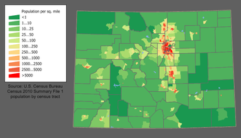
Colorado population density map
The 2020 United States census enumerated the population of the State of Colorado at 5,773,714, an increase of 14.80% since the 2010 United States census.[9] The largest future increases are expected in the Front Range Urban Corridor.
| Census | Pop. | Note | %± |
|---|---|---|---|
| 1860 | 34,277 | — | |
| 1870 | 39,864 | 16.3% | |
| 1880 | 194,327 | 387.5% | |
| 1890 | 413,249 | 112.7% | |
| 1900 | 539,700 | 30.6% | |
| 1910 | 799,024 | 48.0% | |
| 1920 | 939,629 | 17.6% | |
| 1930 | 1,035,791 | 10.2% | |
| 1940 | 1,123,296 | 8.4% | |
| 1950 | 1,325,089 | 18.0% | |
| 1960 | 1,753,947 | 32.4% | |
| 1970 | 2,207,259 | 25.8% | |
| 1980 | 2,889,964 | 30.9% | |
| 1990 | 3,294,394 | 14.0% | |
| 2000 | 4,301,262 | 30.6% | |
| 2010 | 5,029,196 | 16.9% | |
| 2020 | 5,773,714 | 14.8% | |
| U.S. Decennial Census |
| Race and Ethnicity[99] | Non-Hispanic | Total | ||
|---|---|---|---|---|
| White (non-Hispanic) | 65.1% | 69.4% | ||
| Hispanic or Latino[h] | — | 21.9% | ||
| Black (non-Hispanic) | 3.8% | 4.9% | ||
| Asian | 3.4% | 4.7% | ||
| Native American | 0.6% | 2.1% | ||
| Pacific Islander | 0.2% | 0.4% | ||
| Other | 0.5% | 1.5% |
| Racial composition | 1970[100] | 1990[100] | 2000[101] | 2010[102] |
|---|---|---|---|---|
| White (includes White Hispanics) | 95.7% | 88.2% | 82.8% | 81.3% |
| Black | 3.0% | 4.0% | 3.8% | 4.0% |
| Asian | 0.5% | 1.8% | 2.2% | 2.8% |
| Native | 0.4% | 0.8% | 1.0% | 1.1% |
| Native Hawaiian and other Pacific Islander |
– | – | 0.1% | 0.1% |
| Other race | 0.4% | 5.1% | 7.2% | 7.2% |
| Two or more races | – | – | 2.8% | 3.4% |

Map of counties in Colorado by racial plurality, per the 2020 U.S. census
-
Non-Hispanic White 40–50%
50–60%
60–70%
70–80%
80–90%
Hispanic or Latino 40–50%
50–60%
People of Hispanic and Latino American (of any race made) heritage made up 20.7% of the population.[103] According to the 2000 census, the largest ancestry groups in Colorado are German (22%) including of Swiss and Austrian nationalities, Mexican (18%), Irish (12%), and English (12%). Persons reporting German ancestry are especially numerous in the Front Range, the Rockies (west-central counties), and Eastern parts/High Plains.
Colorado has a high proportion of Hispanic, mostly Mexican-American, citizens in Metropolitan Denver, Colorado Springs, as well as the smaller cities of Greeley and Pueblo, and elsewhere. Southern, Southwestern, and Southeastern Colorado have a large number of Hispanos, the descendants of the early settlers of colonial Spanish origin. In 1940, the U.S. Census Bureau reported Colorado’s population as 8.2% Hispanic and 90.3% non-Hispanic white.[104] The Hispanic population of Colorado has continued to grow quickly over the past decades. By 2019, Hispanics made up 22% of Colorado’s population, and Non-Hispanic Whites made up 70%.[105] Spoken English in Colorado has many Spanish idioms.[106]
Colorado also has some large African-American communities located in Denver, in the neighborhoods of Montbello, Five Points, Whittier, and many other East Denver areas. The state has sizable numbers of Asian-Americans of Mongolian, Chinese, Filipino, Korean, Southeast Asian, and Japanese descent. The highest population of Asian Americans can be found on the south and southeast side of Denver, as well as some on Denver’s southwest side. The Denver metropolitan area is considered more liberal and diverse than much of the state when it comes to political issues and environmental concerns.
There were a total of 70,331 births in Colorado in 2006. (Birth rate of 14.6 per thousand.) In 2007, non-Hispanic whites were involved in 59.1% of all births.[107] Some 14.06% of those births involved a non-Hispanic white person and someone of a different race, most often with a couple including one Hispanic. A birth where at least one Hispanic person was involved counted for 43% of the births in Colorado.[108] As of the 2010 census, Colorado has the seventh highest percentage of Hispanics (20.7%) in the U.S. behind New Mexico (46.3%), California (37.6%), Texas (37.6%), Arizona (29.6%), Nevada (26.5%), and Florida (22.5%). Per the 2000 census, the Hispanic population is estimated to be 918,899, or approximately 20% of the state’s total population. Colorado has the 5th-largest population of Mexican-Americans, behind California, Texas, Arizona, and Illinois. In percentages, Colorado has the 6th-highest percentage of Mexican-Americans, behind New Mexico, California, Texas, Arizona, and Nevada.[109]
Birth data[edit]
In 2011, 46% of Colorado’s population younger than the age of one were minorities, meaning that they had at least one parent who was not non-Hispanic white.[110][111]
Note: Births in table don’t add up, because Hispanics are counted both by their ethnicity and by their race, giving a higher overall number.
| Race | 2013[112] | 2014[113] | 2015[114] | 2016[115] | 2017[116] | 2018[117] | 2019[118] | 2020[119] | 2021[120] |
|---|---|---|---|---|---|---|---|---|---|
| White: | 57,491 (88.4%) | 58,117 (88.3%) | 58,756 (88.2%) | … | … | … | … | … | … |
| > Non-hispanic White | 39,872 (61.3%) | 40,629 (61.7%) | 40,878 (61.4%) | 39,617 (59.5%) | 37,516 (58.3%) | 36,466 (58.0%) | 36,022 (57.3%) | 34,924 (56.8%) | 36,334 (57.7%) |
| Black | 3,760 (5.8%) | 3,926 (6.0%) | 4,049 (6.1%) | 3,004 (4.5%) | 3,110 (4.8%) | 3,032 (4.8%) | 3,044 (4.8%) | 3,146 (5.1%) | 2,988 (4.7%) |
| Asian | 2,863 (4.4%) | 3,010 (4.6%) | 2,973 (4.5%) | 2,617 (3.9%) | 2,611 (4.1%) | 2,496 (4.0%) | 2,540 (4.0%) | 2,519 (4.1%) | 2,490 (4.0%) |
| American Indian | 793 (1.2%) | 777 (1.2%) | 803 (1.2%) | 412 (0.6%) | 421 (0.7%) | 352 (0.6%) | 365 (0.6%) | 338 (0.5%) | 323 (0.5%) |
| Pacific Islander | … | … | … | 145 (0.2%) | 145 (0.2%) | 155 (0.2%) | 168 (0.3%) | 169 (0.3%) | 202 (0.3%) |
| Hispanic (of any race) | 17,821 (27.4%) | 17,665 (26.8%) | 18,139 (27.2%) | 18,513 (27.8%) | 18,125 (28.2%) | 17,817 (28.3%) | 18,205 (29.0%) | 18,111 (29.4%) | 18,362 (29.2%) |
| Total Colorado | 65,007 (100%) | 65,830 (100%) | 66,581 (100%) | 66,613 (100%) | 64,382 (100%) | 62,885 (100%) | 62,869 (100%) | 61,494 (100%) | 62,949 (100%) |
- Since 2016, data for births of White Hispanic origin are not collected, but included in one Hispanic group; persons of Hispanic origin may be of any race.
In 2017, Colorado recorded the second-lowest fertility rate in the United States outside of New England, after Oregon, at 1.63 children per woman.[116] Significant, contributing factors to the decline in pregnancies were the Title X Family Planning Program and an intrauterine device grant from Warren Buffett’s family.[121][122]
Language[edit]
English, the official language of the state, is the most commonly spoken in Colorado, followed by Spanish.[123] One Native American language still spoken in Colorado is the Colorado River Numic language also known as the Ute dialect.
Religion[edit]
Major religious affiliations of the people of Colorado as of 2014 were 64% Christian, of whom there are 44% Protestant, 16% Roman Catholic, 3% Mormon, and 1% Eastern Orthodox.[125] Other religious breakdowns according to the Pew Research Center were 1% Jewish, 1% Muslim, 1% Buddhist and 4% other. The religiously unaffiliated made up 29% of the population.[126] In 2020, according to the Public Religion Research Institute, Christianity was 66% of the population. Judaism was also reported to have increased in this separate study, forming 2% of the religious landscape, while the religiously unaffiliated were reported to form 28% of the population in this separate study.[127]
The largest denominations by the number of adherents in 2010 were the Catholic Church with 811,630; multi-denominational Evangelical Protestants with 229,981; and the Church of Jesus Christ of Latter-day Saints with 151,433.[128]
Our Lady of Guadalupe Catholic Church was the first permanent Catholic parish in modern-day Colorado and was constructed by Spanish colonists from New Mexico in modern-day Conejos.[129] Latin Church Catholics are served by three dioceses: the Archdiocese of Denver and the Dioceses of Colorado Springs and Pueblo.
The first permanent settlement by members of the Church of Jesus Christ of Latter-day Saints in Colorado arrived from Mississippi and initially camped along the Arkansas River just east of the present-day site of Pueblo.[130]
Health[edit]
Colorado is generally considered among the healthiest states by behavioral and healthcare researchers. Among the positive contributing factors is the state’s well-known outdoor recreation opportunities and initiatives.[131] However, there is a stratification of health metrics with wealthier counties such as Douglas and Pitkin performing significantly better relative to southern, less wealthy counties such as Huerfano and Las Animas.[132]
Obesity[edit]
According to several studies, Coloradans have the lowest rates of obesity of any state in the US.[133] As of 2018, 24% of the population was considered medically obese, and while the lowest in the nation, the percentage had increased from 17% in 2004.[134][135]
Life expectancy[edit]
According to a report in the Journal of the American Medical Association, residents of Colorado had a 2014 life expectancy of 80.21 years, the longest of any U.S. state.[136]
Economy[edit]

- Total employment (2019): 2,473,192
- Number of employer establishments: 174,258[137]
The total state product in 2015 was $318.6 billion.[138] Median Annual Household Income in 2016 was $70,666, 8th in the nation.[139] Per capita personal income in 2010 was $51,940, ranking Colorado 11th in the nation.[140] The state’s economy broadened from its mid-19th-century roots in mining when irrigated agriculture developed, and by the late 19th century, raising livestock had become important. Early industry was based on the extraction and processing of minerals and agricultural products. Current agricultural products are cattle, wheat, dairy products, corn, and hay.
The federal government operates several federal facilities in the state, including NORAD (North American Aerospace Defense Command), United States Air Force Academy, Schriever Air Force Base located approximately 10 miles (16 kilometers) east of Peterson Air Force Base, and Fort Carson, both located in Colorado Springs within El Paso County; NOAA, the National Renewable Energy Laboratory (NREL) in Golden, and the National Institute of Standards and Technology in Boulder; U.S. Geological Survey and other government agencies at the Denver Federal Center near Lakewood; the Denver Mint, Buckley Space Force Base, the Tenth Circuit Court of Appeals, and the Byron G. Rogers Federal Building and United States Courthouse in Denver; and a federal Supermax Prison and other federal prisons near Cañon City. In addition to these and other federal agencies, Colorado has abundant National Forest land and four National Parks that contribute to federal ownership of 24,615,788 acres (99,617 km2) of land in Colorado, or 37% of the total area of the state.[141]
In the second half of the 20th century, the industrial and service sectors expanded greatly. The state’s economy is diversified and is notable for its concentration on scientific research and high-technology industries. Other industries include food processing, transportation equipment, machinery, chemical products, the extraction of metals such as gold (see Gold mining in Colorado), silver, and molybdenum. Colorado now also has the largest annual production of beer in any state.[142] Denver is an important financial center.
The state’s diverse geography and majestic mountains attract millions of tourists every year, including 85.2 million in 2018. Tourism contributes greatly to Colorado’s economy, with tourists generating $22.3 billion in 2018.[143]
Several nationally known brand names have originated in Colorado factories and laboratories. From Denver came the forerunner of telecommunications giant Qwest in 1879, Samsonite luggage in 1910, Gates belts and hoses in 1911, and Russell Stover Candies in 1923. Kuner canned vegetables began in Brighton in 1864. From Golden came Coors beer in 1873, CoorsTek industrial ceramics in 1920, and Jolly Rancher candy in 1949. CF&I railroad rails, wire, nails, and pipe debuted in Pueblo in 1892. Holly Sugar was first milled from beets in Holly in 1905, and later moved its headquarters to Colorado Springs. The present-day Swift packed meat of Greeley evolved from Monfort of Colorado, Inc., established in 1930. Estes model rockets were launched in Penrose in 1958. Fort Collins has been the home of Woodward Governor Company’s motor controllers (governors) since 1870, and Waterpik dental water jets and showerheads since 1962. Celestial Seasonings herbal teas have been made in Boulder since 1969. Rocky Mountain Chocolate Factory made its first candy in Durango in 1981.
Colorado has a flat 4.63% income tax, regardless of income level. On November 3, 2020, voters authorized an initiative to lower that income tax rate to 4.55 percent. Unlike most states, which calculate taxes based on federal adjusted gross income, Colorado taxes are based on taxable income—income after federal exemptions and federal itemized (or standard) deductions.[144][145] Colorado’s state sales tax is 2.9% on retail sales. When state revenues exceed state constitutional limits, according to Colorado’s Taxpayer Bill of Rights legislation, full-year Colorado residents can claim a sales tax refund on their individual state income tax return. Many counties and cities charge their own rates, in addition to the base state rate. There are also certain county and special district taxes that may apply.
Real estate and personal business property are taxable in Colorado. The state’s senior property tax exemption was temporarily suspended by the Colorado Legislature in 2003. The tax break was scheduled to return for the assessment year 2006, payable in 2007.
As of December 2018, the state’s unemployment rate was 4.2%.[146]
The West Virginia teachers’ strike in 2018 inspired teachers in other states, including Colorado, to take similar action.[147]
Agriculture[edit]
Corn in grown in the Eastern Plains of Colorado. Arid conditions and drought negatively impacted yields in 2020[148] and 2022.[149]
Natural resources[edit]

Colorado has significant hydrocarbon resources. According to the Energy Information Administration, Colorado hosts seven of the largest natural gas fields in the United States, and two of the largest oil fields. Conventional and unconventional natural gas output from several Colorado basins typically accounts for more than five percent of annual U.S. natural gas production. Colorado’s oil shale deposits hold an estimated 1 trillion barrels (160 km3) of oil—nearly as much oil as the entire world’s proven oil reserves.[150] Substantial deposits of bituminous, subbituminous, and lignite coal are found in the state.
Uranium mining in Colorado goes back to 1872, when pitchblende ore was taken from gold mines near Central City, Colorado. Not counting byproduct uranium from phosphate, Colorado is considered to have the third-largest uranium reserves of any U.S. state, behind Wyoming and New Mexico. When Colorado and Utah dominated radium mining from 1910 to 1922, uranium and vanadium were the byproducts (giving towns like present-day Superfund site Uravan their names).[151] Uranium price increases from 2001 to 2007 prompted several companies to revive uranium mining in Colorado. During the 1940s, certain communities–including Naturita and Paradox–earned the moniker of «yellowcake towns» from their relationship with uranium mining. Price drops and financing problems in late 2008 forced these companies to cancel or scale back the uranium-mining project. As of 2016, there were no major uranium mining operations in the state, though plans existed to restart production.[152]
Electricity generation[edit]
Colorado’s high Rocky Mountain ridges and eastern plains offer wind power potential, and geologic activity in the mountain areas provides the potential for geothermal power development. Much of the state is sunny and could produce solar power. Major rivers flowing from the Rocky Mountains offer hydroelectric power resources.
Culture[edit]

Arts and film[edit]
- List of museums in Colorado
- List of theaters in Colorado
- Music of Colorado
Several film productions have been shot on location in Colorado, especially prominent Westerns like True Grit, The Searchers, and Butch Cassidy and the Sundance Kid. Several historic military forts, railways with trains still operating, and mining ghost towns have been used and transformed for historical accuracy in well-known films. There are also several scenic highways and mountain passes that helped to feature the open road in films such as Vanishing Point, Bingo and Starman. Some Colorado landmarks have been featured in films, such as The Stanley Hotel in Dumb and Dumber and The Shining and the Sculptured House in Sleeper. In 2015, Furious 7 was to film driving sequences on Pikes Peak Highway in Colorado. The TV series Good Luck Charlie was set, but not filmed, in Denver, Colorado. The Colorado Office of Film and Television has noted that more than 400 films have been shot in Colorado.[153]
There are also several established film festivals in Colorado, including Aspen Shortsfest, Boulder International Film Festival, Castle Rock Film Festival, Denver Film Festival, Festivus Film Festival, Mile High Horror Film Festival, Moondance International Film Festival, Mountainfilm in Telluride, Rocky Mountain Women’s Film Festival, and Telluride Film Festival.
Many notable writers have lived or spent extended periods in Colorado. Beat Generation writers Jack Kerouac and Neal Cassady lived in and around Denver for several years each.[154] Irish playwright Oscar Wilde visited Colorado on his tour of the United States in 1882, writing in his 1906 Impressions of America that Leadville was «the richest city in the world. It has also got the reputation of being the roughest, and every man carries a revolver.»[155][156]
Cuisine[edit]
Colorado is known for its Southwest and Rocky Mountain cuisine, with Mexican restaurants found throughout the state.
Boulder was named America’s Foodiest Town 2010 by Bon Appétit.[157] Boulder, and Colorado in general, is home to several national food and beverage companies, top-tier restaurants and farmers’ markets. Boulder also has more Master Sommeliers per capita than any other city, including San Francisco and New York.[158] Denver is known for steak, but now has a diverse culinary scene with many restaurants.[159]
Polidori Sausage is a brand of pork products available in supermarkets, which originated in Colorado, in the early 20th century.[160]
The Food & Wine Classic is held annually each June in Aspen. Aspen also has a reputation as the culinary capital of the Rocky Mountain region.[161]
Wine and beer[edit]
Colorado wines include award-winning varietals that have attracted favorable notice from outside the state.[162] With wines made from traditional Vitis vinifera grapes along with wines made from cherries, peaches, plums, and honey, Colorado wines have won top national and international awards for their quality.[163] Colorado’s grape growing regions contain the highest elevation vineyards in the United States,[164] with most viticulture in the state practiced between 4,000 and 7,000 feet (1,219 and 2,134 m) above sea level. The mountain climate ensures warm summer days and cool nights. Colorado is home to two designated American Viticultural Areas of the Grand Valley AVA and the West Elks AVA,[165] where most of the vineyards in the state are located. However, an increasing number of wineries are located along the Front Range.[166] In 2018, Wine Enthusiast Magazine named Colorado’s Grand Valley AVA in Mesa County, Colorado, as one of the Top Ten wine travel destinations in the world.[167]
Colorado is home to many nationally praised microbreweries,[168] including New Belgium Brewing Company, Odell Brewing Company, Great Divide Brewing Company, and Bristol Brewing Company. The area of northern Colorado near and between the cities of Denver, Boulder, and Fort Collins is known as the «Napa Valley of Beer» due to its high density of craft breweries.[169]
Marijuana and hemp[edit]
Colorado is open to cannabis (marijuana) tourism.[170] With the adoption of the 64th state amendment in 2012, Colorado became the first state in the union to legalize marijuana for medicinal (2000), industrial (referring to hemp, 2012), and recreational (2012) use. Colorado’s marijuana industry sold $1.31 billion worth of marijuana in 2016 and $1.26 billion in the first three-quarters of 2017.[171] The state generated tax, fee, and license revenue of $194 million in 2016 on legal marijuana sales.[172] Colorado regulates hemp as any part of the plant with less than 0.3% THC.[173]
On April 4, 2014, Senate Bill 14–184 addressing oversight of Colorado’s industrial hemp program was first introduced, ultimately being signed into law by Governor John Hickenlooper on May 31, 2014.[174]
Medicinal use[edit]
On November 7, 2000, 54% of Colorado voters passed Amendment 20, which amends the Colorado State constitution to allow the medical use of marijuana.[175] A patient’s medical use of marijuana, within the following limits, is lawful:
- (I) No more than 2 ounces (57 g) of a usable form of marijuana; and
- (II) No more than twelve marijuana plants, with six or fewer being mature, flowering plants that are producing a usable form of marijuana.[176]
Currently, Colorado has listed «eight medical conditions for which patients can use marijuana—cancer, glaucoma, HIV/AIDS, muscle spasms, seizures, severe pain, severe nausea and cachexia, or dramatic weight loss and muscle atrophy».[177] While governor, John Hickenlooper allocated about half of the state’s $13 million «Medical Marijuana Program Cash Fund»[178] to medical research in the 2014 budget.[179] By 2018, the Medical Marijuana Program Cash Fund was the «largest pool of pot money in the state» and was used to fund programs including research into pediatric applications for controlling autism symptoms.[180]
Recreational use[edit]
On November 6, 2012, voters amended the state constitution to protect «personal use» of marijuana for adults, establishing a framework to regulate marijuana in a manner similar to alcohol.[181] The first recreational marijuana shops in Colorado, and by extension the United States, opened their doors on January 1, 2014.[182]
Sports[edit]
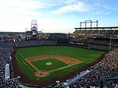
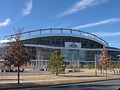

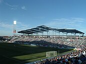
Colorado has five major professional sports leagues, all based in the Denver metropolitan area. Colorado is the least populous state with a franchise in each of the major professional sports leagues.
The Colorado Springs Snow Sox professional baseball team is based in Colorado Springs. The team is a member of the Pecos League, an independent baseball league which is not affiliated with Major or Minor League Baseball.[183][184]
The Pikes Peak International Hill Climb is a major hill climbing motor race held on the Pikes Peak Highway.
The Cherry Hills Country Club has hosted several professional golf tournaments, including the U.S. Open, U.S. Senior Open, U.S. Women’s Open, PGA Championship and BMW Championship.
Professional sports teams[edit]
| Team | Home | First game | Sport | League |
|---|---|---|---|---|
| Colorado Avalanche | Denver | October 6, 1995 | Ice hockey | National Hockey League |
| Colorado Eagles | Loveland | October 17, 2003 | Ice hockey | American Hockey League |
| Colorado Mammoth | Denver | January 3, 2003 | Lacrosse | National Lacrosse League |
| Colorado Rapids | Commerce City | April 13, 1996 | Soccer | Major League Soccer |
| Colorado Rapids 2 | Denver | March 27, 2022 | Soccer | MLS Next Pro |
| Colorado Rockies | Denver | April 5, 1993 | Baseball | Major League Baseball |
| Colorado Springs Switchbacks FC | Colorado Springs | March 28, 2015 | Soccer | USL Championship |
| Denver Barbarians | Denver | Spring 1967 | Rugby union | Pacific Rugby Premiership |
| Denver Broncos | Denver | September 9, 1960 | American football | National Football League |
| Denver Nuggets | Denver | September 27, 1967 | Basketball | National Basketball Association |
| Glendale Raptors | Glendale | Fall 2006 | Rugby union | Major League Rugby |
| Grand Junction Rockies | Grand Junction | June 18, 2012 | Baseball | Pioneer League |
| Northern Colorado Hailstorm FC | Windsor | April 6, 2022 | Soccer | USL League One |
| Northern Colorado Owlz | Windsor | May 25, 2022 | Baseball | Pioneer League |
| Rocky Mountain Vibes | Colorado Springs | June 2019 | Baseball | Pioneer League |
College athletics[edit]

The following universities and colleges participate in the National Collegiate Athletic Association Division I. The most popular college sports program is the University of Colorado Buffaloes, who used to play in the Big-12 but now play in the Pac-12. They have won the 1957 and 1991 Orange Bowl, 1995 Fiesta Bowl, and 1996 Cotton Bowl Classic.
| Team | School | City | Conference |
|---|---|---|---|
| Air Force Falcons | United States Air Force Academy | Colorado Springs | Mountain West[i] |
| Colorado Buffaloes | University of Colorado Boulder | Boulder | Pac-12[j] |
| Colorado State Rams | Colorado State University | Fort Collins | Mountain West |
| Denver Pioneers | University of Denver | Denver | NCHC / Summit[k] |
| Northern Colorado Bears | University of Northern Colorado | Greeley | Big Sky[l] |
| Colorado College Tigers | Colorado College | Colorado Springs | NCHC / Mountain West[m] |
Transportation[edit]

A Colorado state welcome sign
Colorado’s primary mode of transportation (in terms of passengers) is its highway system. Interstate 25 (I-25) is the primary north-south highway in the state, connecting Pueblo, Colorado Springs, Denver, and Fort Collins, and extending north to Wyoming and south to New Mexico. I-70 is the primary east-west corridor. It connects Grand Junction and the mountain communities with Denver and enters Utah and Kansas. The state is home to a network of US and Colorado highways that provide access to all principal areas of the state. Many smaller communities are connected to this network only via county roads.

The main terminal of Denver International Airport evokes the peaks of the Front Range.
Denver International Airport (DIA) is the third-busiest domestic U.S. and international airport in the world by passenger traffic.[185] DIA handles by far the largest volume of commercial air traffic in Colorado and is the busiest U.S. hub airport between Chicago and the Pacific coast, making Denver the most important airport for connecting passenger traffic in the western United States.
Public transportation bus services are offered both intra-city and inter-city—including the Denver metro area’s RTD services. The Regional Transportation District (RTD) operates the popular RTD Bus & Rail transit system in the Denver Metropolitan Area. As of January 2013 the RTD rail system had 170 light-rail vehicles, serving 47 miles (76 km) of track. In addition to local public transit, intercity bus service is provided by Burlington Trailways, Bustang, Express Arrow, and Greyhound Lines.

Amtrak operates two passenger rail lines in Colorado, the California Zephyr and Southwest Chief. Colorado’s contribution to world railroad history was forged principally by the Denver and Rio Grande Western Railroad which began in 1870 and wrote the book on mountain railroading. In 1988 the «Rio Grande» was acquired, but was merged into, the Southern Pacific Railroad by their joint owner Philip Anschutz. On September 11, 1996, Anschutz sold the combined company to the Union Pacific Railroad, creating the largest railroad network in the United States. The Anschutz sale was partly in response to the earlier merger of Burlington Northern and Santa Fe which formed the large Burlington Northern and Santa Fe Railway (BNSF), Union Pacific’s principal competitor in western U.S. railroading. Both Union Pacific and BNSF have extensive freight operations in Colorado.
Colorado’s freight railroad network consists of 2,688 miles of Class I trackage. It is integral to the U.S. economy, being a critical artery for the movement of energy, agriculture, mining, and industrial commodities as well as general freight and manufactured products between the East and Midwest and the Pacific coast states.[186]
In August 2014, Colorado began to issue driver licenses to aliens not lawfully in the United States who lived in Colorado.[187] In September 2014, KCNC reported that 524 non-citizens were issued Colorado driver licenses that are normally issued to U.S. citizens living in Colorado.[188]
Education[edit]


The first institution of higher education in the Colorado Territory was the Colorado Seminary, opened on November 16, 1864, by the Methodist Episcopal Church. The seminary closed in 1867 but reopened in 1880 as the University of Denver. In 1870, the Bishop George Maxwell Randall of the Episcopal Missionary District of Colorado and Parts Adjacent opened the first of what become the Colorado University Schools which would include the Territorial School of Mines opened in 1873 and sold to the Colorado Territory in 1874. These schools were initially run by the Episcopal Church.[189] An 1861 territorial act called for the creation of a public university in Boulder, though it would not be until 1876 that the University of Colorado was founded.[190] The 1876 act also renamed Territorial School of Mines as the Colorado School of Mines.[191] An 1870 territorial act created the Agricultural College of Colorado which opened in 1879.[192] The college was renamed the Colorado State College of Agriculture and Mechanic Arts in 1935, and became Colorado State University in 1957.
The first Catholic college in Colorado was the Jesuit Sacred Heart College, which was founded in New Mexico in 1877, moved to Morrison in 1884, and to Denver in 1887. The college was renamed Regis College in 1921 and Regis University in 1991.[193] On April 1, 1924, armed students patrolled the campus after a burning cross was found, the climax of tensions between Regis College and the locally-powerful Ku Klux Klan.[194]
Following a 1950 assessment by the Service Academy Board, it was determined that there was a need to supplement the U.S. Military and Naval Academies with a third school that would provide commissioned officers for the newly independent Air Force. On April 1, 1954, President Dwight Eisenhower signed a law that moved for the creation of a U.S. Air Force Academy.[195] Later that year, Colorado Springs was selected to host the new institution. From its establishment in 1955, until the construction of appropriate facilities in Colorado Springs was completed and opened in 1958, the Air Force Academy operated out of Lowry Air Force Base in Denver. With the opening of the Colorado Springs facility, the cadets moved to the new campus, though not in the full-kit march that some urban and campus legends suggest.[196] The first class of Space Force officers from the Air Force Academy commissioned on April 18, 2020.[197]
- Adams State University
- Aims Community College
- Arapahoe Community College
- Belleview Christian College & Bible Seminary
- Colorado Christian University
- Colorado College
- Colorado Mesa University
- Colorado Mountain College
- Colorado Northwestern Community College
- Colorado School of Mines
- Colorado State University System
- Colorado State University
- Colorado State University Pueblo
- CSU–Global Campus
- Colorado Technical University
- Community College of Aurora
- Community College of Denver
- Denver Seminary
- DeVry University
- Emily Griffith Opportunity School
- Fort Lewis College
- Front Range Community College
- Iliff School of Theology
- Johnson & Wales University
- Lamar Community College
- Metropolitan State University of Denver
- Morgan Community College
- Naropa University
- Nazarene Bible College
- Northeastern Junior College
- Otero College
- Pikes Peak State College
- Pueblo Community College
- Red Rocks Community College
- Regis University
- Rocky Mountain College of Art and Design
- Rocky Vista University College of Osteopathic Medicine
- Trinidad State College
- United States Air Force Academy
- University of Colorado System
- University of Colorado Boulder
- University of Colorado Colorado Springs
- University of Colorado Denver
- Anschutz Medical Campus
- Auraria Campus
- University of Denver
- University of Northern Colorado
- Western Colorado University
Military installations[edit]


The major military installations in Colorado include:
- Buckley Space Force Base (1938–)
- Air Reserve Personnel Center (1953–)
- Fort Carson (U.S. Army 1942–)
- Piñon Canyon Maneuver Site (1983–)
- Peterson Space Force Base (1942–)
- Cheyenne Mountain Space Force Station (1961–)
- Pueblo Chemical Depot (U.S. Army 1942–)
- Schriever Space Force Base (1983–)
- United States Air Force Academy (1954–)
Former military posts in Colorado include:
- Spanish Fort (Spanish Army 1819–1821)
- Fort Massachusetts (U.S. Army 1852–1858)
- Fort Garland (U.S. Army 1858–1883)
- Camp Collins (U.S. Army 1862–1870)
- Fort Logan (U.S. Army 1887–1946)
- Colorado National Guard Armory (1913-1933)
- Fitzsimons Army Hospital (U.S. Army 1918–1999)
- Denver Medical Depot (U.S. Army 1925-1949)[198]
- Lowry Air Force Base (1938–1994)
- Pueblo Army Air Base (1941-1948)
- Rocky Mountain Arsenal (U.S. Army 1942-1992)
- Camp Hale (U.S. Army 1942–1945)
- La Junta Army Air Field (1942-1946)
- Leadville Army Air Field (1943-1944)
Government[edit]
State government[edit]
| State Executive Officers | ||
|---|---|---|
| Office | Name | Party |
| Governor | Jared Polis | Democratic |
| Lieutenant Governor | Dianne Primavera | Democratic |
| Secretary of State | Jena Griswold | Democratic |
| Attorney General | Phil Weiser | Democratic |
| Treasurer | Dave Young | Democratic |
Like the federal government and all other U.S. states, Colorado’s state constitution provides for three branches of government: the legislative, the executive, and the judicial branches.
The Governor of Colorado heads the state’s executive branch. The current governor is Jared Polis, a Democrat. Colorado’s other statewide elected executive officers are the Lieutenant Governor of Colorado (elected on a ticket with the Governor), Secretary of State of Colorado, Colorado State Treasurer, and Attorney General of Colorado, all of whom serve four-year terms.
The seven-member Colorado Supreme Court is the state’s highest court, with seven justices. The Colorado Court of Appeals, with 22 judges, sits in divisions of three judges each. Colorado is divided into 22 judicial districts, each of which has a district court and a county court with limited jurisdiction. The state also has specialized water courts, which sit in seven distinct divisions around the state and which decide matters relating to water rights and the use and administration of water.
The state legislative body is the Colorado General Assembly, which is made up of two houses – the House of Representatives and the Senate. The House has 65 members and the Senate has 35. As of 2021, the Democratic Party holds a 20 to 15 majority in the Senate and a 41 to 24 majority in the House.
Most Coloradans are native to other states (nearly 60% according to the 2000 census),[199] and this is illustrated by the fact that the state did not have a native-born governor from 1975 (when John David Vanderhoof left office) until 2007, when Bill Ritter took office; his election the previous year marked the first electoral victory for a native-born Coloradan in a gubernatorial race since 1958 (Vanderhoof had ascended from the Lieutenant Governorship when John Arthur Love was given a position in Richard Nixon’s administration in 1973).
Tax is collected by the Colorado Department of Revenue.
Politics[edit]
| Colorado registered voters as of March 1, 2023[200] | |||
|---|---|---|---|
| Party | Number of Voters | Percentage | |
| Unaffiliated | 1,761,728 | 46.15% | |
| Democratic | 1,055,164 | 27.64% | |
| Republican | 932,127 | 24.42% | |
| Libertarian | 39,689 | 1.04% | |
| American Constitution | 11,595 | 0.30% | |
| Green | 8,400 | 0.22% | |
| Approval Voting | 4,452 | 0.12% | |
| Unity | 3,193 | 0.08% | |
| Total | 3,817,369 | 100.00% |
| Year | Republican | Democratic | Third party | |||
|---|---|---|---|---|---|---|
| No. | % | No. | % | No. | % | |
| 2020 | 1,364,607 | 41.90% | 1,804,352 | 55.40% | 88,021 | 2.70% |
| 2016 | 1,202,484 | 43.25% | 1,338,870 | 48.16% | 238,893 | 8.59% |
| 2012 | 1,185,243 | 46.09% | 1,323,102 | 51.45% | 63,501 | 2.47% |
| 2008 | 1,073,629 | 44.71% | 1,288,633 | 53.66% | 39,200 | 1.63% |
| 2004 | 1,101,256 | 51.69% | 1,001,725 | 47.02% | 27,344 | 1.28% |
| 2000 | 883,745 | 50.75% | 738,227 | 42.39% | 119,393 | 6.86% |
| 1996 | 691,848 | 45.80% | 671,152 | 44.43% | 147,704 | 9.78% |
| 1992 | 562,850 | 35.87% | 629,681 | 40.13% | 376,649 | 24.00% |
| 1988 | 728,177 | 53.06% | 621,453 | 45.28% | 22,764 | 1.66% |
| 1984 | 821,818 | 63.44% | 454,974 | 35.12% | 18,589 | 1.44% |
| 1980 | 652,264 | 55.07% | 367,973 | 31.07% | 164,178 | 13.86% |
| 1976 | 584,367 | 54.05% | 460,353 | 42.58% | 36,415 | 3.37% |
| 1972 | 597,189 | 62.61% | 329,980 | 34.59% | 26,715 | 2.80% |
| 1968 | 409,345 | 50.46% | 335,174 | 41.32% | 66,680 | 8.22% |
| 1964 | 296,767 | 38.19% | 476,024 | 61.27% | 4,195 | 0.54% |
| 1960 | 402,242 | 54.63% | 330,629 | 44.91% | 3,375 | 0.46% |
| 1956 | 394,479 | 59.49% | 263,997 | 39.81% | 4,598 | 0.69% |
| 1952 | 379,782 | 60.27% | 245,504 | 38.96% | 4,817 | 0.76% |
| 1948 | 239,714 | 46.52% | 267,288 | 51.88% | 8,235 | 1.60% |
| 1944 | 268,731 | 53.21% | 234,331 | 46.40% | 1,977 | 0.39% |
| 1940 | 279,576 | 50.92% | 265,554 | 48.37% | 3,874 | 0.71% |
| 1936 | 181,267 | 37.09% | 295,021 | 60.37% | 12,396 | 2.54% |
| 1932 | 189,617 | 41.43% | 250,877 | 54.81% | 17,202 | 3.76% |
| 1928 | 253,872 | 64.72% | 133,131 | 33.94% | 5,239 | 1.34% |
| 1924 | 195,171 | 57.02% | 75,238 | 21.98% | 71,851 | 20.99% |
| 1920 | 173,248 | 59.32% | 104,936 | 35.93% | 13,869 | 4.75% |
| 1916 | 102,308 | 34.75% | 178,816 | 60.74% | 13,251 | 4.50% |
| 1912 | 58,386 | 21.88% | 114,232 | 42.80% | 94,262 | 35.32% |
| 1908 | 123,693 | 46.88% | 126,644 | 48.00% | 13,521 | 5.12% |
| 1904 | 134,661 | 55.26% | 100,105 | 41.08% | 8,901 | 3.65% |
| 1900 | 93,072 | 42.04% | 122,733 | 55.43% | 5,603 | 2.53% |
| 1896 | 26,271 | 13.86% | 161,005 | 84.95% | 2,263 | 1.19% |
| 1892 | 38,620 | 41.13% | 0 | 0.00% | 55,271 | 58.87% |
| 1888 | 50,772 | 55.22% | 37,549 | 40.84% | 3,625 | 3.94% |
| 1884 | 36,084 | 54.25% | 27,723 | 41.68% | 2,712 | 4.08% |
| 1880 | 27,450 | 51.26% | 24,647 | 46.03% | 1,449 | 2.71% |
Colorado was once considered a swing state, but has become a relatively safe blue state in both state and federal elections. In presidential elections, it had not been won until 2020 by double digits since 1984 and has backed the winning candidate in 9 of the last 11 elections. Coloradans have elected 17 Democrats and 12 Republicans to the governorship in the last 100 years.
In presidential politics, Colorado was considered a reliably Republican state during the post-World War II era, voting for the Democratic candidate only in 1948, 1964, and 1992. However, it became a competitive swing state in the 1990s. Since the mid-2000s, it has swung heavily to the Democrats, voting for Barack Obama in 2008 and 2012, Hillary Clinton in 2016, and Joe Biden in 2020.
Colorado politics has the contrast between conservative cities such as Colorado Springs and Grand Junction and liberal cities such as Boulder and Denver. Democrats are strongest in metropolitan Denver, the college towns of Fort Collins and Boulder, southern Colorado (including Pueblo), and several western ski resort counties. The Republicans are strongest in the Eastern Plains, Colorado Springs, Greeley, and far Western Colorado near Grand Junction.
Colorado is represented by two United States Senators:
- United States Senate Class 2, John Hickenlooper (Democratic) 2021–
- United States Senate Class 3, Michael Bennet (Democratic) 2009–
Colorado is represented by seven Representatives to the United States House of Representatives:
- Colorado’s 1st congressional district, Diana DeGette (Democratic) 1997–
- Colorado’s 2nd congressional district, Joe Neguse (Democratic) 2019–
- Colorado’s 3rd congressional district, Lauren Boebert (Republican) 2021–
- Colorado’s 4th congressional district, Ken Buck (Republican) 2015–
- Colorado’s 5th congressional district, Doug Lamborn (Republican) 2007–
- Colorado’s 6th congressional district, Jason Crow (Democratic) 2019–
- Colorado’s 7th congressional district, Brittany Pettersen (Democratic) 2023–
- Colorado’s 8th congressional district, Yadira Caraveo (Democratic) 2023–
In a 2020 study, Colorado was ranked as the 7th easiest state for citizens to vote in.[202]
Significant initiatives and legislation enacted in Colorado[edit]
In 1881 Colorado voters approved a referendum that selected Denver as the state capital.
Colorado was the first state in the union to enact, by voter referendum, a law extending suffrage to women. That initiative was approved by the state’s voters on November 7, 1893.[203]
On the November 8, 1932, ballot, Colorado approved the repeal of alcohol prohibition more than a year before the Twenty-first Amendment to the United States Constitution was ratified.
Colorado has banned, via C.R.S. section 12-6-302, the sale of motor vehicles on Sunday since at least 1953.[204]
In 1972 Colorado voters rejected a referendum proposal to fund the 1976 Winter Olympics, which had been scheduled to be held in the state. Denver had been chosen by the International Olympic Committee as the host city on May 12, 1970.[205]
In 1992, by a margin of 53 to 47 percent, Colorado voters approved an amendment to the state constitution (Amendment 2) that would have prevented any city, town, or county in the state from taking any legislative, executive or judicial action to recognize homosexuals or bisexuals as a protected class.[206] In 1996, in a 6–3 ruling in Romer v. Evans, the U.S. Supreme Court found that preventing protected status based upon homosexuality or bisexuality did not satisfy the Equal Protection Clause.[207]
In 2006, voters passed Amendment 43, which banned gay marriage in Colorado.[208] That initiative was nullified by the U.S. Supreme Court’s 2015 decision in Obergefell v. Hodges.
In 2012, voters amended the state constitution protecting the «personal use» of marijuana for adults, establishing a framework to regulate cannabis like alcohol. The first recreational marijuana shops in Colorado, and by extension the United States, opened their doors on January 1, 2014.[182]
On May 29, 2019, Governor Jared Polis signed House Bill 1124 immediately prohibiting law enforcement officials in Colorado from holding undocumented immigrants solely based on a request from U.S. Immigration and Customs Enforcement.[209]
Native American reservations[edit]

The two Native American reservations remaining in Colorado are:
- Southern Ute Indian Reservation — Southern Ute Indian Tribe (1873; Ute dialect: Kapuuta-wa Moghwachi Núuchi-u)
- Ute Mountain Ute Indian Reservation — Ute Mountain Ute Tribe (1940; Ute dialect: Wʉgama Núuchi)
The two abolished Indian reservations in Colorado were:
- Cheyenne and Arapaho Indian Reservation (1851–1870)
- Ute Indian Reservation (1855–1873)
Protected areas[edit]


Colorado is home to 4 national parks, 9 national monuments, 3 national historic sites, 2 national recreation areas, 4 national historic trails, 1 national scenic trail, 11 national forests, 2 national grasslands, 44 national wildernesses, 3 national conservation areas, 8 national wildlife refuges, 3 national heritage areas, 26 national historic landmarks, 16 national natural landmarks, more than 1,500 National Register of Historic Places, 1 wild and scenic river, 42 state parks, 307 state wildlife areas, 93 state natural areas, 28 national recreation trails, 6 regional trails, and numerous other scenic, historic, and recreational areas.
The following are the 23 units of the National Park System in Colorado:
- Amache National Historic Site (2022)
- Arapaho National Recreation Area[n] (1978)
- Bent’s Old Fort National Historic Site (1960)
- Black Canyon of the Gunnison National Park (NM 1933, NP 1999)
- Browns Canyon National Monument[o] (2015)
- California National Historic Trail[p] (1992)
- Camp Hale-Continental Divide National Monument[n] (2022)
- Canyons of the Ancients National Monument[q] (2000)
- Chimney Rock National Monument[n] (2012)
- Colorado National Monument (1911)
- Continental Divide National Scenic Trail[r][s] (1978)
- Curecanti National Recreation Area (1965)
- Dinosaur National Monument[t] (1915)
- Florissant Fossil Beds National Monument (1969)
- Great Sand Dunes National Park and Preserve (NM 1932, NP 2004)
- Hovenweep National Monument[u] (1923)
- Mesa Verde National Park (1906) and UNESCO World Heritage Site (1978)
- Old Spanish National Historic Trail[v] (2002)
- Pony Express National Historic Trail[w] (1992)
- Rocky Mountain National Park (1915)
- Sand Creek Massacre National Historic Site (2007)
- Santa Fe National Historic Trail[x] (1987)
- Yucca House National Monument[y] (1919)
See also[edit]
- Outline of Colorado
- Index of Colorado-related articles
- Bibliography of Colorado
Footnotes[edit]
- ^ a b Elevation adjusted to North American Vertical Datum of 1988.
- ^ Early explorers identified the Gunnison River in Colorado as the headwaters of the Colorado River. The Grand River in Colorado was later tentatively identified as the primary headwaters of the river. In 1916, E.C. LaRue, the Chief Hydrologist of the United States Geological Survey, identified the Green River in southwestern Wyoming as the primary headwaters of the Colorado River.
- ^ The official Four Corners Monument is located at 36°59′56.31591″N, 109°2′42.62064″W, a short distance east of the 37°N, 109°02′48″W location Congress originally designated.
- ^ a b c United States Census Bureau estimates of county population as of July 1, 2021,[93]
- ^ As a consolidated city and county, the City and County of Denver is its own county seat.[94]
- ^ As a consolidated city and county, the City and County of Broomfield is its own county seat.[94]
- ^ a b c United States Census Bureau estimates of municipal population as of July 1, 2021[96]
- ^ Persons of Hispanic or Latino origin are not distinguished between total and partial ancestry.
- ^ Several Air Force teams participate in other conferences, or as independents, in sports that the MW does not sponsor:
- Boxing, a men-only sport that is not sanctioned by the NCAA, competes as an independent.
- Fencing, a coeducational sport with men’s and women’s squads, also competes as an independent.
- Men’s and women’s gymnastics both compete in the Mountain Pacific Sports Federation.
- Men’s ice hockey competes in Atlantic Hockey.
- Men’s lacrosse competes in the ASUN Conference.
- Rifle, which at Air Force is a coeducational sport, competes in the Patriot Rifle Conference.
- Men’s soccer and women’s swimming & diving compete in the Western Athletic Conference.
- Men’s wrestling competes in the Big 12 Conference.
- ^ Several Colorado teams participate in other conferences in sports that the Pac-12 does not sponsor:
- Men’s and women’s indoor track & field compete in the Mountain Pacific Sports Federation.
- Skiing, a coeducational sport with men’s and women’s squads, competes in the Rocky Mountain Intercollegiate Ski Association.
- ^ Several Denver teams participate in other conferences in sports that The Summit League does not sponsor:
- Women’s gymnastics competes in the Big 12 Conference.
- Men’s ice hockey competes in the National Collegiate Hockey Conference.
- Men’s and women’s lacrosse compete in the Big East Conference.
- Skiing, a coeducational sport with men’s and women’s squads, competes in the Rocky Mountain Intercollegiate Ski Association.
- ^ Several Northern Colorado teams participate in other conferences in sports that the Big Sky does not sponsor:
- Baseball competes in the Summit League.
- Women’s swimming & diving competes in the Western Athletic Conference.
- Men’s wrestling competes in the Big 12 Conference.
- ^ Colorado College, otherwise an NCAA Division III member, has two Division I teams. Men’s ice hockey competes in the National Collegiate Hockey Conference and women’s soccer competes in the Mountain West.
- ^ a b c Arapaho National Recreation Area, Camp Hale-Continental Divide National Monument, and Chimney Rock National Monument are managed by the United States Forest Service, United States Department of Agriculture.
- ^ Browns Canyon National Monument is jointly managed by the Bureau of Land Management, United States Department of the Interior, and the United States Forest Service, United States Department of Agriculture.
- ^ The California National Historic Trail traverses ten U.S. states: Missouri, Kansas, Nebraska, Colorado, Wyoming, Idaho, Utah, Nevada, Oregon, and California.
- ^ Canyons of the Ancients National Monument is managed by the Bureau of Land Management, United States Department of the Interior.
- ^ The Continental Divide National Scenic Trail traverses five U.S. states: Montana, Idaho, Wyoming, Colorado, and New Mexico.
- ^ The Continental Divide National Scenic Trail is jointly managed by the United States Forest Service, United States Department of Agriculture, and the National Park Service and Bureau of Land Management, United States Department of the Interior.
- ^ Dinosaur National Monument extends into the State of Utah.
- ^ Hovenweep National Monument extends into the State of Utah.
- ^ The Old Spanish National Historic Trail traverses six U.S. states: New Mexico, Colorado, Utah, Arizona, Nevada, and California.
- ^ The Pony Express National Historic Trail traverses eight U.S. states: Missouri, Kansas, Nebraska, Colorado, Wyoming, Utah, Nevada, and California.
- ^ The Santa Fe National Historic Trail traverses five U.S. states: Missouri, Kansas, Colorado, Oklahoma, and New Mexico.
- ^ Yucca House National Monument remains undeveloped.
References[edit]
- ^ «Lawmakers name ‘Rocky Mountain High’ second state song | 9news.com». Archive.9news.com. March 13, 2006. Archived from the original on November 30, 2015. Retrieved April 1, 2016.
- ^ a b c President of the United States of America (August 1, 1876). «Proclamation of the Admission of Colorado to the Union» (php). The American Presidency Project. Retrieved November 15, 2018.
- ^ a b «Mount Elbert». NGS Data Sheet. National Geodetic Survey, National Oceanic and Atmospheric Administration, United States Department of Commerce. Retrieved October 20, 2011.
- ^ a b c «Elevations and Distances in the United States». United States Geological Survey. 2001. Archived from the original on October 15, 2011. Retrieved October 21, 2011.
- ^ «US Census Bureau QuickFacts». Retrieved April 30, 2022.
- ^ «Colorado—Definition». Merriam-webster.com. August 13, 2010. Retrieved June 5, 2011.
- ^ «Colorado—dictionary.reference.com». Dictionary.com, LLC. Retrieved August 17, 2013.
- ^ Clark, Kyle (June 27, 2018). What’s the right way to pronounce ‘Colorado?’ (TV news magazine segment). Contributor: Rich Sandoval, linguist at Metropolitan State University of Denver. KUSA-TV. Archived from the original on November 23, 2021. Retrieved August 4, 2018.
[Sandoval] found five pronunciations.
- ^ a b c d e f g h «QuickFacts for Colorado». United States Census Bureau. Retrieved October 1, 2022.
- ^ «State Name and Nickname». Colorado Encyclopedia. August 31, 2017. Retrieved April 21, 2021.
- ^ a b c «An Act to provide a temporary Government for the Territory of Colorado» (PDF). Thirty-sixth United States Congress. February 28, 1861. Archived (PDF) from the original on October 9, 2022. Retrieved November 15, 2018.
- ^ «Creative Services». Archived from the original on February 19, 2015. Retrieved February 5, 2016.
- ^ Quillen, Ed (March 18, 2007). «Coloradoan or Coloradan». The Denver Post. Denver. Retrieved July 30, 2010.
- ^ «What Climate Change means for Colorado» (PDF). EPA 430-F-16-008. Environmental Protection Agency. August 2016. Archived (PDF) from the original on October 9, 2022.
- ^ «Fossilized Footprints». United States National Park Service. Retrieved August 6, 2022.
- ^ Ashley Strickland (August 4, 2022). «Discovery in paleontologist’s backyard reveals evidence of North America’s early humans». Cable News Network. Retrieved August 6, 2022.
- ^ «Genocide Wiped Out Native American Population Archived September 22, 2010, at the Wayback Machine», Discovery News, September 20, 2010.
- ^ Multiple Property Documentation Form. «National-Register-of-Historic» (PDF). www.nps.gov. Archived (PDF) from the original on October 9, 2022.
- ^ Report of the exploring expedition from Santa Fé, New Mexico, to the junction of the Grand and Green Rivers of the great Colorado of the West, in 1859: under the command of Capt. J. N. Macomb, Corps of topographical engineers, Volume 1 @ archive.org
- ^ Frazier, Donald Shaw (1995). Blood & treasure : Confederate Empire in the Southwest (1st ed.). College Station: Texas A & M University Press. ISBN 0585303304. OCLC 45732362.
- ^ Forty-third United States Congress (March 3, 1875). «An Act to Enable the People of Colorado to Form a Constitution and State Government, and for the Admission of the Said State into the Union on an Equal Footing with the Original States» (PDF). Archived (PDF) from the original on October 9, 2022. Retrieved November 15, 2018.
- ^ Shu Liu and Linda M. Meyer, Carnations and the Floriculture Industry: Documenting the Cultivation and Marketing of Flowers in Colorado, 2007
- ^ Kingman, Dick (1986). A History—Colorado Flower Growers and its People (PDF). Colorado Greenhouse Growers Association, Inc. Archived from the original (PDF) on March 4, 2016. Retrieved March 13, 2016.
- ^ Rebchook, John (October 15, 2015). «Neighbors want historic designation for NW Denver home».
- ^ Philip Taft and Philip Ross, «American Labor Violence: Its Causes, Character, and Outcome», The History of Violence in America: A Report to the National Commission on the Causes and Prevention of Violence, ed. Hugh Davis Graham and Ted Robert Gurr, 1969.
- ^ McGovern, George; Guttridge, Leonard. The Great Coalfield War. Boston: Houghton Mifflin Company, 1972. 88, 89 p.
- ^ Devine, Edward T.; Ryan, John A.; Lapp, John A. (1921). The Denver Tramway Strike of 1920. The Denver Commission of Religious Forces and National Catholic Welfare Council. p. 33. Retrieved October 12, 2020.
- ^ Schreck, Christopher. «The Strike of 1927». Colorado Fuel and Iron: Culture and Industry in Southern Colorado. Retrieved November 6, 2019.
- ^ Gerald Emerson Sherard (2006). Pre-1963 Colorado mining fatalities (Report). p. 1. Retrieved November 12, 2019.
- ^ a b Louvaris, Elenie (August 20, 2019). «Ku Klux Klan in Colorado». Colorado Encyclopedia. Retrieved April 12, 2021.
- ^ Canterbury, Carie (April 15, 2019). «Ku Klux Klan once a Fremont County political powerhouse». Cañon City Daily Record. Cañon City, CO. Archived from the original on December 15, 2020. Retrieved April 12, 2021.
- ^ Iversen, Kristen (June 12, 2012). «Under The ‘Nuclear Shadow’ Of Colorado’s Rocky Flats». NPR.
- ^ «The Chicano Movement’s Denver Roots Run Deep». Talk of the Nation. National Public Radio. June 30, 2011. Retrieved March 25, 2021.
- ^ Simpson, Kelly (March 23, 2012). «Defining ‘Chicanismo’ Since the 1969 Denver Youth Conference». KCET. Retrieved October 15, 2022.
- ^ «It’s Been 50 Years Since Colorado Passed This Groundbreaking Abortion Law». Time. April 25, 2017. Retrieved February 9, 2021.
- ^ Follman, Mark; Andrews, Becca. «Here’s the terrifying new data on how Columbine spawned dozens of copycats». Mother Jones. Retrieved February 9, 2021.
- ^ «How Colorado’s gun laws have changed since the Aurora shooting». The Guardian. July 25, 2015. Retrieved February 9, 2021.
- ^ Hern, Elizabeth; Ehern, Ez | (March 22, 2021). «Boulder shooting: Gunman kills 10, including police officer, at King Soopers». The Denver Post. Retrieved March 23, 2021.
- ^ Coffield, Alfred (May 29, 2020). «USS Colorado Continues the Tradition of the Submarine Battle Flag». Defense Visual Information Distribution Service. Groton, CT. Retrieved May 10, 2021.
- ^ «Colorado is NOT a perfect rectangle». Fascinating Maps. Archived from the original on June 17, 2019. Retrieved November 15, 2018.
- ^ a b «Colorado is a rectangle? Think again». The Big Think, Inc. October 31, 2018. Retrieved November 15, 2018.
- ^ «Shared Solution: Four Corners». NGS Survey Monument Data Sheet. United States National Geodetic Survey. May 7, 2003.
- ^ «Colorado County Highpoints». Retrieved February 27, 2012.
- ^ a b Doesken, Nolan J.; Pielke, Roger A. Sr.; Bliss, Odilia A.P. (January 2003). «Climate of Colorado». Colorado Climate Center—Department of Atmospheric Science—Colorado State University. Archived from the original on February 9, 2009. Retrieved January 25, 2009.
- ^ Simpson, Kevin (April 8, 2019). «Colorado cattle rustling’s colorful history helps modern brand inspectors keep up with a changing crime». The Colorado Sun. Retrieved March 27, 2021.
- ^ U.S. Forest Service. «Rocky Mountain Region 14ers». Retrieved November 6, 2009.
- ^ U.S. Geological Survey. «Elevations and Distances». Archived from the original on January 16, 2008. Retrieved September 8, 2006.
- ^ «Pikes Peak, Colorado». Peakbagger.com. Retrieved October 10, 2009.
- ^ Hansen, Wallace R.; Chronic, John; Matelock, John (1979) [first published 1978]. Climatography of the Front Range Urban Corridor and vicinity, Colorado (PDF). Geological Survey Professional Paper 1019 (Report). Washington, DC: USG Printing Office. Archived (PDF) from the original on October 9, 2022. Retrieved March 21, 2016.
- ^ «Climate of Colorado». Wrcc.dri.edu. Archived from the original on April 7, 2016. Retrieved April 1, 2016.
- ^ a b «Denver, Colorado Travel Weather Averages». Weatherbase. Retrieved July 10, 2013.
- ^ «Relocating to Greenhorn Valley». Archived from the original on May 25, 2017. Retrieved February 9, 2017.
- ^ a b Childs, Samuel J.; R. S. Schumacher (2019). «An Updated Severe Hail and Tornado Climatology for Eastern Colorado». J. Appl. Meteorol. Climatol. 58 (10): 2273–2293. Bibcode:2019JApMC..58.2273C. doi:10.1175/JAMC-D-19-0098.1.
- ^ «Historic Denver Hailstorm Was Called Worst in American History». July 11, 2014.
- ^ «Hailstorm that hammered west metro Denver May 8 is costliest ever for Colorado». May 23, 2017.
- ^ Slater, Jane (May 28, 2008). «Thursday’s Tornado State’s 4th Costliest Disaster». KMGH. Archived from the original on June 4, 2008. Retrieved January 25, 2009.
- ^ Prendergast, Alan (April 29, 2015). «The 1965 Flood: How Denver’s Greatest Disaster Changed the City».
- ^ «Denver’s Consecutive 90 Degree Streaks». National Weather Service. Retrieved October 10, 2009.
- ^ «A History of Drought» (PDF). Archived (PDF) from the original on October 9, 2022. Retrieved July 30, 2010.
- ^ «People living in this part of Colorado are most at risk of climate change’s adverse health effects, study says». The Denver Post. April 23, 2019.
- ^ Zielinski, Sarah. «The Colorado River Runs Dry». Smithsonian Magazine. Retrieved April 22, 2020.
- ^ «On the Water-Starved Colorado River, Drought Is the New Normal». Yale E360. Retrieved April 22, 2020.
- ^ Hood, Grace. «As Climate Warms, Colorado’s Record-Setting Hot Days Outnumber Cold Ones 3:1». Colorado Public Radio. Retrieved April 22, 2020.
- ^ «Over a quarter of Colorado is now officially in a drought». The Denver Post. October 5, 2019. Retrieved April 22, 2020.
- ^ «What Climate Change Means for Colorado» (PDF). United States Environmental Protection Agency. August 2016.
- ^ «Record Highest Temperatures by State» (PDF). National Climatic Data Center. January 1, 2004. Archived from the original (PDF) on November 17, 2001. Retrieved January 11, 2007.
- ^ «Record Lowest Temperatures by State» (PDF). National Climatic Data Center. January 1, 2004. Archived from the original (PDF) on November 17, 2001. Retrieved January 11, 2007.
- ^ «NOAA’s National Weather Service—National Climate». W2.weather.gov. Retrieved April 1, 2016.
- ^ Colorado Climate Center (extreme temperatures)«Colorado Climate Center». Retrieved February 6, 2023.
- ^ «Recent Earthquakes in the U.S.» U.S. Geological Survey. January 17, 2013. Archived from the original on January 17, 2013.
- ^ «Largest Colorado quake since 1973 shakes homes». USA Today. August 23, 2011. Retrieved August 23, 2011.
- ^ «Four earthquakes rumble Colorado overnight | OutThere Colorado». OutThere Colorado. August 24, 2018. Retrieved September 10, 2018.
- ^ liz.forster@gazette.com, LIZ FORSTER. «3 earthquakes reported overnight in Colorado». Colorado Springs Gazette. Retrieved September 10, 2018.
- ^ a b Purtell, Joe (November 18, 2020). «Wolves Are Coming Back to Colorado. Now Comes the Tricky Part». Sierra. Sierra Club. Retrieved March 25, 2021.
- ^ Bruce Finley (January 22, 2020). «Polis welcomes wolves back to Colorado after wildlife officers confirm pack of 6 in Moffat County». Denver Post.
- ^ «As Colorado starts planning to bring back wolves, Rio Blanco County’s leaders say they won’t allow it». The Denver Post. March 21, 2021.
- ^ Gillbert, David (January 12, 2022). «Colorado wildlife officials just legalized hazing wolves. It came too late for a cowboy whose dog was killed». The Colorado Sun. Retrieved February 3, 2022.
- ^ Mitton, Jeff (December 9, 2019). «Introduced mountain goats have colonized much of the land above the trees». Colorado Arts and Sciences Magazine. Boulder, CO: University of Colorado Boulder. Retrieved March 1, 2021.
- ^ «CPW launches study to identify unknown disease in mountain goats». Mount Evans, CO: Colorado Parks and Wildlife. August 11, 2021. Retrieved March 1, 2021.
- ^ McKee, Spencer (August 11, 2020). «Study launched to identify disease that’s killing mountain goats in Colorado». Out There Colorado. Retrieved March 1, 2021.
- ^ «Antelope Numbers Across 6 States». GoHunt. Archived from the original on March 12, 2016. Retrieved March 24, 2021.
- ^ Brown, Jennifer (January 21, 2019). «Colorado’s booming pronghorn population is running horns-first into newly built neighborhoods». The Colorado Sun. Retrieved March 24, 2021.
- ^ «Antilocapra americana«. IUCN Red List of Threatened Species. 2016. 2017 [errata version of 2016 assessment]. doi:10.2305/IUCN.UK.2016-3.RLTS.T1677A50181848.en. Retrieved March 25, 2021.
- ^ «Southwestern Red Squirrel». American Society of Mammalogists. Retrieved February 3, 2022.
- ^ Sommariva, Kelly (February 6, 2014). «9 fascinating facts about pika in Colorado». Denver: KUSA. Retrieved February 3, 2022.
- ^ «Yellow Bellied Marmot». Clear Creek County, CO: Clear Creek County Tourism Bureau. Retrieved February 3, 2022.
- ^ «Moose Reintroduction» (PDF). Colorado Parks and Wildlife. November 2013. Archived (PDF) from the original on October 9, 2022. Retrieved February 3, 2022.
- ^ Cahill, Caitlyn. «Rabbits». Arapahoe County Government. Retrieved February 3, 2022.
- ^ Brady, Jeff (December 7, 2003). «Coyote Hunt for Colorado». National Public Radio. Retrieved February 3, 2022.
- ^ «Black-tailed Prairie Dogs». Jefferson County Government. Retrieved February 3, 2022.
- ^ «Swift Fox Conservation Team». Colorado Parks and Wildlife. Retrieved February 3, 2022.
- ^ Zimmer, Amy (January 6, 2020). «Colorado’s Small Mammals, Part III: Mustelids». Colorado Virtual Library. Retrieved February 3, 2022.
- ^ «Annual Estimates of the Resident Population for Counties in Colorado: April 1, 2020 to July 1, 2021 (CO-EST2021-POP-08)». United States Census Bureau, United States Department of Commerce. March 2022. Retrieved September 30, 2022.
- ^ a b c «Active Colorado Municipalities». State of Colorado, Department of Local Affairs, Division of Local Government. Retrieved September 4, 2022.
- ^ «State of Colorado Incorporated Places — Current/TAB20 — Data as of January 1, 2020». United States Census Bureau. January 1, 2020. Retrieved September 4, 2022.
- ^ «Annual Estimates of the Resident Population for Incorporated Places in Colorado: April 1, 2020 to July 1, 2021 (SUB-IP-EST2021-POP-08)». United States Census Bureau, United States Department of Commerce. May 2022. Retrieved September 30, 2022.
- ^ «State of Colorado Census Designated Places — BAS20 — Data as of January 1, 2020». United States Census Bureau. Retrieved September 30, 2022.
- ^ Revised Delineations of Metropolitan Statistical Areas, Micropolitan Statistical Areas, and Combined Statistical Areas, and Guidance on Uses of the Delineations of These Areas (March 6, 2020). «0MB BULLETIN NO. 20-01» (PDF). Office of Management and Budget. Archived (PDF) from the original on October 9, 2022. Retrieved November 11, 2021.
{{cite web}}: CS1 maint: multiple names: authors list (link) - ^ «Race and Ethnicity in the United States: 2010 Census and 2020 Census». census.gov. United States Census Bureau. August 12, 2021. Retrieved September 26, 2021.
- ^ a b Gibson, Campbell; Jung, Kay (September 2002). «Historical Census Statistics on Population Totals By Race, 1790 to 1990, and By Hispanic Origin, 1970 to 1990, For The United States, Regions, Divisions, and States». Population Division. U.S. Census Bureau. Archived from the original on July 25, 2008. Retrieved April 17, 2012.
- ^ «Population of Colorado—Census 2010 and 2000 Interactive Map, Demographics, Statistics, Quick Facts». CensusViewer.com. Retrieved April 1, 2016.
- ^ 2010 Census Data. «2010 Census Data—2010 Census». Census.gov. Retrieved April 1, 2016.
- ^ «Profile of General Population and Housing Characteristics: 2010 : 2010 Demographic Profile Data». Factfinder2.census.gov. Archived from the original (PDF) on May 21, 2019. Retrieved April 1, 2016.
- ^ «Historical Census Statistics on Population Totals By Race, 1790 to 1990, and By Hispanic Origin, 1970 to 1990, For The United States, Regions, Divisions, and States». U.S. Census Bureau. Archived from the original on December 24, 2014. Retrieved January 3, 2012.
- ^ «Colorado QuickFacts from the US Census Bureau». Quickfacts.census.gov. Archived from the original on February 19, 2016. Retrieved April 1, 2016.
- ^ «talking about Colorado in «nada»«. Elcastellano.org. June 30, 2007. Retrieved July 30, 2010.
- ^ «National Vital Statistics Reports, Volume 57, Number 12, (March 18, 2009)» (PDF). Centers for Disease Control and Prevention. Archived (PDF) from the original on October 9, 2022. Retrieved July 30, 2010.
- ^ «Department of Public Health and Environment |». Cdphe.state.co.us. Retrieved April 1, 2016.
- ^ «People of Colorado statistics». StateMaster.com. June 15, 2007. Archived from the original on April 21, 2016. Retrieved April 1, 2016.
- ^ «Losing ground» (PDF). Adworks.org. Archived (PDF) from the original on October 9, 2022. Retrieved April 1, 2016.
- ^ Exner, Rich (June 3, 2012). «Americans under age 1 now mostly minorities, but not in Ohio: Statistical Snapshot». The Plain Dealer.
- ^ «Births: Final Data for 2013 Volume 64, Number 1» (PDF). National Vital Statistics Reports, Centers for Disease Control and Prevention. January 15, 2015. Archived (PDF) from the original on October 9, 2022. Retrieved August 8, 2017.
- ^ «Births: Final Data for 2014 Volume 64, Number 12» (PDF). National Vital Statistics Reports, Centers for Disease Control and Prevention. December 23, 2015. Archived (PDF) from the original on October 9, 2022. Retrieved August 8, 2017.
- ^ «Births: Final Data for 2015 Volume 66, Number 1» (PDF). National Vital Statistics Reports, Centers for Disease Control and Prevention. January 5, 2017. Archived (PDF) from the original on October 9, 2022. Retrieved August 8, 2017.
- ^ Nvsr67_01.pdf. «National Vital Statistics Reports» (PDF). www.cdc.gov. Centers for Disease Control and Prevention. Archived (PDF) from the original on October 9, 2022.
- ^ a b «Births: Final Data for 2017» (PDF). National Vital Statistics Reports, Centers for Disease Control and Prevention. Archived (PDF) from the original on November 11, 2018.
- ^
«Data» (PDF). www.cdc.gov. Centers for Disease Control and Prevention. Archived (PDF) from the original on October 9, 2022. Retrieved December 2, 2019. - ^
«Data» (PDF). www.cdc.gov. Centers for Disease Control and Prevention. Archived (PDF) from the original on October 9, 2022. Retrieved March 27, 2021. - ^
«Data» (PDF). www.cdc.gov. Archived (PDF) from the original on October 9, 2022. Retrieved February 20, 2022. - ^
«Data» (PDF). www.cdc.gov. Retrieved February 2, 2022. - ^ Seaman, Jessica (March 22, 2019). «Colorado teen pregnancies dropped 20 percent near these clinics. Now their funding is at risk». The Denver Post. Denver. Retrieved May 21, 2019.
By increasing access to long-term birth control such as intrauterine devices, Colorado has reduced teen pregnancies by about 20 percent in zip codes near clinics that receive federal funding … Statewide, the birth rate for … ages 15 and 19 dropped 59 [%] … in 2017
- ^ Brown, Jennifer (November 30, 2017). «IUD program leads to big decline in teen pregnancies, abortions in Colorado». The Denver Post. Denver. Retrieved May 21, 2019.
The steep drop in teen pregnancies and abortions in Colorado since 2009 is mainly due to one thing: free, low-cost access to IUDs … Thanks to a grant from billionaire Warren Buffett’s family, Colorado spent $28 million
- ^ «Languages—Colorado». www.city-data.com.
- ^ «Religious Landscape Study». May 11, 2015.
- ^ Adkins, Amy (February 5, 2014). «Mississippi and Alabama Most Protestant States in U.S». Gallup.com. Retrieved April 1, 2016.
- ^ «Religion in America: U.S. Religious Data, Demographics and Statistics | Pew Research Center». Religions.pewforum.org. Retrieved April 1, 2016.
- ^ «PRRI – American Values Atlas». ava.prri.org. Retrieved September 17, 2022.
- ^ «The Association of Religion Data Archives | State Membership Report». www.thearda.com. Retrieved November 7, 2013.
- ^ Howlett, William (1908). «Denver». The Catholic Encyclopedia. NewAdvent.org. Retrieved March 24, 2021.
- ^ «Your Colorado Church History Tour». The Church of Jesus Christ of Latter-day Saints in Colorado. March 24, 2020. Retrieved March 24, 2021.
- ^ «Outdoor Equity Grant Bill to Support Outdoor Access for Underserved Youth». oedit.colorado.gov. Denver: Colorado Office of Economic Development and International Trade. Retrieved June 23, 2021.
- ^ Svaldi, Aldo (January 19, 2020). «Colorado is one of the healthiest states in the country, but health outcomes vary widely by county». The Denver Post. Denver. Retrieved April 13, 2021.
- ^ «Percentage of Obese Adult Population». Calorielab.com. Archived from the original (GIF) on June 12, 2008. Retrieved April 1, 2016.
- ^ «Adult Obesity Rates».
- ^ «Fattest States 2010: CalorieLab’s Annual Obesity Map—State Obesity Rankings | CalorieLab—Health News & Information Blog». CalorieLab. June 28, 2010. Archived from the original on July 13, 2012. Retrieved June 5, 2011.
- ^ Dwyer-Lindgren, Laura (May 8, 2017). «Inequalities in Life Expectancy Among US Counties, 1980 to 2014». JAMA Internal Medicine. 177 (7): 1003–1011. doi:10.1001/jamainternmed.2017.0918. PMC 5543324. PMID 28492829.
- ^ «Quickfacts: Colorado». United States Census Bureau. Archived from the original on July 26, 2021. Retrieved September 20, 2021.
- ^ Analysis, US Department of Commerce, BEA, Bureau of Economic. «Bureau of Economic Analysis». www.bea.gov. Archived from the original on December 30, 2017. Retrieved April 24, 2018.
- ^ «Median Annual Household Income». The Henry J. Kaiser Family Foundation. September 22, 2017. Retrieved October 11, 2018.
- ^ «References» (PDF). Archived from the original (PDF) on April 12, 2010. Retrieved July 30, 2010.
- ^ Frank, Tony (January 1997). «Colorado Land Ownership by County (acres)». Colorado Department of Agriculture. Archived from the original (Excel) on January 16, 2006. Retrieved July 15, 2007.
- ^ «Colorado rides on Fat Tire to beer heights». Rockymountainnews.com. November 24, 2007. Retrieved June 5, 2011.
- ^ «News Release: Colorado Tourism Sets All-time Visitor Spending Record in 2018 | Colorado.com». www.colorado.com. Retrieved April 13, 2020.
- ^ Colorado individual income tax return (2005) Revenue.state.co.us Archived December 17, 2008, at the Wayback Machine. Retrieved September 26, 2006.
- ^ U.S. Individual Income Tax Return (2005) online copy. Retrieved September 26, 2006.
- ^ «Local Area Unemployment Statistics Home Page». Bls.gov. Retrieved February 4, 2019.
- ^ «Inspired by West Virginia Strike, Teachers in Oklahoma and Kentucky Plan Walk Out». KTLA. April 2, 2018.
- ^ «For first time in 8 years, 100% of Colorado is under drought or abnormally dry conditions». The Denver Post. August 6, 2020.
- ^ «Big rainstorms come too late for Colorado farmers whose crop has already died». KUSA. August 17, 2022.
- ^
«EIA State Energy Profiles: Colorado». June 12, 2008. Archived from the original on May 16, 2008. Retrieved June 24, 2008. - ^ Robert J. Wright and Donald L. Everhart (1960) Uranium, in Mineral Resources of Colorado First Sequel, State of Colorado Mineral Resources Board, pp. 330–331.
- ^ Conway, Bernard (March 31, 2016). «Uranium Mining». Colorado Encyclopedia. Retrieved March 1, 2021.
- ^ Cangialosi, Jason. «Scenic Memorabilia: Colorado’s Film Locations». Yahoo! Movies. Retrieved March 4, 2013.
- ^ Calhoun, Patricia (July 17, 2019). «Jack Kerouac Slept Here Seventy Years Ago». Westword. Denver. Retrieved May 3, 2021.
- ^ Flewelling, Lindsey (March 2, 2017). «Oscar Wilde in Leadville, Colorado». Isles Abroad. Retrieved May 3, 2021.
- ^ Oscar Wilde (1906). Impressions of America. Sunderland: Keystone Press. Retrieved May 3, 2021 – via Project Gutenburg.
- ^ Knowlton, Andrew (September 9, 2010). «America’s Foodiest Town 2010: Boulder, Colorado: In the Magazine». bonappetit.com. Retrieved June 5, 2011.
- ^ Harkins, Jacob (March 2011). «Master Class: The Coloradans who’ve passed the Master Sommelier test that 97 percent fail». Denver Magazine. Archived from the original on March 15, 2011.
- ^ «Colorado Travel Guide». Travelandleisure.com. Retrieved June 5, 2011.
- ^ Antonation, Mark (October 20, 2015). «Chef & Tell: Steve Polidori Talks About 90 Years of Sausage in North Denver». Westword. Retrieved April 26, 2021.
- ^ Arnold, Katie (June 8, 2008). «As Skiers Depart Aspen, Chowhounds Take Their Place». Travel.nytimes.com. New York City. Retrieved June 5, 2011.
- ^ Jackenthal, Stefani (October 5, 2008). «Biking Colorado’s Wine Country». Travel.nytimes.com. New York City. Retrieved June 5, 2011.
- ^ «The Jefferson Cup Invitational Wine Competition». Thejeffersoncup.com. November 24, 2010. Archived from the original on May 1, 2011. Retrieved June 5, 2011.
- ^ «Wine Industry Feature Articles—Is Colorado the New Washington?». Winesandvines.com. Retrieved June 5, 2011.
- ^ «Alcohol and Tobacco Tax and Trade Bureau : U.S. Department of the Treasury : Tables» (PDF). Ttb.gov. Archived from the original (PDF) on March 19, 2015. Retrieved April 1, 2016.
- ^ «Colorado Wine Industry Development Board». Coloradowine.com. Archived from the original on April 28, 2011. Retrieved June 5, 2011.
- ^ «Grand Valley, Colorado». Wine Enthusiast.
- ^ «Colorado beer.org». coloradobeer.org. Retrieved January 24, 2013.
- ^ «The Denver Beer Triangle». Denver.org. Retrieved June 18, 2013.
- ^ Land Water People Time (Cultural Guide) (February 11, 2014). «A new Rocky Mountain high: Colorado open for cannabis tourism—The Santa Fe New Mexican: Travel». The Santa Fe New Mexican. Retrieved April 1, 2016.
- ^ «Marijuana Sales Reports—Department of Revenue». www.colorado.gov.
- ^ «Marijuana Tax Data—Department of Revenue». www.colorado.gov. Archived from the original on April 4, 2016. Retrieved April 7, 2016.
- ^ «Industrial Hemp | Department of Agriculture—Plants». Colorado.gov. March 30, 2015. Retrieved April 1, 2016.
- ^ «Colorado Senate Bill 14-184». Retrieved October 13, 2014.
- ^ «Active State Medical Marijuana Programs—NORML». norml.com. Archived from the original on May 3, 2008. Retrieved June 4, 2008.
- ^ «Full Text of Colorado Amendment 20—Medical Use of Marijuana 2000». Nationalfamilies.org. Retrieved April 1, 2016.
- ^ Young, Saundra (August 7, 2013), Marijuana stops child’s severe seizures, CNN, retrieved January 1, 2014
- ^ Colorado laws about Medical Marijuana, Colorado Department of Public Health and Environment, 2014, retrieved January 1, 2014 Several links are found, including .PDF documents to download.
- ^ Markus, Ben (November 26, 2013), Colorado to spend millions researching medical marijuana benefits, Colorado Public Radio, archived from the original on January 8, 2014, retrieved January 1, 2014
- ^ «Almost half of Colorado’s marijuana money can go wherever lawmakers wish». The Denver Post. Denver. December 30, 2018. Retrieved November 11, 2020.
- ^ «ACLU Joins Campaign To Regulate Marijuana Like Alcohol—ACLU—Colorado». Aclu-co.org. September 14, 2011. Retrieved April 1, 2016.
- ^ a b Healy, Jack (January 2014). «Colorado Stores Throw Open Their Doors to Pot Buyers». The New York Times. Archived from the original on January 1, 2022. Retrieved January 1, 2014.
- ^ «The Colorado Springs SnowSox coming to our area-From the Sidelines». The Tribune. January 12, 2021.
- ^ «Give a big welcome to CO Springs new baseball team, the Snow Sox». fox21news.com. June 15, 2021.
- ^ «The top 10 busiest airports in the world revealed». Airports Council International. April 11, 2022. Retrieved April 20, 2022.
- ^ «Railroads and States». Aar.org. Archived from the original on June 6, 2013. Retrieved July 10, 2013.
- ^ Nicholson, Kieran (August 1, 2014). «Immigrants here illegally begin receiving Colorado driver licenses». Denver Post. Retrieved August 1, 2014.
- ^ «524 Non-Citizens Received Regular Colorado Driver’s Licenses, DMV Says». KCNC. Denver. September 12, 2014. Retrieved February 19, 2015.
- ^ «A Brief History of Calvary Church». Golden, CO: Calvary Episcopal Church. Archived from the original on June 1, 2016. Retrieved April 6, 2021.
- ^ Chelsey Parrott-Sheffer (ed.). «University of Colorado». Encyclopaedia Britannica. Retrieved March 25, 2021.
- ^ «Colorado School of Mines». Encyclopaedia Britannica. Retrieved March 25, 2021.
- ^ «Colorado State University». Encyclopaedia Britannica. Retrieved March 25, 2021.
- ^ «Our History». Regis University. Retrieved March 25, 2021.
- ^ Graham, Luke (Fall 2017). «The Hooded Empire: Remembering the Catholic Clash with the Ku Klux Klan in the 1920s». Regis University Alumni Magazine. Denver. pp. 14–17. Retrieved March 25, 2021.
- ^ «Air Force Academy Act signed by Eisenhower». Spokesman-Review. (Spokane, Washington). Associated Press. April 2, 1954. p. 1. Retrieved March 25, 2021.
- ^ Simon, Lt. Col. (Ret.) Steven A. «March-In Mystery Unraveled». Association of Graduates, United States Air Force Academy. Retrieved March 25, 2021.
- ^ «Space Force welcomes first academy graduates to its ranks». U.S. Space Force Public Affairs. U.S. Space Force. April 18, 2020. Archived from the original on December 23, 2020. Retrieved April 6, 2021.
- ^ «Denver Medical Depot (Inner-city Business Park)». historycolorado.org. Archived from the original on August 4, 2021. Retrieved September 20, 2021.
- ^ «State of Residence in 2000 by State of Birth». US Census Bureau. Retrieved October 10, 2009.
- ^ «Total Registered Voters By Party Affiliation» (PDF). Archived (PDF) from the original on October 9, 2022.
- ^ Leip, David. «Presidential General Election Results Comparison – Colorado». US Election Atlas. Retrieved October 27, 2022.
- ^ J. Pomante II, Michael; Li, Quan (December 15, 2020). «Cost of Voting in the American States: 2020». Election Law Journal: Rules, Politics, and Policy. 19 (4): 503–509. doi:10.1089/elj.2020.0666. S2CID 225139517.
- ^ «Notice of General Election». Vol. 4, no. 41. Silverton Standard. August 19, 1893. Retrieved November 28, 2020.
- ^ «Colorado Revised Statutes 2017» (PDF). Colorado General Assembly. State of Colorado. Archived (PDF) from the original on October 9, 2022. Retrieved November 30, 2020.
- ^ Sanko, John (October 12, 1999). «Colorado only state ever to turn down Olympics». Rocky Mountain News. Archived from the original on June 1, 2009. Retrieved November 28, 2020.
- ^ Zamansky, Stephen (December 1993). «Colorado’s Amendment 2 and Homosexuals’ Right to Equal Protection of the Law». Boston College Law Review. 35 (1): 221–258.
- ^ Romer v. Evans, 517 U.S. 620 (1996).
- ^ Simpson, Kevin (November 8, 2006). «Colorado Amendment 43: Gay marriage banned; domestic partnerships also defeated». Denver. The Denver Post. Retrieved November 28, 2020.
- ^ «Protect Colorado Residents From Federal Government Overreach | Colorado General Assembly». leg.colorado.gov. Retrieved May 30, 2019.
Further reading[edit]
- Explore Colorado, A Naturalist’s Handbook, The Denver Museum of Natural History and Westcliff Publishers, 1995, ISBN 1-56579-124-X for an excellent guide to the ecological regions of Colorado.
- The Archeology of Colorado, Revised Edition, E. Steve Cassells, Johnson Books, Boulder, Colorado, 1997, trade paperback, ISBN 1-55566-193-9.
- Chokecherry Places, Essays from the High Plains, Merrill Gilfillan, Johnson Press, Boulder, Colorado, trade paperback, ISBN 1-55566-227-7.
- Gunther, John (1947). «–But Scenery Is Not Enough». Inside U.S.A. New York City, London: Harper & Brothers. pp. 213–226.
- The Tie That Binds, Kent Haruf, 1984, hardcover, ISBN 0-03-071979-8, a fictional account of farming in Colorado.
- Railroads of Colorado: Your Guide to Colorado’s Historic Trains and Railway Sites, Claude Wiatrowski, Voyageur Press, 2002, hardcover, 160 pages, ISBN 0-89658-591-3
- Blevins, Jason (December 9, 2015). «Marijuana has huge influence on Colorado tourism, state survey says». Denver Post. Retrieved September 20, 2021.
{{cite web}}: CS1 maint: url-status (link)
External links[edit]
State government[edit]
- Colorado state government website
- Colorado tourism website
- History Colorado website
Federal government[edit]
- Energy & Environmental Data for Colorado
- USGS Colorado state facts, real-time, geographic, and other scientific resources of Colorado
- United States Census Bureau
- Colorado QuickFacts
- 2000 Census of Population and Housing for Colorado
- USDA ERS Colorado state facts
Other[edit]
- List of searchable databases produced by Colorado state agencies hosted by the American Library Association Government Documents Roundtable
- Colorado County Evolution
- Ask Colorado
- Colorado Historic Newspapers Collection (CHNC)
- Mountain and Desert Plants of Colorado and the Southwest,
- Climate of Colorado Archived April 7, 2016, at the Wayback Machine
- Colorado at Curlie
 Geographic data related to Colorado at OpenStreetMap
- Holocene Volcano in Colorado (Smithsonian Institution Global Volcanism Program)
Coordinates: 38°59′50″N 105°32′52″W / 38.9972°N 105.5478°W
|
Colorado |
|
|---|---|
|
State |
|
| State of Colorado | |
|
Flag
Seal |
|
| Nicknames:
The Centennial State |
|
| Motto(s):
Nil sine numine |
|
| Anthem: «Where the Columbines Grow» and «Rocky Mountain High»[1] |
|
|
Map of the United States with Colorado highlighted |
|
| Country | United States |
| Before statehood | Colorado Territory |
| Admitted to the Union | August 1, 1876[2] (38th) |
| Capital (and largest city) |
Denver |
| Largest metro and urban areas | Denver |
| Government | |
| • Governor | Jared Polis (D) |
| • Lieutenant Governor | Dianne Primavera (D) |
| Legislature | General Assembly |
| • Upper house | Senate |
| • Lower house | House of Representatives |
| Judiciary | Colorado Supreme Court |
| U.S. senators | Michael Bennet (D) John Hickenlooper (D) |
| U.S. House delegation | 5 Democrats 3 Republicans (list) |
| Area | |
| • Total | 104,094 sq mi (269,837 km2) |
| • Land | 103,718 sq mi (268,875 km2) |
| • Water | 376 sq mi (962 km2) 0.36% |
| • Rank | 8th |
| Dimensions | |
| • Length | 380 mi (610 km) |
| • Width | 280 mi (450 km) |
| Elevation | 6,800 ft (2,070 m) |
| Highest elevation
(Mount Elbert[3][4][a]) |
14,440 ft (4,401.2 m) |
| Lowest elevation
(Arikaree River[4][a]) |
3,317 ft (1,011 m) |
| Population
(2020) |
|
| • Total | 5,773,714 |
| • Rank | 21st |
| • Density | 55.47/sq mi (21.40/km2) |
| • Rank | 37th |
| • Median household income | $75,200[5] |
| • Income rank | 9th |
| Demonym | Coloradan |
| Language | |
| • Official language | English |
| Time zone | UTC−07:00 (MST) |
| • Summer (DST) | UTC−06:00 (MDT) |
| USPS abbreviation |
CO |
| ISO 3166 code | US-CO |
| Latitude | 37°N to 41°N |
| Longitude | 102°02′48″W to 109°02′48″W |
| Website | www.colorado.gov |
| List of state symbols | |
|---|---|
|
Flag of Colorado |
|
|
Seal of Colorado |
|
| Slogan | Colorful Colorado |
| Living insignia | |
| Amphibian | Western tiger salamander Ambystoma mavortium |
| Bird | Lark bunting Calamospiza melanocoryus |
| Cactus | Claret cup cactus Echinocereus triglochidiatus |
| Fish | Greenback cutthroat trout Oncorhynchus clarki somias |
| Flower | Rocky Mountain columbine Aquilegia coerulea |
| Grass | Blue grama grass Bouteloua gracilis |
| Insect | Colorado Hairstreak Hypaurotis crysalus |
| Mammal | Rocky Mountain bighorn sheep Ovis canadensis |
| Pet | Colorado shelter pets Canis lupus familiaris and Felis catus |
| Reptile | Western painted turtle Chrysemys picta bellii |
| Tree | Colorado blue spruce Picea pungens |
| Inanimate insignia | |
| Color(s) | Blue, red, yellow, white |
| Dinosaur | Stegosaurus |
| Folk dance | Square dance Chorea quadra |
| Fossil | Stegosaurus Stegosaurus armatus |
| Gemstone | Aquamarine |
| Mineral | Rhodochrosite |
| Rock | Yule Marble |
| Ship | USS Colorado (SSN-788) |
| Soil | Seitz |
| Sport | Pack burro racing |
| Tartan | Colorado state tartan |
| State route marker | |
|
|
| Lists of United States state symbols |
Colorado (,[6][7] other variants[8]) is a state in the Mountain West subregion of the Western United States. It encompasses most of the Southern Rocky Mountains, as well as the northeastern portion of the Colorado Plateau and the western edge of the Great Plains. Colorado is the eighth most extensive and 21st most populous U.S. state. The 2020 United States census enumerated the population of Colorado at 5,773,714, an increase of 14.80% since the 2010 United States census.[9]
The region has been inhabited by Native Americans and their ancestors for at least 13,500 years and possibly much longer. The eastern edge of the Rocky Mountains was a major migration route for early peoples who spread throughout the Americas. «Colorado» is the Spanish adjective meaning «red», the color of the Fountain Formation outcroppings found up and down the Front Range of the Rocky Mountains.[10] The Territory of Colorado was organized on February 28, 1861,[11] and on August 1, 1876, U.S. President Ulysses S. Grant signed Proclamation 230 admitting Colorado to the Union as the 38th state.[2] Colorado is nicknamed the «Centennial State» because it became a state one century (and four weeks) after the signing of the United States Declaration of Independence.
Colorado is bordered by Wyoming to the north, Nebraska to the northeast, Kansas to the east, Oklahoma to the southeast, New Mexico to the south, and Utah to the west, and touches Arizona to the southwest at the Four Corners. Colorado is noted for its vivid landscape of mountains, forests, high plains, mesas, canyons, plateaus, rivers, and desert lands. Colorado is one of the Mountain States, and is a part of the western and is often considered to be part of the southwestern United States.
Denver is the capital of and most populous city in Colorado. Residents of the state are known as Coloradans, although the antiquated «Coloradoan» is occasionally used.[12][13] Major parts of the economy include government and defense, mining, agriculture, tourism, and increasingly other kinds of manufacturing. With increasing temperatures and decreasing water availability, Colorado’s agriculture, forestry, and tourism economies are expected to be heavily affected by climate change.[14]
Colorado is one of the most educated, developed, and wealthiest states, ranking 3rd in percentage of population 25 and over with a bachelor’s degree and 8th in percentage of population 25 and over with an advanced degree, 9th on the American Human Development Index, 8th in per capita income and 9th in median household income.
History[edit]
Great Kiva at Chimney Rock in the San Juan Mountains of Southwestern Colorado. It is said to have been built by the Ancient Pueblo peoples.
The region that is today the State of Colorado has been inhabited by Native Americans and their Paleoamerican ancestors for at least 13,500 years and possibly more than 37,000 years.[15][16] The eastern edge of the Rocky Mountains was a major migration route that was important to the spread of early peoples throughout the Americas. The Lindenmeier site in Larimer County contains artifacts dating from approximately 8720 BCE. The Ancient Pueblo peoples lived in the valleys and mesas of the Colorado Plateau.[17] The Ute Nation inhabited the mountain valleys of the Southern Rocky Mountains and the Western Rocky Mountains, even as far east as the Front Range of the present day. The Apache and the Comanche also inhabited the Eastern and Southeastern parts of the state. In the 17th century, the Arapaho and Cheyenne moved west from the Great Lakes region to hunt across the High Plains of Colorado and Wyoming.
The Spanish Empire claimed Colorado as part of its New Mexico province before U.S. involvement in the region. The U.S. acquired a territorial claim to the eastern Rocky Mountains with the Louisiana Purchase from France in 1803. This U.S. claim conflicted with the claim by Spain to the upper Arkansas River Basin as the exclusive trading zone of its colony of Santa Fe de Nuevo México. In 1806, Zebulon Pike led a U.S. Army reconnaissance expedition into the disputed region. Colonel Pike and his troops were arrested by Spanish cavalrymen in the San Luis Valley the following February, taken to Chihuahua, and expelled from Mexico the following July.
The U.S. relinquished its claim to all land south and west of the Arkansas River and south of 42nd parallel north and west of the 100th meridian west as part of its purchase of Florida from Spain with the Adams-Onís Treaty of 1819. The treaty took effect on February 22, 1821. Having settled its border with Spain, the U.S. admitted the southeastern portion of the Territory of Missouri to the Union as the state of Missouri on August 10, 1821. The remainder of Missouri Territory, including what would become northeastern Colorado, became an unorganized territory and remained so for 33 years over the question of slavery. After 11 years of war, Spain finally recognized the independence of Mexico with the Treaty of Córdoba signed on August 24, 1821. Mexico eventually ratified the Adams–Onís Treaty in 1831. The Texian Revolt of 1835–36 fomented a dispute between the U.S. and Mexico which eventually erupted into the Mexican–American War in 1846. Mexico surrendered its northern territory to the U.S. with the Treaty of Guadalupe Hidalgo after the war in 1848.
Most American settlers traveling overland west to the Oregon Country, the new goldfields of California, or the new Mormon settlements of the State of Deseret in the Salt Lake Valley, avoided the rugged Southern Rocky Mountains, and instead followed the North Platte River and Sweetwater River to South Pass (Wyoming), the lowest crossing of the Continental Divide between the Southern Rocky Mountains and the Central Rocky Mountains. In 1849, the Mormons of the Salt Lake Valley organized the extralegal State of Deseret, claiming the entire Great Basin and all lands drained by the rivers Green, Grand, and Colorado. The federal government of the U.S. flatly refused to recognize the new Mormon government, because it was theocratic and sanctioned plural marriage. Instead, the Compromise of 1850 divided the Mexican Cession and the northwestern claims of Texas into a new state and two new territories, the state of California, the Territory of New Mexico, and the Territory of Utah. On April 9, 1851, Mexican American settlers from the area of Taos settled the village of San Luis, then in the New Mexico Territory, later to become Colorado’s first permanent Euro-American settlement.
The Anasazi Heritage Center in Dolores
In 1854, Senator Stephen A. Douglas persuaded the U.S. Congress to divide the unorganized territory east of the Continental Divide into two new organized territories, the Territory of Kansas and the Territory of Nebraska, and an unorganized southern region known as the Indian territory. Each new territory was to decide the fate of slavery within its boundaries, but this compromise merely served to fuel animosity between free soil and pro-slavery factions.
The gold seekers organized the Provisional Government of the Territory of Jefferson on August 24, 1859, but this new territory failed to secure approval from the Congress of the United States embroiled in the debate over slavery. The election of Abraham Lincoln for the President of the United States on November 6, 1860, led to the secession of nine southern slave states and the threat of civil war among the states. Seeking to augment the political power of the Union states, the Republican Party-dominated Congress quickly admitted the eastern portion of the Territory of Kansas into the Union as the free State of Kansas on January 29, 1861, leaving the western portion of the Kansas Territory, and its gold-mining areas, as unorganized territory.
Territory act[edit]
Thirty days later on February 28, 1861, outgoing U.S. President James Buchanan signed an Act of Congress organizing the free Territory of Colorado.[11] The original boundaries of Colorado remain unchanged except for government survey amendments. The name Colorado was chosen because it was commonly believed that the Colorado River originated in the territory.[b] In 1776, Spanish priest Silvestre Vélez de Escalante recorded that Native Americans in the area knew the river as el Rio Colorado for the red-brown silt that the river carried from the mountains.[18][failed verification] In 1859, a U.S. Army topographic expedition led by Captain John Macomb located the confluence of the Green River with the Grand River in what is now Canyonlands National Park in Utah.[19] The Macomb party designated the confluence as the source of the Colorado River.
On April 12, 1861, South Carolina artillery opened fire on Fort Sumter to start the American Civil War. While many gold seekers held sympathies for the Confederacy, the vast majority remained fiercely loyal to the Union cause.
In 1862, a force of Texas cavalry invaded the Territory of New Mexico and captured Santa Fe on March 10. The object of this Western Campaign was to seize or disrupt the gold fields of Colorado and California and to seize ports on the Pacific Ocean for the Confederacy. A hastily organized force of Colorado volunteers force-marched from Denver City, Colorado Territory, to Glorieta Pass, New Mexico Territory, in an attempt to block the Texans. On March 28, the Coloradans and local New Mexico volunteers stopped the Texans at the Battle of Glorieta Pass, destroyed their cannon and supply wagons, and dispersed 500 of their horses and mules.[20] The Texans were forced to retreat to Santa Fe. Having lost the supplies for their campaign and finding little support in New Mexico, the Texans abandoned Santa Fe and returned to San Antonio in defeat. The Confederacy made no further attempts to seize the Southwestern United States.
In 1864, Territorial Governor John Evans appointed the Reverend John Chivington as Colonel of the Colorado Volunteers with orders to protect white settlers from Cheyenne and Arapaho warriors who were accused of stealing cattle. Colonel Chivington ordered his troops to attack a band of Cheyenne and Arapaho encamped along Sand Creek. Chivington reported that his troops killed more than 500 warriors. The militia returned to Denver City in triumph, but several officers reported that the so-called battle was a blatant massacre of Indians at peace, that most of the dead were women and children, and that the bodies of the dead had been hideously mutilated and desecrated. Three U.S. Army inquiries condemned the action, and incoming President Andrew Johnson asked Governor Evans for his resignation, but none of the perpetrators was ever punished. This event is now known as the Sand Creek massacre.
In the midst and aftermath of the Civil War, many discouraged prospectors returned to their homes, but a few stayed and developed mines, mills, farms, ranches, roads, and towns in Colorado Territory. On September 14, 1864, James Huff discovered silver near Argentine Pass, the first of many silver strikes. In 1867, the Union Pacific Railroad laid its tracks west to Weir, now Julesburg, in the northeast corner of the Territory. The Union Pacific linked up with the Central Pacific Railroad at Promontory Summit, Utah, on May 10, 1869, to form the First transcontinental railroad. The Denver Pacific Railway reached Denver in June of the following year, and the Kansas Pacific arrived two months later to forge the second line across the continent. In 1872, rich veins of silver were discovered in the San Juan Mountains on the Ute Indian reservation in southwestern Colorado. The Ute people were removed from the San Juans the following year.
Statehood[edit]
The United States Congress passed an enabling act on March 3, 1875, specifying the requirements for the Territory of Colorado to become a state.[21] On August 1, 1876 (four weeks after the Centennial of the United States), U.S. President Ulysses S. Grant signed a proclamation admitting Colorado to the Union as the 38th state and earning it the moniker «Centennial State».[2]
The discovery of a major silver lode near Leadville in 1878 triggered the Colorado Silver Boom. The Sherman Silver Purchase Act of 1890 invigorated silver mining, and Colorado’s last, but greatest, gold strike at Cripple Creek a few months later lured a new generation of gold seekers. Colorado women were granted the right to vote on November 7, 1893, making Colorado the second state to grant universal suffrage and the first one by a popular vote (of Colorado men). The repeal of the Sherman Silver Purchase Act in 1893 led to a staggering collapse of the mining and agricultural economy of Colorado, but the state slowly and steadily recovered. Between the 1880s and 1930s, Denver’s floriculture industry developed into a major industry in Colorado.[22][23] This period became known locally as the Carnation Gold Rush.[24]
Twentieth and twenty-first centuries[edit]
Poor labor conditions and discontent among miners resulted in several major clashes between strikers and the Colorado National Guard, including the 1903–1904 Western Federation of Miners Strike and Colorado Coalfield War, the latter of which included the Ludlow massacre that killed a dozen women and children.[25][26] Both the 1913–1914 Coalfield War and the Denver streetcar strike of 1920 resulted in federal troops intervening to end the violence.[27] In 1927, the Columbine Mine massacre resulted in six dead strikers following a confrontation with Colorado Rangers.[28] More than 5,000 Colorado miners—many immigrants—are estimated to have died in accidents since records were first formally collected following an 1884 accident in Crested Butte that killed 59.[29]
In 1924, the Ku Klux Klan Colorado Realm achieved dominance in Colorado politics. With peak membership levels, the Second Klan levied significant control over both the local and state Democrat and Republican parties, particularly in the governor’s office and city governments of Denver, Cañon City, and Durango. A particularly strong element of the Klan controlled the Denver Police.[30] Cross burnings became semi-regular occurrences in cities such as Florence and Pueblo. The Klan targeted African-Americans, Catholics, Eastern European immigrants, and other non-White Protestant groups.[31] Efforts by non-Klan lawmen and lawyers including Philip Van Cise lead to a rapid decline in the organization’s power, with membership waning significantly by the end of the 1920s.[30]
Colorado became the first western state to host a major political convention when the Democratic Party met in Denver in 1908. By the U.S. census in 1930, the population of Colorado first exceeded one million residents. Colorado suffered greatly through the Great Depression and the Dust Bowl of the 1930s, but a major wave of immigration following World War II boosted Colorado’s fortune. Tourism became a mainstay of the state economy, and high technology became an important economic engine. The United States Census Bureau estimated that the population of Colorado exceeded five million in 2009.
On September 11, 1957, a plutonium fire occurred at the Rocky Flats Plant, which resulted in the significant plutonium contamination of surrounding populated areas.[32]
From the 1940s and 1970s, many protest movements gained momentum in Colorado, predominantly in Denver. This included the Chicano Movement, a civil rights, and social movement of Mexican Americans emphasizing a Chicano identity that is widely considered to have begun in Denver.[33] The National Chicano Liberation Youth Conference was held in Colorado in March 1969.[34]
In 1967, Colorado was the first state to loosen restrictions on abortion when governor John Love signed a law allowing abortions in cases of rape, incest, or threats to the woman’s mental or physical health. Many states followed Colorado’s lead in loosening abortion laws in the 1960s and 1970s.[35]
Since the late 1990s, Colorado has been the site of multiple major mass shootings, including the infamous Columbine High School massacre in 1999 which made international news, where Eric Harris and Dylan Klebold killed 12 students and one teacher, before committing suicide. The incident has since spawned many copycat incidents.[36] On July 20, 2012, a gunman killed 12 people in a movie theater in Aurora. The state responded with tighter restrictions on firearms, including introducing a limit on magazine capacity.[37] On March 22, 2021, a gunman killed 10 people, including a police officer, in a King Soopers supermarket in Boulder.[38]
Four warships of the U.S. Navy have been named the USS Colorado. The first USS Colorado was named for the Colorado River and served in the Civil War and later the Asiatic Squadron, where it was attacked during the 1871 Korean Expedition. The later three ships were named in honor of the state, including an armored cruiser and the battleship USS Colorado, the latter of which was the lead ship of her class and served in World War II in the Pacific beginning in 1941. At the time of the attack on Pearl Harbor, the battleship USS Colorado was located at the naval base in San Diego, California, and thus went unscathed. The most recent vessel to bear the name USS Colorado is Virginia-class submarine USS Colorado (SSN-788), which was commissioned in 2018.[39]
Geography[edit]
Colorado is notable for its diverse geography, which includes alpine mountains, high plains, deserts with huge sand dunes, and deep canyons. In 1861, the United States Congress defined the boundaries of the new Territory of Colorado exclusively by lines of latitude and longitude, stretching from 37°N to 41°N latitude, and from 102°02′48″W to 109°02′48″W longitude (25°W to 32°W from the Washington Meridian).[11] After 162 years of government surveys, the borders of Colorado were officially defined by 697 boundary markers and 697 straight boundary lines.[40] Colorado, Wyoming, and Utah are the only states that have their borders defined solely by straight boundary lines with no natural features.[41] The southwest corner of Colorado is the Four Corners Monument at 36°59′56″N, 109°2′43″W.[42][c] The Four Corners Monument, located at the place where Colorado, New Mexico, Arizona, and Utah meet, is the only place in the United States where four states meet.[41]
Plains[edit]
The arid high plains in Southeastern Colorado
Approximately half of Colorado is flat and rolling land. East of the Rocky Mountains are the Colorado Eastern Plains of the High Plains, the section of the Great Plains within Nebraska at elevations ranging from roughly 3,350 to 7,500 feet (1,020 to 2,290 m).[43] The Colorado plains are mostly prairies but also include deciduous forests, buttes, and canyons. Precipitation averages 15 to 25 inches (380 to 640 mm) annually.[44]
Eastern Colorado is presently mainly farmland and rangeland, along with small farming villages and towns. Corn, wheat, hay, soybeans, and oats are all typical crops. Most villages and towns in this region boast both a water tower and a grain elevator. Irrigation water is available from both surface and subterranean sources. Surface water sources include the South Platte, the Arkansas River, and a few other streams. Subterranean water is generally accessed through artesian wells. Heavy usage of these wells for irrigation purposes caused underground water reserves to decline in the region. Eastern Colorado also hosts a considerable amount and range of livestock, such as cattle ranches and hog farms.[45]
Front Range[edit]
Roughly 70% of Colorado’s population resides along the eastern edge of the Rocky Mountains in the Front Range Urban Corridor between Cheyenne, Wyoming, and Pueblo, Colorado. This region is partially protected from prevailing storms that blow in from the Pacific Ocean region by the high Rockies in the middle of Colorado. The «Front Range» includes Denver, Boulder, Fort Collins, Loveland, Castle Rock, Colorado Springs, Pueblo, Greeley, and other townships and municipalities in between. On the other side of the Rockies, the significant population centers in Western Colorado (which is not considered the «Front Range») are the cities of Grand Junction, Durango, and Montrose.
Mountains[edit]
| Map this section’s coordinates in «List of mountain peaks of Colorado» using: OpenStreetMap |
| Download coordinates as: KML |
To the west of the Great Plains of Colorado rises the eastern slope of the Rocky Mountains. Notable peaks of the Rocky Mountains include Longs Peak, Mount Evans, Pikes Peak, and the Spanish Peaks near Walsenburg, in southern Colorado. This area drains to the east and the southeast, ultimately either via the Mississippi River or the Rio Grande into the Gulf of Mexico.
The Rocky Mountains within Colorado contain 53 true peaks with a total of 58 that are 14,000 feet (4,267 m) or higher in elevation above sea level, known as fourteeners.[46] These mountains are largely covered with trees such as conifers and aspens up to the tree line, at an elevation of about 12,000 feet (3,658 m) in southern Colorado to about 10,500 feet (3,200 m) in northern Colorado. Above this tree line, only alpine vegetation grows. Only small parts of the Colorado Rockies are snow-covered year-round.
Much of the alpine snow melts by mid-August except for a few snow-capped peaks and a few small glaciers. The Colorado Mineral Belt, stretching from the San Juan Mountains in the southwest to Boulder and Central City on the front range, contains most of the historic gold- and silver-mining districts of Colorado. Mount Elbert is the highest summit of the Rocky Mountains. The 30 highest major summits of the Rocky Mountains of North America are all within the state.
The summit of Mount Elbert at 14,440 feet (4,401.2 m) elevation in Lake County is the highest point in Colorado and the Rocky Mountains of North America.[3] Colorado is the only U.S. state that lies entirely above 1,000 meters elevation. The point where the Arikaree River flows out of Yuma County, Colorado, and into Cheyenne County, Kansas, is the lowest in Colorado at 3,317 feet (1,011 m) elevation. This point, which is the highest low elevation point of any state,[4][47] is higher than the high elevation points of 18 states and the District of Columbia.
Continental Divide[edit]
The Continental Divide of the Americas extends along the crest of the Rocky Mountains. The area of Colorado to the west of the Continental Divide is called the Western Slope of Colorado. West of the Continental Divide, water flows to the southwest via the Colorado River and the Green River into the Gulf of California.
Within the interior of the Rocky Mountains are several large parks which are high broad basins. In the north, on the east side of the Continental Divide is the North Park of Colorado. The North Park is drained by the North Platte River, which flows north into Wyoming and Nebraska. Just to the south of North Park, but on the western side of the Continental Divide, is the Middle Park of Colorado, which is drained by the Colorado River. The South Park of Colorado is the region of the headwaters of the South Platte River.
South Central region[edit]
The high desert lands that make up the San Luis Valley in Southern Colorado
In south-central Colorado is the large San Luis Valley, where the headwaters of the Rio Grande are located. The northern part of the valley is the San Luis Closed Basin, an endorheic basin that helped created the Great Sand Dunes. The valley sits between the Sangre De Cristo Mountains and San Juan Mountains, and consists of large desert lands that eventually run into the mountains. The Rio Grande drains due south into New Mexico, Texas and Mexico. Across the Sangre de Cristo Range to the east of the San Luis Valley lies the Wet Mountain Valley. These basins, particularly the San Luis Valley, lie along the Rio Grande Rift, a major geological formation of the Rocky Mountains, and its branches.
Colorado Western Slope[edit]
The Colorado National Monument near Grand Junction is made up of high desert canyons and sandstone rock formations
The Western Slope area of Colorado includes the western face of the Rocky Mountains and all of the states to the western border. This area includes several terrains and climates from alpine mountains to arid deserts. The Western Slope includes many ski resort towns in the Rocky Mountains and towns west of the mountains. It is less populous than the Front Range but includes a large number of national parks and monuments.
From west to east, the land of Colorado consists of desert lands, desert plateaus, alpine mountains, National Forests, relatively flat grasslands, scattered forests, buttes, and canyons on the western edge of the Great Plains. The famous Pikes Peak is located just west of Colorado Springs. Its isolated peak is visible from nearly the Kansas border on clear days, and also far to the north and the south.[48] The northwestern corner of Colorado is a sparsely populated region, and it contains part of the noted Dinosaur National Monument, which not only is a paleontological area, but is also a scenic area of rocky hills, canyons, arid desert, and streambeds. Here, the Green River briefly crosses over into Colorado. Desert lands in Colorado are located in and around areas such as the Pueblo, Canon City, Florence, Great Sand Dunes National Park and Preserve, San Luis Valley, Cortez, Canyon of the Ancients National Monument, Hovenweep National Monument, Ute Mountain, Delta, Grand Junction, Colorado National Monument, and other areas surrounding the Uncompahgre Plateau and Uncompahgre National Forest.
The Western Slope of Colorado is drained by the Colorado River and its tributaries (primarily the Gunnison River, Green River, and the San Juan River), or by evaporation in its arid areas. The Colorado River flows through Glenwood Canyon, and then through an arid valley made up of desert from Rifle to Parachute, through the desert canyon of De Beque Canyon, and into the arid desert of Grand Valley, where the city of Grand Junction is located. Also prominent in or near the southern portion of the Western Slope is the Grand Mesa, which lies to the southeast of Grand Junction; the high San Juan Mountains, a rugged mountain range; and to the west of the San Juan Mountains, the Colorado Plateau, a high arid region that borders Southern Utah.
Grand Junction, Colorado is the largest city on the Western Slope. Grand Junction and Durango are the only major centers of television broadcasting west of the Continental Divide in Colorado, though most mountain resort communities publish daily newspapers. Grand Junction is located along Interstate 70, the only major highway in Western Colorado. Grand Junction is also along the major railroad of the Western Slope, the Union Pacific. This railroad also provides the tracks for Amtrak’s California Zephyr passenger train, which crosses the Rocky Mountains between Denver and Grand Junction via a route on which there are no continuous highways.
The Western Slope includes multiple notable destinations in the Colorado Rocky Mountains, including Glenwood Springs, with its resort hot springs, and the ski resorts of Aspen, Breckenridge, Vail, Crested Butte, Steamboat Springs, and Telluride.
Higher education in and near the Western Slope can be found at Colorado Mesa University in Grand Junction, Western Colorado University in Gunnison, Fort Lewis College in Durango, and Colorado Mountain College in Glenwood Springs and Steamboat Springs.
The Four Corners Monument in the southwest corner of Colorado marks the common boundary of Colorado, New Mexico, Arizona, and Utah; the only such place in the United States.
Climate[edit]
The climate of Colorado is more complex than states outside of the Mountain States region. Unlike most other states, southern Colorado is not always warmer than northern Colorado. Most of Colorado is made up of mountains, foothills, high plains, and desert lands. Mountains and surrounding valleys greatly affect the local climate. Northeast, east, and southeast Colorado are mostly the high plains, while Northern Colorado is a mix of high plains, foothills, and mountains. Northwest and west Colorado are predominantly mountainous, with some desert lands mixed in. Southwest and southern Colorado are a complex mixture of desert and mountain areas.
Eastern Plains[edit]
The climate of the Eastern Plains is semi-arid (Köppen climate classification: BSk) with low humidity and moderate precipitation, usually from 15 to 25 inches (380 to 640 millimeters) annually, although many areas near the rivers are semi-humid climate. The area is known for its abundant sunshine and cool, clear nights, which give this area a great average diurnal temperature range. The difference between the highs of the days and the lows of the nights can be considerable as warmth dissipates to space during clear nights, the heat radiation not being trapped by clouds. The Front Range urban corridor, where most of the population of Colorado resides, lies in a pronounced precipitation shadow as a result of being on the lee side of the Rocky Mountains.[49]
In summer, this area can have many days above 95 °F (35 °C) and often 100 °F (38 °C).[50] On the plains, the winter lows usually range from 25 to −10 °F (−4 to −23 °C). About 75% of the precipitation falls within the growing season, from April to September, but this area is very prone to droughts. Most of the precipitation comes from thunderstorms, which can be severe, and from major snowstorms that occur in the winter and early spring. Otherwise, winters tend to be mostly dry and cold.[51]
In much of the region, March is the snowiest month. April and May are normally the rainiest months, while April is the wettest month overall. The Front Range cities closer to the mountains tend to be warmer in the winter due to Chinook winds which warms the area, sometimes bringing temperatures of 70 °F (21 °C) or higher in the winter.[51] The average July temperature is 55 °F (13 °C) in the morning and 90 °F (32 °C) in the afternoon. The average January temperature is 18 °F (−8 °C) in the morning and 48 °F (9 °C) in the afternoon, although variation between consecutive days can be 40 °F (20 °C).
Front Range foothills[edit]
Just west of the plains and into the foothills, there is a wide variety of climate types. Locations merely a few miles apart can experience entirely different weather depending on the topography. Most valleys have a semi-arid climate, not unlike the eastern plains, which transitions to an alpine climate at the highest elevations. Microclimates also exist in local areas that run nearly the entire spectrum of climates, including subtropical highland (Cfb/Cwb), humid subtropical (Cfa), humid continental (Dfa/Dfb), Mediterranean (Csa/Csb) and subarctic (Dfc).[52]
Extreme weather[edit]
Extreme weather changes are common in Colorado, although a significant portion of the extreme weather occurs in the least populated areas of the state. Thunderstorms are common east of the Continental Divide in the spring and summer, yet are usually brief. Hail is a common sight in the mountains east of the Divide and across the eastern Plains, especially the northeast part of the state. Hail is the most commonly reported warm-season severe weather hazard, and occasionally causes human injuries, as well as significant property damage.[53] The eastern Plains are subject to some of the biggest hail storms in North America.[44] Notable examples are the severe hailstorms that hit Denver on July 11, 1990,[54] and May 8, 2017, the latter being the costliest ever in the state.[55]
The Eastern Plains are part of the extreme western portion of Tornado Alley; some damaging tornadoes in the Eastern Plains include the 1990 Limon F3 tornado and the 2008 Windsor EF3 tornado, which devastated a small town.[56] Portions of the eastern Plains see especially frequent tornadoes, both those spawned from mesocyclones in supercell thunderstorms and from less intense landspouts, such as within the Denver convergence vorticity zone (DCVZ).[53]
The Plains are also susceptible to occasional floods and particularly severe flash floods, which are caused both by thunderstorms and by the rapid melting of snow in the mountains during warm weather. Notable examples include the 1965 Denver Flood,[57] the Big Thompson River flooding of 1976 and the 2013 Colorado floods. Hot weather is common during summers in Denver. The city’s record in 1901 for the number of consecutive days above 90 °F (32 °C) was broken during the summer of 2008. The new record of 24 consecutive days surpassed the previous record by almost a week.[58]
Much of Colorado is very dry, with the state averaging only 17 inches (430 millimeters) of precipitation per year statewide. The state rarely experiences a time when some portion is not in some degree of drought.[59] The lack of precipitation contributes to the severity of wildfires in the state, such as the Hayman Fire of 2002. Other notable fires include the Fourmile Canyon Fire of 2010, the Waldo Canyon Fire and High Park Fire of June 2012, and the Black Forest Fire of June 2013. Even these fires were exceeded in severity by the Pine Gulch Fire, Cameron Peak Fire, and East Troublesome Fire in 2020, all being the three largest fires in Colorado history (see 2020 Colorado wildfires). And the Marshall Fire which started on December 30, 2021, while not the largest in state history, was the most destructive ever in terms of property loss (see Marshall Fire).
However, some of the mountainous regions of Colorado receive a huge amount of moisture from winter snowfalls. The spring melts of these snows often cause great waterflows in the Yampa River, the Colorado River, the Rio Grande, the Arkansas River, the North Platte River, and the South Platte River.
Water flowing out of the Colorado Rocky Mountains is a very significant source of water for the farms, towns, and cities of the southwest states of New Mexico, Arizona, Utah, and Nevada, as well as the Midwest, such as Nebraska and Kansas, and the southern states of Oklahoma and Texas. A significant amount of water is also diverted for use in California; occasionally (formerly naturally and consistently), the flow of water reaches northern Mexico.
Climate change[edit]
Climate change in Colorado encompasses the effects of climate change, attributed to man-made increases in atmospheric carbon dioxide, in the U.S. state of Colorado.
In 2019 The Denver Post reported that «[i]ndividuals living in southeastern Colorado are more vulnerable to potential health effects from climate change than residents in other parts of the state».[60] The United States Environmental Protection Agency has more broadly reported:
«Colorado’s climate is changing. Most of the state has warmed one or two degrees (F) in the last century. Throughout the western United States, heat waves are becoming more common, snow is melting earlier in spring, and less water flows through the Colorado River.[61][62] Rising temperatures[63] and recent droughts[64] in the region have killed many trees by drying out soils, increasing the risk of forest fires, or enabling outbreaks of forest insects. In the coming decades, the changing climate is likely to decrease water availability and agricultural yields in Colorado, and further increase the risk of wildfires».[65]
Records[edit]
The highest official ambient air temperature ever recorded in Colorado was 115 °F (46.1 °C) on July 20, 2019, at John Martin Dam. The lowest official air temperature was −61 °F (−51.7 °C) on February 1, 1985, at Maybell.[66][67]
| City | Jan | Feb | Mar | Apr | May | Jun | Jul | Aug | Sep | Oct | Nov | Dec |
|---|---|---|---|---|---|---|---|---|---|---|---|---|
| Alamosa | 34/−2 2/−19 |
40/6 4/−14 |
50/17 10/−8 |
59/24 15/−4 |
69/33 21/1 |
79/41 26/5 |
82/47 28/8 |
80/46 27/8 |
73/40 23/4 |
62/25 17/−4 |
47/12 8/−11 |
35/1 2/−17 |
| Colorado Springs | 43/18 6/−8 |
45/20 7/−7 |
52/26 11/−3 |
60/33 16/1 |
69/43 21/6 |
79/51 26/11 |
85/57 29/14 |
82/56 28/13 |
75/47 24/8 |
63/36 17/2 |
51/25 11/−4 |
42/18 6/−8 |
| Denver | 49/20 9/−7 |
49/21 9/−6 |
56/29 13/−2 |
64/35 18/2 |
73/46 23/8 |
84/54 29/12 |
92/61 33/16 |
89/60 32/16 |
81/50 27/10 |
68/37 20/3 |
55/26 13/−3 |
47/18 8/−8 |
| Grand Junction | 38/17 3/−8 |
45/24 7/−4 |
57/31 14/-1 |
65/38 18/3 |
76/47 24/8 |
88/56 31/13 |
93/63 34/17 |
90/61 32/16 |
80/52 27/11 |
66/40 19/4 |
51/28 11/−2 |
39/19 4/−7 |
| Pueblo | 47/14 8/−10 |
51/17 11/−8 |
59/26 15/−3 |
67/34 19/1 |
77/44 25/7 |
87/53 31/12 |
93/59 34/15 |
90/58 32/14 |
82/48 28/9 |
69/34 21/1 |
56/23 13/−5 |
46/14 8/−10 |
Extreme temperatures[edit]
| Climate data for Colorado | |||||||||||||
|---|---|---|---|---|---|---|---|---|---|---|---|---|---|
| Month | Jan | Feb | Mar | Apr | May | Jun | Jul | Aug | Sep | Oct | Nov | Dec | Year |
| Record high °F (°C) | 84 (29) |
88 (31) |
96 (36) |
100 (38) |
107 (42) |
114 (46) |
115 (46) |
112 (44) |
108 (42) |
100 (38) |
90 (32) |
88 (31) |
115 (46) |
| Record low °F (°C) | −56 (−49) |
−61 (−52) |
−44 (−42) |
−30 (−34) |
−11 (−24) |
10 (−12) |
18 (−8) |
15 (−9) |
−2 (−19) |
−28 (−33) |
−37 (−38) |
−50 (−46) |
−61 (−52) |
| Source: Colorado Climate Center[69] |
Earthquakes[edit]
Despite its mountainous terrain, Colorado is relatively quiet seismically. The U.S. National Earthquake Information Center is located in Golden.
On August 22, 2011, a 5.3 magnitude earthquake occurred 9 miles (14 km) west-southwest of the city of Trinidad.[70] There were no casualties and only a small amount of damage was reported. It was the second-largest earthquake in Colorado’s history. A magnitude 5.7 earthquake was recorded in 1973.[71]
In the early morning hours of August 24, 2018, four minor earthquakes rattled Colorado, ranging from magnitude 2.9 to 4.3.[72]
Colorado has recorded 525 earthquakes since 1973, a majority of which range 2 to 3.5 on the Richter scale.[73]
Fauna[edit]
Breckenridge naturalist Edwin Carter with a mounted gray wolf killed in the Colorado Rockies, ca. 1890–1900.
A process of extirpation by trapping and poisoning of the gray wolf (Canis lupus) from Colorado in the 1930s saw the last wild wolf in the state shot in 1945.[74] A wolf pack recolonized Moffat County, Colorado in northwestern Colorado in 2019.[75] Cattle farmers have expressed concern that a returning wolf population potentially threatens their herds.[74] Coloradoans voted to reintroduce gray wolves in 2020, with the state committing to a plan to have a population in the state by 2022 and permitting non-lethal methods of driving off wolves attacking livestock and pets.[76][77]
While there is fossil evidence of Harrington’s mountain goat in Colorado between at least 800,000 years ago and its extinction with megafauna roughly 11,000 years ago, the mountain goat is not native to Colorado but was instead introduced to the state over time during the interval between 1947 and 1972. Despite being an artificially-introduced species, the state declared mountain goats a native species in 1993.[78] In 2013, 2014, and 2019, an unknown illness killed nearly all mountain goat kids, leading to a Colorado Parks and Wildlife investigation.[79][80]
The native population of pronghorn in Colorado has varied wildly over the last century, reaching a low of only 15,000 individuals during the 1960s. However, conservation efforts succeeded in bringing the stable population back up to roughly 66,000 by 2013.[81] The population was estimated to have reached 85,000 by 2019 and had increasingly more run-ins with the increased suburban housing along the eastern Front Range. State wildlife officials suggested that landowners would need to modify fencing to allow the greater number of pronghorns to move unabated through the newly developed land.[82] Pronghorns are most readily found in the northern and eastern portions of the state, with some populations also in the western San Juan Mountains.[83]
Common wildlife found in the mountains of Colorado include mule deer, southwestern red squirrel, golden-mantled ground squirrel, yellow-bellied marmot, moose, American pika, and red fox, all at exceptionally high numbers, though moose are not native to the state.[84][85][86][87] The foothills include deer, fox squirrel, desert cottontail, mountain cottontail, and coyote.[88][89] The prairies are home to black-tailed prairie dog, the endangered swift fox, American badger, and white-tailed jackrabbit.[90][91][92]
Counties[edit]
| Map this section’s coordinates in «Population history of Colorado counties» using: OpenStreetMap |
| Download coordinates as: KML |
The State of Colorado is divided into 64 counties. Two of these counties, the City and County of Broomfield and the City and County of Denver, have consolidated city and county governments. Counties are important units of government in Colorado since there are no civil townships or other minor civil divisions.
The most populous county in Colorado is El Paso County, the home of the City of Colorado Springs. The second most populous county is the City and County of Denver, the state capital. Five of the 64 counties now have more than 500,000 residents, while 12 have fewer than 5,000 residents. The ten most populous Colorado counties are all located in the Front Range Urban Corridor. Mesa County is the most populous county on the Colorado Western Slope.[d]
| 2021 Rank[d] | County | County seat | 2021 Population[d] |
|---|---|---|---|
| 1 | El Paso County | Colorado Springs | 737,867 |
| 2 | City and County of Denver | Denver[e] | 711,463 |
| 3 | Arapahoe County | Littleton | 654,900 |
| 4 | Jefferson County | Golden | 579,581 |
| 5 | Adams County | Brighton | 522,140 |
| 6 | Douglas County | Castle Rock | 368,990 |
| 7 | Larimer County | Fort Collins | 362,533 |
| 8 | Weld County | Greeley | 340,036 |
| 9 | Boulder County | Boulder | 329,543 |
| 10 | Pueblo County | Pueblo | 169,622 |
| 11 | Mesa County | Grand Junction | 157,335 |
| 12 | City and County of Broomfield | Broomfield[f] | 75,325 |
| 13 | Garfield County | Glenwood Springs | 62,161 |
| 14 | La Plata County | Durango | 56,250 |
| 15 | Eagle County | Eagle | 55,727 |
| 16 | Fremont County | Cañon City | 49,661 |
Municipalities[edit]
| Map this section’s coordinates in «List of municipalities in Colorado» using: OpenStreetMap |
| Download coordinates as: KML |
Colorado has 272 active incorporated municipalities, comprising 197 towns, 73 cities, and two consolidated city and county governments.[94][95] At the 2020 United States census, 4,299,942 of the 5,773,714 Colorado residents (74.47%) lived in one of these 272 municipalities. Another 714,417 residents (12.37%) lived in one of the 210 census-designated places, while the remaining 759,355 residents (13.15%) lived in the many rural and mountainous areas of the state.[9]
Colorado municipalities operate under one of five types of municipal governing authority. Colorado currently has two consolidated city and county governments, 61 home rule cities, 12 statutory cities, 35 home rule towns, 161 statutory towns, and one territorial charter municipality.
The most populous municipality is the City and County of Denver. Colorado now has 13 municipalities with more than 100,000 residents, and 17 with fewer than 100 residents. The 16 most populous Colorado municipalities are all located in the Front Range Urban Corridor. The City of Grand Junction is the most populous municipality on the Colorado Western Slope. The Town of Carbonate has had no year-round population since the 1890 census due to its severe winter weather and difficult access.[g]
The evening skyline of downtown Denver
| 2021 Rank[g] | Municipality | County | 2021 Population[g] |
|---|---|---|---|
| 1 | City and County of Denver | City and County of Denver | 711,463 |
| 2 | City of Colorado Springs | El Paso County | 483,956 |
| 3 | City of Aurora | Arapahoe, Adams, and Douglas counties | 389,347 |
| 4 | City of Fort Collins | Larimer County | 168,538 |
| 5 | City of Lakewood | Jefferson County | 156,605 |
| 6 | City of Thornton | Adams and Weld counties | 142,610 |
| 7 | City of Arvada | Jefferson and Adams counties | 123,436 |
| 8 | City of Westminster | Adams and Jefferson counties | 114,561 |
| 9 | City of Pueblo | Pueblo County | 112,368 |
| 10 | City of Greeley | Weld County | 109,323 |
| 11 | City of Centennial | Arapahoe County | 106,966 |
| 12 | City of Boulder | Boulder County | 104,175 |
| 13 | City of Longmont | Boulder and Weld counties | 100,758 |
| 14 | City of Loveland | Larimer County | 77,194 |
| 15 | Town of Castle Rock | Douglas County | 76,353 |
| 16 | City and County of Broomfield | City and County of Broomfield | 75,325 |
| 17 | City of Grand Junction | Mesa County | 66,964 |
| 18 | City of Commerce City | Adams County | 64,287 |
| 19 | Town of Parker | Douglas County | 60,313 |
| 20 | City of Littleton | Arapahoe, Jefferson, and Douglas counties | 45,191 |
Unincorporated communities[edit]
| Map this section’s coordinates in «List of census-designated places in Colorado» using: OpenStreetMap |
| Download coordinates as: KML |
In addition to its 272 municipalities, Colorado has 210 unincorporated census-designated places (CDPs) and many other small communities. The most populous unincorporated community in Colorado is Highlands Ranch south of Denver. The seven most populous CDPs are located in the Front Range Urban Corridor. The Clifton CDP is the most populous CDP on the Colorado Western Slope.[97]
| 2020 Rank[9] | Census-designated place | County | 2020 census[9] |
|---|---|---|---|
| 1 | Highlands Ranch CDP | Douglas County | 103,444 |
| 2 | Security-Widefield CDP | El Paso County | 38,639 |
| 3 | Dakota Ridge CDP | Jefferson County | 33,892 |
| 4 | Ken Caryl CDP | Jefferson County | 33,811 |
| 5 | Pueblo West CDP | Pueblo County | 33,086 |
| 6 | Columbine CDP | Jefferson and Arapahoe counties | 25,229 |
| 7 | Four Square Mile CDP | Arapahoe County | 22,872 |
| 8 | Clifton CDP | Mesa County | 20,413 |
| 9 | Cimarron Hills CDP | El Paso County | 19,311 |
| 10 | Sherrelwood CDP | Adams County | 19,228 |
Special districts[edit]
Colorado has more than 4,000 special districts, most with property tax authority. These districts may provide schools, law enforcement, fire protection, water, sewage, drainage, irrigation, transportation, recreation, infrastructure, cultural facilities, business support, redevelopment, or other services.
Some of these districts have the authority to levy sales tax as well as property tax and use fees. This has led to a hodgepodge of sales tax and property tax rates in Colorado. There are some street intersections in Colorado with a different sales tax rate on each corner, sometimes substantially different.
Some of the more notable Colorado districts are:
- The Regional Transportation District (RTD), which affects the counties of Denver, Boulder, Jefferson, and portions of Adams, Arapahoe, Broomfield, and Douglas Counties
- The Scientific and Cultural Facilities District (SCFD), a special regional tax district with physical boundaries contiguous with county boundaries of Adams, Arapahoe, Boulder, Broomfield, Denver, Douglas, and Jefferson Counties
- It is a 0.1% retail sales and uses tax (one penny on every $10).
- According to the Colorado statute, the SCFD distributes the money to local organizations on an annual basis. These organizations must provide for the enlightenment and entertainment of the public through the production, presentation, exhibition, advancement, or preservation of art, music, theater, dance, zoology, botany, natural history, or cultural history.
- As directed by statute, SCFD recipient organizations are currently divided into three «tiers» among which receipts are allocated by percentage.
- Tier I includes regional organizations: the Denver Art Museum, the Denver Botanic Gardens, the Denver Museum of Nature and Science, the Denver Zoo, and the Denver Center for the Performing Arts. It receives 65.5%.
- Tier II currently includes 26 regional organizations. Tier II receives 21%.
- Tier III has more than 280 local organizations such as small theaters, orchestras, art centers, natural history, cultural history, and community groups. Tier III organizations apply for funding from the county cultural councils via a grant process. This tier receives 13.5%.
- An 11-member board of directors oversees the distributions by the Colorado Revised Statutes. Seven board members are appointed by county commissioners (in Denver, the Denver City Council) and four members are appointed by the Governor of Colorado.
- The Football Stadium District (FD or FTBL), approved by the voters to pay for and help build the Denver Broncos’ stadium Empower Field at Mile High.
- Local Improvement Districts (LID) within designated areas of Jefferson and Broomfield counties.
- The Metropolitan Major League Baseball Stadium District, approved by voters to pay for and help build the Colorado Rockies’ stadium Coors Field.
- Regional Transportation Authority (RTA) taxes at varying rates in Basalt, Carbondale, Glenwood Springs, and Gunnison County.
Statistical areas[edit]
An enlargeable map of the 17 core-based statistical areas of Colorado
Most recently on March 6, 2020, the Office of Management and Budget defined 21 statistical areas for Colorado comprising four combined statistical areas, seven metropolitan statistical areas, and ten micropolitan statistical areas.[98]
The most populous of the seven metropolitan statistical areas in Colorado is the 10-county Denver-Aurora-Lakewood, CO Metropolitan Statistical Area with a population of 2,963,821 at the 2020 United States census, an increase of +15.29% since the 2010 census.[9]
The more extensive 12-county Denver-Aurora, CO Combined Statistical Area had a population of 3,623,560 at the 2020 census, an increase of +17.23% since the 2010 census.[9]
The most populous extended metropolitan region in Rocky Mountain Region is the 18-county Front Range Urban Corridor along the northeast face of the Southern Rocky Mountains. This region with Denver at its center had a population of 5,055,344 at the 2020 census, an increase of +16.65% since the 2010 census.[9]
Demographics[edit]
Colorado population density map
The 2020 United States census enumerated the population of the State of Colorado at 5,773,714, an increase of 14.80% since the 2010 United States census.[9] The largest future increases are expected in the Front Range Urban Corridor.
| Census | Pop. | Note | %± |
|---|---|---|---|
| 1860 | 34,277 | — | |
| 1870 | 39,864 | 16.3% | |
| 1880 | 194,327 | 387.5% | |
| 1890 | 413,249 | 112.7% | |
| 1900 | 539,700 | 30.6% | |
| 1910 | 799,024 | 48.0% | |
| 1920 | 939,629 | 17.6% | |
| 1930 | 1,035,791 | 10.2% | |
| 1940 | 1,123,296 | 8.4% | |
| 1950 | 1,325,089 | 18.0% | |
| 1960 | 1,753,947 | 32.4% | |
| 1970 | 2,207,259 | 25.8% | |
| 1980 | 2,889,964 | 30.9% | |
| 1990 | 3,294,394 | 14.0% | |
| 2000 | 4,301,262 | 30.6% | |
| 2010 | 5,029,196 | 16.9% | |
| 2020 | 5,773,714 | 14.8% | |
| U.S. Decennial Census |
| Race and Ethnicity[99] | Non-Hispanic | Total | ||
|---|---|---|---|---|
| White (non-Hispanic) | 65.1% | 69.4% | ||
| Hispanic or Latino[h] | — | 21.9% | ||
| Black (non-Hispanic) | 3.8% | 4.9% | ||
| Asian | 3.4% | 4.7% | ||
| Native American | 0.6% | 2.1% | ||
| Pacific Islander | 0.2% | 0.4% | ||
| Other | 0.5% | 1.5% |
| Racial composition | 1970[100] | 1990[100] | 2000[101] | 2010[102] |
|---|---|---|---|---|
| White (includes White Hispanics) | 95.7% | 88.2% | 82.8% | 81.3% |
| Black | 3.0% | 4.0% | 3.8% | 4.0% |
| Asian | 0.5% | 1.8% | 2.2% | 2.8% |
| Native | 0.4% | 0.8% | 1.0% | 1.1% |
| Native Hawaiian and other Pacific Islander |
– | – | 0.1% | 0.1% |
| Other race | 0.4% | 5.1% | 7.2% | 7.2% |
| Two or more races | – | – | 2.8% | 3.4% |
Map of counties in Colorado by racial plurality, per the 2020 U.S. census
-
Non-Hispanic White 40–50%
50–60%
60–70%
70–80%
80–90%
Hispanic or Latino 40–50%
50–60%
People of Hispanic and Latino American (of any race made) heritage made up 20.7% of the population.[103] According to the 2000 census, the largest ancestry groups in Colorado are German (22%) including of Swiss and Austrian nationalities, Mexican (18%), Irish (12%), and English (12%). Persons reporting German ancestry are especially numerous in the Front Range, the Rockies (west-central counties), and Eastern parts/High Plains.
Colorado has a high proportion of Hispanic, mostly Mexican-American, citizens in Metropolitan Denver, Colorado Springs, as well as the smaller cities of Greeley and Pueblo, and elsewhere. Southern, Southwestern, and Southeastern Colorado have a large number of Hispanos, the descendants of the early settlers of colonial Spanish origin. In 1940, the U.S. Census Bureau reported Colorado’s population as 8.2% Hispanic and 90.3% non-Hispanic white.[104] The Hispanic population of Colorado has continued to grow quickly over the past decades. By 2019, Hispanics made up 22% of Colorado’s population, and Non-Hispanic Whites made up 70%.[105] Spoken English in Colorado has many Spanish idioms.[106]
Colorado also has some large African-American communities located in Denver, in the neighborhoods of Montbello, Five Points, Whittier, and many other East Denver areas. The state has sizable numbers of Asian-Americans of Mongolian, Chinese, Filipino, Korean, Southeast Asian, and Japanese descent. The highest population of Asian Americans can be found on the south and southeast side of Denver, as well as some on Denver’s southwest side. The Denver metropolitan area is considered more liberal and diverse than much of the state when it comes to political issues and environmental concerns.
There were a total of 70,331 births in Colorado in 2006. (Birth rate of 14.6 per thousand.) In 2007, non-Hispanic whites were involved in 59.1% of all births.[107] Some 14.06% of those births involved a non-Hispanic white person and someone of a different race, most often with a couple including one Hispanic. A birth where at least one Hispanic person was involved counted for 43% of the births in Colorado.[108] As of the 2010 census, Colorado has the seventh highest percentage of Hispanics (20.7%) in the U.S. behind New Mexico (46.3%), California (37.6%), Texas (37.6%), Arizona (29.6%), Nevada (26.5%), and Florida (22.5%). Per the 2000 census, the Hispanic population is estimated to be 918,899, or approximately 20% of the state’s total population. Colorado has the 5th-largest population of Mexican-Americans, behind California, Texas, Arizona, and Illinois. In percentages, Colorado has the 6th-highest percentage of Mexican-Americans, behind New Mexico, California, Texas, Arizona, and Nevada.[109]
Birth data[edit]
In 2011, 46% of Colorado’s population younger than the age of one were minorities, meaning that they had at least one parent who was not non-Hispanic white.[110][111]
Note: Births in table don’t add up, because Hispanics are counted both by their ethnicity and by their race, giving a higher overall number.
| Race | 2013[112] | 2014[113] | 2015[114] | 2016[115] | 2017[116] | 2018[117] | 2019[118] | 2020[119] | 2021[120] |
|---|---|---|---|---|---|---|---|---|---|
| White: | 57,491 (88.4%) | 58,117 (88.3%) | 58,756 (88.2%) | … | … | … | … | … | … |
| > Non-hispanic White | 39,872 (61.3%) | 40,629 (61.7%) | 40,878 (61.4%) | 39,617 (59.5%) | 37,516 (58.3%) | 36,466 (58.0%) | 36,022 (57.3%) | 34,924 (56.8%) | 36,334 (57.7%) |
| Black | 3,760 (5.8%) | 3,926 (6.0%) | 4,049 (6.1%) | 3,004 (4.5%) | 3,110 (4.8%) | 3,032 (4.8%) | 3,044 (4.8%) | 3,146 (5.1%) | 2,988 (4.7%) |
| Asian | 2,863 (4.4%) | 3,010 (4.6%) | 2,973 (4.5%) | 2,617 (3.9%) | 2,611 (4.1%) | 2,496 (4.0%) | 2,540 (4.0%) | 2,519 (4.1%) | 2,490 (4.0%) |
| American Indian | 793 (1.2%) | 777 (1.2%) | 803 (1.2%) | 412 (0.6%) | 421 (0.7%) | 352 (0.6%) | 365 (0.6%) | 338 (0.5%) | 323 (0.5%) |
| Pacific Islander | … | … | … | 145 (0.2%) | 145 (0.2%) | 155 (0.2%) | 168 (0.3%) | 169 (0.3%) | 202 (0.3%) |
| Hispanic (of any race) | 17,821 (27.4%) | 17,665 (26.8%) | 18,139 (27.2%) | 18,513 (27.8%) | 18,125 (28.2%) | 17,817 (28.3%) | 18,205 (29.0%) | 18,111 (29.4%) | 18,362 (29.2%) |
| Total Colorado | 65,007 (100%) | 65,830 (100%) | 66,581 (100%) | 66,613 (100%) | 64,382 (100%) | 62,885 (100%) | 62,869 (100%) | 61,494 (100%) | 62,949 (100%) |
- Since 2016, data for births of White Hispanic origin are not collected, but included in one Hispanic group; persons of Hispanic origin may be of any race.
In 2017, Colorado recorded the second-lowest fertility rate in the United States outside of New England, after Oregon, at 1.63 children per woman.[116] Significant, contributing factors to the decline in pregnancies were the Title X Family Planning Program and an intrauterine device grant from Warren Buffett’s family.[121][122]
Language[edit]
English, the official language of the state, is the most commonly spoken in Colorado, followed by Spanish.[123] One Native American language still spoken in Colorado is the Colorado River Numic language also known as the Ute dialect.
Religion[edit]
Major religious affiliations of the people of Colorado as of 2014 were 64% Christian, of whom there are 44% Protestant, 16% Roman Catholic, 3% Mormon, and 1% Eastern Orthodox.[125] Other religious breakdowns according to the Pew Research Center were 1% Jewish, 1% Muslim, 1% Buddhist and 4% other. The religiously unaffiliated made up 29% of the population.[126] In 2020, according to the Public Religion Research Institute, Christianity was 66% of the population. Judaism was also reported to have increased in this separate study, forming 2% of the religious landscape, while the religiously unaffiliated were reported to form 28% of the population in this separate study.[127]
The largest denominations by the number of adherents in 2010 were the Catholic Church with 811,630; multi-denominational Evangelical Protestants with 229,981; and the Church of Jesus Christ of Latter-day Saints with 151,433.[128]
Our Lady of Guadalupe Catholic Church was the first permanent Catholic parish in modern-day Colorado and was constructed by Spanish colonists from New Mexico in modern-day Conejos.[129] Latin Church Catholics are served by three dioceses: the Archdiocese of Denver and the Dioceses of Colorado Springs and Pueblo.
The first permanent settlement by members of the Church of Jesus Christ of Latter-day Saints in Colorado arrived from Mississippi and initially camped along the Arkansas River just east of the present-day site of Pueblo.[130]
Health[edit]
Colorado is generally considered among the healthiest states by behavioral and healthcare researchers. Among the positive contributing factors is the state’s well-known outdoor recreation opportunities and initiatives.[131] However, there is a stratification of health metrics with wealthier counties such as Douglas and Pitkin performing significantly better relative to southern, less wealthy counties such as Huerfano and Las Animas.[132]
Obesity[edit]
According to several studies, Coloradans have the lowest rates of obesity of any state in the US.[133] As of 2018, 24% of the population was considered medically obese, and while the lowest in the nation, the percentage had increased from 17% in 2004.[134][135]
Life expectancy[edit]
According to a report in the Journal of the American Medical Association, residents of Colorado had a 2014 life expectancy of 80.21 years, the longest of any U.S. state.[136]
Economy[edit]
- Total employment (2019): 2,473,192
- Number of employer establishments: 174,258[137]
The total state product in 2015 was $318.6 billion.[138] Median Annual Household Income in 2016 was $70,666, 8th in the nation.[139] Per capita personal income in 2010 was $51,940, ranking Colorado 11th in the nation.[140] The state’s economy broadened from its mid-19th-century roots in mining when irrigated agriculture developed, and by the late 19th century, raising livestock had become important. Early industry was based on the extraction and processing of minerals and agricultural products. Current agricultural products are cattle, wheat, dairy products, corn, and hay.
The federal government operates several federal facilities in the state, including NORAD (North American Aerospace Defense Command), United States Air Force Academy, Schriever Air Force Base located approximately 10 miles (16 kilometers) east of Peterson Air Force Base, and Fort Carson, both located in Colorado Springs within El Paso County; NOAA, the National Renewable Energy Laboratory (NREL) in Golden, and the National Institute of Standards and Technology in Boulder; U.S. Geological Survey and other government agencies at the Denver Federal Center near Lakewood; the Denver Mint, Buckley Space Force Base, the Tenth Circuit Court of Appeals, and the Byron G. Rogers Federal Building and United States Courthouse in Denver; and a federal Supermax Prison and other federal prisons near Cañon City. In addition to these and other federal agencies, Colorado has abundant National Forest land and four National Parks that contribute to federal ownership of 24,615,788 acres (99,617 km2) of land in Colorado, or 37% of the total area of the state.[141]
In the second half of the 20th century, the industrial and service sectors expanded greatly. The state’s economy is diversified and is notable for its concentration on scientific research and high-technology industries. Other industries include food processing, transportation equipment, machinery, chemical products, the extraction of metals such as gold (see Gold mining in Colorado), silver, and molybdenum. Colorado now also has the largest annual production of beer in any state.[142] Denver is an important financial center.
The state’s diverse geography and majestic mountains attract millions of tourists every year, including 85.2 million in 2018. Tourism contributes greatly to Colorado’s economy, with tourists generating $22.3 billion in 2018.[143]
Several nationally known brand names have originated in Colorado factories and laboratories. From Denver came the forerunner of telecommunications giant Qwest in 1879, Samsonite luggage in 1910, Gates belts and hoses in 1911, and Russell Stover Candies in 1923. Kuner canned vegetables began in Brighton in 1864. From Golden came Coors beer in 1873, CoorsTek industrial ceramics in 1920, and Jolly Rancher candy in 1949. CF&I railroad rails, wire, nails, and pipe debuted in Pueblo in 1892. Holly Sugar was first milled from beets in Holly in 1905, and later moved its headquarters to Colorado Springs. The present-day Swift packed meat of Greeley evolved from Monfort of Colorado, Inc., established in 1930. Estes model rockets were launched in Penrose in 1958. Fort Collins has been the home of Woodward Governor Company’s motor controllers (governors) since 1870, and Waterpik dental water jets and showerheads since 1962. Celestial Seasonings herbal teas have been made in Boulder since 1969. Rocky Mountain Chocolate Factory made its first candy in Durango in 1981.
Colorado has a flat 4.63% income tax, regardless of income level. On November 3, 2020, voters authorized an initiative to lower that income tax rate to 4.55 percent. Unlike most states, which calculate taxes based on federal adjusted gross income, Colorado taxes are based on taxable income—income after federal exemptions and federal itemized (or standard) deductions.[144][145] Colorado’s state sales tax is 2.9% on retail sales. When state revenues exceed state constitutional limits, according to Colorado’s Taxpayer Bill of Rights legislation, full-year Colorado residents can claim a sales tax refund on their individual state income tax return. Many counties and cities charge their own rates, in addition to the base state rate. There are also certain county and special district taxes that may apply.
Real estate and personal business property are taxable in Colorado. The state’s senior property tax exemption was temporarily suspended by the Colorado Legislature in 2003. The tax break was scheduled to return for the assessment year 2006, payable in 2007.
As of December 2018, the state’s unemployment rate was 4.2%.[146]
The West Virginia teachers’ strike in 2018 inspired teachers in other states, including Colorado, to take similar action.[147]
Agriculture[edit]
Corn in grown in the Eastern Plains of Colorado. Arid conditions and drought negatively impacted yields in 2020[148] and 2022.[149]
Natural resources[edit]
Colorado has significant hydrocarbon resources. According to the Energy Information Administration, Colorado hosts seven of the largest natural gas fields in the United States, and two of the largest oil fields. Conventional and unconventional natural gas output from several Colorado basins typically accounts for more than five percent of annual U.S. natural gas production. Colorado’s oil shale deposits hold an estimated 1 trillion barrels (160 km3) of oil—nearly as much oil as the entire world’s proven oil reserves.[150] Substantial deposits of bituminous, subbituminous, and lignite coal are found in the state.
Uranium mining in Colorado goes back to 1872, when pitchblende ore was taken from gold mines near Central City, Colorado. Not counting byproduct uranium from phosphate, Colorado is considered to have the third-largest uranium reserves of any U.S. state, behind Wyoming and New Mexico. When Colorado and Utah dominated radium mining from 1910 to 1922, uranium and vanadium were the byproducts (giving towns like present-day Superfund site Uravan their names).[151] Uranium price increases from 2001 to 2007 prompted several companies to revive uranium mining in Colorado. During the 1940s, certain communities–including Naturita and Paradox–earned the moniker of «yellowcake towns» from their relationship with uranium mining. Price drops and financing problems in late 2008 forced these companies to cancel or scale back the uranium-mining project. As of 2016, there were no major uranium mining operations in the state, though plans existed to restart production.[152]
Electricity generation[edit]
Colorado’s high Rocky Mountain ridges and eastern plains offer wind power potential, and geologic activity in the mountain areas provides the potential for geothermal power development. Much of the state is sunny and could produce solar power. Major rivers flowing from the Rocky Mountains offer hydroelectric power resources.
Culture[edit]
Arts and film[edit]
- List of museums in Colorado
- List of theaters in Colorado
- Music of Colorado
Several film productions have been shot on location in Colorado, especially prominent Westerns like True Grit, The Searchers, and Butch Cassidy and the Sundance Kid. Several historic military forts, railways with trains still operating, and mining ghost towns have been used and transformed for historical accuracy in well-known films. There are also several scenic highways and mountain passes that helped to feature the open road in films such as Vanishing Point, Bingo and Starman. Some Colorado landmarks have been featured in films, such as The Stanley Hotel in Dumb and Dumber and The Shining and the Sculptured House in Sleeper. In 2015, Furious 7 was to film driving sequences on Pikes Peak Highway in Colorado. The TV series Good Luck Charlie was set, but not filmed, in Denver, Colorado. The Colorado Office of Film and Television has noted that more than 400 films have been shot in Colorado.[153]
There are also several established film festivals in Colorado, including Aspen Shortsfest, Boulder International Film Festival, Castle Rock Film Festival, Denver Film Festival, Festivus Film Festival, Mile High Horror Film Festival, Moondance International Film Festival, Mountainfilm in Telluride, Rocky Mountain Women’s Film Festival, and Telluride Film Festival.
Many notable writers have lived or spent extended periods in Colorado. Beat Generation writers Jack Kerouac and Neal Cassady lived in and around Denver for several years each.[154] Irish playwright Oscar Wilde visited Colorado on his tour of the United States in 1882, writing in his 1906 Impressions of America that Leadville was «the richest city in the world. It has also got the reputation of being the roughest, and every man carries a revolver.»[155][156]
Cuisine[edit]
Colorado is known for its Southwest and Rocky Mountain cuisine, with Mexican restaurants found throughout the state.
Boulder was named America’s Foodiest Town 2010 by Bon Appétit.[157] Boulder, and Colorado in general, is home to several national food and beverage companies, top-tier restaurants and farmers’ markets. Boulder also has more Master Sommeliers per capita than any other city, including San Francisco and New York.[158] Denver is known for steak, but now has a diverse culinary scene with many restaurants.[159]
Polidori Sausage is a brand of pork products available in supermarkets, which originated in Colorado, in the early 20th century.[160]
The Food & Wine Classic is held annually each June in Aspen. Aspen also has a reputation as the culinary capital of the Rocky Mountain region.[161]
Wine and beer[edit]
Colorado wines include award-winning varietals that have attracted favorable notice from outside the state.[162] With wines made from traditional Vitis vinifera grapes along with wines made from cherries, peaches, plums, and honey, Colorado wines have won top national and international awards for their quality.[163] Colorado’s grape growing regions contain the highest elevation vineyards in the United States,[164] with most viticulture in the state practiced between 4,000 and 7,000 feet (1,219 and 2,134 m) above sea level. The mountain climate ensures warm summer days and cool nights. Colorado is home to two designated American Viticultural Areas of the Grand Valley AVA and the West Elks AVA,[165] where most of the vineyards in the state are located. However, an increasing number of wineries are located along the Front Range.[166] In 2018, Wine Enthusiast Magazine named Colorado’s Grand Valley AVA in Mesa County, Colorado, as one of the Top Ten wine travel destinations in the world.[167]
Colorado is home to many nationally praised microbreweries,[168] including New Belgium Brewing Company, Odell Brewing Company, Great Divide Brewing Company, and Bristol Brewing Company. The area of northern Colorado near and between the cities of Denver, Boulder, and Fort Collins is known as the «Napa Valley of Beer» due to its high density of craft breweries.[169]
Marijuana and hemp[edit]
Colorado is open to cannabis (marijuana) tourism.[170] With the adoption of the 64th state amendment in 2012, Colorado became the first state in the union to legalize marijuana for medicinal (2000), industrial (referring to hemp, 2012), and recreational (2012) use. Colorado’s marijuana industry sold $1.31 billion worth of marijuana in 2016 and $1.26 billion in the first three-quarters of 2017.[171] The state generated tax, fee, and license revenue of $194 million in 2016 on legal marijuana sales.[172] Colorado regulates hemp as any part of the plant with less than 0.3% THC.[173]
On April 4, 2014, Senate Bill 14–184 addressing oversight of Colorado’s industrial hemp program was first introduced, ultimately being signed into law by Governor John Hickenlooper on May 31, 2014.[174]
Medicinal use[edit]
On November 7, 2000, 54% of Colorado voters passed Amendment 20, which amends the Colorado State constitution to allow the medical use of marijuana.[175] A patient’s medical use of marijuana, within the following limits, is lawful:
- (I) No more than 2 ounces (57 g) of a usable form of marijuana; and
- (II) No more than twelve marijuana plants, with six or fewer being mature, flowering plants that are producing a usable form of marijuana.[176]
Currently, Colorado has listed «eight medical conditions for which patients can use marijuana—cancer, glaucoma, HIV/AIDS, muscle spasms, seizures, severe pain, severe nausea and cachexia, or dramatic weight loss and muscle atrophy».[177] While governor, John Hickenlooper allocated about half of the state’s $13 million «Medical Marijuana Program Cash Fund»[178] to medical research in the 2014 budget.[179] By 2018, the Medical Marijuana Program Cash Fund was the «largest pool of pot money in the state» and was used to fund programs including research into pediatric applications for controlling autism symptoms.[180]
Recreational use[edit]
On November 6, 2012, voters amended the state constitution to protect «personal use» of marijuana for adults, establishing a framework to regulate marijuana in a manner similar to alcohol.[181] The first recreational marijuana shops in Colorado, and by extension the United States, opened their doors on January 1, 2014.[182]
Sports[edit]
Colorado has five major professional sports leagues, all based in the Denver metropolitan area. Colorado is the least populous state with a franchise in each of the major professional sports leagues.
The Colorado Springs Snow Sox professional baseball team is based in Colorado Springs. The team is a member of the Pecos League, an independent baseball league which is not affiliated with Major or Minor League Baseball.[183][184]
The Pikes Peak International Hill Climb is a major hill climbing motor race held on the Pikes Peak Highway.
The Cherry Hills Country Club has hosted several professional golf tournaments, including the U.S. Open, U.S. Senior Open, U.S. Women’s Open, PGA Championship and BMW Championship.
Professional sports teams[edit]
| Team | Home | First game | Sport | League |
|---|---|---|---|---|
| Colorado Avalanche | Denver | October 6, 1995 | Ice hockey | National Hockey League |
| Colorado Eagles | Loveland | October 17, 2003 | Ice hockey | American Hockey League |
| Colorado Mammoth | Denver | January 3, 2003 | Lacrosse | National Lacrosse League |
| Colorado Rapids | Commerce City | April 13, 1996 | Soccer | Major League Soccer |
| Colorado Rapids 2 | Denver | March 27, 2022 | Soccer | MLS Next Pro |
| Colorado Rockies | Denver | April 5, 1993 | Baseball | Major League Baseball |
| Colorado Springs Switchbacks FC | Colorado Springs | March 28, 2015 | Soccer | USL Championship |
| Denver Barbarians | Denver | Spring 1967 | Rugby union | Pacific Rugby Premiership |
| Denver Broncos | Denver | September 9, 1960 | American football | National Football League |
| Denver Nuggets | Denver | September 27, 1967 | Basketball | National Basketball Association |
| Glendale Raptors | Glendale | Fall 2006 | Rugby union | Major League Rugby |
| Grand Junction Rockies | Grand Junction | June 18, 2012 | Baseball | Pioneer League |
| Northern Colorado Hailstorm FC | Windsor | April 6, 2022 | Soccer | USL League One |
| Northern Colorado Owlz | Windsor | May 25, 2022 | Baseball | Pioneer League |
| Rocky Mountain Vibes | Colorado Springs | June 2019 | Baseball | Pioneer League |
College athletics[edit]
The following universities and colleges participate in the National Collegiate Athletic Association Division I. The most popular college sports program is the University of Colorado Buffaloes, who used to play in the Big-12 but now play in the Pac-12. They have won the 1957 and 1991 Orange Bowl, 1995 Fiesta Bowl, and 1996 Cotton Bowl Classic.
| Team | School | City | Conference |
|---|---|---|---|
| Air Force Falcons | United States Air Force Academy | Colorado Springs | Mountain West[i] |
| Colorado Buffaloes | University of Colorado Boulder | Boulder | Pac-12[j] |
| Colorado State Rams | Colorado State University | Fort Collins | Mountain West |
| Denver Pioneers | University of Denver | Denver | NCHC / Summit[k] |
| Northern Colorado Bears | University of Northern Colorado | Greeley | Big Sky[l] |
| Colorado College Tigers | Colorado College | Colorado Springs | NCHC / Mountain West[m] |
Transportation[edit]
A Colorado state welcome sign
Colorado’s primary mode of transportation (in terms of passengers) is its highway system. Interstate 25 (I-25) is the primary north-south highway in the state, connecting Pueblo, Colorado Springs, Denver, and Fort Collins, and extending north to Wyoming and south to New Mexico. I-70 is the primary east-west corridor. It connects Grand Junction and the mountain communities with Denver and enters Utah and Kansas. The state is home to a network of US and Colorado highways that provide access to all principal areas of the state. Many smaller communities are connected to this network only via county roads.
The main terminal of Denver International Airport evokes the peaks of the Front Range.
Denver International Airport (DIA) is the third-busiest domestic U.S. and international airport in the world by passenger traffic.[185] DIA handles by far the largest volume of commercial air traffic in Colorado and is the busiest U.S. hub airport between Chicago and the Pacific coast, making Denver the most important airport for connecting passenger traffic in the western United States.
Public transportation bus services are offered both intra-city and inter-city—including the Denver metro area’s RTD services. The Regional Transportation District (RTD) operates the popular RTD Bus & Rail transit system in the Denver Metropolitan Area. As of January 2013 the RTD rail system had 170 light-rail vehicles, serving 47 miles (76 km) of track. In addition to local public transit, intercity bus service is provided by Burlington Trailways, Bustang, Express Arrow, and Greyhound Lines.
Amtrak operates two passenger rail lines in Colorado, the California Zephyr and Southwest Chief. Colorado’s contribution to world railroad history was forged principally by the Denver and Rio Grande Western Railroad which began in 1870 and wrote the book on mountain railroading. In 1988 the «Rio Grande» was acquired, but was merged into, the Southern Pacific Railroad by their joint owner Philip Anschutz. On September 11, 1996, Anschutz sold the combined company to the Union Pacific Railroad, creating the largest railroad network in the United States. The Anschutz sale was partly in response to the earlier merger of Burlington Northern and Santa Fe which formed the large Burlington Northern and Santa Fe Railway (BNSF), Union Pacific’s principal competitor in western U.S. railroading. Both Union Pacific and BNSF have extensive freight operations in Colorado.
Colorado’s freight railroad network consists of 2,688 miles of Class I trackage. It is integral to the U.S. economy, being a critical artery for the movement of energy, agriculture, mining, and industrial commodities as well as general freight and manufactured products between the East and Midwest and the Pacific coast states.[186]
In August 2014, Colorado began to issue driver licenses to aliens not lawfully in the United States who lived in Colorado.[187] In September 2014, KCNC reported that 524 non-citizens were issued Colorado driver licenses that are normally issued to U.S. citizens living in Colorado.[188]
Education[edit]
The first institution of higher education in the Colorado Territory was the Colorado Seminary, opened on November 16, 1864, by the Methodist Episcopal Church. The seminary closed in 1867 but reopened in 1880 as the University of Denver. In 1870, the Bishop George Maxwell Randall of the Episcopal Missionary District of Colorado and Parts Adjacent opened the first of what become the Colorado University Schools which would include the Territorial School of Mines opened in 1873 and sold to the Colorado Territory in 1874. These schools were initially run by the Episcopal Church.[189] An 1861 territorial act called for the creation of a public university in Boulder, though it would not be until 1876 that the University of Colorado was founded.[190] The 1876 act also renamed Territorial School of Mines as the Colorado School of Mines.[191] An 1870 territorial act created the Agricultural College of Colorado which opened in 1879.[192] The college was renamed the Colorado State College of Agriculture and Mechanic Arts in 1935, and became Colorado State University in 1957.
The first Catholic college in Colorado was the Jesuit Sacred Heart College, which was founded in New Mexico in 1877, moved to Morrison in 1884, and to Denver in 1887. The college was renamed Regis College in 1921 and Regis University in 1991.[193] On April 1, 1924, armed students patrolled the campus after a burning cross was found, the climax of tensions between Regis College and the locally-powerful Ku Klux Klan.[194]
Following a 1950 assessment by the Service Academy Board, it was determined that there was a need to supplement the U.S. Military and Naval Academies with a third school that would provide commissioned officers for the newly independent Air Force. On April 1, 1954, President Dwight Eisenhower signed a law that moved for the creation of a U.S. Air Force Academy.[195] Later that year, Colorado Springs was selected to host the new institution. From its establishment in 1955, until the construction of appropriate facilities in Colorado Springs was completed and opened in 1958, the Air Force Academy operated out of Lowry Air Force Base in Denver. With the opening of the Colorado Springs facility, the cadets moved to the new campus, though not in the full-kit march that some urban and campus legends suggest.[196] The first class of Space Force officers from the Air Force Academy commissioned on April 18, 2020.[197]
- Adams State University
- Aims Community College
- Arapahoe Community College
- Belleview Christian College & Bible Seminary
- Colorado Christian University
- Colorado College
- Colorado Mesa University
- Colorado Mountain College
- Colorado Northwestern Community College
- Colorado School of Mines
- Colorado State University System
- Colorado State University
- Colorado State University Pueblo
- CSU–Global Campus
- Colorado Technical University
- Community College of Aurora
- Community College of Denver
- Denver Seminary
- DeVry University
- Emily Griffith Opportunity School
- Fort Lewis College
- Front Range Community College
- Iliff School of Theology
- Johnson & Wales University
- Lamar Community College
- Metropolitan State University of Denver
- Morgan Community College
- Naropa University
- Nazarene Bible College
- Northeastern Junior College
- Otero College
- Pikes Peak State College
- Pueblo Community College
- Red Rocks Community College
- Regis University
- Rocky Mountain College of Art and Design
- Rocky Vista University College of Osteopathic Medicine
- Trinidad State College
- United States Air Force Academy
- University of Colorado System
- University of Colorado Boulder
- University of Colorado Colorado Springs
- University of Colorado Denver
- Anschutz Medical Campus
- Auraria Campus
- University of Denver
- University of Northern Colorado
- Western Colorado University
Military installations[edit]
The major military installations in Colorado include:
- Buckley Space Force Base (1938–)
- Air Reserve Personnel Center (1953–)
- Fort Carson (U.S. Army 1942–)
- Piñon Canyon Maneuver Site (1983–)
- Peterson Space Force Base (1942–)
- Cheyenne Mountain Space Force Station (1961–)
- Pueblo Chemical Depot (U.S. Army 1942–)
- Schriever Space Force Base (1983–)
- United States Air Force Academy (1954–)
Former military posts in Colorado include:
- Spanish Fort (Spanish Army 1819–1821)
- Fort Massachusetts (U.S. Army 1852–1858)
- Fort Garland (U.S. Army 1858–1883)
- Camp Collins (U.S. Army 1862–1870)
- Fort Logan (U.S. Army 1887–1946)
- Colorado National Guard Armory (1913-1933)
- Fitzsimons Army Hospital (U.S. Army 1918–1999)
- Denver Medical Depot (U.S. Army 1925-1949)[198]
- Lowry Air Force Base (1938–1994)
- Pueblo Army Air Base (1941-1948)
- Rocky Mountain Arsenal (U.S. Army 1942-1992)
- Camp Hale (U.S. Army 1942–1945)
- La Junta Army Air Field (1942-1946)
- Leadville Army Air Field (1943-1944)
Government[edit]
State government[edit]
| State Executive Officers | ||
|---|---|---|
| Office | Name | Party |
| Governor | Jared Polis | Democratic |
| Lieutenant Governor | Dianne Primavera | Democratic |
| Secretary of State | Jena Griswold | Democratic |
| Attorney General | Phil Weiser | Democratic |
| Treasurer | Dave Young | Democratic |
Like the federal government and all other U.S. states, Colorado’s state constitution provides for three branches of government: the legislative, the executive, and the judicial branches.
The Governor of Colorado heads the state’s executive branch. The current governor is Jared Polis, a Democrat. Colorado’s other statewide elected executive officers are the Lieutenant Governor of Colorado (elected on a ticket with the Governor), Secretary of State of Colorado, Colorado State Treasurer, and Attorney General of Colorado, all of whom serve four-year terms.
The seven-member Colorado Supreme Court is the state’s highest court, with seven justices. The Colorado Court of Appeals, with 22 judges, sits in divisions of three judges each. Colorado is divided into 22 judicial districts, each of which has a district court and a county court with limited jurisdiction. The state also has specialized water courts, which sit in seven distinct divisions around the state and which decide matters relating to water rights and the use and administration of water.
The state legislative body is the Colorado General Assembly, which is made up of two houses – the House of Representatives and the Senate. The House has 65 members and the Senate has 35. As of 2021, the Democratic Party holds a 20 to 15 majority in the Senate and a 41 to 24 majority in the House.
Most Coloradans are native to other states (nearly 60% according to the 2000 census),[199] and this is illustrated by the fact that the state did not have a native-born governor from 1975 (when John David Vanderhoof left office) until 2007, when Bill Ritter took office; his election the previous year marked the first electoral victory for a native-born Coloradan in a gubernatorial race since 1958 (Vanderhoof had ascended from the Lieutenant Governorship when John Arthur Love was given a position in Richard Nixon’s administration in 1973).
Tax is collected by the Colorado Department of Revenue.
Politics[edit]
| Colorado registered voters as of March 1, 2023[200] | |||
|---|---|---|---|
| Party | Number of Voters | Percentage | |
| Unaffiliated | 1,761,728 | 46.15% | |
| Democratic | 1,055,164 | 27.64% | |
| Republican | 932,127 | 24.42% | |
| Libertarian | 39,689 | 1.04% | |
| American Constitution | 11,595 | 0.30% | |
| Green | 8,400 | 0.22% | |
| Approval Voting | 4,452 | 0.12% | |
| Unity | 3,193 | 0.08% | |
| Total | 3,817,369 | 100.00% |
| Year | Republican | Democratic | Third party | |||
|---|---|---|---|---|---|---|
| No. | % | No. | % | No. | % | |
| 2020 | 1,364,607 | 41.90% | 1,804,352 | 55.40% | 88,021 | 2.70% |
| 2016 | 1,202,484 | 43.25% | 1,338,870 | 48.16% | 238,893 | 8.59% |
| 2012 | 1,185,243 | 46.09% | 1,323,102 | 51.45% | 63,501 | 2.47% |
| 2008 | 1,073,629 | 44.71% | 1,288,633 | 53.66% | 39,200 | 1.63% |
| 2004 | 1,101,256 | 51.69% | 1,001,725 | 47.02% | 27,344 | 1.28% |
| 2000 | 883,745 | 50.75% | 738,227 | 42.39% | 119,393 | 6.86% |
| 1996 | 691,848 | 45.80% | 671,152 | 44.43% | 147,704 | 9.78% |
| 1992 | 562,850 | 35.87% | 629,681 | 40.13% | 376,649 | 24.00% |
| 1988 | 728,177 | 53.06% | 621,453 | 45.28% | 22,764 | 1.66% |
| 1984 | 821,818 | 63.44% | 454,974 | 35.12% | 18,589 | 1.44% |
| 1980 | 652,264 | 55.07% | 367,973 | 31.07% | 164,178 | 13.86% |
| 1976 | 584,367 | 54.05% | 460,353 | 42.58% | 36,415 | 3.37% |
| 1972 | 597,189 | 62.61% | 329,980 | 34.59% | 26,715 | 2.80% |
| 1968 | 409,345 | 50.46% | 335,174 | 41.32% | 66,680 | 8.22% |
| 1964 | 296,767 | 38.19% | 476,024 | 61.27% | 4,195 | 0.54% |
| 1960 | 402,242 | 54.63% | 330,629 | 44.91% | 3,375 | 0.46% |
| 1956 | 394,479 | 59.49% | 263,997 | 39.81% | 4,598 | 0.69% |
| 1952 | 379,782 | 60.27% | 245,504 | 38.96% | 4,817 | 0.76% |
| 1948 | 239,714 | 46.52% | 267,288 | 51.88% | 8,235 | 1.60% |
| 1944 | 268,731 | 53.21% | 234,331 | 46.40% | 1,977 | 0.39% |
| 1940 | 279,576 | 50.92% | 265,554 | 48.37% | 3,874 | 0.71% |
| 1936 | 181,267 | 37.09% | 295,021 | 60.37% | 12,396 | 2.54% |
| 1932 | 189,617 | 41.43% | 250,877 | 54.81% | 17,202 | 3.76% |
| 1928 | 253,872 | 64.72% | 133,131 | 33.94% | 5,239 | 1.34% |
| 1924 | 195,171 | 57.02% | 75,238 | 21.98% | 71,851 | 20.99% |
| 1920 | 173,248 | 59.32% | 104,936 | 35.93% | 13,869 | 4.75% |
| 1916 | 102,308 | 34.75% | 178,816 | 60.74% | 13,251 | 4.50% |
| 1912 | 58,386 | 21.88% | 114,232 | 42.80% | 94,262 | 35.32% |
| 1908 | 123,693 | 46.88% | 126,644 | 48.00% | 13,521 | 5.12% |
| 1904 | 134,661 | 55.26% | 100,105 | 41.08% | 8,901 | 3.65% |
| 1900 | 93,072 | 42.04% | 122,733 | 55.43% | 5,603 | 2.53% |
| 1896 | 26,271 | 13.86% | 161,005 | 84.95% | 2,263 | 1.19% |
| 1892 | 38,620 | 41.13% | 0 | 0.00% | 55,271 | 58.87% |
| 1888 | 50,772 | 55.22% | 37,549 | 40.84% | 3,625 | 3.94% |
| 1884 | 36,084 | 54.25% | 27,723 | 41.68% | 2,712 | 4.08% |
| 1880 | 27,450 | 51.26% | 24,647 | 46.03% | 1,449 | 2.71% |
Colorado was once considered a swing state, but has become a relatively safe blue state in both state and federal elections. In presidential elections, it had not been won until 2020 by double digits since 1984 and has backed the winning candidate in 9 of the last 11 elections. Coloradans have elected 17 Democrats and 12 Republicans to the governorship in the last 100 years.
In presidential politics, Colorado was considered a reliably Republican state during the post-World War II era, voting for the Democratic candidate only in 1948, 1964, and 1992. However, it became a competitive swing state in the 1990s. Since the mid-2000s, it has swung heavily to the Democrats, voting for Barack Obama in 2008 and 2012, Hillary Clinton in 2016, and Joe Biden in 2020.
Colorado politics has the contrast between conservative cities such as Colorado Springs and Grand Junction and liberal cities such as Boulder and Denver. Democrats are strongest in metropolitan Denver, the college towns of Fort Collins and Boulder, southern Colorado (including Pueblo), and several western ski resort counties. The Republicans are strongest in the Eastern Plains, Colorado Springs, Greeley, and far Western Colorado near Grand Junction.
Colorado is represented by two United States Senators:
- United States Senate Class 2, John Hickenlooper (Democratic) 2021–
- United States Senate Class 3, Michael Bennet (Democratic) 2009–
Colorado is represented by seven Representatives to the United States House of Representatives:
- Colorado’s 1st congressional district, Diana DeGette (Democratic) 1997–
- Colorado’s 2nd congressional district, Joe Neguse (Democratic) 2019–
- Colorado’s 3rd congressional district, Lauren Boebert (Republican) 2021–
- Colorado’s 4th congressional district, Ken Buck (Republican) 2015–
- Colorado’s 5th congressional district, Doug Lamborn (Republican) 2007–
- Colorado’s 6th congressional district, Jason Crow (Democratic) 2019–
- Colorado’s 7th congressional district, Brittany Pettersen (Democratic) 2023–
- Colorado’s 8th congressional district, Yadira Caraveo (Democratic) 2023–
In a 2020 study, Colorado was ranked as the 7th easiest state for citizens to vote in.[202]
Significant initiatives and legislation enacted in Colorado[edit]
In 1881 Colorado voters approved a referendum that selected Denver as the state capital.
Colorado was the first state in the union to enact, by voter referendum, a law extending suffrage to women. That initiative was approved by the state’s voters on November 7, 1893.[203]
On the November 8, 1932, ballot, Colorado approved the repeal of alcohol prohibition more than a year before the Twenty-first Amendment to the United States Constitution was ratified.
Colorado has banned, via C.R.S. section 12-6-302, the sale of motor vehicles on Sunday since at least 1953.[204]
In 1972 Colorado voters rejected a referendum proposal to fund the 1976 Winter Olympics, which had been scheduled to be held in the state. Denver had been chosen by the International Olympic Committee as the host city on May 12, 1970.[205]
In 1992, by a margin of 53 to 47 percent, Colorado voters approved an amendment to the state constitution (Amendment 2) that would have prevented any city, town, or county in the state from taking any legislative, executive or judicial action to recognize homosexuals or bisexuals as a protected class.[206] In 1996, in a 6–3 ruling in Romer v. Evans, the U.S. Supreme Court found that preventing protected status based upon homosexuality or bisexuality did not satisfy the Equal Protection Clause.[207]
In 2006, voters passed Amendment 43, which banned gay marriage in Colorado.[208] That initiative was nullified by the U.S. Supreme Court’s 2015 decision in Obergefell v. Hodges.
In 2012, voters amended the state constitution protecting the «personal use» of marijuana for adults, establishing a framework to regulate cannabis like alcohol. The first recreational marijuana shops in Colorado, and by extension the United States, opened their doors on January 1, 2014.[182]
On May 29, 2019, Governor Jared Polis signed House Bill 1124 immediately prohibiting law enforcement officials in Colorado from holding undocumented immigrants solely based on a request from U.S. Immigration and Customs Enforcement.[209]
Native American reservations[edit]
The two Native American reservations remaining in Colorado are:
- Southern Ute Indian Reservation — Southern Ute Indian Tribe (1873; Ute dialect: Kapuuta-wa Moghwachi Núuchi-u)
- Ute Mountain Ute Indian Reservation — Ute Mountain Ute Tribe (1940; Ute dialect: Wʉgama Núuchi)
The two abolished Indian reservations in Colorado were:
- Cheyenne and Arapaho Indian Reservation (1851–1870)
- Ute Indian Reservation (1855–1873)
Protected areas[edit]
Colorado is home to 4 national parks, 9 national monuments, 3 national historic sites, 2 national recreation areas, 4 national historic trails, 1 national scenic trail, 11 national forests, 2 national grasslands, 44 national wildernesses, 3 national conservation areas, 8 national wildlife refuges, 3 national heritage areas, 26 national historic landmarks, 16 national natural landmarks, more than 1,500 National Register of Historic Places, 1 wild and scenic river, 42 state parks, 307 state wildlife areas, 93 state natural areas, 28 national recreation trails, 6 regional trails, and numerous other scenic, historic, and recreational areas.
The following are the 23 units of the National Park System in Colorado:
- Amache National Historic Site (2022)
- Arapaho National Recreation Area[n] (1978)
- Bent’s Old Fort National Historic Site (1960)
- Black Canyon of the Gunnison National Park (NM 1933, NP 1999)
- Browns Canyon National Monument[o] (2015)
- California National Historic Trail[p] (1992)
- Camp Hale-Continental Divide National Monument[n] (2022)
- Canyons of the Ancients National Monument[q] (2000)
- Chimney Rock National Monument[n] (2012)
- Colorado National Monument (1911)
- Continental Divide National Scenic Trail[r][s] (1978)
- Curecanti National Recreation Area (1965)
- Dinosaur National Monument[t] (1915)
- Florissant Fossil Beds National Monument (1969)
- Great Sand Dunes National Park and Preserve (NM 1932, NP 2004)
- Hovenweep National Monument[u] (1923)
- Mesa Verde National Park (1906) and UNESCO World Heritage Site (1978)
- Old Spanish National Historic Trail[v] (2002)
- Pony Express National Historic Trail[w] (1992)
- Rocky Mountain National Park (1915)
- Sand Creek Massacre National Historic Site (2007)
- Santa Fe National Historic Trail[x] (1987)
- Yucca House National Monument[y] (1919)
See also[edit]
- Outline of Colorado
- Index of Colorado-related articles
- Bibliography of Colorado
Footnotes[edit]
- ^ a b Elevation adjusted to North American Vertical Datum of 1988.
- ^ Early explorers identified the Gunnison River in Colorado as the headwaters of the Colorado River. The Grand River in Colorado was later tentatively identified as the primary headwaters of the river. In 1916, E.C. LaRue, the Chief Hydrologist of the United States Geological Survey, identified the Green River in southwestern Wyoming as the primary headwaters of the Colorado River.
- ^ The official Four Corners Monument is located at 36°59′56.31591″N, 109°2′42.62064″W, a short distance east of the 37°N, 109°02′48″W location Congress originally designated.
- ^ a b c United States Census Bureau estimates of county population as of July 1, 2021,[93]
- ^ As a consolidated city and county, the City and County of Denver is its own county seat.[94]
- ^ As a consolidated city and county, the City and County of Broomfield is its own county seat.[94]
- ^ a b c United States Census Bureau estimates of municipal population as of July 1, 2021[96]
- ^ Persons of Hispanic or Latino origin are not distinguished between total and partial ancestry.
- ^ Several Air Force teams participate in other conferences, or as independents, in sports that the MW does not sponsor:
- Boxing, a men-only sport that is not sanctioned by the NCAA, competes as an independent.
- Fencing, a coeducational sport with men’s and women’s squads, also competes as an independent.
- Men’s and women’s gymnastics both compete in the Mountain Pacific Sports Federation.
- Men’s ice hockey competes in Atlantic Hockey.
- Men’s lacrosse competes in the ASUN Conference.
- Rifle, which at Air Force is a coeducational sport, competes in the Patriot Rifle Conference.
- Men’s soccer and women’s swimming & diving compete in the Western Athletic Conference.
- Men’s wrestling competes in the Big 12 Conference.
- ^ Several Colorado teams participate in other conferences in sports that the Pac-12 does not sponsor:
- Men’s and women’s indoor track & field compete in the Mountain Pacific Sports Federation.
- Skiing, a coeducational sport with men’s and women’s squads, competes in the Rocky Mountain Intercollegiate Ski Association.
- ^ Several Denver teams participate in other conferences in sports that The Summit League does not sponsor:
- Women’s gymnastics competes in the Big 12 Conference.
- Men’s ice hockey competes in the National Collegiate Hockey Conference.
- Men’s and women’s lacrosse compete in the Big East Conference.
- Skiing, a coeducational sport with men’s and women’s squads, competes in the Rocky Mountain Intercollegiate Ski Association.
- ^ Several Northern Colorado teams participate in other conferences in sports that the Big Sky does not sponsor:
- Baseball competes in the Summit League.
- Women’s swimming & diving competes in the Western Athletic Conference.
- Men’s wrestling competes in the Big 12 Conference.
- ^ Colorado College, otherwise an NCAA Division III member, has two Division I teams. Men’s ice hockey competes in the National Collegiate Hockey Conference and women’s soccer competes in the Mountain West.
- ^ a b c Arapaho National Recreation Area, Camp Hale-Continental Divide National Monument, and Chimney Rock National Monument are managed by the United States Forest Service, United States Department of Agriculture.
- ^ Browns Canyon National Monument is jointly managed by the Bureau of Land Management, United States Department of the Interior, and the United States Forest Service, United States Department of Agriculture.
- ^ The California National Historic Trail traverses ten U.S. states: Missouri, Kansas, Nebraska, Colorado, Wyoming, Idaho, Utah, Nevada, Oregon, and California.
- ^ Canyons of the Ancients National Monument is managed by the Bureau of Land Management, United States Department of the Interior.
- ^ The Continental Divide National Scenic Trail traverses five U.S. states: Montana, Idaho, Wyoming, Colorado, and New Mexico.
- ^ The Continental Divide National Scenic Trail is jointly managed by the United States Forest Service, United States Department of Agriculture, and the National Park Service and Bureau of Land Management, United States Department of the Interior.
- ^ Dinosaur National Monument extends into the State of Utah.
- ^ Hovenweep National Monument extends into the State of Utah.
- ^ The Old Spanish National Historic Trail traverses six U.S. states: New Mexico, Colorado, Utah, Arizona, Nevada, and California.
- ^ The Pony Express National Historic Trail traverses eight U.S. states: Missouri, Kansas, Nebraska, Colorado, Wyoming, Utah, Nevada, and California.
- ^ The Santa Fe National Historic Trail traverses five U.S. states: Missouri, Kansas, Colorado, Oklahoma, and New Mexico.
- ^ Yucca House National Monument remains undeveloped.
References[edit]
- ^ «Lawmakers name ‘Rocky Mountain High’ second state song | 9news.com». Archive.9news.com. March 13, 2006. Archived from the original on November 30, 2015. Retrieved April 1, 2016.
- ^ a b c President of the United States of America (August 1, 1876). «Proclamation of the Admission of Colorado to the Union» (php). The American Presidency Project. Retrieved November 15, 2018.
- ^ a b «Mount Elbert». NGS Data Sheet. National Geodetic Survey, National Oceanic and Atmospheric Administration, United States Department of Commerce. Retrieved October 20, 2011.
- ^ a b c «Elevations and Distances in the United States». United States Geological Survey. 2001. Archived from the original on October 15, 2011. Retrieved October 21, 2011.
- ^ «US Census Bureau QuickFacts». Retrieved April 30, 2022.
- ^ «Colorado—Definition». Merriam-webster.com. August 13, 2010. Retrieved June 5, 2011.
- ^ «Colorado—dictionary.reference.com». Dictionary.com, LLC. Retrieved August 17, 2013.
- ^ Clark, Kyle (June 27, 2018). What’s the right way to pronounce ‘Colorado?’ (TV news magazine segment). Contributor: Rich Sandoval, linguist at Metropolitan State University of Denver. KUSA-TV. Archived from the original on November 23, 2021. Retrieved August 4, 2018.
[Sandoval] found five pronunciations.
- ^ a b c d e f g h «QuickFacts for Colorado». United States Census Bureau. Retrieved October 1, 2022.
- ^ «State Name and Nickname». Colorado Encyclopedia. August 31, 2017. Retrieved April 21, 2021.
- ^ a b c «An Act to provide a temporary Government for the Territory of Colorado» (PDF). Thirty-sixth United States Congress. February 28, 1861. Archived (PDF) from the original on October 9, 2022. Retrieved November 15, 2018.
- ^ «Creative Services». Archived from the original on February 19, 2015. Retrieved February 5, 2016.
- ^ Quillen, Ed (March 18, 2007). «Coloradoan or Coloradan». The Denver Post. Denver. Retrieved July 30, 2010.
- ^ «What Climate Change means for Colorado» (PDF). EPA 430-F-16-008. Environmental Protection Agency. August 2016. Archived (PDF) from the original on October 9, 2022.
- ^ «Fossilized Footprints». United States National Park Service. Retrieved August 6, 2022.
- ^ Ashley Strickland (August 4, 2022). «Discovery in paleontologist’s backyard reveals evidence of North America’s early humans». Cable News Network. Retrieved August 6, 2022.
- ^ «Genocide Wiped Out Native American Population Archived September 22, 2010, at the Wayback Machine», Discovery News, September 20, 2010.
- ^ Multiple Property Documentation Form. «National-Register-of-Historic» (PDF). www.nps.gov. Archived (PDF) from the original on October 9, 2022.
- ^ Report of the exploring expedition from Santa Fé, New Mexico, to the junction of the Grand and Green Rivers of the great Colorado of the West, in 1859: under the command of Capt. J. N. Macomb, Corps of topographical engineers, Volume 1 @ archive.org
- ^ Frazier, Donald Shaw (1995). Blood & treasure : Confederate Empire in the Southwest (1st ed.). College Station: Texas A & M University Press. ISBN 0585303304. OCLC 45732362.
- ^ Forty-third United States Congress (March 3, 1875). «An Act to Enable the People of Colorado to Form a Constitution and State Government, and for the Admission of the Said State into the Union on an Equal Footing with the Original States» (PDF). Archived (PDF) from the original on October 9, 2022. Retrieved November 15, 2018.
- ^ Shu Liu and Linda M. Meyer, Carnations and the Floriculture Industry: Documenting the Cultivation and Marketing of Flowers in Colorado, 2007
- ^ Kingman, Dick (1986). A History—Colorado Flower Growers and its People (PDF). Colorado Greenhouse Growers Association, Inc. Archived from the original (PDF) on March 4, 2016. Retrieved March 13, 2016.
- ^ Rebchook, John (October 15, 2015). «Neighbors want historic designation for NW Denver home».
- ^ Philip Taft and Philip Ross, «American Labor Violence: Its Causes, Character, and Outcome», The History of Violence in America: A Report to the National Commission on the Causes and Prevention of Violence, ed. Hugh Davis Graham and Ted Robert Gurr, 1969.
- ^ McGovern, George; Guttridge, Leonard. The Great Coalfield War. Boston: Houghton Mifflin Company, 1972. 88, 89 p.
- ^ Devine, Edward T.; Ryan, John A.; Lapp, John A. (1921). The Denver Tramway Strike of 1920. The Denver Commission of Religious Forces and National Catholic Welfare Council. p. 33. Retrieved October 12, 2020.
- ^ Schreck, Christopher. «The Strike of 1927». Colorado Fuel and Iron: Culture and Industry in Southern Colorado. Retrieved November 6, 2019.
- ^ Gerald Emerson Sherard (2006). Pre-1963 Colorado mining fatalities (Report). p. 1. Retrieved November 12, 2019.
- ^ a b Louvaris, Elenie (August 20, 2019). «Ku Klux Klan in Colorado». Colorado Encyclopedia. Retrieved April 12, 2021.
- ^ Canterbury, Carie (April 15, 2019). «Ku Klux Klan once a Fremont County political powerhouse». Cañon City Daily Record. Cañon City, CO. Archived from the original on December 15, 2020. Retrieved April 12, 2021.
- ^ Iversen, Kristen (June 12, 2012). «Under The ‘Nuclear Shadow’ Of Colorado’s Rocky Flats». NPR.
- ^ «The Chicano Movement’s Denver Roots Run Deep». Talk of the Nation. National Public Radio. June 30, 2011. Retrieved March 25, 2021.
- ^ Simpson, Kelly (March 23, 2012). «Defining ‘Chicanismo’ Since the 1969 Denver Youth Conference». KCET. Retrieved October 15, 2022.
- ^ «It’s Been 50 Years Since Colorado Passed This Groundbreaking Abortion Law». Time. April 25, 2017. Retrieved February 9, 2021.
- ^ Follman, Mark; Andrews, Becca. «Here’s the terrifying new data on how Columbine spawned dozens of copycats». Mother Jones. Retrieved February 9, 2021.
- ^ «How Colorado’s gun laws have changed since the Aurora shooting». The Guardian. July 25, 2015. Retrieved February 9, 2021.
- ^ Hern, Elizabeth; Ehern, Ez | (March 22, 2021). «Boulder shooting: Gunman kills 10, including police officer, at King Soopers». The Denver Post. Retrieved March 23, 2021.
- ^ Coffield, Alfred (May 29, 2020). «USS Colorado Continues the Tradition of the Submarine Battle Flag». Defense Visual Information Distribution Service. Groton, CT. Retrieved May 10, 2021.
- ^ «Colorado is NOT a perfect rectangle». Fascinating Maps. Archived from the original on June 17, 2019. Retrieved November 15, 2018.
- ^ a b «Colorado is a rectangle? Think again». The Big Think, Inc. October 31, 2018. Retrieved November 15, 2018.
- ^ «Shared Solution: Four Corners». NGS Survey Monument Data Sheet. United States National Geodetic Survey. May 7, 2003.
- ^ «Colorado County Highpoints». Retrieved February 27, 2012.
- ^ a b Doesken, Nolan J.; Pielke, Roger A. Sr.; Bliss, Odilia A.P. (January 2003). «Climate of Colorado». Colorado Climate Center—Department of Atmospheric Science—Colorado State University. Archived from the original on February 9, 2009. Retrieved January 25, 2009.
- ^ Simpson, Kevin (April 8, 2019). «Colorado cattle rustling’s colorful history helps modern brand inspectors keep up with a changing crime». The Colorado Sun. Retrieved March 27, 2021.
- ^ U.S. Forest Service. «Rocky Mountain Region 14ers». Retrieved November 6, 2009.
- ^ U.S. Geological Survey. «Elevations and Distances». Archived from the original on January 16, 2008. Retrieved September 8, 2006.
- ^ «Pikes Peak, Colorado». Peakbagger.com. Retrieved October 10, 2009.
- ^ Hansen, Wallace R.; Chronic, John; Matelock, John (1979) [first published 1978]. Climatography of the Front Range Urban Corridor and vicinity, Colorado (PDF). Geological Survey Professional Paper 1019 (Report). Washington, DC: USG Printing Office. Archived (PDF) from the original on October 9, 2022. Retrieved March 21, 2016.
- ^ «Climate of Colorado». Wrcc.dri.edu. Archived from the original on April 7, 2016. Retrieved April 1, 2016.
- ^ a b «Denver, Colorado Travel Weather Averages». Weatherbase. Retrieved July 10, 2013.
- ^ «Relocating to Greenhorn Valley». Archived from the original on May 25, 2017. Retrieved February 9, 2017.
- ^ a b Childs, Samuel J.; R. S. Schumacher (2019). «An Updated Severe Hail and Tornado Climatology for Eastern Colorado». J. Appl. Meteorol. Climatol. 58 (10): 2273–2293. Bibcode:2019JApMC..58.2273C. doi:10.1175/JAMC-D-19-0098.1.
- ^ «Historic Denver Hailstorm Was Called Worst in American History». July 11, 2014.
- ^ «Hailstorm that hammered west metro Denver May 8 is costliest ever for Colorado». May 23, 2017.
- ^ Slater, Jane (May 28, 2008). «Thursday’s Tornado State’s 4th Costliest Disaster». KMGH. Archived from the original on June 4, 2008. Retrieved January 25, 2009.
- ^ Prendergast, Alan (April 29, 2015). «The 1965 Flood: How Denver’s Greatest Disaster Changed the City».
- ^ «Denver’s Consecutive 90 Degree Streaks». National Weather Service. Retrieved October 10, 2009.
- ^ «A History of Drought» (PDF). Archived (PDF) from the original on October 9, 2022. Retrieved July 30, 2010.
- ^ «People living in this part of Colorado are most at risk of climate change’s adverse health effects, study says». The Denver Post. April 23, 2019.
- ^ Zielinski, Sarah. «The Colorado River Runs Dry». Smithsonian Magazine. Retrieved April 22, 2020.
- ^ «On the Water-Starved Colorado River, Drought Is the New Normal». Yale E360. Retrieved April 22, 2020.
- ^ Hood, Grace. «As Climate Warms, Colorado’s Record-Setting Hot Days Outnumber Cold Ones 3:1». Colorado Public Radio. Retrieved April 22, 2020.
- ^ «Over a quarter of Colorado is now officially in a drought». The Denver Post. October 5, 2019. Retrieved April 22, 2020.
- ^ «What Climate Change Means for Colorado» (PDF). United States Environmental Protection Agency. August 2016.
- ^ «Record Highest Temperatures by State» (PDF). National Climatic Data Center. January 1, 2004. Archived from the original (PDF) on November 17, 2001. Retrieved January 11, 2007.
- ^ «Record Lowest Temperatures by State» (PDF). National Climatic Data Center. January 1, 2004. Archived from the original (PDF) on November 17, 2001. Retrieved January 11, 2007.
- ^ «NOAA’s National Weather Service—National Climate». W2.weather.gov. Retrieved April 1, 2016.
- ^ Colorado Climate Center (extreme temperatures)«Colorado Climate Center». Retrieved February 6, 2023.
- ^ «Recent Earthquakes in the U.S.» U.S. Geological Survey. January 17, 2013. Archived from the original on January 17, 2013.
- ^ «Largest Colorado quake since 1973 shakes homes». USA Today. August 23, 2011. Retrieved August 23, 2011.
- ^ «Four earthquakes rumble Colorado overnight | OutThere Colorado». OutThere Colorado. August 24, 2018. Retrieved September 10, 2018.
- ^ liz.forster@gazette.com, LIZ FORSTER. «3 earthquakes reported overnight in Colorado». Colorado Springs Gazette. Retrieved September 10, 2018.
- ^ a b Purtell, Joe (November 18, 2020). «Wolves Are Coming Back to Colorado. Now Comes the Tricky Part». Sierra. Sierra Club. Retrieved March 25, 2021.
- ^ Bruce Finley (January 22, 2020). «Polis welcomes wolves back to Colorado after wildlife officers confirm pack of 6 in Moffat County». Denver Post.
- ^ «As Colorado starts planning to bring back wolves, Rio Blanco County’s leaders say they won’t allow it». The Denver Post. March 21, 2021.
- ^ Gillbert, David (January 12, 2022). «Colorado wildlife officials just legalized hazing wolves. It came too late for a cowboy whose dog was killed». The Colorado Sun. Retrieved February 3, 2022.
- ^ Mitton, Jeff (December 9, 2019). «Introduced mountain goats have colonized much of the land above the trees». Colorado Arts and Sciences Magazine. Boulder, CO: University of Colorado Boulder. Retrieved March 1, 2021.
- ^ «CPW launches study to identify unknown disease in mountain goats». Mount Evans, CO: Colorado Parks and Wildlife. August 11, 2021. Retrieved March 1, 2021.
- ^ McKee, Spencer (August 11, 2020). «Study launched to identify disease that’s killing mountain goats in Colorado». Out There Colorado. Retrieved March 1, 2021.
- ^ «Antelope Numbers Across 6 States». GoHunt. Archived from the original on March 12, 2016. Retrieved March 24, 2021.
- ^ Brown, Jennifer (January 21, 2019). «Colorado’s booming pronghorn population is running horns-first into newly built neighborhoods». The Colorado Sun. Retrieved March 24, 2021.
- ^ «Antilocapra americana«. IUCN Red List of Threatened Species. 2016. 2017 [errata version of 2016 assessment]. doi:10.2305/IUCN.UK.2016-3.RLTS.T1677A50181848.en. Retrieved March 25, 2021.
- ^ «Southwestern Red Squirrel». American Society of Mammalogists. Retrieved February 3, 2022.
- ^ Sommariva, Kelly (February 6, 2014). «9 fascinating facts about pika in Colorado». Denver: KUSA. Retrieved February 3, 2022.
- ^ «Yellow Bellied Marmot». Clear Creek County, CO: Clear Creek County Tourism Bureau. Retrieved February 3, 2022.
- ^ «Moose Reintroduction» (PDF). Colorado Parks and Wildlife. November 2013. Archived (PDF) from the original on October 9, 2022. Retrieved February 3, 2022.
- ^ Cahill, Caitlyn. «Rabbits». Arapahoe County Government. Retrieved February 3, 2022.
- ^ Brady, Jeff (December 7, 2003). «Coyote Hunt for Colorado». National Public Radio. Retrieved February 3, 2022.
- ^ «Black-tailed Prairie Dogs». Jefferson County Government. Retrieved February 3, 2022.
- ^ «Swift Fox Conservation Team». Colorado Parks and Wildlife. Retrieved February 3, 2022.
- ^ Zimmer, Amy (January 6, 2020). «Colorado’s Small Mammals, Part III: Mustelids». Colorado Virtual Library. Retrieved February 3, 2022.
- ^ «Annual Estimates of the Resident Population for Counties in Colorado: April 1, 2020 to July 1, 2021 (CO-EST2021-POP-08)». United States Census Bureau, United States Department of Commerce. March 2022. Retrieved September 30, 2022.
- ^ a b c «Active Colorado Municipalities». State of Colorado, Department of Local Affairs, Division of Local Government. Retrieved September 4, 2022.
- ^ «State of Colorado Incorporated Places — Current/TAB20 — Data as of January 1, 2020». United States Census Bureau. January 1, 2020. Retrieved September 4, 2022.
- ^ «Annual Estimates of the Resident Population for Incorporated Places in Colorado: April 1, 2020 to July 1, 2021 (SUB-IP-EST2021-POP-08)». United States Census Bureau, United States Department of Commerce. May 2022. Retrieved September 30, 2022.
- ^ «State of Colorado Census Designated Places — BAS20 — Data as of January 1, 2020». United States Census Bureau. Retrieved September 30, 2022.
- ^ Revised Delineations of Metropolitan Statistical Areas, Micropolitan Statistical Areas, and Combined Statistical Areas, and Guidance on Uses of the Delineations of These Areas (March 6, 2020). «0MB BULLETIN NO. 20-01» (PDF). Office of Management and Budget. Archived (PDF) from the original on October 9, 2022. Retrieved November 11, 2021.
{{cite web}}: CS1 maint: multiple names: authors list (link) - ^ «Race and Ethnicity in the United States: 2010 Census and 2020 Census». census.gov. United States Census Bureau. August 12, 2021. Retrieved September 26, 2021.
- ^ a b Gibson, Campbell; Jung, Kay (September 2002). «Historical Census Statistics on Population Totals By Race, 1790 to 1990, and By Hispanic Origin, 1970 to 1990, For The United States, Regions, Divisions, and States». Population Division. U.S. Census Bureau. Archived from the original on July 25, 2008. Retrieved April 17, 2012.
- ^ «Population of Colorado—Census 2010 and 2000 Interactive Map, Demographics, Statistics, Quick Facts». CensusViewer.com. Retrieved April 1, 2016.
- ^ 2010 Census Data. «2010 Census Data—2010 Census». Census.gov. Retrieved April 1, 2016.
- ^ «Profile of General Population and Housing Characteristics: 2010 : 2010 Demographic Profile Data». Factfinder2.census.gov. Archived from the original (PDF) on May 21, 2019. Retrieved April 1, 2016.
- ^ «Historical Census Statistics on Population Totals By Race, 1790 to 1990, and By Hispanic Origin, 1970 to 1990, For The United States, Regions, Divisions, and States». U.S. Census Bureau. Archived from the original on December 24, 2014. Retrieved January 3, 2012.
- ^ «Colorado QuickFacts from the US Census Bureau». Quickfacts.census.gov. Archived from the original on February 19, 2016. Retrieved April 1, 2016.
- ^ «talking about Colorado in «nada»«. Elcastellano.org. June 30, 2007. Retrieved July 30, 2010.
- ^ «National Vital Statistics Reports, Volume 57, Number 12, (March 18, 2009)» (PDF). Centers for Disease Control and Prevention. Archived (PDF) from the original on October 9, 2022. Retrieved July 30, 2010.
- ^ «Department of Public Health and Environment |». Cdphe.state.co.us. Retrieved April 1, 2016.
- ^ «People of Colorado statistics». StateMaster.com. June 15, 2007. Archived from the original on April 21, 2016. Retrieved April 1, 2016.
- ^ «Losing ground» (PDF). Adworks.org. Archived (PDF) from the original on October 9, 2022. Retrieved April 1, 2016.
- ^ Exner, Rich (June 3, 2012). «Americans under age 1 now mostly minorities, but not in Ohio: Statistical Snapshot». The Plain Dealer.
- ^ «Births: Final Data for 2013 Volume 64, Number 1» (PDF). National Vital Statistics Reports, Centers for Disease Control and Prevention. January 15, 2015. Archived (PDF) from the original on October 9, 2022. Retrieved August 8, 2017.
- ^ «Births: Final Data for 2014 Volume 64, Number 12» (PDF). National Vital Statistics Reports, Centers for Disease Control and Prevention. December 23, 2015. Archived (PDF) from the original on October 9, 2022. Retrieved August 8, 2017.
- ^ «Births: Final Data for 2015 Volume 66, Number 1» (PDF). National Vital Statistics Reports, Centers for Disease Control and Prevention. January 5, 2017. Archived (PDF) from the original on October 9, 2022. Retrieved August 8, 2017.
- ^ Nvsr67_01.pdf. «National Vital Statistics Reports» (PDF). www.cdc.gov. Centers for Disease Control and Prevention. Archived (PDF) from the original on October 9, 2022.
- ^ a b «Births: Final Data for 2017» (PDF). National Vital Statistics Reports, Centers for Disease Control and Prevention. Archived (PDF) from the original on November 11, 2018.
- ^
«Data» (PDF). www.cdc.gov. Centers for Disease Control and Prevention. Archived (PDF) from the original on October 9, 2022. Retrieved December 2, 2019. - ^
«Data» (PDF). www.cdc.gov. Centers for Disease Control and Prevention. Archived (PDF) from the original on October 9, 2022. Retrieved March 27, 2021. - ^
«Data» (PDF). www.cdc.gov. Archived (PDF) from the original on October 9, 2022. Retrieved February 20, 2022. - ^
«Data» (PDF). www.cdc.gov. Retrieved February 2, 2022. - ^ Seaman, Jessica (March 22, 2019). «Colorado teen pregnancies dropped 20 percent near these clinics. Now their funding is at risk». The Denver Post. Denver. Retrieved May 21, 2019.
By increasing access to long-term birth control such as intrauterine devices, Colorado has reduced teen pregnancies by about 20 percent in zip codes near clinics that receive federal funding … Statewide, the birth rate for … ages 15 and 19 dropped 59 [%] … in 2017
- ^ Brown, Jennifer (November 30, 2017). «IUD program leads to big decline in teen pregnancies, abortions in Colorado». The Denver Post. Denver. Retrieved May 21, 2019.
The steep drop in teen pregnancies and abortions in Colorado since 2009 is mainly due to one thing: free, low-cost access to IUDs … Thanks to a grant from billionaire Warren Buffett’s family, Colorado spent $28 million
- ^ «Languages—Colorado». www.city-data.com.
- ^ «Religious Landscape Study». May 11, 2015.
- ^ Adkins, Amy (February 5, 2014). «Mississippi and Alabama Most Protestant States in U.S». Gallup.com. Retrieved April 1, 2016.
- ^ «Religion in America: U.S. Religious Data, Demographics and Statistics | Pew Research Center». Religions.pewforum.org. Retrieved April 1, 2016.
- ^ «PRRI – American Values Atlas». ava.prri.org. Retrieved September 17, 2022.
- ^ «The Association of Religion Data Archives | State Membership Report». www.thearda.com. Retrieved November 7, 2013.
- ^ Howlett, William (1908). «Denver». The Catholic Encyclopedia. NewAdvent.org. Retrieved March 24, 2021.
- ^ «Your Colorado Church History Tour». The Church of Jesus Christ of Latter-day Saints in Colorado. March 24, 2020. Retrieved March 24, 2021.
- ^ «Outdoor Equity Grant Bill to Support Outdoor Access for Underserved Youth». oedit.colorado.gov. Denver: Colorado Office of Economic Development and International Trade. Retrieved June 23, 2021.
- ^ Svaldi, Aldo (January 19, 2020). «Colorado is one of the healthiest states in the country, but health outcomes vary widely by county». The Denver Post. Denver. Retrieved April 13, 2021.
- ^ «Percentage of Obese Adult Population». Calorielab.com. Archived from the original (GIF) on June 12, 2008. Retrieved April 1, 2016.
- ^ «Adult Obesity Rates».
- ^ «Fattest States 2010: CalorieLab’s Annual Obesity Map—State Obesity Rankings | CalorieLab—Health News & Information Blog». CalorieLab. June 28, 2010. Archived from the original on July 13, 2012. Retrieved June 5, 2011.
- ^ Dwyer-Lindgren, Laura (May 8, 2017). «Inequalities in Life Expectancy Among US Counties, 1980 to 2014». JAMA Internal Medicine. 177 (7): 1003–1011. doi:10.1001/jamainternmed.2017.0918. PMC 5543324. PMID 28492829.
- ^ «Quickfacts: Colorado». United States Census Bureau. Archived from the original on July 26, 2021. Retrieved September 20, 2021.
- ^ Analysis, US Department of Commerce, BEA, Bureau of Economic. «Bureau of Economic Analysis». www.bea.gov. Archived from the original on December 30, 2017. Retrieved April 24, 2018.
- ^ «Median Annual Household Income». The Henry J. Kaiser Family Foundation. September 22, 2017. Retrieved October 11, 2018.
- ^ «References» (PDF). Archived from the original (PDF) on April 12, 2010. Retrieved July 30, 2010.
- ^ Frank, Tony (January 1997). «Colorado Land Ownership by County (acres)». Colorado Department of Agriculture. Archived from the original (Excel) on January 16, 2006. Retrieved July 15, 2007.
- ^ «Colorado rides on Fat Tire to beer heights». Rockymountainnews.com. November 24, 2007. Retrieved June 5, 2011.
- ^ «News Release: Colorado Tourism Sets All-time Visitor Spending Record in 2018 | Colorado.com». www.colorado.com. Retrieved April 13, 2020.
- ^ Colorado individual income tax return (2005) Revenue.state.co.us Archived December 17, 2008, at the Wayback Machine. Retrieved September 26, 2006.
- ^ U.S. Individual Income Tax Return (2005) online copy. Retrieved September 26, 2006.
- ^ «Local Area Unemployment Statistics Home Page». Bls.gov. Retrieved February 4, 2019.
- ^ «Inspired by West Virginia Strike, Teachers in Oklahoma and Kentucky Plan Walk Out». KTLA. April 2, 2018.
- ^ «For first time in 8 years, 100% of Colorado is under drought or abnormally dry conditions». The Denver Post. August 6, 2020.
- ^ «Big rainstorms come too late for Colorado farmers whose crop has already died». KUSA. August 17, 2022.
- ^
«EIA State Energy Profiles: Colorado». June 12, 2008. Archived from the original on May 16, 2008. Retrieved June 24, 2008. - ^ Robert J. Wright and Donald L. Everhart (1960) Uranium, in Mineral Resources of Colorado First Sequel, State of Colorado Mineral Resources Board, pp. 330–331.
- ^ Conway, Bernard (March 31, 2016). «Uranium Mining». Colorado Encyclopedia. Retrieved March 1, 2021.
- ^ Cangialosi, Jason. «Scenic Memorabilia: Colorado’s Film Locations». Yahoo! Movies. Retrieved March 4, 2013.
- ^ Calhoun, Patricia (July 17, 2019). «Jack Kerouac Slept Here Seventy Years Ago». Westword. Denver. Retrieved May 3, 2021.
- ^ Flewelling, Lindsey (March 2, 2017). «Oscar Wilde in Leadville, Colorado». Isles Abroad. Retrieved May 3, 2021.
- ^ Oscar Wilde (1906). Impressions of America. Sunderland: Keystone Press. Retrieved May 3, 2021 – via Project Gutenburg.
- ^ Knowlton, Andrew (September 9, 2010). «America’s Foodiest Town 2010: Boulder, Colorado: In the Magazine». bonappetit.com. Retrieved June 5, 2011.
- ^ Harkins, Jacob (March 2011). «Master Class: The Coloradans who’ve passed the Master Sommelier test that 97 percent fail». Denver Magazine. Archived from the original on March 15, 2011.
- ^ «Colorado Travel Guide». Travelandleisure.com. Retrieved June 5, 2011.
- ^ Antonation, Mark (October 20, 2015). «Chef & Tell: Steve Polidori Talks About 90 Years of Sausage in North Denver». Westword. Retrieved April 26, 2021.
- ^ Arnold, Katie (June 8, 2008). «As Skiers Depart Aspen, Chowhounds Take Their Place». Travel.nytimes.com. New York City. Retrieved June 5, 2011.
- ^ Jackenthal, Stefani (October 5, 2008). «Biking Colorado’s Wine Country». Travel.nytimes.com. New York City. Retrieved June 5, 2011.
- ^ «The Jefferson Cup Invitational Wine Competition». Thejeffersoncup.com. November 24, 2010. Archived from the original on May 1, 2011. Retrieved June 5, 2011.
- ^ «Wine Industry Feature Articles—Is Colorado the New Washington?». Winesandvines.com. Retrieved June 5, 2011.
- ^ «Alcohol and Tobacco Tax and Trade Bureau : U.S. Department of the Treasury : Tables» (PDF). Ttb.gov. Archived from the original (PDF) on March 19, 2015. Retrieved April 1, 2016.
- ^ «Colorado Wine Industry Development Board». Coloradowine.com. Archived from the original on April 28, 2011. Retrieved June 5, 2011.
- ^ «Grand Valley, Colorado». Wine Enthusiast.
- ^ «Colorado beer.org». coloradobeer.org. Retrieved January 24, 2013.
- ^ «The Denver Beer Triangle». Denver.org. Retrieved June 18, 2013.
- ^ Land Water People Time (Cultural Guide) (February 11, 2014). «A new Rocky Mountain high: Colorado open for cannabis tourism—The Santa Fe New Mexican: Travel». The Santa Fe New Mexican. Retrieved April 1, 2016.
- ^ «Marijuana Sales Reports—Department of Revenue». www.colorado.gov.
- ^ «Marijuana Tax Data—Department of Revenue». www.colorado.gov. Archived from the original on April 4, 2016. Retrieved April 7, 2016.
- ^ «Industrial Hemp | Department of Agriculture—Plants». Colorado.gov. March 30, 2015. Retrieved April 1, 2016.
- ^ «Colorado Senate Bill 14-184». Retrieved October 13, 2014.
- ^ «Active State Medical Marijuana Programs—NORML». norml.com. Archived from the original on May 3, 2008. Retrieved June 4, 2008.
- ^ «Full Text of Colorado Amendment 20—Medical Use of Marijuana 2000». Nationalfamilies.org. Retrieved April 1, 2016.
- ^ Young, Saundra (August 7, 2013), Marijuana stops child’s severe seizures, CNN, retrieved January 1, 2014
- ^ Colorado laws about Medical Marijuana, Colorado Department of Public Health and Environment, 2014, retrieved January 1, 2014 Several links are found, including .PDF documents to download.
- ^ Markus, Ben (November 26, 2013), Colorado to spend millions researching medical marijuana benefits, Colorado Public Radio, archived from the original on January 8, 2014, retrieved January 1, 2014
- ^ «Almost half of Colorado’s marijuana money can go wherever lawmakers wish». The Denver Post. Denver. December 30, 2018. Retrieved November 11, 2020.
- ^ «ACLU Joins Campaign To Regulate Marijuana Like Alcohol—ACLU—Colorado». Aclu-co.org. September 14, 2011. Retrieved April 1, 2016.
- ^ a b Healy, Jack (January 2014). «Colorado Stores Throw Open Their Doors to Pot Buyers». The New York Times. Archived from the original on January 1, 2022. Retrieved January 1, 2014.
- ^ «The Colorado Springs SnowSox coming to our area-From the Sidelines». The Tribune. January 12, 2021.
- ^ «Give a big welcome to CO Springs new baseball team, the Snow Sox». fox21news.com. June 15, 2021.
- ^ «The top 10 busiest airports in the world revealed». Airports Council International. April 11, 2022. Retrieved April 20, 2022.
- ^ «Railroads and States». Aar.org. Archived from the original on June 6, 2013. Retrieved July 10, 2013.
- ^ Nicholson, Kieran (August 1, 2014). «Immigrants here illegally begin receiving Colorado driver licenses». Denver Post. Retrieved August 1, 2014.
- ^ «524 Non-Citizens Received Regular Colorado Driver’s Licenses, DMV Says». KCNC. Denver. September 12, 2014. Retrieved February 19, 2015.
- ^ «A Brief History of Calvary Church». Golden, CO: Calvary Episcopal Church. Archived from the original on June 1, 2016. Retrieved April 6, 2021.
- ^ Chelsey Parrott-Sheffer (ed.). «University of Colorado». Encyclopaedia Britannica. Retrieved March 25, 2021.
- ^ «Colorado School of Mines». Encyclopaedia Britannica. Retrieved March 25, 2021.
- ^ «Colorado State University». Encyclopaedia Britannica. Retrieved March 25, 2021.
- ^ «Our History». Regis University. Retrieved March 25, 2021.
- ^ Graham, Luke (Fall 2017). «The Hooded Empire: Remembering the Catholic Clash with the Ku Klux Klan in the 1920s». Regis University Alumni Magazine. Denver. pp. 14–17. Retrieved March 25, 2021.
- ^ «Air Force Academy Act signed by Eisenhower». Spokesman-Review. (Spokane, Washington). Associated Press. April 2, 1954. p. 1. Retrieved March 25, 2021.
- ^ Simon, Lt. Col. (Ret.) Steven A. «March-In Mystery Unraveled». Association of Graduates, United States Air Force Academy. Retrieved March 25, 2021.
- ^ «Space Force welcomes first academy graduates to its ranks». U.S. Space Force Public Affairs. U.S. Space Force. April 18, 2020. Archived from the original on December 23, 2020. Retrieved April 6, 2021.
- ^ «Denver Medical Depot (Inner-city Business Park)». historycolorado.org. Archived from the original on August 4, 2021. Retrieved September 20, 2021.
- ^ «State of Residence in 2000 by State of Birth». US Census Bureau. Retrieved October 10, 2009.
- ^ «Total Registered Voters By Party Affiliation» (PDF). Archived (PDF) from the original on October 9, 2022.
- ^ Leip, David. «Presidential General Election Results Comparison – Colorado». US Election Atlas. Retrieved October 27, 2022.
- ^ J. Pomante II, Michael; Li, Quan (December 15, 2020). «Cost of Voting in the American States: 2020». Election Law Journal: Rules, Politics, and Policy. 19 (4): 503–509. doi:10.1089/elj.2020.0666. S2CID 225139517.
- ^ «Notice of General Election». Vol. 4, no. 41. Silverton Standard. August 19, 1893. Retrieved November 28, 2020.
- ^ «Colorado Revised Statutes 2017» (PDF). Colorado General Assembly. State of Colorado. Archived (PDF) from the original on October 9, 2022. Retrieved November 30, 2020.
- ^ Sanko, John (October 12, 1999). «Colorado only state ever to turn down Olympics». Rocky Mountain News. Archived from the original on June 1, 2009. Retrieved November 28, 2020.
- ^ Zamansky, Stephen (December 1993). «Colorado’s Amendment 2 and Homosexuals’ Right to Equal Protection of the Law». Boston College Law Review. 35 (1): 221–258.
- ^ Romer v. Evans, 517 U.S. 620 (1996).
- ^ Simpson, Kevin (November 8, 2006). «Colorado Amendment 43: Gay marriage banned; domestic partnerships also defeated». Denver. The Denver Post. Retrieved November 28, 2020.
- ^ «Protect Colorado Residents From Federal Government Overreach | Colorado General Assembly». leg.colorado.gov. Retrieved May 30, 2019.
Further reading[edit]
- Explore Colorado, A Naturalist’s Handbook, The Denver Museum of Natural History and Westcliff Publishers, 1995, ISBN 1-56579-124-X for an excellent guide to the ecological regions of Colorado.
- The Archeology of Colorado, Revised Edition, E. Steve Cassells, Johnson Books, Boulder, Colorado, 1997, trade paperback, ISBN 1-55566-193-9.
- Chokecherry Places, Essays from the High Plains, Merrill Gilfillan, Johnson Press, Boulder, Colorado, trade paperback, ISBN 1-55566-227-7.
- Gunther, John (1947). «–But Scenery Is Not Enough». Inside U.S.A. New York City, London: Harper & Brothers. pp. 213–226.
- The Tie That Binds, Kent Haruf, 1984, hardcover, ISBN 0-03-071979-8, a fictional account of farming in Colorado.
- Railroads of Colorado: Your Guide to Colorado’s Historic Trains and Railway Sites, Claude Wiatrowski, Voyageur Press, 2002, hardcover, 160 pages, ISBN 0-89658-591-3
- Blevins, Jason (December 9, 2015). «Marijuana has huge influence on Colorado tourism, state survey says». Denver Post. Retrieved September 20, 2021.
{{cite web}}: CS1 maint: url-status (link)
External links[edit]
State government[edit]
- Colorado state government website
- Colorado tourism website
- History Colorado website
Federal government[edit]
- Energy & Environmental Data for Colorado
- USGS Colorado state facts, real-time, geographic, and other scientific resources of Colorado
- United States Census Bureau
- Colorado QuickFacts
- 2000 Census of Population and Housing for Colorado
- USDA ERS Colorado state facts
Other[edit]
- List of searchable databases produced by Colorado state agencies hosted by the American Library Association Government Documents Roundtable
- Colorado County Evolution
- Ask Colorado
- Colorado Historic Newspapers Collection (CHNC)
- Mountain and Desert Plants of Colorado and the Southwest,
- Climate of Colorado Archived April 7, 2016, at the Wayback Machine
- Colorado at Curlie
- Geographic data related to Colorado at OpenStreetMap
- Holocene Volcano in Colorado (Smithsonian Institution Global Volcanism Program)
Coordinates: 38°59′50″N 105°32′52″W / 38.9972°N 105.5478°W
I
[ˏkolǝ(u)ˊrɑ:dǝu]
Колорадо, штат на Западе США <
исп.
красный, красноватый>.
Сокращённо: СО.
Прозвище: «штат столетия» [*‘Centennial State’].
Житель штата: колорадец [Coloradan].
Прозвище: «бродяга» [*Rovers].
Столица:
г.
Денвер [*Denver I].
Девиз: «Ничего без провидения» (
лат.
‘Nil sine Numine’ — ‘Nothing Without Providence’).
Цветок: водосбор Скалистых гор [Rocky Mountain columbine].
Дерево: колорадская голубая ель [Colorado blue spruce].
Птица: овсянка [lark bunting].
Животное: толсторогснежный баран Скалистых гор [Rocky Mountain bighorn sheep].
Камень: аквамарин [aquamarine].
Песня: «Там, где растёт водосбор» [‘Where the Columbines Grow’].
Площадь: 268754
кв. км
[104,247 sq. mi.] (8- е место).
Население (1986):
св.
3,2 млн (26- место).
Крупнейшие города: Денвер, Колорадо— Спрингс [*Colorado Springs], Аврора [Aurora], Лейквуд [Lakewood], Пуэбло [Pueblo].
Экономика. Основные отрасли: обрабатывающая промышленность, обслуживание правительственных объектов, туризм, сельское хозяйство, аэрокосмические объекты, электронное оборудование.
Основная продукция: компьютерное оборудование, инструменты, пищевые продукты, машины, аэрокосмическое оборудование, резина. Сельское хозяйство.
Основная продукция: кукуруза, пшеница, сено, сахарная свёкла, ячмень, картофель, яблоки, персики, груши, бобы, сорго.
Животноводство (1987): скота — 2,6
млн.
, свиней — 190
тыс.
, овец — 690
тыс.
, птицы — 2,9
млн.
Лесное хозяйство: дуб, сосна с твёрдой древесиной, пихта Дугласа.
Минералы: строительный песок и гравий, золото, щебень.
История. Центром ранней цивилизации 2000 лет назад был район Меса— Верде [Mesa Verde]. США приобрели восточную часть Колорадо в результате покупки Луизианы в 1803. Район был исследован в 1806 лейтенантом Зебулоном Пайком [Pike, Zebulon M.], который открыл пик, носящий его имя. После мексиканской войны 1846—48 эмигранты из США стали селиться на востоке, мексиканцы на юге.
Достопримечательности: Национальный парк Скалистых гор [Rocky Mountain National Park], «Сад богов» [Garden of the Gods], заповедник Большие Дюны [Great Sand Dunes] и Заповедник динозавров [Dinosaur National Monument], перевал Пайкс— Пик [Pikes Peak], шоссе через гору Эванс [Mt. Evans Highway], пещерное поселение доколумбовой эпохи в Меса— Верде [Mesa Verde National Park]. Наиболее популярным центром, привлекающим туристов, является
г.
Колорадо— Спрингс с расположенной поблизости Военно-воздушной академией [US Air Force Academy]; Аспен [Aspen] и Вейл [Vail] стали ведущими горнолыжными курортами.
Наиболее известные колорадцы: Карпентер, Скотт [Carpenter, M. Scott], космонавт; Демпси, Джек [Dempsey, William H. (‘Jack’)], боксёр; Эйзенхауэр, Мейми [Eisenhower, Mamie], жена президента Эйзенхауэра; Фэрбенкс, Дуглас [Fairbanks, Douglas], киноактёр; Томас, Лоуэлл [Thomas, Lowell], журналист, путешественник; Уайт, Байрон [White, Byron R.], член Верховного Суда США; Уайтмен, Пол [Whiteman, Paul], руководитель оркестра.
Ассоциации: живописный штат с горнолыжными курортами; широко известны Денвер, гидростанция Боулдер— Дам [Boulder Dam], Колорадо—Спрингс, курорт Аспен, колорадское пиво
II • ‘Colorado’
«Колорадо», ежемесячный журнал. Издаётся в Денвере ( штат Колорадо)
III • Colorado III, the
[ˏkolǝ(u)ˊrɑ:dǝu]
р.
Колорадо (течёт в юго-западном направлении из северной части Колорадо, через штаты Юта и Аризона в Калифорнийский залив. Длина 1450 миль). За миллионы лет образовала Большой Каньон [Grand Canyon] в северо— западной части штата Аризона
КОЛОРАДО
Колорадо (Colorado; по-испански означает «цветной», «красноватый»), 1) самый высокогорный штат США. Сред. высота 2070 м, пл. 270 тыс. км². Население 4507 тыс. чел. (2002), городского 82 %; столица Денвер. На В. простираются Великие равнины, на З. плато Колорадо, в центр. ч. с С. на Ю. тянутся хребты Скалистых гор (г. Элберт, 4399 м). Климат умеренно континентальный; сред. тем-ра января от 0 до -4 °С, июля 20-22 °С; осадков 300-400 мм в год. В горах берут начало реки Рио-Гранде, Колорадо, Арканзас, Саут-Платт. Растительность на В. степная, на З. полупустынная. Леса сохранились на горных склонах. Крупнейшие города Денвер, Боулдер, Колорадо-Спрингс, Пуэбло расположены у подножия Передового хр. В К. добывают молибден (1-е место в США). Радиоэл. пром-сть, пр-во авиационной техники и ракет (заводы в Литлтоне); пищ. пром-сть. В сел. х-ве главную роль играет жив-во (разведение крупного рог. скота на В., овец на З.). На равнинах главная культура — пшеница, а на орошаемых землях долин — сах. свёкла, картофель, кормовые травы;
2) плато во Внутр. поясе Кордильер Сев. Америки (США), между хр. Сьерра-Невада на З. и Скалистыми горами на В. Пл. более 300 тыс. км². Высоты от 1800 до 2500 м; макс. 3861 м (Хамфрис-Пик). В основании древние кристаллические породы, перекрытые осадочными урансодержащими толщами. Глубоко расчленено каньонами рек, в т. ч. Бол. Каньоном. Климат субтропический континентальный засушливый, осадков от 200 до 500 мм в год. Скудная сухостепная и полупустынная растительность с преобладанием суккулентов. Крупнейшее в мире м-ние урановых руд;
3) река на З. Сев. Америки (США и Мексика). Длина 2740 км (с истоком Грин-Ривер 3200 км). Пл. басс. 428 тыс. км². Берёт начало на зап. склоне Передового хр. Скалистых гор, впадает в Калифорнийский зал. Тихого океана, образуя дельту пл. 8600 км². При пересечении плато Колорадо образует глубокие каньоны (Большой каньон и др.) общим протяжением ок. 800 км, глубиной до 1800 м. Питание снегово-дождевое. Половодье летом. Сред. расход воды у г. Топок 3800 м³/с, у Лис-Ферри 500 м³/с, в устье всего 5 м³/с. Разница в уровнях воды между половодьем и меженью в каньоне достигает 15-18 м. Река несёт большое количество наносов — ок. 160 млн. т/год. Ср.-год. сток реки в океан снизился с 23 до 0,15 км³/год, так как 94 % его идёт на орошение, отводится каналами и акведуками. Крупные плотины: Глен-Каньон-Дам и Боулдер-Дам (Гувер), образующие крупные вдхр. Поуэлл и Мид;
4) река на Ю. США, в штате Техас. Берёт начало на плато Льяно-Эстакадо, впадает в Мексиканский зал. Длина 1450 км, пл. басс. 107 тыс. км². Весеннее половодье и резкие летние паводки. Сред. расход воды ок. 80 м³/с. Много вдхр., используемых для орошения. Город Остин.
КОЛОРАДОСПРИНГС →← КОЛОН
Синонимы слова «КОЛОРАДО»:
РЕКА, ШТАТ
Смотреть что такое КОЛОРАДО в других словарях:
КОЛОРАДО
колорадо
сущ., кол-во синонимов: 2
• река (2073)
• штат (133)
Словарь синонимов ASIS.В.Н. Тришин.2013.
.
Синонимы:
река, штат
КОЛОРАДО
Колорадо
река, впадает в Калифорнийский залив Тихого океана; США, Мексика. Открыта исп. конкистадорами в 1539-1540 гг. и названа ими ‘Красная река’… смотреть
КОЛОРАДО
Iштат у США, в Скелястих г. та на Колорадській вис.; 269,5 тис. км2, 3,6 млн. мшк.; адміністративний центр Денвер (у міській агломерації зосереджено бл… смотреть
КОЛОРАДО
Колорадо (Colorado) — штат на западе США (см. Соединенные Штаты Америки), занимает площадь 270 тысяч кв.км. Административный центр — Денвер (Denver).Др… смотреть
КОЛОРАДО
1.
плато во внутреннем поясе Кордильер Северной Америки (США). Ограничено с З. хр. Сьерра-Невада, с В. — Скалистыми горами. Преобладают выс. 1800-2500… смотреть
КОЛОРАДО
Колора́до (Colorado), река, главным образом в США, низовье в Мексике. Длина 2740 км (с правым притоком Грин-Ривер 3200 км), площадь бассейна 635 … смотреть
КОЛОРАДО
Colorado, штат в центр. части США, названный по р.Колорадо самой крупной из одноименных рек в стране, которая начинается здесь и течет в Калифорнийск… смотреть
КОЛОРАДО
КОЛОРАДО — река в США и Мексике. 2740 км, площадь бассейна 635 тыс. км². Впадает в Калифорнийский зал. Тихого ок. Образует глубокие каньоны. Вода п… смотреть
КОЛОРАДО
КОЛОРАДО (Colorado), плато в Кордильерах Сев. Америки, на юго-западе США. Преобладающие высоты 1800-2500 м. Останцовые и вулканические массивы высотой до 3861 м. Глубокие каньоны р. Колорадо (Б. Каньон и др.). Крупнейший в США район уранованадиевых месторождений (Юраван, Амброзия-Лейк, Джекпай и др.). Среднее содержание урана в руде 0, 3%. Общие запасы металлического урана 530 тыс. т.<br><br><br>… смотреть
КОЛОРАДО
корень — КОЛОРАД; окончание — О; Основа слова: КОЛОРАДВычисленный способ образования слова: Бессуфиксальный или другой∩ — КОЛОРАД; ⏰ — О; Слово Колорад… смотреть
КОЛОРАДО
КОЛОРАДО, река в США и Мексике. 2740 км, площадь бассейна 635 тыс. км2. Впадает в Калифорнийский зал. Тихого ок. Образует глубокие каньоны. Вода почти полностью разбирается на орошение и водоснабжение городов (средний расход воды в среднем течении 508 м3/с, в устье 5 м3/с). Крупные водохранилища и ГЭС: Гувер (Боулдер-Дам), Глен-Каньон-Дам.<br><br><br>… смотреть
КОЛОРАДО
КОЛОРАДО , река в США и Мексике. 2740 км, площадь бассейна 635 тыс. км2. Впадает в Калифорнийский зал. Тихого ок. Образует глубокие каньоны. Вода почти полностью разбирается на орошение и водоснабжение городов (средний расход воды в среднем течении 508 м3/с, в устье 5 м3/с). Крупные водохранилища и ГЭС: Гувер (Боулдер-Дам), Глен-Каньон-Дам…. смотреть
КОЛОРАДО
КОЛОРАДО, река в США и Мексике. 2740 км, площадь бассейна 635 тыс. км2. Впадает в Калифорнийский зал. Тихого ок. Образует глубокие каньоны. Вода почти полностью разбирается на орошение и водоснабжение городов (средний расход воды в среднем течении 508 м3/с, в устье 5 м3/с). Крупные водохранилища и ГЭС: Гувер (Боулдер-Дам), Глен-Каньон-Дам…. смотреть
КОЛОРАДО
Оао Лоро Лорд Лор Локо Лок Лодка Лак Ладо Лад Корд Кора Колорадо Колода Коло Кола Ода Одр Ока Оклад Око Кол Кодла Код Около Окрол Ооо Орало Орда Клод Орк Клад Рало Рао Карл Кал Рок Дорка Дора Дол Док Дар Дак Арк Акр Рол Дрок Кадло Кадр Род Рак Карло Орок Орка… смотреть
КОЛОРАДО
КОЛОРАДО — река на юге США. 1450 км, площадь бассейна 107 тыс. км². Впадает в Мексиканский зал. Средний расход воды 81 м³/с. Много водохранилищ… смотреть
КОЛОРАДО
власна назва, імен. незмін.Колорадо
КОЛОРАДО
имя собств., сущ.; неизм.Колорадо
КОЛОРАДО
геогр. н.1) Colorado (штат, США)2) Colorado (р., США)
КОЛОРАДО
КОЛОРАДО, река на юге США. 1450 км, площадь бассейна 107 тыс. км2. Впадает в Мексиканский зал. Средний расход воды 81 м3/с. Много водохранилищ.
КОЛОРАДО
КОЛОРАДО , река на юге США. 1450 км, площадь бассейна 107 тыс. км2. Впадает в Мексиканский зал. Средний расход воды 81 м3/с. Много водохранилищ.
КОЛОРАДО
КОЛОРАДО, река на юге США. 1450 км, площадь бассейна 107 тыс. км2. Впадает в Мексиканский зал. Средний расход воды 81 м3/с. Много водохранилищ.
КОЛОРАДО
— река на юге США. 1450 км, площадь бассейна 107 тыс. км2.Впадает в Мексиканский зал. Средний расход воды 81 м3/с. Многоводохранилищ.
КОЛОРАДО
КОЛОРАДО — штат на западе США. 270 тыс. км². Население 3,6 млн. человек (1993). Адм. ц. — Денвер.
КОЛОРАДО
КОЛОРАДО, штат на западе США. 270 тыс. км2. Население 3, 6 млн. человек (1993). Адм. ц. — Денвер.
КОЛОРАДО
КОЛОРАДО , штат на западе США. 270 тыс. км2. Население 3,6 млн. человек (1993). Адм. ц. — Денвер.
КОЛОРАДО
КОЛОРАДО, штат на западе США. 270 тыс. км2. Население 3,6 млн. человек (1993). Адм. ц. — Денвер.
КОЛОРАДО
Начальная форма — Колорадо, неизменяемое, женский род, топоним, неодушевленное
КОЛОРАДО
(река) Colorado
Итальяно-русский словарь.2003.
Синонимы:
река, штат
КОЛОРАДО
Колора́до
іменник жіночого роду
річка; штат США
КОЛОРАДО
kolorado: kolorado qoñğızı
колорадский жук
.
КОЛОРАДО
Колорадо (річка; плато; штат у США)
КОЛОРАДО (COLORADO)
КОЛОРАДО (Colorado) — плато в Кордильерах Сев. Америки, на юго-западе США. Преобладающие высоты 1800-2500 м. Останцовые и вулканические массивы высотой до 3861 м. Глубокие каньоны р. Колорадо (Б. Каньон и др.). Крупнейший в США район уранованадиевых месторождений (Юраван, Амброзия-Лейк, Джекпай и др.). Среднее содержание урана в руде 0,3%. Общие запасы металлического урана 530 тыс. т.<br>… смотреть
КОЛОРАДО (COLORADO)
КОЛОРАДО (Colorado), плато в Кордильерах Сев. Америки, на юго-западе США. Преобладающие высоты 1800-2500 м. Останцовые и вулканические массивы высотой до 3861 м. Глубокие каньоны р. Колорадо (Б. Каньон и др.). Крупнейший в США район уранованадиевых месторождений (Юраван, Амброзия-Лейк, Джекпай и др.). Среднее содержание урана в руде 0,3%. Общие запасы металлического урана 530 тыс. т…. смотреть
КОЛОРАДО (COLORADO)
КОЛОРАДО (Colorado) , плато в Кордильерах Сев. Америки, на юго-западе США. Преобладающие высоты 1800-2500 м. Останцовые и вулканические массивы высотой до 3861 м. Глубокие каньоны р. Колорадо (Б. Каньон и др.). Крупнейший в США район уранованадиевых месторождений (Юраван, Амброзия-Лейк, Джекпай и др.). Среднее содержание урана в руде 0,3%. Общие запасы металлического урана 530 тыс. т…. смотреть
КОЛОРАДО БОЛЬШОГО КАНЬОНА, СВИТА
— [по реке Колорадо] — толща, сложенная различными сланцами, песчаниками и в меньшей степени известняками и конгломератами, мощностью до 4000 м. Развита в области Большого Каньона реки Колорадо (Северная Америка). Составляет верхнюю часть протерозоя. Залегает несогласно на архейских гнейсах и свите ункомпарг и, в свою очередь, несогласно подстилает горизонтально лежащие кембрийские отложения. Делится на три толщи: нижнюю — ункар, среднюю- нанковин и верхнюю — чуар. В верхней части толщи чуар найдены остатки организмов: <i>Cryptozoon occidentale</i> и <i>Chuaria circularis</i>. Выделена Повелом в 1876 г.<br>… смотреть
КОЛОРАДО (ДОПОЛНЕНИЕ К СТАТЬЕ)
Колорадо (дополнение к статье) — штат. Литература. Flosett, «C., its gold and silver mines» (Нью-Йорк, 1879); Pabor, «C. as an agricultural state» (Нью… смотреть
КОЛОРАДО (ДОПОЛНЕНИЕ К СТАТЬЕ)
— штат. Литература. Flosett, «C., its gold and silver mines» (Нью-Йорк, 1879); Pabor, «C. as an agricultural state» (Нью-Йорк, 1883); H. Bancroft, «His… смотреть
КОЛОРАДО ПЛАТО
уранованадиевые месторождения в США, расположены на территории штатов Колорадо, Нью-Мексико, Аризона и Юта. Площадь 375 тыс. км2. Месторождения… смотреть
КОЛОРАДО (ПЛАТО В КОРДИЛЬЕРАХ)
Колорадо (Colorado), плато в Кордильерах Северной Америки, на юго-западе США. Граничит на северо-западе с Большим Бассейном, на востоке и северо-восток… смотреть
КОЛОРАДО (РЕКА В США, МЕКСИКЕ)
Колорадо (испанский Colorado, буквально‒ красный, окрашенный), река главным образом в США, низовье ‒ в Мексике. Длина 2740 км (с правым притоком Грин-Р… смотреть
КОЛОРАДО (РЕКА НА Ю. США)
Колорадо (Colorado), река на юге США, в штат Техас. Длина 1450 км, площадь бассейна 107 тыс. км2. Берёт начало на плато Льяно-Эстакадо, впадает в Мекси… смотреть
КОЛОРАДО РЕКИ В СОЕДИНЕННЫХ ШТАТАХ
(Colorado) — 1) река в Североамериканских Штатах, берет начало на плато Техасских гор, вытекая двумя ветвями — северный Форк и Солт-Форк, которые соединяются в одну реку под 32° северной широты; длина течения К. 2250 км, судоходна на протяжении 750 км, кроме времени летнего мелководья.<br><p>2) <span class=»italic»>Колорадо Западный</span> (Colorado of the West) — большая река в Североамериканских Штатах, длина течения около 2700 км, орошает бассейн в 665614 кв. км. К. вытекает из Скалистых гор в штате Колорадо двумя потоками, Грин и Гранд, которые сливаются в один в штате Юта близ 38°16′ северной широты и 110° западной долготы и течет оттуда в юго-западном направлении по высокому, бесплодному и безлесному нагорью Юта, где принимает в себя только один постоянный приток, Сан-Хуан. Вступив в штат Аризону, К. на протяжении 750 км течет в глубокой пропасти (до 6000′), называемой каньоном К. и обнажает целые ряды геологических пластов вплоть до гранитного <span class=»bold»> </span> их основания. Судоходна на 1250 км от устья; важнейшие притоки ее: Рио-Гила и К.-Чикито; К. впадает в Калифорнийский залив.<br></p>… смотреть
КОЛОРАДО (ШТАТ В США)
Колорадо (Colorado), штат на западе США. Площадь 270 тыс. км2. Население 2,2 млн. человек (1970), в том числе городского 78,5%. Административный центр … смотреть
КОЛОРАДО ШТАТ СЕВЕРОАМЕРИКАНСКОГО СОЮЗА
(Colorado) — западный штат Северо-Американского Союза, между 37—41° северной широты и 102°—109° западной долготы. Граничит на севере — с Вайомингом и Небраской, на востоке — с Небраской и Канзасом, на юге — с территориями Оклахомой и Новой Мексикой, на западе — с Ютой. 373081 кв. км.<br><p>Поверхность на востоке представляет обширное почти ровное нагорье, на западе — горную страну. Сиерра-Мадре, главная цепь Скалистых гор, входя сюда с юга, разветвляется на узкие и неправильные хребты, которые перерезают все западные и центральные области штата, достигая от 11000’—15000′ высоты, часто заходя за линию вечных снегов; высочайшие из них: Пайк, Лонг, М. Торри, Грей, Линкольн, Йель, Харвард. Между горами замечательны живописные широкие долины или небольшие нагорья, называемые парками, из которых некоторые больше иных штатов Союза и богаты озерами; самые известные парки: Лас Анимас, Северный, Средний и Сан-Льюис. Парки К., несмотря на свое возвышенное положение, очень плодородны, хорошо облесены и имеют прекрасные пастбища. Из гор К. вытекают: Платте, оба рукава Канзаса, Арканзас, Рио-Гранде и многие значительные притоки реки Западный Колорадо.<br></p><p>Горные области почти все принадлежат к древним изверженным породам и только вдоль восточной и юго-западной границ их тянется узкий пояс скал девонской системы; парки по большей части третичной системы; за девонским поясом следует полоса богатых юрских и триасовых пластов. На восток от горной области, в долинах южной Платты и Арканзаса, преобладают меловые и триасовые пласты; на юге встречаются вулканические скалы. Горные богатства К. значительны, вдоль восточных границ Скалистых гор большие залежи каменного угля — лигнита, площадь которого равна площади Новой Англии. В 1889 г. угля добыто 2500000 тонн; в немногих местах прекрасный антрацит; золото, медь, серебро, железо, цинк, пириты, альбертит или грэхамит, нефть, сода, теплые и холодные минеральные ключи.Драгоценного металла добыто в 1888 г. на 28074888 долларов, из них золота на 3534790 долларов.<br></p><p>Климат К. очень здоровый, воздух чистый, небо прозрачное. Выпадение дождя сравнительно незначительное; зимой выпадает очень мало снега даже в горах, и скот кормится на подножном корму круглый год. Земледелие возможно только при орошении, орошенные поля дают прекрасные урожаи всех северных хлебных растений; плодоводство и молочное хозяйство развиваются, но главным промыслом, кроме горного, служат скотоводство и овцеводство. Леса в К. редкие; из древесных пород преобладают: бук, виргинский тополь и сосна; леса последней порядочно вырублены и теперь здесь принимаются за правильное облесение.<br></p><p>Железных дорог в штате около 11000 км. Штат делится на 55 графств и посылает в конгресс 2 депутатов, важнейшие из городов: Денвер, Пуэбло, К.-Спрингс и Лэдвилль. Обучение в народных школах бесплатно. Университеты в городах Больдере и Денвере, земледельческая коллегия в Форт-Коллинзе, горная школа в Гольдене; несколько частных коллегий и школ. Долг штата в 1890 г. составлял 599851 доллар; имущественная ценность — 193254127 долларов. Национальных банков в 1890 г. было 50, банков штата К. 41 и частных — 58. С 1893 г. правом голоса в К. пользуются и женщины. Жителей 412198 (1890), из них 985 индейцев; в 1860 г. все население штата было 34277 человек по большей части из белых искателей приключений и золота. Две трети К., включая западную половину и область вдоль южной границы, принадлежали Мексике до 1847 г., редкое население его состояло из испано-американцев, с сильной примесью индейской крови. Открытие золота, близ г. Пайк, в 1858 г. привлекло сюда новых поселенцев. В 1861 г. организовалась территория К., в 1876 г. принятая в число Штатов.<br></p>… смотреть