§ 126. Пишутся
через дефис:
1. Названия, состоящие из двух частей, представляющие собой:
а) сочетание двух названий, напр.: Ильинское-Хованское,
Спасское-Лутовиново, Орехово-Зуево, мыс Сердце-Камень, Садовая-Спасская улица;
б) названия с соединительной гласной о или е и второй частью, пишущейся с прописной буквы, напр.: Николо-Берёзовка, Троице-Сергиева лавра, Троице-Лыково,
Архипо-Осиповка, Анжеро-Судженск.
Примечание 1. По традиции слитно пишутся
названия, образованные от двух личных имен: Борисоглебск, Козьмодемьянск,
Петропавловск (также Петропавловская крепость).
Примечание 2. Однословные названия населенных
пунктов с первой частью Северо-,
Южно-, Юго- пишутся неединообразно: одни из них по традиции
принято писать (в том числе на картах и в документах) слитно, другие — через дефис,
напр.: Северодвинск, Североморск,
Северодонецк, Северобайкальск, Южноуральск; но: Южно-Курильск, Южно-Сахалинск, Северо-Курильск,
Северо-Задонск; Южно-Сухокумск, Южно-Енисейский, Юго-Камский (поселки).
2. Названия, представляющие собой сочетание существительного
с последующим прилагательным, напр.: Новгород-Северский,
Каменск-Уральский, Петропавловск-Камчатский, Переславль-Залесский,
Гусь-Хрустальный, Струги-Красные, Москва-Товарная (станция).
Примечание. О раздельном написании названий,
в которых прилагательное предшествует существительному, см. § 127.
3. Названия, представляющие собой сочетание собственного
имени с последующим родовым нарицательным названием, напр.: Москва-река,
Медведь-гора, Сапун-гора, Варангер-фьорд, Уолл-стрит, Мичиган-авеню, Гайд-парк.
Примечание. Названия севернорусских озер со
вторым компонентом — словом озеро
по традиции пишутся слитно, напр.: Выгозеро, Ловозеро.
4. Названия с первыми частями Верх-, Соль-,
Усть-, напр.: Верх-Ирмень, Соль-Илецк, Устъ-Илимск, Усть-Каменогорск
(но: Сольвычегодск).
5. Иноязычные географические названия, дефисное написание
которых, определяемое в словарном порядке, соответствует раздельному или
дефисному написанию в языке-источнике, напр.: Шри-Ланка,
Коста-Рика, Нью-Йорк, Буэнос-Айрес, Солт-Лейк-Сити, Стара-Загора, Улан-Удэ,
Порт-Кеннеди, Пор-ту-Алегри, Баня-Лука, Рио-Негро, Сьерра-Невада, Иссык-Куль,
Лаго-Маджоре.
6. Названия, начинающиеся со служебных слов (артиклей,
предлогов, частиц), а также с первыми частями Сан-, Сен-, Сент-,
Санкт-, Санта-, напр.: Ла-Манш, Лас-Вегас, Ле-Крезо,
Лос-Анджелес, острова Де-Лонга, Эль-Кувейт, Эр-Рияд, Сан-Франциско, Сен-Готард,
Сент-Этьенн, Санта-Крус, Санкт-Петербург (но: Сантьяго).
Служебные слова (как русские, так и иноязычные) в середине
составных названий выделяются двумя дефисами, напр.: Ростов-на-Дону,
Комсомольск-на-Амуре, Франкфурт-на-Майне, Черна-над-Тисой, Стратфорд-он-Эйвон,
Булонь-сюр-Мер, Па-де-Кале, Рио-де-Жанейро, Сантъяго-дель-Эстеро,
Сен-Женевь-ев-де-Буа, Дар-эс-Салам.
Примечание к § 125 — 126. В составных
географических названиях сложные прилагательные пишутся слитно либо через дефис
по правилам § 129 и 130 (при написании через дефис обе части таких
прилагательных пишутся с прописной буквы). Ср.: Малоазиатское нагорье, Старооскольский район,
Великоустюгский район, Василеостровский район, Среднедунайская равнина,
Нижнерейнская низменность, Ближневосточный регион и Юго-Восточная Азия, мыс
Северо-Восточный, Сан-Фран-цисская бухта, Улан-Удэнскийрайон, Азиатско-
Тихоокеанский регион, Днестровско-Бугский лиман, Волго-Донской канал,
Байкало-Амурская магистраль (но: Лаплатская низменность, ср. Ла-Плата).
В наименованиях типа Северо-Китайская
равнина, Северо-Кавказский военный округ, Сергиево-Посадский район,
Восточно-Сибирское море, Западно-Карельская возвышенность, Южно-Африканская
Республика, Центрально-Андийское нагорье написание прилагательных
через дефис обусловлено употреблением во второй части прописной буквы (см. § 169).
§ 169. В
географических и административно-территориальных названиях — названиях
материков, морей, озер, рек, возвышенностей, гор, стран, краев, областей,
населенных пунктов, улиц и т. п. — с прописной буквы пишутся все слова, кроме
родовых понятий (остров, море, гора, область, провинция, улица,
площадь и т. п.), служебных слов, а также слов года, лет,
напр.:
Альпы, Америка, Европа, Болгария, Новая
Зеландия, Северная Америка, Центральная Азия; Южный полюс, Северное полушарие;
Волга, Везувий, Большая Багамская банка,
водопад Кивач, долина Тамашлык, Голодная степь, залив Благополучия, котловина
Больших Озёр, ледник Северный Энгильчек, Днепровский лиман, мыс Доброй Надежды,
Абиссинское нагорье, Онежское озеро, Северный Ледовитый океан, Белое
море, плато Устюрт, Среднесибирское плоскогорье, полуостров Таймыр, Большая
Песчаная пустыня, Голубой Нил, Москва-река, Большой Барьерный риф, течение
Западных Ветров, тропик Рака, хребет Академии Наук, Главный Кавказский хребет;
Краснодарский край, Орловская область,
Щёлковский район, графство Суссекс, департамент Верхние Пиренеи, штат Южная
Каролина, округ Колумбия, область Тоскана, префектура Хоккайдо, провинция
Сычуань, Щецинское воеводство, Нижний Новгород, Киев, Париж, Новосибирск;
Тверская улица, улица Малая Грузинская, улица
26 Бакинских Комиссаров, Лаврушинский переулок, Арбатская площадь, Фрунзенская
набережная, проспект Мира, Цветной бульвар, Садовое кольцо, улица 1905 года,
площадь 50 лет Октября, Андреевский спуск, Большой Каменный мост.
В названиях, начинающихся на Северо- (и
Северно-), Юго- (и Южно-),
Восточно-, Западно-, Центрально-, с прописной буквы
пишутся (через дефис) оба компонента первого сложного слова, напр.: Северо-Байкальское нагорье, Восточно-Китайское море, Западно-Сибирская
низменность, Центрально-Чернозёмный регион, Юго-Западный территориальный округ.
Так же пишутся в составе географических названий компоненты других
пишущихся через дефис слов и их сочетаний, напр.: Индо-Гангская
равнина, Волго-Донской канал, Военно-Грузинская дорога, Алма-Атинский
заповедник, Сен-Готардский перевал (и туннель), земля Баден-Вюртемберг, мыс Сердце-Камень, Новгород-Северский,
Соль-Илецк, Усть-Илимск, Садовая-Сухаревская улица.
Примечание 1. Нарицательные существительные в
составных географических названиях пишутся с прописной буквы, если они
употреблены не в своем обычном значении, напр.: Новая Земля, Огненная Земля (архипелаги),
Золотой Рог (бухта),
Чешский Лес (горы),
Белая Церковь, Минеральные Воды,
Сосновый Бор, Вятские Поляны, Царское Село (города), Пушкинские Горы, Камское Устье
(поселки), Голодная Губа
(озеро), Большой Бассейн
(плоскогорье), Золотые Ворота
(пролив), Кузнецкий Мост, Охотный
Ряд, Земляной Вал (улицы), Никитские Ворота, Рогожская Застава (площади), Марьина Роща (район в
Москве), Елисейские Поля
(улица в Париже).
Примечание 2. Служебные слова (артикли,
предлоги, частицы), находящиеся в начале географических названий, пишутся с
прописной буквы, напр.: Под
Вязом, На Скалах (улицы), Лос-Анджелес, Ла-Манш, Лас-Вегас, Ле-Крезо, Де-Лонга. Также
пишутся начальные части Сан-,
Сен-, Сент-, Санкт-, Сайта-, напр.: Сан-Диего, Сен-Дени, Сент-Луис, Санта-Барбара,
Санкт-Мориц (города). Однако служебные слова, находящиеся в
середине географических названий, пишутся со строчной буквы, напр.: Ростов-на-Дону, Франкфурт-на-Майне,
Экс-ан-Прованс, Стратфорд-он-Эйвон, Рио-де-Жанейро, Шуази-ле-Руа,
Абруццо-э-Молизе, Дар-эс-Салам, Булонь-сюр-Мер.
Примечание 3. Некоторые иноязычные родовые
наименования, входящие в географическое название, но не употребляющиеся в
русском языке как нарицательные существительные, пишутся с прописной буквы,
напр.: Йошкар-Ола (ола — город), Рио-Колорадо (рио — река), Аракан-Йома (йома — хребет), Иссык-Куль (куль — озеро). Однако
иноязычные родовые наименования, которые могут употребляться в русском языке
как нарицательные существительные, пишутся со строчной буквы, напр.: Согне-фьорд, Уолл-стрит, Мичиган-авеню,
Пятая авеню, Беркли-сквер, Гайд-парк.
Примечание 4. Названия титулов, званий,
профессий, должностей и т. п. в составе географических названий пишутся с
прописной буквы, напр.: Земля
Королевы Шарлотты (острова), остров Принца Уэльского, мыс Капитана Джеральда, улица
Зодчего Росси, проспект Маршала Жукова. Аналогично пишутся
названия, в состав которых входит слово святой: остров Святой Елены, залив Святого Лаврентия.
Примечание 5. Слова, обозначающие участки
течения рек, пишутся со строчной буквы, если не входят в состав названий,
напр.: верхняя Припять, нижняя
Березина, но: Верхняя
Тура, Нижняя Тунгуска (названия рек).
![]()
Всего найдено: 4
Здравствуйте. Есть ли здесь грамматическая ошибка в словосочетании «не найдется идей»? Если больше не найдется идей, то попробуйте сделать стадион Маракана. Он считается достопримечательностью в Рио-де-Жанейро.
Ответ справочной службы русского языка
Грамматической ошибки в сочетании нет.
Почему «Ростов-на-Дону» пишется через дефисы?
Ответ справочной службы русского языка
Есть правило: служебные слова (как русские, так и иноязычные) в середине составных названий выделяются двумя дефисами, напр.: Ростов-на-Дону, Комсомольск-на-Амуре, Франкфурт-на-Майне, Булонь-сюр-Мер, Па-де-Кале, Рио-де-Жанейро и т. д.
Здравствуйте.
По правилу названия городов вроде Рио-де-Жанейро или Ростов-на-Дону пишутся через дефис. Но я недавно стала читать о творчестве Поля Сезанна и увидела, что название связанного с жизнью художника городка Жа де Буффан пишут без дефисов. И в названиях его картин остается такое же написание («Каштаны и хозяйственные постройки в Жа де Буффан»). Это такая ошибка или из известного правила есть исключения?
Ответ справочной службы русского языка
Согласно правилам русского правописания служебные слова (как русские, так и иноязычные) в середине составных названий выделяются двумя дефисами. Орфографически верно: Жа-де-Буффан. Написание без дефисов – вероятно, ошибка; не исключено, впрочем, что по-русски название изначально писалось без дефисов (например, в подписи к картине в музее), а сейчас такое написание сохраняется просто по традиции, хотя и не соответствует орфографической норме.
Наш директор упорно пишет Ростов-на-Дону без тире!!! т.е Ростов на Дону. Как научно доказать ему что это неверно? Спасибо. Анна
Ответ справочной службы русского языка
Это не тире, а дефис. Служебные слова (как русские, так и иноязычные) в середине составных названий выделяются двумя дефисами: _Ростов-на-Дону, Комсмомольск-на-Амуре, Рио-де-Жанейро_ и т. п. Написание без дефиса неверно.
Рио-де-Жанейро
- Рио-де-Жанейро
- Рио-де-Жанейро
I
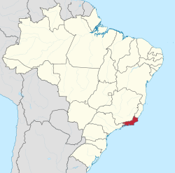
(Río de Janeiro), штат на юго-востоке Бразилии. 43,9 тыс. км2. Население 13,3 млн. человек (1995). Административный центр — Рио-де-Жанейро.
II
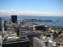
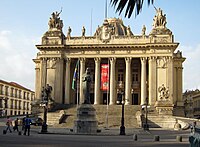
город на юго-востоке Бразилии, административный центр штата Рио-де-Жанейро. Население 5,5 млн. человек (1991), в агломерации Большой Рио-де-Жанейро 9,9 млн. человек (1995). Порт на берегу бухты Гуанабара (грузооборот свыше 15 млн. т в год). Международный аэропорт. Металлургия, машиностроение (судостроение, автосборка, электротехника), химическая, текстильная, деревообрабатывающая, пищевая и другая промышленность. Метрополитен. Важнейший научный и культурный центр страны. Университеты. АН, Филологическая академия, Национальная академия медицины. Национальный музей изящных искусств, Музей современного искусства, Индейский музей, Музей географии, музеи историко-художественный, исторический и др. Рио-де-Жанейро основан португальскими конкистадорами в январе 1502. В 1763—1822 столица вице-королевства Бразилия, в 1822—89 — Бразильской империи, в 1889—1960 — Федеративной Республики Бразилия. В центре Рио-де-Жанейро сохранились памятники архитектуры XVI—XVIII вв. Постройки архитекторов XX в. (О. Нимейера, Л. Косты, А. Э. Рейди). Крупнейший в мире стадион Мараканья (220 тыс. зрителей), известные пляжи набережной Копакабана.
Энциклопедический словарь.
2009.
Синонимы:
Смотреть что такое «Рио-де-Жанейро» в других словарях:
-
Рио-де-Жанейро — город, адм. ц. штата Рио де Жанейро, Бразилия. 1 января 1502 г. португ. мореплаватели обнаружили вход в бухту Гуанабара и, приняв его за реку, назвали по дню открытия Риу ди Жанейру река января (португ. rio река , Janeiro январь ). В 1565 г. на… … Географическая энциклопедия
-
Рио-де-Жанейро — один из красивейших городов Южной Америки, находится в юго восточной части Бразилии на берегу уникального по своей природной красоте… … Города мира
-
Рио-де-Жанейро — Рио де Жанейро. Панорама города. РИО ДЕ ЖАНЕЙРО, город (бывшая столица) в Бразилии. 5,5 млн. жителей (с пригородами 9,6 млн. жителей). Порт на берегу бухты Гуанабара Атлантического океана (один из крупнейших в Южной Америке; грузооборот свыше 15… … Иллюстрированный энциклопедический словарь
-
РИО-ДЕ-ЖАНЕЙРО — город на юго востоке Бразилии, административный центр шт. Рио де Жанейро. Население 5,5 млн. человек (1991, в агломерации Большой Рио де Жанейро 9,6 млн. человек). Порт на берегу бухты Гуанабара (грузооборот св. 15 млн. т в год). Международный… … Большой Энциклопедический словарь
-
РИО-ДЕ-ЖАНЕЙРО — (Rio de Janeiro) штат на юго востоке Бразилии. 44,3 тыс. км². Население 12,6 млн. человек (1991). Административный центр Рио де Жанейро … Большой Энциклопедический словарь
-
Рио-де-Жанейро — Риу ди Жанейру (Rio de Janeiro), город на юго востоке Бразилии, на западном берегу бухты Гуанабара; бывшая столица (1763 1960), промышленный и культурный центр страны. Один из красивейших городов Латинской Америки. Основные районы города… … Художественная энциклопедия
-
рио-де-жанейро — сущ., кол во синонимов: 2 • город (2765) • порт (361) Словарь синонимов ASIS. В.Н. Тришин. 2013 … Словарь синонимов
-
Рио-де-Жанейро — или Риo (A Cidade de Sao Sebastiuo do Rio de Janeiro) столица Соед. Штатов Бразилии, под 22 … Энциклопедия Брокгауза и Ефрона
-
Рио-де-Жанейро — У этого термина существуют и другие значения, см. Рио де Жанейро (значения). Запрос «Рио» перенаправляется сюда; см. также другие значения. Город Рио де Жанейро Rio de Janeiro … Википедия
-
Рио-де-Жанейро — I Рио де Жанейро (Rio de Janeiro) штат на Ю. В. Бразилии; в 1975 к Р. д. Ж. присоединена территория бывшего штата Гуанабара. Площадь 44,3 тыс. км2. Население 9,3 млн. чел. (1970). Административный центр г. Рио де Жанейро. Занимает видное… … Большая советская энциклопедия
|
Rio de Janeiro |
|
|---|---|
|
State |
|
| Estado do Rio de Janeiro State of Rio de Janeiro |
|
|
Flag
Coat of arms |
|
| Nickname:
Beautiful state |
|
| Motto(s):
Recte Rem Publicam Gerere (Latin) |
|
| Anthem: Hino 15 de Novembro | |
 |
|
| Coordinates (Brazil): 22°54′S 43°12′W / 22.900°S 43.200°WCoordinates: 22°54′S 43°12′W / 22.900°S 43.200°W | |
| Country | Brazil |
| Founded | December 8, 1897 |
| Capital | Rio de Janeiro |
| Government | |
| • Governor | Cláudio Castro (PL) |
| • Vice Governor | Thiago Pampolha (União) |
| • Senators | Carlos Portinho (PL) Flávio Bolsonaro (PL) Romário Faria (PL) |
| Area | |
| • Total | 43,696.1 km2 (16,871.2 sq mi) |
| • Rank | 24th |
| Population
(2010)[1] |
|
| • Total | 15,989,929 |
| • Estimate
(2021) |
17,463,349 |
| • Rank | 3rd |
| • Density | 370/km2 (950/sq mi) |
| • Rank | 2nd |
| Demonym | Fluminense |
| GDP | |
| • Year | 2017 estimate |
| • Total | US$308 billion (PPP) US$195 billion (nominal) [2] (2nd) |
| • Per capita | US$18,432 (PPP) US$11,687 (nominal) [2] (3rd) |
| HDI | |
| • Year | 2017 |
| • Category | 0.809[3] – very high (4th) |
| Time zone | UTC-3 (BRT) |
| Postal Code |
20000-000 to 28990-000 |
| ISO 3166 code | BR-RJ |
| License Plate Letter Sequence | KMF to LVE, RIO, RIP to RKV, RSG to RST |
| Website | rj.gov.br |


Rio de Janeiro (Portuguese pronunciation: [ˈʁi.u d(ʒi) ʒɐˈne(j)ɾu] (![]() listen))[a] is one of the 27 federative units of Brazil. It has the second largest economy of Brazil, with the largest being that of the state of São Paulo.[4] The state, which has 8.2% of the Brazilian population, is responsible for 9.2% of the Brazilian GDP.[5][6][7][8]
listen))[a] is one of the 27 federative units of Brazil. It has the second largest economy of Brazil, with the largest being that of the state of São Paulo.[4] The state, which has 8.2% of the Brazilian population, is responsible for 9.2% of the Brazilian GDP.[5][6][7][8]
The state of Rio de Janeiro is located within the Brazilian geopolitical region classified as the Southeast (assigned by IBGE). Rio de Janeiro shares borders with all the other states in the same Southeast macroregion: Minas Gerais (N and NW), Espírito Santo (NE) and São Paulo (SW). It is bounded on the east and south by the South Atlantic Ocean. Rio de Janeiro has an area of 43,653 km2 (16,855 sq mi). Its capital is the city of Rio de Janeiro, which was the capital of the Portuguese Colony of Brazil from 1763 to 1815, of the following United Kingdom of Portugal, Brazil and the Algarves from 1815 to 1822, and of later independent Brazil as a kingdom and republic from 1822 to 1960.
The state’s 22 largest cities are Rio de Janeiro, São Gonçalo, Duque de Caxias, Nova Iguaçu, Niterói, Campos dos Goytacazes, Belford Roxo, São João de Meriti, Petrópolis, Volta Redonda, Magé, Macaé, Itaboraí, Cabo Frio, Armação dos Búzios, Angra dos Reis, Nova Friburgo, Barra Mansa, Barra do Piraí, Teresópolis, Mesquita and Nilópolis.
Rio de Janeiro is the smallest state by area in the Southeast macroregion and one of the smallest in Brazil. It is, however, the third most populous Brazilian state, with a population of 16 million people in 2011 (making it the most densely populated state in Brazil) and has the third longest coastline in the country (after those of the states of Bahia and Maranhão).
In the Brazilian flag, the state is represented by Mimosa, the beta star in the Southern Cross (β Cru).
Demonym[edit]
The original demonym for the State of Rio de Janeiro is fluminense, from Latin flumen, fluminis, meaning «river». While carioca (from Old Tupi) is an older term, first attested in 1502, fluminense was sanctioned in 1783, twenty years after the city had become the capital of the Brazilian colonies, as the official demonym of the Royal Captaincy of Rio de Janeiro and subsequently of the Province of Rio de Janeiro. From 1783 through the Imperial Regime, carioca remained an unofficial term which other Brazilians used for the inhabitants of the city as well as the province. During the first years of the Brazilian Republic, carioca came to be the name given to those who lived in the city’s slums or a pejorative used to refer to the bureaucratic elite of the Federal District. Only when the city lost its status as Federal District (to Brasília) and became the State of Guanabara in 1960 did carioca become an official demonym along with guanabarino. In 1975, Guanabara State was incorporated into Rio de Janeiro State, becoming the present City of Rio de Janeiro. Carioca became the demonym of the city, while fluminense continues to be used for the state as a whole.
History[edit]
| Year | Pop. | ±% p.a. |
|---|---|---|
| 1872 | 1,057,696 | — |
| 1890 | 1,399,535 | +1.57% |
| 1900 | 1,737,478 | +2.19% |
| 1920 | 2,717,244 | +2.26% |
| 1940 | 3,611,998 | +1.43% |
| 1950 | 4,674,645 | +2.61% |
| 1960 | 6,709,891 | +3.68% |
| 1970 | 9,110,324 | +3.11% |
| 1980 | 11,489,797 | +2.35% |
| 1991 | 12,783,761 | +0.97% |
| 2000 | 14,367,083 | +1.31% |
| 2010 | 15,989,929 | +1.08% |
| 2021 | 17,463,349 | +0.80% |
| source:[9] |
Hereditary captainships[edit]
European presence in Rio de Janeiro dates back to 1502. Rio de Janeiro originated from parts of the captainships of de Tomé and São Vicente. Between 1555 and 1567, the territory was occupied by the French, who intended to install a colony, France Antarctique. Aiming to prevent the occupation of the Frenchmen, in March 1565, the city of Rio de Janeiro was established by Estácio de Sá.
In the 17th century, cattle raising and sugar cane cultivation stimulated the city’s progress, which was definitively assured when the port started to export gold extracted from Minas Gerais in the 18th century. In 1763, Rio de Janeiro became the capital of Colonial Brazil. With the flight of the Portuguese royal family from Portugal to Brazil in 1808, the region soon benefited from urban reforms to house the Portuguese. Chief among the promoted changes were: the transformation of agencies of public administration and justice, the creation of new churches, and hospitals, the foundation of the first bank of the country — the Banco do Brasil — and the Royal Press, with the Gazette do Rio of Janeiro. The following years witnessed the creation of the Jardim Botânico (Botanical Garden) and the Academia Real Militar.
There followed a process of cultural enhancement influenced not only by the arrival of the Royal Family, but also by the presence of European graphic artists who were hired to record the society and Brazilian natural features. During this same time, the Escola Real de Ciências, Artes e Ofícios (The Royal School of Sciences, Arts, and Works) was founded as well.
The neutral city[edit]
In 1834, the city of Rio de Janeiro was transformed into a «neutral city», remaining as capital of the state, while the captainships became provinces, with headquarters in Niterói, a neighbouring city. In 1889, the city became the capital of the Republic, the neutral city became the federal district and the province a state.[citation needed] In 1894, Petrópolis became the capital of Rio de Janeiro, until 1902 when Niterói recovered its capital status.[10] With the relocation of the federal capital to Brasília in 1960, the city of Rio de Janeiro became Guanabara State. Niterói remained the state capital for Rio de Janeiro state, while Rio de Janeiro served the same status for Guanabara.
The new state of Rio de Janeiro[edit]

In 1975, the states of Guanabara and Rio de Janeiro were merged under the name of Rio de Janeiro, with the city of Rio de Janeiro as state capital. The symbols of the former State of Rio de Janeiro were preserved, while the symbols of Guanabara were kept by the city of Rio de Janeiro.
Geography[edit]

The state is part of the Mata Atlântica biome and is made up of two distinct morphological areas: a coastal plain, known as baixada, and a plateau, which are disposed in parallel fashion from the shoreline on the Atlantic Ocean inland towards Minas Gerais.
The coastline extends 635 kilometers and is formed by the bays of Guanabara, Sepetiba, and Ilha Grande.
There are prominent slopes near the ocean, featuring also diverse environments, such as restinga vegetation, bays, lagoons and tropical forests.
Most of the state however consists of highlands, often higher than 1000 m, formed by several mountain chains like the Serra do Mar which separates Rio from the state of São Paulo. The highest point of the state, the Pico das Agulhas Negras (Black Needles Peak) is located in the Serra da Mantiqueira which forms the physical border with neighbouring Minas Gerais.
Its principal rivers are the Guandu, the Piraí, the Paraíba do Sul, the Macaé and the Muriaé.
Vegetation and animal life[edit]
Tropical forests used to cover more than 90% of the territory of Rio; large portions were devastated for urbanization and for plantations (coffee, sugar cane); preserved areas can be found in the steepest parts of the mountain chains.
The state’s tropical coast and river areas are the only remaining habitat of the golden lion tamarin.[11]
Climate[edit]

Climate types of Rio de Janeiro.
The entire state is located within the tropics (the Tropic of Capricorn passes just a few kilometers south of the state’s southernmost point) so a tropical climate is predominant. However, due to altitude, temperatures can drop to freezing point or below in some parts. Frost is not uncommon in some mountainous cities such as Teresópolis, Nova Friburgo and Petrópolis and snow has been reported occasionally in the Itatiaia National Park.
Annual mean temperatures on the coast are around 23 °C (73 °F), 26 °C (79 °F) in summer and 20 °C (68 °F) in winter. In the mountains annual mean temperatures are around 18 °C (64 °F) but can range from 20 °C (68 °F) at an elevation of 600 to 700 metres (2,000 to 2,300 ft) above sea level to 7 °C (45 °F) in the Itatiaia National Park. Summers in these areas tend to be warm but not hot, with averages around 22 °C (72 °F). Winters are quite chilly by Brazilian standards with lows around 8 to 9 °C (46 to 48 °F)
Rains tend to be concentrated in the summer (December to March) with a dry season in the winter (June to September). Most of the state receives between 1,000 and 1,500 millimetres (39 and 59 in) of rainfall in a year.
Demographics[edit]
Ethnicities of Rio de Janeiro in 2010.[12]
Pardo (mixed-race) (39.60%)
Not declared (0.02%)
According to the IBGE of 2008, there were 15,772,000 people residing in the state. The population density was 352.58 inhabitants per square kilometre (913.2/sq mi).
Urbanization: 96.9% (2004); Population growth: 1.3% (1991–2000).
The last PNAD (National Household Survey) census revealed the following numbers: 8,509,000 White people (54.2%), 5,302,000 Pardo (Multiracial) people (33.8%), 1,809,000 Black people (11.5%), 25,000 Asian people (0.2%), 19,000 Amerindian people (0.1%).[13]
People of Portuguese ancestry predominate in most of the state. The Brazilian census of 1920 showed that 39,74% of the Portuguese who lived in Brazil lived in Rio de Janeiro. Including all of the Rio de Janeiro, the proportion raised to 46,30% of the Portuguese who lived in Brazil. The numerical presence of the Portuguese was extremely high, accounting for 72% of the foreigners who lived in the capital. Portuguese born people accounted for 20,36% of the population of Rio, and those with a Portuguese father or a Portuguese mother accounted for 30,84%. In other words, native born Portuguese and their children accounted for 51,20% of the inhabitants of Rio, or a total of 267664 people in 1890.[14]
Other European ethnic groups, such as Swiss, Finnish and Germans settled mostly in the mountainous areas (Nova Friburgo, Petrópolis, etc.) and in the capital. Italians and Spaniards are also present in the capital as well as in the surrounding cities.[15][16]
People of African descent are numerous, particularly in the metropolitan area of the capital city. Those of mixed-race ancestry (tri-racials, mulatos, and some caboclos and cafuzos) make up the majority of the population in many cities. The city of Itaguaí was considered a Japanese colony in the 20th century, but many of the Asian Cariocas that once lived there moved overseas (most of them to Japan) as well to other Brazilian states like São Paulo.
Largest cities[edit]
Religion[edit]
Religion in Rio de Janeiro (2010)
Other (6.2%)
No religion (14.6%)
According to the 2010 Brazilian census, there were 7 324 315 Roman Catholics (45.8%), 4 696 906 Protestants (29.4%), 647 572 Spiritists (4%), and 2 416 303 people without religion (14.6%). There are also adherents of Islam, Judaism, Buddhism, Hinduism, esoterism, neo-paganism, afro-Brazilian religions and Asian religions. Together, the adherents of these and other minorities constitute 6.2% of Rio de Janeiro’s population.[18][19]
Rio de Janeiro is the state with the lowest percentage of Catholics in Brazil, and the state with the highest percentage of people without religion (such as atheists, and agnostics). In addition, it is the state with the highest percentage of spiritists in Brazil. The variety of denominations is a mark of the presence of religious diversity in the demographic profile of the state.
Education[edit]
The state of Rio de Janeiro has the 4th best education in Brazil, second only to the Federal District, São Paulo and Goiás.
The state has the fourth lowest illiteracy rate in Brazil, about 4% of its population. The illiteracy rate in the state is compared to countries like Singapore, Portugal, and China.[20][21]
Colleges and universities[edit]
Most of the state’s leading universities are public. The most prestigious university is the Federal University of Rio de Janeiro, regarded as the best Federal university in Brazil, and fifth best in Latin America according to the QS World University Rankings.[22][23]
Some other well-known colleges, and universities in the state:
Public[edit]
- Federal University of Rio de Janeiro (UFRJ)
- State University of Rio de Janeiro (UERJ)
- Fluminense Federal University (UFF)
- Federal University of the State of Rio de Janeiro (UNIRIO)
- Federal Rural University of Rio de Janeiro (UFRRJ)
- Military Institute of Engineering (IME-RJ)
- State University of Northern Rio de Janeiro (UENF)
- Federal Institute of Rio de Janeiro (IFRJ)
- Fluminense Federal Institute (IFF)
- Centro Universitário Estadual da Zona Oeste (UEZO)
Private[edit]

- Pontifical Catholic University of Rio de Janeiro (PUC-RIO)
- Catholic University of Petrópolis (UCP)
- Estácio De Sá University (UNESA)
- Fundação Getúlio Vargas (FGV)
- Universidade Grande Rio (UNIGRANRIO)
- Universidade Cândido Mendes (UCAM)
- University of Vassouras (USS)
- Universidade Castelo Branco (UCB)
- Universidade Santa Úrsula (USU)
- Universidade Veiga de Almeida (UVA)
- Universidade Salgado de Oliveira (UNIVERSO)[24]
Economy[edit]
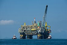
Oil platform P-51 in Rio de Janeiro
The industrial sector is the largest component of GDP at 51.6%, followed by the service sector at 47.8%. Agriculture represents 0.6% of GDP (2004). Rio de Janeiro (state) exports: petroleum 44.8%, fuel 17.5%, siderurgy 13%, chemicals 3.6%, not ferrous metals 2.8%, vehicles 2.1% (2002).
Participation in the Brazilian economy: 15.6% (2004).
There are 3,915,724 vehicles in the state (as of Jan. 2006), 10 million mobile phones, 5.3 million telephones, and 92 cities.
Culture[edit]
Carnival[edit]
The occasion of the last five days leading up to Lent is annually cause for a great explosion of joy in Rio – a round-the-clock party uniting emotions, creativity, plasticity, colours, sounds and much fantasy. It is the greatest popular party in the world, a unique record of the rich cultural melting pot typical of Brazil.

In Rio, it is celebrated in various ways, most famously through the elaborate competition of samba schools comprising thousands of dancers in each school, each of which has composed a new «enredo de samba» (samba script) for the year that is released and popularized by the time Carnaval arrives, thus already recognizable for its lyrics, themes, and rhythms by the energized audience in the bleachers thronging to see the all-night competition of one samba school after another until dawn. Each samba school consists of ‘alas’ (wings) of samba dancers costumed to carry out one aspect of the theme of the song they all sing. This event began in the 1930s as a diversion for what politicians sought to assuage as an otherwise restive populace. It came to be held on the bleacher-lined Marques du Sapucai for decades until a covered sambadrome was built in the 1980s.
In other parts of the city, Carnaval festivities include the Banda de Ipanema, a street parade of transvestite costuming that draws its throngs of revelers to the streets of Ipanema. In the city center on the final night of Carnaval, into the wee hours of Quarta Cinza (Ash Wednesday), a very different flavor of street parade is provided by Quilombo (the word given to slave refugee colonies) with authentic African costuming. For others, Carnaval is a time of clubbing in costume in more exclusive locales in the Zona Sul.
The film Black Orpheus is set in the context of Carnaval in Rio.
New Year’s Eve[edit]

In Rio de Janeiro, a globally unique New Year’s Eve celebration involves the whole city population. Local inhabitants and visitors join in flocking to the ocean to celebrate the night of the year when thanks are given and wishes are made to the goddess of the sea, Iemanja. In honor of her traditional garb, celebrants dress in white and bear gifts like flowers, especially white, and even blancmange. At midnight, beachgoers on the typically hot midsummer night, walk into the surf and cast their flowers (and wishes for the coming year) on the lapping waves to be carried out to honor the goddess (the tradition says that wishes will turn to reality if the waves take the gifts to the sea, and won’t if the gifts come back to the beach). Nearby parties, concerts and music last into the dawn, many choosing to sleep it off on the beach on New Year’s Day. In recent years, campfires and the oral tradition of shared stories around statues of Iemanja has modernized into massive fireworks displays and to a mega-concert on the famous beach of Copacabana.
Infrastructure[edit]
International airport[edit]

Rio de Janeiro-Galeão International Airport
Since August 2004, with the transfer of many flights from Santos Dumont Airport, to Rio de Janeiro-Galeão International Airport, Rio de Janeiro has second international airport of Brazil. According to data from the official Brazilian travel bureau, Embratur, nearly 40% of foreign tourists who visit Brazil choose Rio as their gateway, meaning Galeão Airport. Besides linking Rio to the rest of Brazil with domestic flights, Galeão has connections to 18 other countries. It can handle up to 15 million passengers a year in two passenger terminals. Located 20 kilometers from downtown Rio, the international airport is served by several quick access routes, such as the Linha Vermelha/Red Line and Linha Amarela/Yellow Line freeways and Avenida Brasil/Brazil Avenue, thus conveniently serving residents of the city’s southern, northern and western zones. There are special shuttle buses linking Galeão to Santos Dumont, and bus and taxi service to the rest of the city. The airport complex also has Brazil’s longest runway at 4,240 metres (13,910 ft), and one of South America’s largest and best equipped cargo logistics terminals.
Highways[edit]
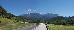
BR-116 highway in the mountainous region of Rio de Janeiro.
The main Federal highways that cross the state are:
- BR-101
- BR-116
- BR-040
- BR-354
- BR-356
- BR-393
- BR-465
- BR-493
- BR-495
Port[edit]
Construction is underway on a new Port of Açu. The port will cover 36 square miles. This USD 1.6 billion project at Sao Joao da Barra, approximately 280 kilometers from Rio de Janeiro, has been under construction since October 2007 and will be operational in 2013. It is forecast that the port will eventually handle over 63 million tons of iron ore, 10 million tons of steel products, 15 million tons of coal, 5 million tons of dry bulk and 7.5 million tons of general cargo. A breakwater damn to protect ships from ocean waves is also planned.[25]
Sports[edit]

Sports are a very popular pastime in Rio de Janeiro. The most popular is association football. Rio de Janeiro is home to four traditional Brazilian football clubs: Flamengo, Vasco, Fluminense and Botafogo. The state football league is Campeonato Carioca. The city of Rio de Janeiro hosted the 2014 FIFA World Cup. The city built a new stadium near the Maracanã, to hold 45,000 people. It was named after Brazilian ex-FIFA president João Havelange.
Other notable sports events in Rio include the MotoGP Brazilian Grand Prix and the World Beach volleyball finals. Jacarepaguá was the place of Formula One Brazilian Grand Prix into 1978-1990 and the Champ Car event into 1996–1999. WCT/WQS Surf championships were contested on the beaches from 1985 to 2001.
On 2 October 2009, Rio de Janeiro was selected to host the 2016 Olympic Games, which will be the first to be held in South America.[26] The games began in August. Two years ago, in 2014, the FIFA games were held. Much of the infrastructure was used again.
State flag[edit]
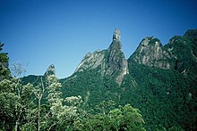
An eagle, symbol of Brazil’s royal family, appears on the state flag with the rock formation Dedo de Deus («The Finger of God») near Teresópolis in the background.
The outer part of the coat of arms represents the state’s agricultural richness, sugarcane (left) and coffee (right).
- Flags used in Rio de Janeiro over the years
-

Flag of the Captaincy of Rio de Janeiro — Kingdom of Portugal, Brazil and the Algarves (1565 – 1821).
-

Flag of the Province of Rio de Janeiro (1821 – 1889)
-

Flag of the State of Rio de Janeiro (1889–present)


Gallery[edit]
-

-
-
-
Niterói, one of the most famous and developed cities of the state
-
-

God’s Finger peak, a symbol of the state
-
-

A farm scene in the countryside of the state
-


See also[edit]
- List of Governors of Rio de Janeiro
- List of municipalities in Rio de Janeiro
- List of country subdivisions by GDP over 100 billion US dollars
Notes[edit]
- ^ In the variety of Brazilian Portuguese spoken in Rio de Janeiro, according to Larousse Concise Dictionary: Portuguese-English, 2008, p. 339 (in which the pronunciations «refletem a língua falada no Rio de Janeiro» [reflect the language as spoken in Rio de Janeiro]). The European Portuguese pronunciation is [ˈʁi.u ðɨ ʒɐˈnɐjɾu].
References[edit]
- ^ «IBGE | Biblioteca | Detalhes | Sinopse do censo demográfico : 2010 / IBGE. -«. biblioteca.ibge.gov.br. Retrieved 2022-04-03.
- ^ a b «Produto Interno Bruto do Estado do Rio de Janeiro». Retrieved 22 April 2018.
- ^ «Radar IDHM: evolução do IDHM e de seus índices componentes no período de 2012 a 2019» (PDF) (in Portuguese). PNUD Brasil. Retrieved 18 April 2019.
- ^ «Veja o PIB dos Estados brasileiros». www.faemg.org.br. Archived from the original on 2014-10-20.
- ^ Descubra quais são os 15 Estados mais ricos do Brasil
- ^ ‘The Economist’ compara economia de Estados do Brasil com países
- ^ Dados dos estados e cidades do Brasil
- ^ População dos estados do Brasil
- ^ IGBE
- ^ «Emperor Street». World Digital Library. 1860–1870. Retrieved 2013-08-24.
- ^ «Chicago Zoological Society — Golden Lion Tamarin». Archived from the original on May 7, 2008. Retrieved 2012-04-29.
{{cite web}}: CS1 maint: bot: original URL status unknown (link) - ^ «Tabela 2094: População residente por cor ou raça e religião». sidra.ibge.gov.br. Retrieved 2021-04-25.
- ^ Sistema IBGE de Recuperação Automática — SIDRA (PDF) (in Portuguese). State of Rio de Janeiro, Brazil: IBGE. 2008. ISBN 978-85-240-3919-5. Retrieved 2014-08-24.
- ^ Os lusíadas na aventura do Rio moderno. Retrieved 2014-08-24.
- ^ «A Colônia Suíça de Nova Friburgo». Multirio.rj.gov.br. Retrieved 2014-08-24.
- ^ «A COLONIZAÇÃO ALEMÃ E DE OUTRAS NACIONALIDADES». www.luteranos.com.br (in Portuguese). Archived from the original on 2007-05-22.
- ^ «Estimativas da população residente nos municípios brasileiros com data de referência em 1º de julho de 2011» [Estimates of the Resident Population of Brazilian Municipalities as of July 1, 2011] (PDF) (in Portuguese). Brazilian Institute of Geography and Statistics. 30 August 2011. Archived (PDF) from the original on 7 October 2011. Retrieved 31 August 2011.
- ^ «Censo 2010». IBGE
- ^ «Análise dos Resultados/IBGE Censo Demográfico 2010: Características gerais da população, religião e pessoas com deficiência» (PDF)
- ^ «IBGE Censo 2010». censo2010.ibge.gov.br.
- ^ «Ideb 2013: Veja a nota do ensino médio de todos os Estados brasileiros». educacao.uol.com.br (in Brazilian Portuguese).
- ^ «QS University Rankings: Latin America 2015». Top Universities.
- ^ «As 18 melhores universidades do Brasil em 2015». www.abril.com.br (in Portuguese). Archived from the original on 2015-07-20.
- ^ «Ranking de universidades — Ranking Universitário Folha — 2016». ruf.folha.uol.com.br.
- ^ Magalhaes, Luciana (April 1, 2013). «Credibility Hangs on Unfinished Port, Ambitious Project of Brazilian Billionaire Is Important Both for Nation’s Infrastructure and to Prove Doubters Wrong». Wall Street Journal.
- ^ Gibson, Owen (October 2, 2009). «Olympics 2016: Tearful Pele and weeping Lula greet historic win for Rio». The Guardian. London.
- ^ «History (Nova Friburgo)» (in Portuguese). 1 January 2014. Archived from the original on 5 December 2014. Retrieved 29 November 2014.
External links[edit]
 Media related to Rio de Janeiro (state) at Wikimedia Commons
- Official website (in Portuguese)
- State Judiciary (in Portuguese)
- State Assembly (in Portuguese)
- State University (in Portuguese and English)
- Northern State University (in Portuguese)
- State Attornery Office (in Portuguese)
- State Civil Defence (in Portuguese)
- State Military Police (in Portuguese)
- State Civil Police (in Portuguese)
|
Rio de Janeiro |
|
|---|---|
|
State |
|
| Estado do Rio de Janeiro State of Rio de Janeiro |
|
|
Flag
Coat of arms |
|
| Nickname:
Beautiful state |
|
| Motto(s):
Recte Rem Publicam Gerere (Latin) |
|
| Anthem: Hino 15 de Novembro | |
|
|
| Coordinates (Brazil): 22°54′S 43°12′W / 22.900°S 43.200°WCoordinates: 22°54′S 43°12′W / 22.900°S 43.200°W | |
| Country | Brazil |
| Founded | December 8, 1897 |
| Capital | Rio de Janeiro |
| Government | |
| • Governor | Cláudio Castro (PL) |
| • Vice Governor | Thiago Pampolha (União) |
| • Senators | Carlos Portinho (PL) Flávio Bolsonaro (PL) Romário Faria (PL) |
| Area | |
| • Total | 43,696.1 km2 (16,871.2 sq mi) |
| • Rank | 24th |
| Population
(2010)[1] |
|
| • Total | 15,989,929 |
| • Estimate
(2021) |
17,463,349 |
| • Rank | 3rd |
| • Density | 370/km2 (950/sq mi) |
| • Rank | 2nd |
| Demonym | Fluminense |
| GDP | |
| • Year | 2017 estimate |
| • Total | US$308 billion (PPP) US$195 billion (nominal) [2] (2nd) |
| • Per capita | US$18,432 (PPP) US$11,687 (nominal) [2] (3rd) |
| HDI | |
| • Year | 2017 |
| • Category | 0.809[3] – very high (4th) |
| Time zone | UTC-3 (BRT) |
| Postal Code |
20000-000 to 28990-000 |
| ISO 3166 code | BR-RJ |
| License Plate Letter Sequence | KMF to LVE, RIO, RIP to RKV, RSG to RST |
| Website | rj.gov.br |
Rio de Janeiro (Portuguese pronunciation: [ˈʁi.u d(ʒi) ʒɐˈne(j)ɾu] (![]() listen))[a] is one of the 27 federative units of Brazil. It has the second largest economy of Brazil, with the largest being that of the state of São Paulo.[4] The state, which has 8.2% of the Brazilian population, is responsible for 9.2% of the Brazilian GDP.[5][6][7][8]
listen))[a] is one of the 27 federative units of Brazil. It has the second largest economy of Brazil, with the largest being that of the state of São Paulo.[4] The state, which has 8.2% of the Brazilian population, is responsible for 9.2% of the Brazilian GDP.[5][6][7][8]
The state of Rio de Janeiro is located within the Brazilian geopolitical region classified as the Southeast (assigned by IBGE). Rio de Janeiro shares borders with all the other states in the same Southeast macroregion: Minas Gerais (N and NW), Espírito Santo (NE) and São Paulo (SW). It is bounded on the east and south by the South Atlantic Ocean. Rio de Janeiro has an area of 43,653 km2 (16,855 sq mi). Its capital is the city of Rio de Janeiro, which was the capital of the Portuguese Colony of Brazil from 1763 to 1815, of the following United Kingdom of Portugal, Brazil and the Algarves from 1815 to 1822, and of later independent Brazil as a kingdom and republic from 1822 to 1960.
The state’s 22 largest cities are Rio de Janeiro, São Gonçalo, Duque de Caxias, Nova Iguaçu, Niterói, Campos dos Goytacazes, Belford Roxo, São João de Meriti, Petrópolis, Volta Redonda, Magé, Macaé, Itaboraí, Cabo Frio, Armação dos Búzios, Angra dos Reis, Nova Friburgo, Barra Mansa, Barra do Piraí, Teresópolis, Mesquita and Nilópolis.
Rio de Janeiro is the smallest state by area in the Southeast macroregion and one of the smallest in Brazil. It is, however, the third most populous Brazilian state, with a population of 16 million people in 2011 (making it the most densely populated state in Brazil) and has the third longest coastline in the country (after those of the states of Bahia and Maranhão).
In the Brazilian flag, the state is represented by Mimosa, the beta star in the Southern Cross (β Cru).
Demonym[edit]
The original demonym for the State of Rio de Janeiro is fluminense, from Latin flumen, fluminis, meaning «river». While carioca (from Old Tupi) is an older term, first attested in 1502, fluminense was sanctioned in 1783, twenty years after the city had become the capital of the Brazilian colonies, as the official demonym of the Royal Captaincy of Rio de Janeiro and subsequently of the Province of Rio de Janeiro. From 1783 through the Imperial Regime, carioca remained an unofficial term which other Brazilians used for the inhabitants of the city as well as the province. During the first years of the Brazilian Republic, carioca came to be the name given to those who lived in the city’s slums or a pejorative used to refer to the bureaucratic elite of the Federal District. Only when the city lost its status as Federal District (to Brasília) and became the State of Guanabara in 1960 did carioca become an official demonym along with guanabarino. In 1975, Guanabara State was incorporated into Rio de Janeiro State, becoming the present City of Rio de Janeiro. Carioca became the demonym of the city, while fluminense continues to be used for the state as a whole.
History[edit]
| Year | Pop. | ±% p.a. |
|---|---|---|
| 1872 | 1,057,696 | — |
| 1890 | 1,399,535 | +1.57% |
| 1900 | 1,737,478 | +2.19% |
| 1920 | 2,717,244 | +2.26% |
| 1940 | 3,611,998 | +1.43% |
| 1950 | 4,674,645 | +2.61% |
| 1960 | 6,709,891 | +3.68% |
| 1970 | 9,110,324 | +3.11% |
| 1980 | 11,489,797 | +2.35% |
| 1991 | 12,783,761 | +0.97% |
| 2000 | 14,367,083 | +1.31% |
| 2010 | 15,989,929 | +1.08% |
| 2021 | 17,463,349 | +0.80% |
| source:[9] |
Hereditary captainships[edit]
European presence in Rio de Janeiro dates back to 1502. Rio de Janeiro originated from parts of the captainships of de Tomé and São Vicente. Between 1555 and 1567, the territory was occupied by the French, who intended to install a colony, France Antarctique. Aiming to prevent the occupation of the Frenchmen, in March 1565, the city of Rio de Janeiro was established by Estácio de Sá.
In the 17th century, cattle raising and sugar cane cultivation stimulated the city’s progress, which was definitively assured when the port started to export gold extracted from Minas Gerais in the 18th century. In 1763, Rio de Janeiro became the capital of Colonial Brazil. With the flight of the Portuguese royal family from Portugal to Brazil in 1808, the region soon benefited from urban reforms to house the Portuguese. Chief among the promoted changes were: the transformation of agencies of public administration and justice, the creation of new churches, and hospitals, the foundation of the first bank of the country — the Banco do Brasil — and the Royal Press, with the Gazette do Rio of Janeiro. The following years witnessed the creation of the Jardim Botânico (Botanical Garden) and the Academia Real Militar.
There followed a process of cultural enhancement influenced not only by the arrival of the Royal Family, but also by the presence of European graphic artists who were hired to record the society and Brazilian natural features. During this same time, the Escola Real de Ciências, Artes e Ofícios (The Royal School of Sciences, Arts, and Works) was founded as well.
The neutral city[edit]
In 1834, the city of Rio de Janeiro was transformed into a «neutral city», remaining as capital of the state, while the captainships became provinces, with headquarters in Niterói, a neighbouring city. In 1889, the city became the capital of the Republic, the neutral city became the federal district and the province a state.[citation needed] In 1894, Petrópolis became the capital of Rio de Janeiro, until 1902 when Niterói recovered its capital status.[10] With the relocation of the federal capital to Brasília in 1960, the city of Rio de Janeiro became Guanabara State. Niterói remained the state capital for Rio de Janeiro state, while Rio de Janeiro served the same status for Guanabara.
The new state of Rio de Janeiro[edit]
In 1975, the states of Guanabara and Rio de Janeiro were merged under the name of Rio de Janeiro, with the city of Rio de Janeiro as state capital. The symbols of the former State of Rio de Janeiro were preserved, while the symbols of Guanabara were kept by the city of Rio de Janeiro.
Geography[edit]
The state is part of the Mata Atlântica biome and is made up of two distinct morphological areas: a coastal plain, known as baixada, and a plateau, which are disposed in parallel fashion from the shoreline on the Atlantic Ocean inland towards Minas Gerais.
The coastline extends 635 kilometers and is formed by the bays of Guanabara, Sepetiba, and Ilha Grande.
There are prominent slopes near the ocean, featuring also diverse environments, such as restinga vegetation, bays, lagoons and tropical forests.
Most of the state however consists of highlands, often higher than 1000 m, formed by several mountain chains like the Serra do Mar which separates Rio from the state of São Paulo. The highest point of the state, the Pico das Agulhas Negras (Black Needles Peak) is located in the Serra da Mantiqueira which forms the physical border with neighbouring Minas Gerais.
Its principal rivers are the Guandu, the Piraí, the Paraíba do Sul, the Macaé and the Muriaé.
Vegetation and animal life[edit]
Tropical forests used to cover more than 90% of the territory of Rio; large portions were devastated for urbanization and for plantations (coffee, sugar cane); preserved areas can be found in the steepest parts of the mountain chains.
The state’s tropical coast and river areas are the only remaining habitat of the golden lion tamarin.[11]
Climate[edit]
Climate types of Rio de Janeiro.
The entire state is located within the tropics (the Tropic of Capricorn passes just a few kilometers south of the state’s southernmost point) so a tropical climate is predominant. However, due to altitude, temperatures can drop to freezing point or below in some parts. Frost is not uncommon in some mountainous cities such as Teresópolis, Nova Friburgo and Petrópolis and snow has been reported occasionally in the Itatiaia National Park.
Annual mean temperatures on the coast are around 23 °C (73 °F), 26 °C (79 °F) in summer and 20 °C (68 °F) in winter. In the mountains annual mean temperatures are around 18 °C (64 °F) but can range from 20 °C (68 °F) at an elevation of 600 to 700 metres (2,000 to 2,300 ft) above sea level to 7 °C (45 °F) in the Itatiaia National Park. Summers in these areas tend to be warm but not hot, with averages around 22 °C (72 °F). Winters are quite chilly by Brazilian standards with lows around 8 to 9 °C (46 to 48 °F)
Rains tend to be concentrated in the summer (December to March) with a dry season in the winter (June to September). Most of the state receives between 1,000 and 1,500 millimetres (39 and 59 in) of rainfall in a year.
Demographics[edit]
Ethnicities of Rio de Janeiro in 2010.[12]
Pardo (mixed-race) (39.60%)
Not declared (0.02%)
According to the IBGE of 2008, there were 15,772,000 people residing in the state. The population density was 352.58 inhabitants per square kilometre (913.2/sq mi).
Urbanization: 96.9% (2004); Population growth: 1.3% (1991–2000).
The last PNAD (National Household Survey) census revealed the following numbers: 8,509,000 White people (54.2%), 5,302,000 Pardo (Multiracial) people (33.8%), 1,809,000 Black people (11.5%), 25,000 Asian people (0.2%), 19,000 Amerindian people (0.1%).[13]
People of Portuguese ancestry predominate in most of the state. The Brazilian census of 1920 showed that 39,74% of the Portuguese who lived in Brazil lived in Rio de Janeiro. Including all of the Rio de Janeiro, the proportion raised to 46,30% of the Portuguese who lived in Brazil. The numerical presence of the Portuguese was extremely high, accounting for 72% of the foreigners who lived in the capital. Portuguese born people accounted for 20,36% of the population of Rio, and those with a Portuguese father or a Portuguese mother accounted for 30,84%. In other words, native born Portuguese and their children accounted for 51,20% of the inhabitants of Rio, or a total of 267664 people in 1890.[14]
Other European ethnic groups, such as Swiss, Finnish and Germans settled mostly in the mountainous areas (Nova Friburgo, Petrópolis, etc.) and in the capital. Italians and Spaniards are also present in the capital as well as in the surrounding cities.[15][16]
People of African descent are numerous, particularly in the metropolitan area of the capital city. Those of mixed-race ancestry (tri-racials, mulatos, and some caboclos and cafuzos) make up the majority of the population in many cities. The city of Itaguaí was considered a Japanese colony in the 20th century, but many of the Asian Cariocas that once lived there moved overseas (most of them to Japan) as well to other Brazilian states like São Paulo.
Largest cities[edit]
Religion[edit]
Religion in Rio de Janeiro (2010)
Other (6.2%)
No religion (14.6%)
According to the 2010 Brazilian census, there were 7 324 315 Roman Catholics (45.8%), 4 696 906 Protestants (29.4%), 647 572 Spiritists (4%), and 2 416 303 people without religion (14.6%). There are also adherents of Islam, Judaism, Buddhism, Hinduism, esoterism, neo-paganism, afro-Brazilian religions and Asian religions. Together, the adherents of these and other minorities constitute 6.2% of Rio de Janeiro’s population.[18][19]
Rio de Janeiro is the state with the lowest percentage of Catholics in Brazil, and the state with the highest percentage of people without religion (such as atheists, and agnostics). In addition, it is the state with the highest percentage of spiritists in Brazil. The variety of denominations is a mark of the presence of religious diversity in the demographic profile of the state.
Education[edit]
The state of Rio de Janeiro has the 4th best education in Brazil, second only to the Federal District, São Paulo and Goiás.
The state has the fourth lowest illiteracy rate in Brazil, about 4% of its population. The illiteracy rate in the state is compared to countries like Singapore, Portugal, and China.[20][21]
Colleges and universities[edit]
Most of the state’s leading universities are public. The most prestigious university is the Federal University of Rio de Janeiro, regarded as the best Federal university in Brazil, and fifth best in Latin America according to the QS World University Rankings.[22][23]
Some other well-known colleges, and universities in the state:
Public[edit]
- Federal University of Rio de Janeiro (UFRJ)
- State University of Rio de Janeiro (UERJ)
- Fluminense Federal University (UFF)
- Federal University of the State of Rio de Janeiro (UNIRIO)
- Federal Rural University of Rio de Janeiro (UFRRJ)
- Military Institute of Engineering (IME-RJ)
- State University of Northern Rio de Janeiro (UENF)
- Federal Institute of Rio de Janeiro (IFRJ)
- Fluminense Federal Institute (IFF)
- Centro Universitário Estadual da Zona Oeste (UEZO)
Private[edit]
- Pontifical Catholic University of Rio de Janeiro (PUC-RIO)
- Catholic University of Petrópolis (UCP)
- Estácio De Sá University (UNESA)
- Fundação Getúlio Vargas (FGV)
- Universidade Grande Rio (UNIGRANRIO)
- Universidade Cândido Mendes (UCAM)
- University of Vassouras (USS)
- Universidade Castelo Branco (UCB)
- Universidade Santa Úrsula (USU)
- Universidade Veiga de Almeida (UVA)
- Universidade Salgado de Oliveira (UNIVERSO)[24]
Economy[edit]
Oil platform P-51 in Rio de Janeiro
The industrial sector is the largest component of GDP at 51.6%, followed by the service sector at 47.8%. Agriculture represents 0.6% of GDP (2004). Rio de Janeiro (state) exports: petroleum 44.8%, fuel 17.5%, siderurgy 13%, chemicals 3.6%, not ferrous metals 2.8%, vehicles 2.1% (2002).
Participation in the Brazilian economy: 15.6% (2004).
There are 3,915,724 vehicles in the state (as of Jan. 2006), 10 million mobile phones, 5.3 million telephones, and 92 cities.
Culture[edit]
Carnival[edit]
The occasion of the last five days leading up to Lent is annually cause for a great explosion of joy in Rio – a round-the-clock party uniting emotions, creativity, plasticity, colours, sounds and much fantasy. It is the greatest popular party in the world, a unique record of the rich cultural melting pot typical of Brazil.
In Rio, it is celebrated in various ways, most famously through the elaborate competition of samba schools comprising thousands of dancers in each school, each of which has composed a new «enredo de samba» (samba script) for the year that is released and popularized by the time Carnaval arrives, thus already recognizable for its lyrics, themes, and rhythms by the energized audience in the bleachers thronging to see the all-night competition of one samba school after another until dawn. Each samba school consists of ‘alas’ (wings) of samba dancers costumed to carry out one aspect of the theme of the song they all sing. This event began in the 1930s as a diversion for what politicians sought to assuage as an otherwise restive populace. It came to be held on the bleacher-lined Marques du Sapucai for decades until a covered sambadrome was built in the 1980s.
In other parts of the city, Carnaval festivities include the Banda de Ipanema, a street parade of transvestite costuming that draws its throngs of revelers to the streets of Ipanema. In the city center on the final night of Carnaval, into the wee hours of Quarta Cinza (Ash Wednesday), a very different flavor of street parade is provided by Quilombo (the word given to slave refugee colonies) with authentic African costuming. For others, Carnaval is a time of clubbing in costume in more exclusive locales in the Zona Sul.
The film Black Orpheus is set in the context of Carnaval in Rio.
New Year’s Eve[edit]
In Rio de Janeiro, a globally unique New Year’s Eve celebration involves the whole city population. Local inhabitants and visitors join in flocking to the ocean to celebrate the night of the year when thanks are given and wishes are made to the goddess of the sea, Iemanja. In honor of her traditional garb, celebrants dress in white and bear gifts like flowers, especially white, and even blancmange. At midnight, beachgoers on the typically hot midsummer night, walk into the surf and cast their flowers (and wishes for the coming year) on the lapping waves to be carried out to honor the goddess (the tradition says that wishes will turn to reality if the waves take the gifts to the sea, and won’t if the gifts come back to the beach). Nearby parties, concerts and music last into the dawn, many choosing to sleep it off on the beach on New Year’s Day. In recent years, campfires and the oral tradition of shared stories around statues of Iemanja has modernized into massive fireworks displays and to a mega-concert on the famous beach of Copacabana.
Infrastructure[edit]
International airport[edit]
Rio de Janeiro-Galeão International Airport
Since August 2004, with the transfer of many flights from Santos Dumont Airport, to Rio de Janeiro-Galeão International Airport, Rio de Janeiro has second international airport of Brazil. According to data from the official Brazilian travel bureau, Embratur, nearly 40% of foreign tourists who visit Brazil choose Rio as their gateway, meaning Galeão Airport. Besides linking Rio to the rest of Brazil with domestic flights, Galeão has connections to 18 other countries. It can handle up to 15 million passengers a year in two passenger terminals. Located 20 kilometers from downtown Rio, the international airport is served by several quick access routes, such as the Linha Vermelha/Red Line and Linha Amarela/Yellow Line freeways and Avenida Brasil/Brazil Avenue, thus conveniently serving residents of the city’s southern, northern and western zones. There are special shuttle buses linking Galeão to Santos Dumont, and bus and taxi service to the rest of the city. The airport complex also has Brazil’s longest runway at 4,240 metres (13,910 ft), and one of South America’s largest and best equipped cargo logistics terminals.
Highways[edit]
BR-116 highway in the mountainous region of Rio de Janeiro.
The main Federal highways that cross the state are:
- BR-101
- BR-116
- BR-040
- BR-354
- BR-356
- BR-393
- BR-465
- BR-493
- BR-495
Port[edit]
Construction is underway on a new Port of Açu. The port will cover 36 square miles. This USD 1.6 billion project at Sao Joao da Barra, approximately 280 kilometers from Rio de Janeiro, has been under construction since October 2007 and will be operational in 2013. It is forecast that the port will eventually handle over 63 million tons of iron ore, 10 million tons of steel products, 15 million tons of coal, 5 million tons of dry bulk and 7.5 million tons of general cargo. A breakwater damn to protect ships from ocean waves is also planned.[25]
Sports[edit]
Sports are a very popular pastime in Rio de Janeiro. The most popular is association football. Rio de Janeiro is home to four traditional Brazilian football clubs: Flamengo, Vasco, Fluminense and Botafogo. The state football league is Campeonato Carioca. The city of Rio de Janeiro hosted the 2014 FIFA World Cup. The city built a new stadium near the Maracanã, to hold 45,000 people. It was named after Brazilian ex-FIFA president João Havelange.
Other notable sports events in Rio include the MotoGP Brazilian Grand Prix and the World Beach volleyball finals. Jacarepaguá was the place of Formula One Brazilian Grand Prix into 1978-1990 and the Champ Car event into 1996–1999. WCT/WQS Surf championships were contested on the beaches from 1985 to 2001.
On 2 October 2009, Rio de Janeiro was selected to host the 2016 Olympic Games, which will be the first to be held in South America.[26] The games began in August. Two years ago, in 2014, the FIFA games were held. Much of the infrastructure was used again.
State flag[edit]
An eagle, symbol of Brazil’s royal family, appears on the state flag with the rock formation Dedo de Deus («The Finger of God») near Teresópolis in the background.
The outer part of the coat of arms represents the state’s agricultural richness, sugarcane (left) and coffee (right).
- Flags used in Rio de Janeiro over the years
-
Flag of the Captaincy of Rio de Janeiro — Kingdom of Portugal, Brazil and the Algarves (1565 – 1821).
-
Flag of the Province of Rio de Janeiro (1821 – 1889)
-
Flag of the State of Rio de Janeiro (1889–present)
Gallery[edit]
-
-
-
-
Niterói, one of the most famous and developed cities of the state
-
-
God’s Finger peak, a symbol of the state
-
-
A farm scene in the countryside of the state
-
See also[edit]
- List of Governors of Rio de Janeiro
- List of municipalities in Rio de Janeiro
- List of country subdivisions by GDP over 100 billion US dollars
Notes[edit]
- ^ In the variety of Brazilian Portuguese spoken in Rio de Janeiro, according to Larousse Concise Dictionary: Portuguese-English, 2008, p. 339 (in which the pronunciations «refletem a língua falada no Rio de Janeiro» [reflect the language as spoken in Rio de Janeiro]). The European Portuguese pronunciation is [ˈʁi.u ðɨ ʒɐˈnɐjɾu].
References[edit]
- ^ «IBGE | Biblioteca | Detalhes | Sinopse do censo demográfico : 2010 / IBGE. -«. biblioteca.ibge.gov.br. Retrieved 2022-04-03.
- ^ a b «Produto Interno Bruto do Estado do Rio de Janeiro». Retrieved 22 April 2018.
- ^ «Radar IDHM: evolução do IDHM e de seus índices componentes no período de 2012 a 2019» (PDF) (in Portuguese). PNUD Brasil. Retrieved 18 April 2019.
- ^ «Veja o PIB dos Estados brasileiros». www.faemg.org.br. Archived from the original on 2014-10-20.
- ^ Descubra quais são os 15 Estados mais ricos do Brasil
- ^ ‘The Economist’ compara economia de Estados do Brasil com países
- ^ Dados dos estados e cidades do Brasil
- ^ População dos estados do Brasil
- ^ IGBE
- ^ «Emperor Street». World Digital Library. 1860–1870. Retrieved 2013-08-24.
- ^ «Chicago Zoological Society — Golden Lion Tamarin». Archived from the original on May 7, 2008. Retrieved 2012-04-29.
{{cite web}}: CS1 maint: bot: original URL status unknown (link) - ^ «Tabela 2094: População residente por cor ou raça e religião». sidra.ibge.gov.br. Retrieved 2021-04-25.
- ^ Sistema IBGE de Recuperação Automática — SIDRA (PDF) (in Portuguese). State of Rio de Janeiro, Brazil: IBGE. 2008. ISBN 978-85-240-3919-5. Retrieved 2014-08-24.
- ^ Os lusíadas na aventura do Rio moderno. Retrieved 2014-08-24.
- ^ «A Colônia Suíça de Nova Friburgo». Multirio.rj.gov.br. Retrieved 2014-08-24.
- ^ «A COLONIZAÇÃO ALEMÃ E DE OUTRAS NACIONALIDADES». www.luteranos.com.br (in Portuguese). Archived from the original on 2007-05-22.
- ^ «Estimativas da população residente nos municípios brasileiros com data de referência em 1º de julho de 2011» [Estimates of the Resident Population of Brazilian Municipalities as of July 1, 2011] (PDF) (in Portuguese). Brazilian Institute of Geography and Statistics. 30 August 2011. Archived (PDF) from the original on 7 October 2011. Retrieved 31 August 2011.
- ^ «Censo 2010». IBGE
- ^ «Análise dos Resultados/IBGE Censo Demográfico 2010: Características gerais da população, religião e pessoas com deficiência» (PDF)
- ^ «IBGE Censo 2010». censo2010.ibge.gov.br.
- ^ «Ideb 2013: Veja a nota do ensino médio de todos os Estados brasileiros». educacao.uol.com.br (in Brazilian Portuguese).
- ^ «QS University Rankings: Latin America 2015». Top Universities.
- ^ «As 18 melhores universidades do Brasil em 2015». www.abril.com.br (in Portuguese). Archived from the original on 2015-07-20.
- ^ «Ranking de universidades — Ranking Universitário Folha — 2016». ruf.folha.uol.com.br.
- ^ Magalhaes, Luciana (April 1, 2013). «Credibility Hangs on Unfinished Port, Ambitious Project of Brazilian Billionaire Is Important Both for Nation’s Infrastructure and to Prove Doubters Wrong». Wall Street Journal.
- ^ Gibson, Owen (October 2, 2009). «Olympics 2016: Tearful Pele and weeping Lula greet historic win for Rio». The Guardian. London.
- ^ «History (Nova Friburgo)» (in Portuguese). 1 January 2014. Archived from the original on 5 December 2014. Retrieved 29 November 2014.
External links[edit]
- Media related to Rio de Janeiro (state) at Wikimedia Commons
- Official website (in Portuguese)
- State Judiciary (in Portuguese)
- State Assembly (in Portuguese)
- State University (in Portuguese and English)
- Northern State University (in Portuguese)
- State Attornery Office (in Portuguese)
- State Civil Defence (in Portuguese)
- State Military Police (in Portuguese)
- State Civil Police (in Portuguese)
Толковый словарь русского языка. Поиск по слову, типу, синониму, антониму и описанию. Словарь ударений.
рио-де-жанейро
ЭНЦИКЛОПЕДИЧЕСКИЙ СЛОВАРЬ
Рио-де-Жанейро — I
(Río de Janeiro), штат на юго-востоке Бразилии. 43,9 тыс. км2. Население 13,3 млн. человек (1995). Административный центр — Рио-де-Жанейро.
II
город на юго-востоке Бразилии, административный центр штата Рио-де-Жанейро. Население 5,5 млн. человек (1991), в агломерации Большой Рио-де-Жанейро 9,9 млн. человек (1995). Порт на берегу бухты Гуанабара (грузооборот свыше 15 млн. т в год). Международный аэропорт. Металлургия, машиностроение (судостроение, автосборка, электротехника), химическая, текстильная, деревообрабатывающая, пищевая и другая промышленность. Метрополитен. Важнейший научный и культурный центр страны. Университеты. АН, Филологическая академия, Национальная академия медицины. Национальный музей изящных искусств, Музей современного искусства, Индейский музей, Музей географии, музеи историко-художественный, исторический и др. Рио-де-Жанейро основан португальскими конкистадорами в январе 1502. В 1763-1822 столица вице-королевства Бразилия, в 1822-89 — Бразильской империи, в 1889-1960 — Федеративной Республики Бразилия. В центре Рио-де-Жанейро сохранились памятники архитектуры XVI-XVIII вв. Постройки архитекторов XX в. (О. Нимейера, Л. Косты, А. Э. Рейди). Крупнейший в мире стадион Мараканья (220 тыс. зрителей), известные пляжи набережной Копакабана.
БОЛЬШОЙ ЭНЦИКЛОПЕДИЧЕСКИЙ СЛОВАРЬ
РИО-ДЕ-ЖАНЕЙРО — город на юго-востоке Бразилии, административный центр шт. Рио-де-Жанейро. Население 5,5 млн. человек (1991, в агломерации Большой Рио-де-Жанейро 9,6 млн. человек). Порт на берегу бухты Гуанабара (грузооборот св. 15 млн. т в год). Международный аэропорт. Металлургия, машиностроение (судостроение, автосборка, электротехническое), химическая, текстильная, деревообрабатывающая, пищевая и др. промышленность. Метрополитен. Важнейший научный и культурный центр страны. Университеты. АН, Филологическая академия, Национальная академия медицины. музеи, в т. ч. Национальный музей изящных искусств, музеи современного искусства, историко-художественный, исторический, Индейский музей, Музей географии. Рио-де-Жанейро основан португальскими конкистадорами в январе 1502. В 1763-1822 столица вице-королевства Бразилии, в 1822-89 — Бразильской империи, в 1889-1960 — Федеративной Республики Бразилии. В центре Рио-де-Жанейро памятники архитектуры 16-18 вв. Постройки архитекторов 20 в. (О. Нимейера, Л. Косты, А. Э. Рейди). Крупнейший в мире стадион Мараканья (220 тыс. зрителей), известные пляжи набережной Копакабана.
————————————
РИО-ДЕ-ЖАНЕЙРО (Rio de Janeiro) — штат на юго-востоке Бразилии. 44,3 тыс. км². Население 12,6 млн. человек (1991). Административный центр — Рио-де-Жанейро.
ИЛЛЮСТРИРОВАННЫЙ ЭНЦИКЛОПЕДИЧЕСКИЙ СЛОВАРЬ

Рио-де-Жанейро. Панорама города.
РИО-ДЕ-ЖАНЕЙРО, город (бывшая столица) в Бразилии. 5,5 млн. жителей (с пригородами 9,6 млн. жителей). Порт на берегу бухты Гуанабара Атлантического океана (один из крупнейших в Южной Америке; грузооборот свыше 15 млн. т в год); международный аэропорт. Метрополитен. Черная металлургия, машиностроение; химическая, текстильная, пищевая промышленность. Университеты. Музеи: национальный, исторический, индейский и др. Театры, в том числе муниципальный. Ботанический сад (1808). Туризм. Стадион Маракана — один из крупнейших в мире (220 тыс. зрителей). Набережная Копакабана вдоль песчаного пляжа (длина около 5 км). Известен с 1502. До середины 18 в. важнейший порт и центр работорговли в Южной Америке. С 1763 столица португальского вице-королевства Бразилия, в 1822 — 89 — Бразильской империи, в 1889 — 1960 — Республики Соединенных Штатов Бразилии. Основные городские районы разделены холмами, мысами и круто падающими к морю береговыми выступами. В северо-восточной части — барочные монастыри и церкви. В 20 в. построены многочисленные высотные здания.

Рио-де-Жанейро. Бразилия.

Рио-де-Жанейро. Вид на город с высоты птичьего полёта.

Рио-де-Жанейро. Пляжи Копакабана.

Рио-де-Жанейро. Вид на залив.
СИНОНИМЫ
сущ., кол-во синонимов: 2
ПОЛЕЗНЫЕ СЕРВИСЫ
рио-де-жанейро (город)
ЭНЦИКЛОПЕДИЧЕСКИЙ СЛОВАРЬ
РИО-ДЕ-ЖАНЕЙРО (город) — РИ́О-ДЕ-ЖАНЕ́ЙРО (Rio de Janeiro), город в Бразилии, административный центр штата Рио-де-Жанейро. Площадь 1171 кв. км, население 6,150 млн человек; в агломерации Большое Рио 11,566 млн человек (2004). Важный торгово-финансовый, промышленный и культурный центр страны. Расположен на берегу бухты Гуанабара Атлантического океана. Морской порт. Международный аэропорт Галеан на о-ве Говернадор. Метрополитен (1979). 15-километровый мост через залив.
Развиты судостроение, машиностроение, металлургическая, нефтяная, химическая, фармацевтическая, кожевенная, текстильная, деревообрабатывающая, стекольная, легкая, пищевая, табачная промышленность, алмазогранильные фабрики.
В Рио-де-Жанейро 6 университетов, крупнейший из них Федеральный университет Рио-де-Жанейро (1920), Бразильская академия наук, Национальный комитет по атомной энергии, Национальная обсерватория, 25 научно-исследовательских институтов и свыше 20 научных обществ, Бразильская академия литературы. Национальная библиотека (1810) была создана на базе Королевской библиотеки Ажуда, остатки которой были доставлены из Португалии после разрушительного Лиссабонского землетрясения 1755. Национальный музей (1818), Национальный исторический музей, Национальный музей изящных искусств (1818), Музей современного искусства, Музей географии Бразилии, Музей индейца (1953) и др. Работают «Театру мунисипал», Бразильский театр комедии, театр «Жуан Каэтану», труппы «Опиньян», «Копакабана» и др. Национальный симфонический оркестр. Актерские и музыкальные кадры готовят Национальная консерватория драматического искусства, Национальная школа музыки Бразильского университета, Бразильская консерватория, Музыкальная академия им. О. Л. Фернандиса, Национальная консерватория хорового пения и др. Город знаменит на весь мир своими карнавалами на Масленицу.
Исторический очерк
В январе 1502 португальские мореплаватели, приняв вход в бухту Гуанабара за устье большой реки, назвали это место Риу ди Жанейру (португ. — Январская река), в 1531 был построен форт, а в 1567, когда португальцы окончательно закрепились в этом районе, крепость получила название Сан-Себастьян-ду-Риу-ди-Жанейру в честь святого патрона португальского короля Себастьяна I. С 1763 столица вице-королевства Бразилия, с 1822 столица Бразильской империи, в 1889-1960 — столица республики Соединенных Штатов Бразилии.
Градостроение и архитектура
Занимает относительно узкую прибрежную полосу и склоны гор и холмов. Центр города расположен в его северо-восточной части около морского порта, центральной площади и парка Парижа, где сходятся магистрали авенида Риу-Бранку и авенида Президенти Варгас. Здесь сохранились архитектурные памятники 16-19 вв. В южной части располагаются фешенебельные жилые районы, пляж Копакабана и параллельная ему авенида Атлантика с множеством магазинов. В конце 19 — начале 20 вв. в городе строились многочисленные общественные здания в духе эклектики («Театру мунисипал», Национальный музей изящных искусств, Национальная библиотека и др.). Жилые и общественные здания и ансамбли 20 в. отмечены эффектностью объемно-пространственных композиций, смелостью конструкций, соответствием специфике рельефа и климатическим условиям. В разных районах города, а особенно на склонах гор, разбросаны «фавелы» — кварталы бедноты, где формируются команды для театрально-музыкальных состязаний во время карнавала и где ищут таланты футбольные тренеры.
Архитектурный ансамбль города органически дополняют Ботанический сад (1808), Зоологический сад, Национальный парк Тижука, другие парки, скверы и пляжи.
К архитектурным памятникам и достопримечательностям относятся монастырь Сан-Бенту (конец 16 в.), барочные церкви Носа Сеньора да Глория (1714) и Сан-Франсиску ди Пенитенсия (1772), ратуша (1743), собор Ла Канделария (1775), акведук (ныне путепровод) «Аркус ди Кариока» (1750, инж. Ф. Гомис ди Андрада), старое здание Академии художеств (1826), классицистический императорский дворец Итамарати (1856, арх. Ж. М. Ж. Ребелу). Из построек 20 в. выделяются Министерство просвещения и здравоохранения (1937-43, арх. Л. Коста, О. Нимейер (см. НИМЕЙЕР Оскар) и др.) гидроаэропорт (1938, арх. А. Корреа Лима), банк Боависта (1946, арх. О. Нимейер), жилые здания «Нова Виста», «Бристоль» и «Каледония» (1948-54, арх. Л. Коста), стадион Мараканья крупнейший в мире (на 205 тысяч мест; 1950, арх. П. Бастус и др.), Музей современного искусства (1958, арх. А. Рейди (см. РЕЙДИ Афонсу Эдуарду)), гостиница «Насионал» (1970, арх. О. Нимейер).
Среди монументов известны статуя Христа Спасителя (Сальватор) на горе Корковаду (на высоте 693 м, 1931, скульптор П. Ландовски), памятник погибшим во Второй мировой войне (1960, арх. Э. Маринью и М. Нету).
ПОЛЕЗНЫЕ СЕРВИСЫ
рио-де-жанейро (штат)
ЭНЦИКЛОПЕДИЧЕСКИЙ СЛОВАРЬ
РИО-ДЕ-ЖАНЕЙРО (штат) — РИ́О-ДЕ-ЖАНЕ́ЙРО (Rio de Janeiro), штат на юго-востоке Бразилии. Площадь 44,3 тыс км2. Население 15,0535 млн человек (2004). Административный центр — Рио-де-Жанейро (см. РИО-ДЕ-ЖАНЕЙРО (город)).
ПОЛЕЗНЫЕ СЕРВИСЫ