Морфемный разбор слова:
Однокоренные слова к слову:
Взлётно-посадочная полоса

Взлётно-посадочная полоса (ВПП) — часть аэродрома, входящая в качестве рабочей площади в состав лётной полосы. ВПП представляет собой специально подготовленную и оборудованную полосу земной поверхности с искусственным (ИВПП) или грунтовым (ГВПП) покрытием, предназначенную для обеспечения взлёта и посадки летательных аппаратов (ЛА). [1]
Содержание
Обозначение и размеры
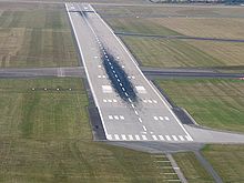
Взлётно-посадочные полосы имеют маркированный номер обычно согласно магнитному курсу, на котором они расположены. В Северной Америке ВПП зачастую нумеруются согласно истинному курсу. Значение курса округляют до десятков и делят на 10. Нулевой курс заменяют курсом 360°. Например, в новосибирском аэропорту Толмачёво ВПП-1 имеет магнитный курс 72°, её обозначение — ВПП 07. Любая полоса «направлена» одновременно в две стороны, разница между которыми равна 180°. Следовательно, противоположный курс — 252°. Таким образом, первая полоса в Толмачёво будет иметь обозначение ВПП 07/25.
Часто в аэропортах с двумя и более полосами, они располагаются параллельно — то есть на одном и том же курсе. В таких случаях к числовому обозначению добавляют буквенное — L (левая), C (центральная) и R (правая). К примеру, в чикагском аэропорту Мидуэй сразу три полосы расположены на одном курсе — 136°/316°. Соответственно, они имеют такие обозначения: ВПП 13L/31R, ВПП 13C/31C и ВПП 13R/31L. Однако в парижском аэропорту имени Де Голля все 4 ВПП имеют одинаковый курс, и во избежание путаницы обозначены как 8L/8R/9L/9R.
В эфире радиообмена между пилотами и диспетчерами полосы называют, например, «ВПП ноль два» или «ВПП один три центр».
Размеры взлётно-посадочных полос могут быть весьма различны, от совсем маленьких — 300 м в длину и 10 м в ширину, до огромных — 5,5 км в длину (Банда) и 80 метров в ширину. Самые маленькие используют для лёгкой и сверхлёгкой(СЛА) авиации. Так например для дельталёта(мотодельтаплана) достаточно 100 м разбега при взлёте и столько же для посадки. Самые крупные полосы строят в больших международных аэропортах и на авиазаводах.
Покрытие для полос используется также различное. Существуют грунтовые, гравийные, асфальтовые и бетонные полосы.
Освещение ВПП
Основная задача светового оборудования взлётно-посадочной полосы — обеспечивать безопасную посадку и взлёт воздушных судов в тёмное время суток и в сумерках, а также в условиях ограниченной видимости.
Освещение ВПП (ОВИ — огни высокой интенсивности) представляет собой световую полосу чаще всего белого цвета — стробы — длиной 500—700 метров. При заходе на посадку пилот пользуется стробами для визуального контроля положения самолёта относительно курса ВПП. Порог (торец) полосы обозначен практически сплошной линией зелёных огней, расположенной перпендикулярно полосе стробов. Осевая линия самой полосы также обозначена белыми огнями. Кромки ВПП — жёлтыми. Светосигнальное оборудование аэродрома можно разделить на группы огней, располагающиеся в определённой последовательности и легко различимые при установлении визуального контакта пилота с землей.
Группы сигнальных огней:
Разметка ВПП
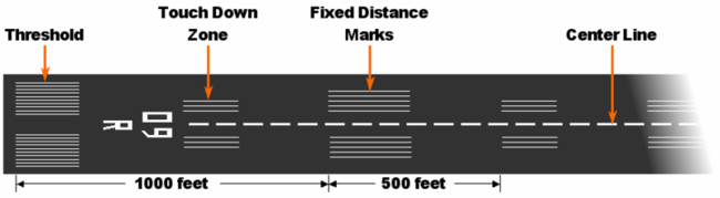
Разметка необходима прежде всего для наиболее точной и, следовательно, безопасной посадки самолёта на полосу. Разметка ВПП весьма отлична от той, что мы привыкли видеть на автодорогах.

Необходимым атрибутом разметки являются также осевая и иногда боковые линии.
Активная (рабочая) полоса
Активная полоса (рабочая полоса) — это взлётно-посадочная полоса, используемая для взлётов и (или) посадок воздушных судов в данный момент времени.
Основной фактор выбора ВПП для посадки или взлёта — это направление ветра. Из законов аэродинамики следует, что самолёт не в состоянии производить посадку или взлёт с ощутимым попутным ветром. Идеальные условия (лучше абсолютного штиля!) — это взлёт/посадка против ветра. Но ветер не всегда дует точно в противоположном направлении относительно движения самолёта. Поэтому при совершении процедур взлёта и посадки выбирается курс, наиболее отличный от направления ветра. Грубо говоря, чем ближе к положению «против ветра», тем лучше.
В аэропортах с одной или несколькими параллельными ВПП пилотам зачастую приходится сажать самолёты с боковым ветром вплоть до 90°. Но в крупных аэропортах полосы часто располагают под углом друг к другу. К примеру, в аэропорту Сан-Франциско 4 взлётно-посадочные полосы — одна пара параллельных между собой ВПП практически перпендикулярно пересекается другой парой параллельных ВПП. В аэропорту Лас-Вегаса, который также имеет 4 ВПП, угол между 2-мя парами параллельных полос составляет 60°. А в крупнейшем аэропорту Чикаго — О’Хара — 6 ВПП в трёх разных направлениях. Такая конфигурация полос зачастую облегчает жизнь пилотам и диспетчерам. Но и тут есть свои недостатки — сам факт пересечения полос уже несет в себе определённую опасность.
В аэропортах с двумя или более полосами часто применяют практику использования одной полосы для взлёта, другой — для посадки. Так, в московском Шереметьево ВПП 07R/25L используют в основном только для взлёта, а 07L/25R — для посадки. Однако в связи с близостью полос выполнять эти операции одновременно не допускается (одним из условий разрешения на совместную эксплуатацию параллельных ВПП является выполнение требования: расстояние между полосами должно быть более 1,5—2 км).
Аэропорты Домодедово и Пулково — единственные в России аэропорты, позволяющие использовать обе ВПП независимо и одновременно для взлета и посадки (режим ВП — взлёт-посадка). При этом аэропорт Домодедово в 2010 году сертифицирован на выполнение параллельных операций ВВ (взлёт-взлёт).
Сообщать экипажам самолётов номер активной (рабочей) полосы (а также погоду — скорость и направление ветра у поверхности земли, видимость, облачность, температуру воздуха, давление и т. п.) в небольших аэропортах — обязанность авиадиспетчера, а в крупных аэропортах это осуществляется с помощью системы автоматического радиовещания метеорологической информации АТИС.
Источник
взлетно-посадочная полоса
1 взлетно-посадочная полоса
2 взлетно-посадочная полоса
3 взлетно-посадочная полоса
4 взлетно-посадочная полоса
5 взлетно-посадочная полоса
6 взлетно-посадочная полоса
7 взлетно-посадочная полоса
8 взлетно-посадочная полоса
9 взлетно-посадочная полоса
10 взлетно-посадочная полоса
11 взлетно-посадочная полоса
12 взлетно-посадочная полоса
13 взлетно-посадочная полоса
14 взлетно-посадочная полоса
15 ВПП
См. также в других словарях:
взлетно-посадочная полоса — ВПП Часть аэродрома, предназначенная для разбега при взлете и пробега после посадки воздушных судов. [ФАП от 31 марта 2002] Тематики авиационные правила Синонимы ВПП … Справочник технического переводчика
Взлетно-посадочная полоса — 2) взлетно посадочная полоса (далее ВПП) определенный прямоугольный участок сухопутного аэродрома, подготовленный для посадки и взлета воздушных судов;. Источник: Приказ Минпромторга РФ от 30.12.2009 N 1215 Об утверждении нормативных… … Официальная терминология
Взлетно-посадочная полоса — ВПП 31 аэропорта Рузыне, Прага Взлётно посадочная полоса (ВПП) часть аэродрома, входящая в качестве рабочей площади в состав лётной полосы. ВПП представляет собой специально подготовленную и оборудованную полосу земной поверхности с искуственным… … Википедия
Взлетно-посадочная полоса — (ВПП) специально подготовленный и оборудованный участок на аэродроме, позволяющий производить на нем взлет и посадку самолетов. В зависимости от характера оборудованное™ ВПП может быть с естественным и искусственным покрытием. К… … Краткий словарь оперативно-тактических и общевоенных терминов
Взлетно-посадочная полоса (ВПП) — часть ЛП, специально подготовленная и оборудованная для взлета и посадки воздушных судов. ВПП может иметь искусственное покрытие (ИВПП) или грунтовое (ГВПП). Источник: СНиП 32 03 96: Аэродромы 3.4 взлетно посадочная полоса (ВПП): Часть ЛП,… … Словарь-справочник терминов нормативно-технической документации
Взлетно-посадочная полоса необорудованная — 11) необорудованная взлетно посадочная полоса ВПП, предназначенная для воздушных судов, выполняющих визуальный заход на посадку;. Источник: Приказ Минпромторга РФ от 30.12.2009 N 1215 Об утверждении нормативных методических документов,… … Официальная терминология
Взлетно-посадочная полоса оборудованная — 12) оборудованная взлетно посадочная полоса один из следующих типов ВПП, предназначенных для воздушных судов, выполняющих заход на посадку по приборам: а) ВПП, оборудованная для неточного захода на посадку ВПП, оборудованная визуальными… … Официальная терминология
Взлетно-посадочная полоса главная — 13. Главная ВПП ВПП на аэродроме расположенная, как правило, в направлении господствующих ветров и имеющая наибольшую длину в стандартных условиях. Источник: Приказ Минпромторга РФ от 30.12.2009 N 1215 Об утверждении нормативных методических… … Официальная терминология
предпочтительная по шуму взлетно-посадочная полоса — предпочтительная по шуму ВПП Взлетно посадочная полоса многополосового аэродрома, при использовании которой шумовое воздействие на население, проживающее вблизи данного аэропорта, минимально. [ГОСТ 26120 84] Тематики акустика авиационная… … Справочник технического переводчика
Источник
Правописание «в аэропорту»: верное окончание, как склоняется и употребляется
Слово «аэропорт» по грамматике не вполне обычное для русского языка: оно имеет так называемый местный падеж, который, как и предложный, употребляется только с предлогом, причём одним-единственным – «в». Поэтому, если имеется в виду место пребывания, то правильно пишется «в аэропорту» : «встречу в аэропорту»; «работаю в аэропорту», и т.п. Ударение в таких случаях падает на «у», то есть на окончание: в аэропорту́. Кроме того, в местном падеже между предлогом и словом, к которому он относится, никакие другие слова не вставляются.
Грамматика
Слово «аэропорт» – одушевлённое имя существительное мужского рода 2-го склонения. Постановка ударения и разделение переносами аэ-ро-по́рт. Падежные формы:
Значение
Существительное «аэропорт» в русском языке употребляется в обще-специальном и специальном значениях:
Примечание: предприятия сельхозавиации и занятые нерегулярными перевозками аэропортами не являются; они – аэродромы, взлетно-посадочные площадки, крупные – гражданские авиабазы.
О местном падеже
Необходимость местного падежа в русском языке – предмет спорный. И с точки зрения фонетики (по лёгкости произношения), и по орфографии (по простоте правописания) удобнее было бы писать предложный падеж как местный, выделив в нём отдельную форму для предлогов «о» и «об» с окончанием «е», тем более, что слов, требующих местного падежа, в русском языке очень мало. Будем надеяться, что лингвисты когда-нибудь да разберутся окончательно в этом вопросе.
Автор: Садов Артур Александрович, лингвист-типолог
Источник
Поиск ответа
Ответ справочной службы русского языка
Словари лучше использовать в соответствии с их «специализацией». Например, в том, что касается правописания, рекомендации толкового словаря имеют меньшую силу, чем орфографического.
Кроме того, полезно почитать о принципах составления конкретного словаря. Так, словарь «Русское словесное ударение» М. В. Зарвы ставит целью дать единственный вариант ударения, и его рекомендации довольно строги (подробнее об этом написано здесь). Орфографический словарь РАН в этом смысле более демократичен: в нем указаны в том числе варианты, характерные для непринужденной речи (при этом дикторам радио и телевидения в работе эти варианты лучше не употреблять).
Поэтому, если вы настроены следовать самым строгим нормам ударения, ориентируйтесь на «Русское словесное ударение», но если в непринужденной речи вы используете другие варианты из орфографического словаря, это тоже не будет ошибкой.
Также о словарях см. вопросы 292114 и 283908.
Ответ справочной службы русского языка
В значении ‘очень много, бесчисленное множество’ употребляется сочетание видимо-невидимо. В заголовке лучше поставить тире: Видео – невидимо.
Ответ справочной службы русского языка
Оба варианта правильны. При этом в некоторых словарях они указаны как равноправные, в некоторых – предпочтение отдается ударению полос у (при указании на допустимость варианта п о лосу ).
Ответ справочной службы русского языка
Указанные запятые не требуются.
Ответ справочной службы русского языка
Ответ справочной службы русского языка
Допустимы оба варианта, предпочтительно: полос у (такое ударение соответствует строгой литературной норме).
Ответ справочной службы русского языка
Ответ справочной службы русского языка
Подскажите ударение в слове «полоса» в словочетании «на встречную полосу «
Ответ справочной службы русского языка
Корректны два варианта: _ пОлосу _ и _ полосУ _.
И в третий раз 🙂 Подскажите, корректно ли составлено следующее предложение: «Чтобы просмотреть оставшуюся информацию, необходимо использовать полосу прокрутки (scrollbar): каждое окно имеет вертикальную и горизонтальную полосу прокрутки». Интересует адекватность двоеточия перед фрагментом, ранее заключавшемся в скобки. Спасибо. P.S. Почему не отвечаем?
Ответ справочной службы русского языка
Ответ справочной службы русского языка
Ответ справочной службы русского языка
Источник
Теперь вы знаете какие однокоренные слова подходят к слову Как правильно пишется взлетно посадочная полоса, а так же какой у него корень, приставка, суффикс и окончание. Вы можете дополнить список однокоренных слов к слову «Как правильно пишется взлетно посадочная полоса», предложив свой вариант в комментариях ниже, а также выразить свое несогласие проведенным с морфемным разбором.
Толковый словарь русского языка. Поиск по слову, типу, синониму, антониму и описанию. Словарь ударений.
взлётно-посадочный
ТОЛКОВЫЙ СЛОВАРЬ ОЖЕГОВА
ВЗЛЁТНО-ПОСА́ДОЧНЫЙ, -ая, -ое. Предназначенный для взлёта и посадки летательных аппаратов. Взлётно-посадочная полоса.
СЛИТНО. РАЗДЕЛЬНО. ЧЕРЕЗ ДЕФИС
ОРФОГРАФИЧЕСКИЙ СЛОВАРЬ
СЛОВАРЬ УДАРЕНИЙ
СИНОНИМЫ
прил., кол-во синонимов: 1
МОРФЕМНО-ОРФОГРАФИЧЕСКИЙ СЛОВАРЬ
вз/лёт/н/о/-по/са́д/оч/н/ый.
ПОЛЕЗНЫЕ СЕРВИСЫ
взлетно-посадочный
СИНОНИМЫ
прил., кол-во синонимов: 2
ПОЛЕЗНЫЕ СЕРВИСЫ
Содержание
- 1 Русский
- 1.1 Тип и синтаксические свойства сочетания
- 1.2 Произношение
- 1.3 Семантические свойства
- 1.3.1 Значение
- 1.3.2 Синонимы
- 1.3.3 Антонимы
- 1.3.4 Гиперонимы
- 1.3.5 Гипонимы
- 1.4 Этимология
- 1.5 Перевод
- 1.6 Библиография
Русский[править]
Тип и синтаксические свойства сочетания[править]
взлётно-посадочная полоса полоса
Устойчивое сочетание (термин). Используется в качестве именной группы.
Произношение[править]
- МФА: [ˌvzlʲɵtnə pɐˈsadət͡ɕnəɪ̯ə pəɫɐˈsa]
Семантические свойства[править]

Значение[править]
- авиац. часть аэродрома, специально подготовленная и оборудованная полоса земной поверхности с искусственным или грунтовым покрытием, предназначенная для обеспечения взлёта и посадки летательных аппаратов ◆ Отсутствует пример употребления (см. рекомендации).
Синонимы[править]
Антонимы[править]
Гиперонимы[править]
Гипонимы[править]
Этимология[править]
Перевод[править]
| Список переводов | |
|
Библиография[править]
Содержание
- 1 Русский
- 1.1 Тип и синтаксические свойства сочетания
- 1.2 Произношение
- 1.3 Семантические свойства
- 1.3.1 Значение
- 1.3.2 Синонимы
- 1.3.3 Антонимы
- 1.3.4 Гиперонимы
- 1.3.5 Гипонимы
- 1.4 Этимология
- 1.5 Перевод
- 1.6 Библиография
Русский
Тип и синтаксические свойства сочетания
взлётно-посадочная полоса полоса
Устойчивое сочетание (термин). Используется в качестве именной группы.
Произношение
- МФА: [ˌvzlʲɵtnə pɐˈsadət͡ɕnəɪ̯ə pəɫɐˈsa]
Семантические свойства
- авиац. часть аэродрома, специально подготовленная и оборудованная полоса земной поверхности с искусственным или грунтовым покрытием, предназначенная для обеспечения взлёта и посадки летательных аппаратов ◆ Отсутствует пример употребления (см. рекомендации).
Синонимы
Антонимы
Гиперонимы
Гипонимы
Этимология
Перевод
| Список переводов | |
|
- семантике
- этимологии
Общепринятые правила
В частности, следует уточнить сведения о:
(См. ).
Библиография
Как правильно пишется слово «ВПП»
ВПП
ВПП [вэпэпэ́], нескл., ж. (сокр.: взлетно-посадочная полоса)
Источник: Орфографический
академический ресурс «Академос» Института русского языка им. В.В. Виноградова РАН (словарная база
2020)
Делаем Карту слов лучше вместе

Привет! Меня зовут Лампобот, я компьютерная программа, которая помогает делать
Карту слов. Я отлично
умею считать, но пока плохо понимаю, как устроен ваш мир. Помоги мне разобраться!
Спасибо! Я стал чуточку лучше понимать мир эмоций.
Вопрос: плещущийся — это что-то нейтральное, положительное или отрицательное?
Предложения со словом «впп»
- – ВПП на аэродроме перекрыта грузовиками в нескольких местах, самолёту не сесть.
- ВПП была сделана не по советской технологии.
- В этом исследовании применялась диета, содержащая много растительных продуктов с высокой плотностью питательных веществ (ВПП), в которую входили продукты со значительным содержанием микронутриентов на калорию.
- (все предложения)
Отправить комментарий
Смотрите также
1. авиац. сокр. к взлётно-посадочная полоса
Все значения слова «ВПП»
-
– ВПП на аэродроме перекрыта грузовиками в нескольких местах, самолёту не сесть.
-
ВПП была сделана не по советской технологии.
-
В этом исследовании применялась диета, содержащая много растительных продуктов с высокой плотностью питательных веществ (ВПП), в которую входили продукты со значительным содержанием микронутриентов на калорию.
- (все предложения)
ВЗЛЁТНО-ПОСА́ДОЧНАЯ ПОЛОСА́ (ВПП), часть аэродрома, входящая в состав лётного поля, специально подготовленная и оборудованная для взлёта и посадки воздушных судов. Она может быть с искусственным покрытием (гравийное, асфальтовое, железобетонные, металлические листовые полосы и палубы авианесущих кораблей) и грунтовой. В пределах ВПП расположены воздушные участки взлётной дистанции (расстояние по горизонтали, проходимое самолётом от линии старта до точки набора высоты) и посадочной дистанции (расстояние по горизонтали, проходимое самолётом от момента пересечения входной кромки ВПП и до полной остановки после пробега) с некоторым запасом по длине.
Длина ВПП определяется взлётно-посадочными характеристиками самолёта, при этом учитываются возможные отклонения в технике пилотирования при эксплуатации самолёта на конкретном аэродроме. ВПП аэродромов, находящихся в высокогорных регионах или в регионах с высокой температурой воздуха, имеют увеличенную длину, т. к. атмосферное давление и температура наружного воздуха являются факторами, влияющими на работу двигателей (тягу) и длину разбега. Для обеспечения безопасности при выкатывании самолёта за пределы ВПП при прерванном взлёте или аварийной посадке существуют примыкающие к ВПП концевые полосы безопасности. ВПП может быть оборудована радиотехническими средствами, которые в сочетании с бортовым оборудованием летательного аппарата (ЛА) обеспечивают успешное выполнение посадки в автоматическом режиме или при частичном участии пилотов. Потребная для базирования длина ВПП определяется как максимальная из суммы длин разбега и лётной дистанции и длин посадочной дистанции и пробега исходя из условия отказа одного двигателя. При отказе возможны два случая, связанных с решением пилота: продолжать взлёт или прервать его. В первом случае пилот применяет все средства для увеличения (форсирования) тяги работающих двигателей, чтобы выполнить продолженный взлёт. Во втором случае при решении о прекращении взлёта пилот использует все средства – аэродинамическое торможение, реверс тяги, тормозной парашют и т. д. для гашения скорости и реализует прерванный взлёт. Главным критерием выбора является скорость принятия решения, то есть скорость разбега, при которой в случае отказа одного двигателя возможно как безопасное прекращение, так и безопасное продолжение взлёта.
Размер ВПП зависит от лётно-технических характеристик (ЛТХ) воздушного судна, продольного уклона и сцепных качеств поверхности, состояния атмосферы (температура, плотность и давление воздуха) в районе аэродрома. Ширина ВПП определяется колеёй шасси и радиусами исходя из условий разворота на 180о воздушного судна на ВПП. В технических описаниях воздушных судов параметры взлётно-посадочных дистанций даются применительно к международной стандартной атмосфере. ВПП имеют маркированный номер обычно согласно магнитному курсу, на котором они расположены. Значение градусов округляют до десятков. Если угол ориентации 42о, а плюс 180о будет 220о, то обозначение полосы ВПП 04/22.
Освещение ВПП. Основная задача светового оборудования взлётно-посадочной полосы – обеспечивать безопасную посадку и взлёт воздушных судов в тёмное время суток и в сумерках, а также в условиях ограниченной видимости. Освещение ВПП (огни высокой интенсивности) представляет собой световую полосу чаще всего белого цвета. Светосигнальное оборудование аэродрома состоит из различных групп огней, располагающихся в определённой последовательности и легко различимых при установлении визуального контакта пилота с землёй. В состав группы сигнальных огней входят: огни приближения постоянного и импульсного излучения, огни световых горизонтов, входные огни, огни знака приземления, ограничительные огни (красный свет), огни зоны приземления, боковые огни, глиссадные огни, посадочные огни (жёлтый), огни концевой полосы безопасности (осевые и центральные огни излучают белый свет, а боковые огни – красный), осевые огни ВПП, огни быстрого схода, боковые и осевые рулёжные огни (синий свет, а осевые – зелёный), стоп-огни (красный), предупредительные (жёлтый), заградительные огни (красный), аэродромные световые указатели.
Длина ВПП является определяющим элементом при установлении класса аэродрома. В соответствии с руководящими документами Международной организации гражданской авиации (ИКАО) классификация аэродромов осуществляется по кодовому обозначению. Кодовое обозначение состоит из двух элементов. Элемент 1 является номером, основанным на длине лётной полосы, а элемент 2 является буквой, соответствующей размаху крыла самолёта и расстоянию между внешними колёсами основного шасси в соответствии с таблицами 1, 2:
Таблица 1. Кодовый элемент 1
| Кодовый номер | Длина ВПП |
|---|---|
| 1 | < 800 м |
| 2 | 800–1200 м |
| 3 | 1200–1800 м |
| 4 | > 1800 м |
Таблица 2. Кодовый элемент 2
| Кодовая буква | Размах крыла | Колея основного шасси |
|---|---|---|
| A | < 15 м | < 4,5 м |
| B | 15 – 24 м | 4,6 – 6 м |
| C | 24 – 36 м | 6 – 9 м |
| D | 36 – 52 м | 9 – 14 м |
| E | 52 – 60 м | 9 – 14 м |
Например, самолёт Ил-96-300 с расчётной длиной взлёта при стандартных атмосферных условиях 2380 м, размахом крыла 57,66 м и расстоянием между внешними колёсами основного шасси 10,0 м соответствует по классификации аэродрому 4Е.
Классификация аэродромов в России отличается от международной.
По длине ВПП и несущей способности покрытия аэродромы разделяются на 6 классов: А – 3200 × 60; Б – 2600 × 45; В – 1800 × 42; Г – 1300 × 35; Д – 1000 × 28; Е – 500 × 21.
По взлётной массе принимаемых самолётов: вне класса (без ограничения массы) – Ан-124, Ан-225, А380 и т. п.; 1-го класса (75 т и более) – Ту-154, Ил-62, Ил-76 и т. п.; 2-го класса (от 30 до 75 т) – Ан-12, Як-42, Ту-134 и т. п.; 3-го класса (от 10 до 30 т) – Ан-24, Ан-26, Ан-72, Ан-140, Як-40 и т. п.; 4-го класса (до 10 т) – Ан-2, Ан-3Т, Ан-28, Ан-38, Л-410, М-101Т и т. п. У аэродромов вне класса длина ВПП составляет обычно 3500 – 4000 м, 1-го класса – 3000–3200 м, 2-го класса – 2000–2700 м, 3-го класса – 1500–1800 м, 4-го класса – 600–1200 м. Гражданские аэродромы 3-го и 4-го класса относятся к аэродромам местных воздушных линий (МВЛ). Таким образом, 1-й класс примерно соответствует классу А; 2-й класс – Б; 3-й класс – В и Г; 4-й класс – Д. К классу Е относятся полевые и временные аэродромы, посадочные площадки.
Самые длинные ВПП в мире: грунтовая ВПП 17/35 на авиабазе Эдвардс (США), расположенная на поверхности высохшего озера Роджерс – 11 917×297 м; ВПП в аэропорту города Чамдо (КНР) – 5500 м; ВПП на аэродроме Раменское (ЛИИ им. М. М. Громова, Россия) – 5403×120 м; на аэродроме Ульяновск-Восточный (Россия) – 5000×105 м, т. е. в лётно-исследовательских комплексах.
Самые короткие используются для самолётов вертикального взлёта и посадки; по размерам площадь такой ВПП соизмерима с плановой проекцией самолёта.
В одном аэропорту может быть одна (Благовещенск, Байконур–Крайний), две (Шереметьево, Домодедово, Внуково, Сочи), три (Цюрих), четыре (Владивосток, Франкфурт-на-Майне, Париж–Шарль-де-Голь), шесть (Чикаго–О’Хара) ВПП. Полосы располагают так, чтобы взлёт и посадка осуществлялись максимально против ветра и имели свободные подходы.
Независимыми являются ВПП, обеспечивающие безопасность одновременного использования полос в режиме чередующихся взлётов и посадок. Как правило, это две параллельные ВПП на расстоянии не менее 1300 м, с расположенным между ними аэровокзальным комплексом. Максимальной пропускной способностью обладает компоновка четырёх попарно параллельных полос.
Зависимыми считаются ВПП, одновременная лётная работа на которых допускается лишь с учётом увязки взлётов и посадок на обоих ВПП по времени.
Специализированными считаются ВПП, предназначенные для выполнения однотипных лётных операций, т. е. только взлётов или только посадок.
Минимальный интервал времени между последовательными взлётами или посадками называется временем занятости ВПП (например? менее 45 с).

Схема взлёта (а) и аварийной посадки (б) самолёта на взлётно-посадочную полосу: ВПП – взлётно-посадочная полоса; КПБ – концевая полоса безопасности; ЛП – лётная полоса.
Активная полоса (рабочая полоса) – это взлётно-посадочная полоса, используемая для взлётов и (или) посадок воздушных судов в данный момент времени (рис.)
Разметка ВПП необходима для точной и безопасной посадки самолёта на полосу и включает: концевую полосу безопасности (предназначена для защиты поверхности земли от обдувания мощными струями выхлопов реактивных двигателей, а также для случаев выкатывания за ВПП; летательным аппаратам запрещено находиться на КПБ, потому что её поверхность не рассчитана на их вес); перемещённый порог, либо смещённый торец (зона ВПП, где разрешено руление, разбег и пробег летательных аппаратов, но не посадка); порог, либо торец (начало ВПП, обозначает начало места, где можно приземляться; порог сделан таким образом, чтобы быть заметным издалека, количество линий зависит от ширины ВПП), маркированный номером (если необходимо, буква Л/L – левая, П/R – правая, Ц/С – центральная); зона приземления (начинается в 300 м от порога ВПП); отметки фиксированного расстояния (располагаются через 150 м, при идеальной посадке пилот глазами «удерживает» зону приземления, и касание происходит непосредственно в зоне посадки.), осевая и иногда боковые линии.
Несущая способность искусственного покрытия, предназначенного для воздушных судов с массой на перроне (стоянке) более 5700 кг, определяется по методу классификационное число воздушного судна – классификационное число покрытия (АСN-РСN) с представлением всех следующих данных: классификационное число покрытия (РСN); тип покрытия для определения АСN-РСN; категория прочности грунтового основания; категория максимально допустимого давления в пневматике или величина максимально допустимого давления в пневматике; метод оценки АСN воздушного судна определяется в соответствии со стандартными процедурами, связанными с методом АСN-РСN. Представленное классификационное число покрытия (РСN) показывает, что воздушные суда с классификационным числом воздушного судна (АСN), равным представленному РСN или менее, могут использовать это покрытие с учётом любых ограничений на давление в пневматике или полную полётную массу указанного типа воздушного судна (указанных типов воздушных судов).
This article is about the aircraft takeoff and landing area. For other uses, see Runway (disambiguation).
«Landing strip» redirects here. For the pubic hairstyle, see Bikini waxing.
Not to be confused with Roll way.


An MD-11 at one end of a runway
According to the International Civil Aviation Organization (ICAO), a runway is a «defined rectangular area on a land aerodrome prepared for the landing and takeoff of aircraft».[1] Runways may be a man-made surface (often asphalt, concrete, or a mixture of both) or a natural surface (grass, dirt, gravel, ice, sand or salt). Runways, as well as taxiways and ramps, are sometimes referred to as «tarmac», though very few runways are built using tarmac. Takeoff and landing areas defined on the surface of water for seaplanes are generally referred to as waterways. Runway lengths are now commonly given in meters worldwide, except in North America where feet are commonly used.[2]
History[edit]
In 1916, in a World War I war effort context, the first concrete-paved runway was built in Clermont-Ferrand in France, allowing local company Michelin to manufacture Bréguet Aviation military aircraft.
In January 1919, aviation pioneer Orville Wright underlined the need for «distinctly marked and carefully prepared landing places, [but] the preparing of the surface of reasonably flat ground [is] an expensive undertaking [and] there would also be a continuous expense for the upkeep.»[3]
Headings[edit]
For fixed-wing aircraft, it is advantageous to perform takeoffs and landings into the wind to reduce takeoff or landing roll and reduce the ground speed needed to attain flying speed. Larger airports usually have several runways in different directions, so that one can be selected that is most nearly aligned with the wind. Airports with one runway are often constructed to be aligned with the prevailing wind. Compiling a wind rose is in fact one of the preliminary steps taken in constructing airport runways.[4] Note that wind direction is given as the direction the wind is coming from: a plane taking off from runway 09 faces east, into an «east wind» blowing from 090°.
Originally in the 1920s and 1930s, airports and air bases (particularly in the United Kingdom) were built in a triangle-like pattern of three runways at 60° angles to each other. The reason was that back then aviation was only starting, and as a result although it was known that winds affect runway distance required, etc. not much was known about wind behaviour. As a result, three runways in a triangle-like pattern were built, and the runway with the heaviest traffic on it would eventually expand into an airport’s main runway, while the other two runways would be either abandoned or converted into taxiways.[5] For example Bristol Airport has only one runway—09/27 (9/27)—and two taxiways that form a ‘V’ which may have been runways on the original 1930s RAF Lulsgate Bottom airbase.[citation needed]
Naming[edit]


Font and size of numbers and letters
Runways are named by a number between 01 and 36, which is generally the magnetic azimuth of the runway’s heading in decadegrees. This heading differs from true north by the local magnetic declination. A runway numbered 09 points east (90°), runway 18 is south (180°), runway 27 points west (270°) and runway 36 points to the north (360° rather than 0°).[6] When taking off from or landing on runway 09, a plane is heading around 90° (east). A runway can normally be used in both directions, and is named for each direction separately: e.g., «runway 15» in one direction is «runway 33» when used in the other. The two numbers differ by 18 (= 180°). For clarity in radio communications, each digit in the runway name is pronounced individually: runway one-five, runway three-three, etc. (instead of «fifteen» or «thirty-three»).

FAA airport diagram at O’Hare International Airport. The two 14/32 runways go from upper left to lower right, the two 4/22 runways go from lower left to upper right, and the two 9/27 and three 10/28 runways are horizontal.
A leading zero, for example in «runway zero-six» or «runway zero-one-left», is included for all ICAO and some U.S. military airports (such as Edwards Air Force Base). However, most U.S. civil aviation airports drop the leading zero as required by FAA regulation.[7] This also includes some military airfields such as Cairns Army Airfield. This American anomaly may lead to inconsistencies in conversations between American pilots and controllers in other countries. It is very common in a country such as Canada for a controller to clear an incoming American aircraft to, for example, runway 04, and the pilot read back the clearance as runway 4. In flight simulation programs those of American origin might apply U.S. usage to airports around the world. For example, runway 05 at Halifax will appear on the program as the single digit 5 rather than 05.
Military airbases may include smaller paved runways known as «assault strips» for practice and training next to larger primary runways.[8] These strips eschew the standard numerical naming convention and instead employ the runway’s full three digit heading; examples include Dobbins Air Reserve Base’s Runway 110/290 and Duke Field’s Runway 180/360.[9][10]
Runways with non-hard surfaces, such as small turf airfields and waterways for seaplanes, may use the standard numerical scheme or may use traditional compass point naming, examples include Ketchikan Harbor Seaplane Base’s Waterway E/W.[11][12] Airports with unpredictable or chaotic water currents, such as Santa Catalina Island’s Pebbly Beach Seaplane Base, may designate their landing area as Waterway ALL/WAY to denote the lack of designated landing direction.[13][12]
Letter suffix[edit]

If there is more than one runway pointing in the same direction (parallel runways), each runway is identified by appending left (L), center (C) and right (R) to the end of the runway number to identify its position (when facing its direction)—for example, runways one-five-left (15L), one-five-center (15C), and one-five-right (15R). Runway zero-three-left (03L) becomes runway two-one-right (21R) when used in the opposite direction (derived from adding 18 to the original number for the 180° difference when approaching from the opposite direction). In some countries, regulations mandate that where parallel runways are too close to each other, only one may be used at a time under certain conditions (usually adverse weather).
At large airports with four or more parallel runways (for example, at Chicago O’Hare, Los Angeles, Detroit Metropolitan Wayne County, Hartsfield-Jackson Atlanta, Denver, Dallas–Fort Worth and Orlando), some runway identifiers are shifted by 1 to avoid the ambiguity that would result with more than three parallel runways. For example, in Los Angeles, this system results in runways 6L, 6R, 7L, and 7R, even though all four runways are actually parallel at approximately 69°. At Dallas/Fort Worth International Airport, there are five parallel runways, named 17L, 17C, 17R, 18L, and 18R, all oriented at a heading of 175.4°. Occasionally, an airport with only three parallel runways may use different runway identifiers, such as when a third parallel runway was opened at Phoenix Sky Harbor International Airport in 2000 to the south of existing 8R/26L—rather than confusingly becoming the «new» 8R/26L it was instead designated 7R/25L, with the former 8R/26L becoming 7L/25R and 8L/26R becoming 8/26.
Suffixes may also be used to denote special use runways. Airports that have seaplane waterways may chose to denote the waterway on charts with the suffix W; such as Daniel K. Inouye International Airport in Honolulu and Lake Hood Seaplane Base in Anchorage.[14] Small airports that host various forms of air traffic may employ additional suffixes to denote special runway types based on the type of aircraft expected to use them, including STOL aircraft (S), gliders (G), rotorcraft (H), and ultralights (U).[12] Runways that are numbered relative to true north rather than magnetic north will use the suffix T; this is advantageous for certain airfields in the far north such as Thule Air Base.[15]
Renumbering[edit]
Runway designations may change over time because Earth’s magnetic lines slowly drift on the surface and the magnetic direction changes. Depending on the airport location and how much drift occurs, it may be necessary to change the runway designation. As runways are designated with headings rounded to the nearest 10°, this affects some runways sooner than others. For example, if the magnetic heading of a runway is 233°, it is designated Runway 23. If the magnetic heading changes downwards by 5 degrees to 228°, the runway remains Runway 23. If on the other hand the original magnetic heading was 226° (Runway 23), and the heading decreased by only 2 degrees to 224°, the runway becomes Runway 22. Because magnetic drift itself is slow, runway designation changes are uncommon, and not welcomed, as they require an accompanying change in aeronautical charts and descriptive documents. When a runway designation does change, especially at major airports, it is often done at night, because taxiway signs need to be changed and the numbers at each end of the runway need to be repainted to the new runway designators. In July 2009 for example, London Stansted Airport in the United Kingdom changed its runway designations from 05/23 to 04/22 during the night.
Declared distances[edit]
Runway dimensions vary from as small as 245 m (804 ft) long and 8 m (26 ft) wide in smaller general aviation airports, to 5,500 m (18,045 ft) long and 80 m (262 ft) wide at large international airports built to accommodate the largest jets, to the huge 11,917 m × 274 m (39,098 ft × 899 ft) lake bed runway 17/35 at Edwards Air Force Base in California – developed as a landing site for the Space Shuttle.[16]
Takeoff and landing distances available are given using one of the following terms:
- Takeoff Run Available (TORA)[17][18] – The length of runway declared available and suitable for the ground run of an airplane taking off.[19]
- Takeoff Distance Available (TODA)[17][18] – The length of the takeoff run available plus the length of the clearway, if clearway is provided.[19] (The clearway length allowed must lie within the aerodrome or airport boundary. According to the Federal Aviation Regulations and Joint Aviation Requirements (JAR) TODA is the lesser of TORA plus clearway or 1.5 times TORA).
- Accelerate-Stop Distance Available (ASDA)[17][18] – The length of the takeoff run available plus the length of the stopway, if stopway is provided.[19]
- Landing Distance Available (LDA)[17][18] – The length of runway that is declared available and suitable for the ground run of an airplane landing.[20]
- Emergency Distance Available (EMDA)[21] – LDA (or TORA) plus a stopway.
Sections[edit]
There are standards for runway markings.[22]

- The runway thresholds are markings across the runway that denote the beginning and end of the designated space for landing and takeoff under non-emergency conditions.[23]
- The runway safety area is the cleared, smoothed and graded area around the paved runway. It is kept free from any obstacles that might impede flight or ground roll of aircraft.
- The runway is the surface from threshold to threshold (including displaced thresholds), which typically features threshold markings, numbers, and centerlines, but excludes blast pads and stopways at both ends.
- Blast pads are often constructed just before the start of a runway where jet blast produced by large planes during the takeoff roll could otherwise erode the ground and eventually damage the runway.
- Stopways, also known as overrun areas, are also constructed at the end of runways as emergency space to stop planes that overrun the runway on landing or a rejected takeoff.
- Blast pads and stopways look similar, and are both marked with yellow chevrons; stopways may optionally be surrounded by red runway lights. The differences are that stopways can support the full weight of an aircraft and are designated for use in an aborted takeoff, while blast pads are often not as strong as the main paved surface of the runway and are not to be used for taxiing, landing, or aborted takeoffs.[24] An engineered materials arrestor system (EMAS) may also be present, which may overlap with the end of the blast pad or stopway and is painted similarly (although an EMAS does not count as part of a stopway).[24]

- Displaced thresholds may be used for taxiing, takeoff, and landing rollout, but not for touchdown. A displaced threshold often exists because of obstacles just before the runway, runway strength, or noise restrictions making the beginning section of runway unsuitable for landings.[25] It is marked with white paint arrows that lead up to the beginning of the landing portion of the runway. As with blast pads, landings on displaced thresholds are not permitted aside from emergency use or exigent circumstance.

- Clearway is an area beyond the paved runway, aligned with the runway centerline and under the control of the airport authorities. This area is not less than 500 ft and there are no protruding obstacles except for threshold lights provided that they aren’t higher than 26 inches. There is a limit on the upslope of the clearway of 1.25%. The length of the clearway may be included in the length of the takeoff distance available.[26] For example, if a paved runway is 2,000 metres (6,600 ft) long and there are 400 metres (1,300 ft) of clearway beyond the end of the runway, the takeoff distance available is 2,400 metres (7,900 ft) long. When the runway is to be used for takeoff of a large airplane, the maximum permissible takeoff weight of the airplane can be based on the takeoff distance available, including clearway. Clearway allows large airplanes to take off at a heavier weight than would be allowed if only the length of the paved runway is taken into account.
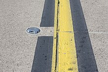
Markings[edit]
There are runway markings and signs on most large runways. Larger runways have a distance remaining sign (black box with white numbers). This sign uses a single number to indicate the remaining distance of the runway in thousands of feet. For example, a 7 will indicate 7,000 ft (2,134 m) remaining. The runway threshold is marked by a line of green lights.
![Runway Identifying numbers being painted at Rocky Mountain Metropolitan Airport [KBJC]](https://upload.wikimedia.org/wikipedia/commons/thumb/0/0a/Runway_Number_Painting.jpg/220px-Runway_Number_Painting.jpg)
There are three types of runways:
- Visual runways are used at small airstrips and are usually just a strip of grass, gravel, ice, asphalt, or concrete. Although there are usually no markings on a visual runway, they may have threshold markings, designators, and centerlines. Additionally, they do not provide an instrument-based landing procedure; pilots must be able to see the runway to use it. Also, radio communication may not be available and pilots must be self-reliant.
- Non-precision instrument runways are often used at small- to medium-size airports. These runways, depending on the surface, may be marked with threshold markings, designators, centerlines, and sometimes a 1,000 ft (305 m) mark (known as an aiming point, sometimes installed at 1,500 ft (457 m)). While centerlines provide horizontal position guidance, aiming point markers provide vertical position guidance to planes on visual approach.
- Precision instrument runways, which are found at medium- and large-size airports, consist of a blast pad/stopway (optional, for airports handling jets), threshold, designator, centerline, aiming point, and 500 ft (152 m), 1,000 ft (305 m)/1,500 ft (457 m), 2,000 ft (610 m), 2,500 ft (762 m), and 3,000 ft (914 m) touchdown zone marks. Precision runways provide both horizontal and vertical guidance for instrument approaches.
Waterways may be unmarked or marked with buoys that follow maritime notation instead.[27]
National variants[edit]
- In Australia, Canada, the United Kingdom,[28] as well as some other countries or territories (Hong Kong and Macau) all 3-stripe and 2-stripe touchdown zones for precision runways are replaced with one-stripe touchdown zones.
- In some South American countries like Colombia, Ecuador and Peru, one 3-stripe is added and a 2-stripe is replaced with the aiming point.
- Some European countries replace the aiming point with a 3-stripe touchdown zone.
- Runways in Norway have yellow markings instead of the usual white ones. This also occurs in some airports in Japan, Sweden, and Finland. The yellow markings are used to ensure better contrast against snow.
- Runways may have different types of equipment on each end. To reduce costs, many airports do not install precision guidance equipment on both ends. Runways with one precision end and any other type of end can install the full set of touchdown zones, even if some are past the midpoint. Runways with precision markings on both ends omit touchdown zones within 900 ft (274 m) of the midpoint, to avoid ambiguity over the end with which the zone is associated.
Lighting[edit]

A runway landing light from 1945
A line of lights on an airfield or elsewhere to guide aircraft in taking off or coming in to land or an illuminated runway is sometimes also known as a flare path.
Technical specifications[edit]
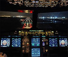
Night runway view from A320 cockpit
Runway lighting are used at airports for use at night and low visibility. Seen from the air, runway lights form an outline of the runway. A runway may have some or all of the following:[29]
- Runway end identifier lights (REIL) – unidirectional (facing approach direction) or omnidirectional pair of synchronized flashing lights installed at the runway threshold, one on each side.
- Runway end lights – a pair of four lights on each side of the runway on precision instrument runways, these lights extend along the full width of the runway. These lights show green when viewed by approaching aircraft and red when seen from the runway.
- Runway edge lights – white elevated lights that run the length of the runway on either side. On precision instrument runways, the edge-lighting becomes amber in the last 2,000 ft (610 m) of the runway, or last third of the runway, whichever is less. Taxiways are differentiated by being bordered by blue lights, or by having green center lights, depending on the width of the taxiway, and the complexity of the taxi pattern.
- Runway centerline lighting system (RCLS) – lights embedded into the surface of the runway at 50 ft (15 m) intervals along the runway centerline on some precision instrument runways. White except the last 900 m (3,000 ft): alternate white and red for next 600 m (1,969 ft) and red for last 300 m (984 ft).[29]
- Touchdown zone lights (TDZL[17]) – rows of white light bars (with three in each row) at 30 or 60 m (98 or 197 ft) intervals on either side of the centerline for 900 m (3,000 ft).[29]
- Taxiway centerline lead-off lights – installed along lead-off markings, alternate green and yellow lights embedded into the runway pavement. It starts with green light at about the runway centerline to the position of first centerline light beyond the Hold-Short markings on the taxiway.
- Taxiway centerline lead-on lights – installed the same way as taxiway centerline lead-off Lights, but directing airplane traffic in the opposite direction.
- Land and hold short lights – a row of white pulsating lights installed across the runway to indicate hold short position on some runways that are facilitating land and hold short operations (LAHSO).[29]
- Approach lighting system (ALS) – a lighting system installed on the approach end of an airport runway and consists of a series of lightbars, strobe lights, or a combination of the two that extends outward from the runway end.
According to Transport Canada’s regulations,[30] the runway-edge lighting must be visible for at least 2 mi (3 km). Additionally, a new system of advisory lighting, runway status lights, is currently being tested in the United States.[31]
The edge lights must be arranged such that:
- the minimum distance between lines is 75 ft (23 m), and maximum is 200 ft (61 m)
- the maximum distance between lights within each line is 200 ft (61 m)
- the minimum length of parallel lines is 1,400 ft (427 m)
- the minimum number of lights in the line is 8.[32]

Control of lighting system[edit]
Typically the lights are controlled by a control tower, a flight service station or another designated authority. Some airports/airfields (particularly uncontrolled ones) are equipped with pilot-controlled lighting, so that pilots can temporarily turn on the lights when the relevant authority is not available.[33] This avoids the need for automatic systems or staff to turn the lights on at night or in other low visibility situations. This also avoids the cost of having the lighting system on for extended periods. Smaller airports may not have lighted runways or runway markings. Particularly at private airfields for light planes, there may be nothing more than a windsock beside a landing strip.
Safety[edit]
Types of runway safety incidents include:
- Runway excursion – an incident involving only a single aircraft, where it makes an inappropriate exit from the runway (e.g. Thai Airways Flight 679).
- Runway overrun (also known as an overshoot) – a type of excursion where the aircraft is unable to stop before the end of the runway (e.g. Air France Flight 358, TAM Airlines Flight 3054, Air India Express Flight 812).
- Runway incursion – an incident involving incorrect presence of a vehicle, person or another aircraft on the runway (e.g. Aeroflot Flight 3352, Scandinavian Airlines Flight 686).
- Runway confusion – an aircraft makes use of the wrong runway for landing or takeoff (e.g. Singapore Airlines Flight 006, Western Airlines Flight 2605).
- Runway undershoot – an aircraft that lands short of the runway (e.g. British Airways Flight 38, Asiana Airlines Flight 214).
Surface[edit]

The choice of material used to construct the runway depends on the use and the local ground conditions. For a major airport, where the ground conditions permit, the most satisfactory type of pavement for long-term minimum maintenance is concrete. Although certain airports have used reinforcement in concrete pavements, this is generally found to be unnecessary, with the exception of expansion joints across the runway where a dowel assembly, which permits relative movement of the concrete slabs, is placed in the concrete. Where it can be anticipated that major settlements of the runway will occur over the years because of unstable ground conditions, it is preferable to install asphaltic concrete surface, as it is easier to patch on a periodic basis. Fields with very low traffic of light planes may use a sod surface. Some runways make use of salt flats.
For pavement designs, borings are taken to determine the subgrade condition, and based on the relative bearing capacity of the subgrade, the specifications are established. For heavy-duty commercial aircraft, the pavement thickness, no matter what the top surface, varies from 10 to 48 in (25 to 122 cm), including subgrade.
Airport pavements have been designed by two methods. The first, Westergaard, is based on the assumption that the pavement is an elastic plate supported on a heavy fluid base with a uniform reaction coefficient known as the K value. Experience has shown that the K values on which the formula was developed are not applicable for newer aircraft with very large footprint pressures.
The second method is called the California bearing ratio and was developed in the late 1940s. It is an extrapolation of the original test results, which are not applicable to modern aircraft pavements or to modern aircraft landing gear. Some designs were made by a mixture of these two design theories. A more recent method is an analytical system based on the introduction of vehicle response as an important design parameter. Essentially it takes into account all factors, including the traffic conditions, service life, materials used in the construction, and, especially important, the dynamic response of the vehicles using the landing area.
Because airport pavement construction is so expensive, manufacturers aim to minimize aircraft stresses on the pavement. Manufacturers of the larger planes design landing gear so that the weight of the plane is supported on larger and more numerous tires. Attention is also paid to the characteristics of the landing gear itself, so that adverse effects on the pavement are minimized. Sometimes it is possible to reinforce a pavement for higher loading by applying an overlay of asphaltic concrete or portland cement concrete that is bonded to the original slab. Post-tensioning concrete has been developed for the runway surface. This permits the use of thinner pavements and should result in longer concrete pavement life. Because of the susceptibility of thinner pavements to frost heave, this process is generally applicable only where there is no appreciable frost action.
Pavement surface[edit]

Runway pavement surface is prepared and maintained to maximize friction for wheel braking. To minimize hydroplaning following heavy rain, the pavement surface is usually grooved so that the surface water film flows into the grooves and the peaks between grooves will still be in contact with the aircraft tires. To maintain the macrotexturing built into the runway by the grooves, maintenance crews engage in airfield rubber removal or hydrocleaning in order to meet required FAA friction levels.
Pavement subsurface drainage and underdrains[edit]
Subsurface underdrains help provide extended life and excellent and reliable pavement performance. At the Hartsfield Atlanta, GA airport the underdrains usually consist of trenches 18 in (46 cm) wide and 48 in (120 cm) deep from the top of the pavement. A perforated plastic tube (5.9 in (15 cm) in diameter) is placed at the bottom of the ditch. The ditches are filled with gravel size crushed stone.[34] Excessive moisture under a concrete pavement can cause pumping, cracking, and joint failure.[35]
Surface type codes[edit]

The grass airstrip on the Badminton estate, Badminton, South Gloucestershire, England. The strip is very simple: no lighting, no centerline, and no approach aids. The edge is marked by simple posts.
In aviation charts, the surface type is usually abbreviated to a three-letter code.
The most common hard surface types are asphalt and concrete. The most common soft surface types are grass and gravel.
| Abbreviation | Meaning |
|---|---|
| ASP | Asphalt |
| BIT | Bituminous asphalt or tarmac |
| BRI | Bricks (no longer in use, covered with asphalt or concrete now) |
| CLA | Clay |
| COM | Composite |
| CON | Concrete |
| COP | Composite |
| COR | Coral (fine crushed coral reef structures) |
| GRE | Graded or rolled earth, grass on graded earth |
| GRS | Grass or earth not graded or rolled |
| GVL | Gravel |
| ICE | Ice |
| LAT | Laterite |
| MAC | Macadam |
| PEM | Partially concrete, asphalt or bitumen-bound macadam |
| PER | Permanent surface, details unknown |
| PSP | Marston Matting (derived from pierced/perforated steel planking) |
| SAN | Sand |
| SMT | Sommerfeld Tracking |
| SNO | Snow |
| U | Unknown surface |
| WAT | Water |
Length[edit]
A runway of at least 1,800 m (5,900 ft) in length is usually adequate for aircraft weights below approximately 100,000 kg (220,000 lb). Larger aircraft including widebodies will usually require at least 2,400 m (7,900 ft) at sea level. International widebody flights, which carry substantial amounts of fuel and are therefore heavier, may also have landing requirements of 3,200 m (10,500 ft) or more and takeoff requirements of 4,000 m (13,000 ft). The Boeing 747 is considered to have the longest takeoff distance of the more common aircraft types and has set the standard for runway lengths of larger international airports.[36]
At sea level, 3,200 m (10,500 ft) can be considered an adequate length to land virtually any aircraft. For example, at O’Hare International Airport, when landing simultaneously on 4L/22R and 10/28 or parallel 9R/27L, it is routine for arrivals from East Asia, which would normally be vectored for 4L/22R (2,300 m (7,546 ft)) or 9R/27L (2,400 m (7,874 ft)) to request 28R (4,000 m (13,123 ft)). It is always accommodated, although occasionally with a delay. Another example is that the Luleå Airport in Sweden was extended to 3,500 m (11,483 ft) to allow any fully loaded freight aircraft to take off.
An aircraft taking off at a higher altitude must do so at reduced weight due to decreased density of air at higher altitudes, which reduces engine power and wing lift. An aircraft must also take off at a reduced weight in hotter or more humid conditions (see density altitude). Most commercial aircraft carry manufacturer’s tables showing the adjustments required for a given temperature.
In India, recommendations of International Civil Aviation Organization (ICAO) are now followed more often. For landing, only altitude correction is done for runway length whereas for take-off, all types of correction are taken into consideration.[37]
The world’s longest paved runway, at Qamdo Bamda Airport in Tibet (China), has a total length of 5,500 m (18,045 ft).
-

-
Road crossing of (Shetland) A970 with Sumburgh Airport’s runway. The movable barrier closes when aircraft land or take off.
See also[edit]
- Engineered materials arrestor system
- Helipad
- Highway strip
- ICAO recommendations on use of the International System of Units
- Instrument landing system (ILS)
- List of airports
- Pavement classification number (PCN)
- Precision approach path indicator
- Roll way, sometimes referred as a runway[38]
- Runway visual range
- Tabletop runway
- Visual approach slope indicator
References[edit]
- ^ International standards and recommended practices. Aerodromes. Annex 14 to the Convention on International Civil Aviation. ICAO. 1951. p. 17.
- ^ Aviation’s Crazy, Mixed Up Units of Measure — AeroSavvy
- ^ Rupa Haria (Jan 10, 2018). «1919: Orville Wright On The Future Of Civil Flying». Aviation Week Network. Archived from the original on April 16, 2019. Retrieved January 10, 2018.
- ^ «Enviroware — Blog». www.enviroware.com. Retrieved 2012-02-24.
- ^ «Airport — when and why was runway 07/25 at Kai Tak removed?».
- ^ Federal Aviation Administration Aeronautical Information Manual, Chapter 2, Section 3 Airport Marking Aids and Signs part 3b Archived 2012-01-18 at the Wayback Machine
- ^ «Chapter 2.3.e.(2)». FAA Advisory Circular AC 150/5340-1L — Standards for Airport Markings. p. 17.
A single-digit runway landing designation number is never preceded by a zero.
- ^ «New assault landing strip opens in Wyoming; McChord C-17 makes first landing».
- ^ «Duke Field (Eglin AF Aux Nr 3) Airport». Airnav.com. July 16, 2020. Retrieved August 5, 2020.
- ^ «Dobbins Air Reserve Base». Airnav.com. July 16, 2020. Retrieved August 5, 2020.
- ^ «Ketchikan Harbor Seaplane Base». Airnav.com. July 16, 2020. Retrieved August 8, 2020.
- ^ a b c FAA AC 150/5200-35
- ^ «Pebbly Beach Seaplane Base». Airnav.com. July 16, 2020. Retrieved August 5, 2020.
- ^ «Daniel K Inouye International Airport». Airnav.com. July 16, 2020. Retrieved August 5, 2020.
- ^ Jeppesen Airport Chart Legend
- ^ Edwards AFB Rogers Lakebed Airport Diagram (PDF), effective 29 Dec 2022. Federal Aviation Administration.
- ^ a b c d e «Order JO 7340.1Z: Contractions» (PDF). Federal Aviation Administration. March 15, 2007.
- ^ a b c d ICAO Annex 14, Aerodrome Design and Operations Vol 1. ICAO. 2016. pp. Chapter 1-Definitions, Chapter 2.8-declared distances, Attachment A section 3. ISBN 978-92-9258-031-5.
- ^ a b c Airplanes: Turbine engine powered: Takeoff limitations, retrieved 2009-10-04
- ^ Airplanes: Turbine engine powered: Landing limitations: Destination airports, retrieved 2009-10-04
- ^ Swatton, Peter J. (2000). Aircraft Performance Theory for Pilots (illustrated, reprint ed.). Oxford, United Kingdom: Blackwell Science Ltd. p. vii. ISBN 0632055693.
- ^ FAA AC 150/5340-1L – Standards for Airport Markings pages 13 and following
- ^ (PDF) http://128.173.204.63/courses/cee4674/cee4674_pub/markings_airports_rev.pdf. Retrieved 2013-07-10. [dead link]
- ^ a b «Archived copy» (PDF). Archived from the original (PDF) on 21 February 2015. Retrieved 20 February 2015.
{{cite web}}: CS1 maint: archived copy as title (link) FAA Advisory Circular 150/5300-13A (PDF) - ^ Pilot’s Handbook of Aeronautical Knowledge FAA-H-8083-25A, p. 306
- ^ US Federal Aviation Regulations, FAR Part 1, Definitions and abbreviations
- ^ FAA-H-8083-23, Seaplane, Skiplane, and Float/Ski Equipped Helicopter Operations Handbook (Chapters 1–3)
- ^ CAP637, Visual aids handbook, chapter 2, page 3, Issue 2, May 2007, Civil Aviation Authority
- ^ a b c d «Aerodrome Design and Operations» (PDF) (3 ed.). July 1999. Archived from the original (PDF) on 2012-07-23.
- ^ «§7.8 Runway Lighting». TP 14371: Transport Canada Aeronautical Information Manual. Archived from the original on 2013-03-22.
- ^ FAA Installs Runway Safety Warning System at LAX, archived from the original on 2011-06-06, retrieved 2010-05-14
- ^ Transport Canada Aeronautical Information Manual Archived 2008-06-17 at the Wayback Machine
- ^ «§7.18 Aircraft Radio Control of Aerodrome Lighting». TP 14371: Transport Canada Aeronautical Information Manual. Archived from the original on 2013-03-22.
- ^ [1] Design, Construction and Maintenance of Concrete Pavements at the | World’s Busiest Airport | W. Charles Greer, Jr., P.E. | AMEC Environment & Infrastructure, Inc., Alpharetta, GA, USA | Subash Reddy Kuchikulla | Materials Managers and Engineers, Inc., Atlanta, GA, USA | Kathryn Masters, P.E. | Hartsfield | Jackson Atlanta International Airport, Atlanta, GA, USA | John Rone, P.E. | Hartsfield | Jackson Atlanta International Airport, Atlanta, GA
- ^ [2] Minnesota | Dept. of Transportation| Pavement Manual | 5-4.02 Subsurface Drainage
- ^ baer, jeff (2020-11-24). «Airport Runways — Requirements and Regulations». Air Planning. Retrieved 2021-11-27.
- ^ «Runway Incursion and Airport Design — SKYbrary Aviation Safety». www.skybrary.aero. Retrieved 2020-01-01.
- ^ Bogie
External links[edit]
![]()
Look up runway in Wiktionary, the free dictionary.
![]()
Wikimedia Commons has media related to Runway.
- World Airport and Runway Map (ICAO official site)
- United States Aeronautical Information Manual – Federal Aviation Administration (published yearly)
- United States Airport/Facility Directory (d-AFD) – Federal Aviation Administration (published every 56 days)
- United States Terminal Procedures Publication/Airport Diagrams (d-TPP) – Federal Aviation Administration (published every 28 days)
- North American Powered Parachute Federation
- Visual Aids Handbook – Civil Aviation Authority
This article is about the aircraft takeoff and landing area. For other uses, see Runway (disambiguation).
«Landing strip» redirects here. For the pubic hairstyle, see Bikini waxing.
Not to be confused with Roll way.
An MD-11 at one end of a runway
According to the International Civil Aviation Organization (ICAO), a runway is a «defined rectangular area on a land aerodrome prepared for the landing and takeoff of aircraft».[1] Runways may be a man-made surface (often asphalt, concrete, or a mixture of both) or a natural surface (grass, dirt, gravel, ice, sand or salt). Runways, as well as taxiways and ramps, are sometimes referred to as «tarmac», though very few runways are built using tarmac. Takeoff and landing areas defined on the surface of water for seaplanes are generally referred to as waterways. Runway lengths are now commonly given in meters worldwide, except in North America where feet are commonly used.[2]
History[edit]
In 1916, in a World War I war effort context, the first concrete-paved runway was built in Clermont-Ferrand in France, allowing local company Michelin to manufacture Bréguet Aviation military aircraft.
In January 1919, aviation pioneer Orville Wright underlined the need for «distinctly marked and carefully prepared landing places, [but] the preparing of the surface of reasonably flat ground [is] an expensive undertaking [and] there would also be a continuous expense for the upkeep.»[3]
Headings[edit]
For fixed-wing aircraft, it is advantageous to perform takeoffs and landings into the wind to reduce takeoff or landing roll and reduce the ground speed needed to attain flying speed. Larger airports usually have several runways in different directions, so that one can be selected that is most nearly aligned with the wind. Airports with one runway are often constructed to be aligned with the prevailing wind. Compiling a wind rose is in fact one of the preliminary steps taken in constructing airport runways.[4] Note that wind direction is given as the direction the wind is coming from: a plane taking off from runway 09 faces east, into an «east wind» blowing from 090°.
Originally in the 1920s and 1930s, airports and air bases (particularly in the United Kingdom) were built in a triangle-like pattern of three runways at 60° angles to each other. The reason was that back then aviation was only starting, and as a result although it was known that winds affect runway distance required, etc. not much was known about wind behaviour. As a result, three runways in a triangle-like pattern were built, and the runway with the heaviest traffic on it would eventually expand into an airport’s main runway, while the other two runways would be either abandoned or converted into taxiways.[5] For example Bristol Airport has only one runway—09/27 (9/27)—and two taxiways that form a ‘V’ which may have been runways on the original 1930s RAF Lulsgate Bottom airbase.[citation needed]
Naming[edit]
Font and size of numbers and letters
Runways are named by a number between 01 and 36, which is generally the magnetic azimuth of the runway’s heading in decadegrees. This heading differs from true north by the local magnetic declination. A runway numbered 09 points east (90°), runway 18 is south (180°), runway 27 points west (270°) and runway 36 points to the north (360° rather than 0°).[6] When taking off from or landing on runway 09, a plane is heading around 90° (east). A runway can normally be used in both directions, and is named for each direction separately: e.g., «runway 15» in one direction is «runway 33» when used in the other. The two numbers differ by 18 (= 180°). For clarity in radio communications, each digit in the runway name is pronounced individually: runway one-five, runway three-three, etc. (instead of «fifteen» or «thirty-three»).
FAA airport diagram at O’Hare International Airport. The two 14/32 runways go from upper left to lower right, the two 4/22 runways go from lower left to upper right, and the two 9/27 and three 10/28 runways are horizontal.
A leading zero, for example in «runway zero-six» or «runway zero-one-left», is included for all ICAO and some U.S. military airports (such as Edwards Air Force Base). However, most U.S. civil aviation airports drop the leading zero as required by FAA regulation.[7] This also includes some military airfields such as Cairns Army Airfield. This American anomaly may lead to inconsistencies in conversations between American pilots and controllers in other countries. It is very common in a country such as Canada for a controller to clear an incoming American aircraft to, for example, runway 04, and the pilot read back the clearance as runway 4. In flight simulation programs those of American origin might apply U.S. usage to airports around the world. For example, runway 05 at Halifax will appear on the program as the single digit 5 rather than 05.
Military airbases may include smaller paved runways known as «assault strips» for practice and training next to larger primary runways.[8] These strips eschew the standard numerical naming convention and instead employ the runway’s full three digit heading; examples include Dobbins Air Reserve Base’s Runway 110/290 and Duke Field’s Runway 180/360.[9][10]
Runways with non-hard surfaces, such as small turf airfields and waterways for seaplanes, may use the standard numerical scheme or may use traditional compass point naming, examples include Ketchikan Harbor Seaplane Base’s Waterway E/W.[11][12] Airports with unpredictable or chaotic water currents, such as Santa Catalina Island’s Pebbly Beach Seaplane Base, may designate their landing area as Waterway ALL/WAY to denote the lack of designated landing direction.[13][12]
Letter suffix[edit]
If there is more than one runway pointing in the same direction (parallel runways), each runway is identified by appending left (L), center (C) and right (R) to the end of the runway number to identify its position (when facing its direction)—for example, runways one-five-left (15L), one-five-center (15C), and one-five-right (15R). Runway zero-three-left (03L) becomes runway two-one-right (21R) when used in the opposite direction (derived from adding 18 to the original number for the 180° difference when approaching from the opposite direction). In some countries, regulations mandate that where parallel runways are too close to each other, only one may be used at a time under certain conditions (usually adverse weather).
At large airports with four or more parallel runways (for example, at Chicago O’Hare, Los Angeles, Detroit Metropolitan Wayne County, Hartsfield-Jackson Atlanta, Denver, Dallas–Fort Worth and Orlando), some runway identifiers are shifted by 1 to avoid the ambiguity that would result with more than three parallel runways. For example, in Los Angeles, this system results in runways 6L, 6R, 7L, and 7R, even though all four runways are actually parallel at approximately 69°. At Dallas/Fort Worth International Airport, there are five parallel runways, named 17L, 17C, 17R, 18L, and 18R, all oriented at a heading of 175.4°. Occasionally, an airport with only three parallel runways may use different runway identifiers, such as when a third parallel runway was opened at Phoenix Sky Harbor International Airport in 2000 to the south of existing 8R/26L—rather than confusingly becoming the «new» 8R/26L it was instead designated 7R/25L, with the former 8R/26L becoming 7L/25R and 8L/26R becoming 8/26.
Suffixes may also be used to denote special use runways. Airports that have seaplane waterways may chose to denote the waterway on charts with the suffix W; such as Daniel K. Inouye International Airport in Honolulu and Lake Hood Seaplane Base in Anchorage.[14] Small airports that host various forms of air traffic may employ additional suffixes to denote special runway types based on the type of aircraft expected to use them, including STOL aircraft (S), gliders (G), rotorcraft (H), and ultralights (U).[12] Runways that are numbered relative to true north rather than magnetic north will use the suffix T; this is advantageous for certain airfields in the far north such as Thule Air Base.[15]
Renumbering[edit]
Runway designations may change over time because Earth’s magnetic lines slowly drift on the surface and the magnetic direction changes. Depending on the airport location and how much drift occurs, it may be necessary to change the runway designation. As runways are designated with headings rounded to the nearest 10°, this affects some runways sooner than others. For example, if the magnetic heading of a runway is 233°, it is designated Runway 23. If the magnetic heading changes downwards by 5 degrees to 228°, the runway remains Runway 23. If on the other hand the original magnetic heading was 226° (Runway 23), and the heading decreased by only 2 degrees to 224°, the runway becomes Runway 22. Because magnetic drift itself is slow, runway designation changes are uncommon, and not welcomed, as they require an accompanying change in aeronautical charts and descriptive documents. When a runway designation does change, especially at major airports, it is often done at night, because taxiway signs need to be changed and the numbers at each end of the runway need to be repainted to the new runway designators. In July 2009 for example, London Stansted Airport in the United Kingdom changed its runway designations from 05/23 to 04/22 during the night.
Declared distances[edit]
Runway dimensions vary from as small as 245 m (804 ft) long and 8 m (26 ft) wide in smaller general aviation airports, to 5,500 m (18,045 ft) long and 80 m (262 ft) wide at large international airports built to accommodate the largest jets, to the huge 11,917 m × 274 m (39,098 ft × 899 ft) lake bed runway 17/35 at Edwards Air Force Base in California – developed as a landing site for the Space Shuttle.[16]
Takeoff and landing distances available are given using one of the following terms:
- Takeoff Run Available (TORA)[17][18] – The length of runway declared available and suitable for the ground run of an airplane taking off.[19]
- Takeoff Distance Available (TODA)[17][18] – The length of the takeoff run available plus the length of the clearway, if clearway is provided.[19] (The clearway length allowed must lie within the aerodrome or airport boundary. According to the Federal Aviation Regulations and Joint Aviation Requirements (JAR) TODA is the lesser of TORA plus clearway or 1.5 times TORA).
- Accelerate-Stop Distance Available (ASDA)[17][18] – The length of the takeoff run available plus the length of the stopway, if stopway is provided.[19]
- Landing Distance Available (LDA)[17][18] – The length of runway that is declared available and suitable for the ground run of an airplane landing.[20]
- Emergency Distance Available (EMDA)[21] – LDA (or TORA) plus a stopway.
Sections[edit]
There are standards for runway markings.[22]
- The runway thresholds are markings across the runway that denote the beginning and end of the designated space for landing and takeoff under non-emergency conditions.[23]
- The runway safety area is the cleared, smoothed and graded area around the paved runway. It is kept free from any obstacles that might impede flight or ground roll of aircraft.
- The runway is the surface from threshold to threshold (including displaced thresholds), which typically features threshold markings, numbers, and centerlines, but excludes blast pads and stopways at both ends.
- Blast pads are often constructed just before the start of a runway where jet blast produced by large planes during the takeoff roll could otherwise erode the ground and eventually damage the runway.
- Stopways, also known as overrun areas, are also constructed at the end of runways as emergency space to stop planes that overrun the runway on landing or a rejected takeoff.
- Blast pads and stopways look similar, and are both marked with yellow chevrons; stopways may optionally be surrounded by red runway lights. The differences are that stopways can support the full weight of an aircraft and are designated for use in an aborted takeoff, while blast pads are often not as strong as the main paved surface of the runway and are not to be used for taxiing, landing, or aborted takeoffs.[24] An engineered materials arrestor system (EMAS) may also be present, which may overlap with the end of the blast pad or stopway and is painted similarly (although an EMAS does not count as part of a stopway).[24]
- Displaced thresholds may be used for taxiing, takeoff, and landing rollout, but not for touchdown. A displaced threshold often exists because of obstacles just before the runway, runway strength, or noise restrictions making the beginning section of runway unsuitable for landings.[25] It is marked with white paint arrows that lead up to the beginning of the landing portion of the runway. As with blast pads, landings on displaced thresholds are not permitted aside from emergency use or exigent circumstance.
- Clearway is an area beyond the paved runway, aligned with the runway centerline and under the control of the airport authorities. This area is not less than 500 ft and there are no protruding obstacles except for threshold lights provided that they aren’t higher than 26 inches. There is a limit on the upslope of the clearway of 1.25%. The length of the clearway may be included in the length of the takeoff distance available.[26] For example, if a paved runway is 2,000 metres (6,600 ft) long and there are 400 metres (1,300 ft) of clearway beyond the end of the runway, the takeoff distance available is 2,400 metres (7,900 ft) long. When the runway is to be used for takeoff of a large airplane, the maximum permissible takeoff weight of the airplane can be based on the takeoff distance available, including clearway. Clearway allows large airplanes to take off at a heavier weight than would be allowed if only the length of the paved runway is taken into account.
Markings[edit]
There are runway markings and signs on most large runways. Larger runways have a distance remaining sign (black box with white numbers). This sign uses a single number to indicate the remaining distance of the runway in thousands of feet. For example, a 7 will indicate 7,000 ft (2,134 m) remaining. The runway threshold is marked by a line of green lights.
There are three types of runways:
- Visual runways are used at small airstrips and are usually just a strip of grass, gravel, ice, asphalt, or concrete. Although there are usually no markings on a visual runway, they may have threshold markings, designators, and centerlines. Additionally, they do not provide an instrument-based landing procedure; pilots must be able to see the runway to use it. Also, radio communication may not be available and pilots must be self-reliant.
- Non-precision instrument runways are often used at small- to medium-size airports. These runways, depending on the surface, may be marked with threshold markings, designators, centerlines, and sometimes a 1,000 ft (305 m) mark (known as an aiming point, sometimes installed at 1,500 ft (457 m)). While centerlines provide horizontal position guidance, aiming point markers provide vertical position guidance to planes on visual approach.
- Precision instrument runways, which are found at medium- and large-size airports, consist of a blast pad/stopway (optional, for airports handling jets), threshold, designator, centerline, aiming point, and 500 ft (152 m), 1,000 ft (305 m)/1,500 ft (457 m), 2,000 ft (610 m), 2,500 ft (762 m), and 3,000 ft (914 m) touchdown zone marks. Precision runways provide both horizontal and vertical guidance for instrument approaches.
Waterways may be unmarked or marked with buoys that follow maritime notation instead.[27]
National variants[edit]
- In Australia, Canada, the United Kingdom,[28] as well as some other countries or territories (Hong Kong and Macau) all 3-stripe and 2-stripe touchdown zones for precision runways are replaced with one-stripe touchdown zones.
- In some South American countries like Colombia, Ecuador and Peru, one 3-stripe is added and a 2-stripe is replaced with the aiming point.
- Some European countries replace the aiming point with a 3-stripe touchdown zone.
- Runways in Norway have yellow markings instead of the usual white ones. This also occurs in some airports in Japan, Sweden, and Finland. The yellow markings are used to ensure better contrast against snow.
- Runways may have different types of equipment on each end. To reduce costs, many airports do not install precision guidance equipment on both ends. Runways with one precision end and any other type of end can install the full set of touchdown zones, even if some are past the midpoint. Runways with precision markings on both ends omit touchdown zones within 900 ft (274 m) of the midpoint, to avoid ambiguity over the end with which the zone is associated.
Lighting[edit]
A runway landing light from 1945
A line of lights on an airfield or elsewhere to guide aircraft in taking off or coming in to land or an illuminated runway is sometimes also known as a flare path.
Technical specifications[edit]
Night runway view from A320 cockpit
Runway lighting are used at airports for use at night and low visibility. Seen from the air, runway lights form an outline of the runway. A runway may have some or all of the following:[29]
- Runway end identifier lights (REIL) – unidirectional (facing approach direction) or omnidirectional pair of synchronized flashing lights installed at the runway threshold, one on each side.
- Runway end lights – a pair of four lights on each side of the runway on precision instrument runways, these lights extend along the full width of the runway. These lights show green when viewed by approaching aircraft and red when seen from the runway.
- Runway edge lights – white elevated lights that run the length of the runway on either side. On precision instrument runways, the edge-lighting becomes amber in the last 2,000 ft (610 m) of the runway, or last third of the runway, whichever is less. Taxiways are differentiated by being bordered by blue lights, or by having green center lights, depending on the width of the taxiway, and the complexity of the taxi pattern.
- Runway centerline lighting system (RCLS) – lights embedded into the surface of the runway at 50 ft (15 m) intervals along the runway centerline on some precision instrument runways. White except the last 900 m (3,000 ft): alternate white and red for next 600 m (1,969 ft) and red for last 300 m (984 ft).[29]
- Touchdown zone lights (TDZL[17]) – rows of white light bars (with three in each row) at 30 or 60 m (98 or 197 ft) intervals on either side of the centerline for 900 m (3,000 ft).[29]
- Taxiway centerline lead-off lights – installed along lead-off markings, alternate green and yellow lights embedded into the runway pavement. It starts with green light at about the runway centerline to the position of first centerline light beyond the Hold-Short markings on the taxiway.
- Taxiway centerline lead-on lights – installed the same way as taxiway centerline lead-off Lights, but directing airplane traffic in the opposite direction.
- Land and hold short lights – a row of white pulsating lights installed across the runway to indicate hold short position on some runways that are facilitating land and hold short operations (LAHSO).[29]
- Approach lighting system (ALS) – a lighting system installed on the approach end of an airport runway and consists of a series of lightbars, strobe lights, or a combination of the two that extends outward from the runway end.
According to Transport Canada’s regulations,[30] the runway-edge lighting must be visible for at least 2 mi (3 km). Additionally, a new system of advisory lighting, runway status lights, is currently being tested in the United States.[31]
The edge lights must be arranged such that:
- the minimum distance between lines is 75 ft (23 m), and maximum is 200 ft (61 m)
- the maximum distance between lights within each line is 200 ft (61 m)
- the minimum length of parallel lines is 1,400 ft (427 m)
- the minimum number of lights in the line is 8.[32]
Control of lighting system[edit]
Typically the lights are controlled by a control tower, a flight service station or another designated authority. Some airports/airfields (particularly uncontrolled ones) are equipped with pilot-controlled lighting, so that pilots can temporarily turn on the lights when the relevant authority is not available.[33] This avoids the need for automatic systems or staff to turn the lights on at night or in other low visibility situations. This also avoids the cost of having the lighting system on for extended periods. Smaller airports may not have lighted runways or runway markings. Particularly at private airfields for light planes, there may be nothing more than a windsock beside a landing strip.
Safety[edit]
Types of runway safety incidents include:
- Runway excursion – an incident involving only a single aircraft, where it makes an inappropriate exit from the runway (e.g. Thai Airways Flight 679).
- Runway overrun (also known as an overshoot) – a type of excursion where the aircraft is unable to stop before the end of the runway (e.g. Air France Flight 358, TAM Airlines Flight 3054, Air India Express Flight 812).
- Runway incursion – an incident involving incorrect presence of a vehicle, person or another aircraft on the runway (e.g. Aeroflot Flight 3352, Scandinavian Airlines Flight 686).
- Runway confusion – an aircraft makes use of the wrong runway for landing or takeoff (e.g. Singapore Airlines Flight 006, Western Airlines Flight 2605).
- Runway undershoot – an aircraft that lands short of the runway (e.g. British Airways Flight 38, Asiana Airlines Flight 214).
Surface[edit]
The choice of material used to construct the runway depends on the use and the local ground conditions. For a major airport, where the ground conditions permit, the most satisfactory type of pavement for long-term minimum maintenance is concrete. Although certain airports have used reinforcement in concrete pavements, this is generally found to be unnecessary, with the exception of expansion joints across the runway where a dowel assembly, which permits relative movement of the concrete slabs, is placed in the concrete. Where it can be anticipated that major settlements of the runway will occur over the years because of unstable ground conditions, it is preferable to install asphaltic concrete surface, as it is easier to patch on a periodic basis. Fields with very low traffic of light planes may use a sod surface. Some runways make use of salt flats.
For pavement designs, borings are taken to determine the subgrade condition, and based on the relative bearing capacity of the subgrade, the specifications are established. For heavy-duty commercial aircraft, the pavement thickness, no matter what the top surface, varies from 10 to 48 in (25 to 122 cm), including subgrade.
Airport pavements have been designed by two methods. The first, Westergaard, is based on the assumption that the pavement is an elastic plate supported on a heavy fluid base with a uniform reaction coefficient known as the K value. Experience has shown that the K values on which the formula was developed are not applicable for newer aircraft with very large footprint pressures.
The second method is called the California bearing ratio and was developed in the late 1940s. It is an extrapolation of the original test results, which are not applicable to modern aircraft pavements or to modern aircraft landing gear. Some designs were made by a mixture of these two design theories. A more recent method is an analytical system based on the introduction of vehicle response as an important design parameter. Essentially it takes into account all factors, including the traffic conditions, service life, materials used in the construction, and, especially important, the dynamic response of the vehicles using the landing area.
Because airport pavement construction is so expensive, manufacturers aim to minimize aircraft stresses on the pavement. Manufacturers of the larger planes design landing gear so that the weight of the plane is supported on larger and more numerous tires. Attention is also paid to the characteristics of the landing gear itself, so that adverse effects on the pavement are minimized. Sometimes it is possible to reinforce a pavement for higher loading by applying an overlay of asphaltic concrete or portland cement concrete that is bonded to the original slab. Post-tensioning concrete has been developed for the runway surface. This permits the use of thinner pavements and should result in longer concrete pavement life. Because of the susceptibility of thinner pavements to frost heave, this process is generally applicable only where there is no appreciable frost action.
Pavement surface[edit]
Runway pavement surface is prepared and maintained to maximize friction for wheel braking. To minimize hydroplaning following heavy rain, the pavement surface is usually grooved so that the surface water film flows into the grooves and the peaks between grooves will still be in contact with the aircraft tires. To maintain the macrotexturing built into the runway by the grooves, maintenance crews engage in airfield rubber removal or hydrocleaning in order to meet required FAA friction levels.
Pavement subsurface drainage and underdrains[edit]
Subsurface underdrains help provide extended life and excellent and reliable pavement performance. At the Hartsfield Atlanta, GA airport the underdrains usually consist of trenches 18 in (46 cm) wide and 48 in (120 cm) deep from the top of the pavement. A perforated plastic tube (5.9 in (15 cm) in diameter) is placed at the bottom of the ditch. The ditches are filled with gravel size crushed stone.[34] Excessive moisture under a concrete pavement can cause pumping, cracking, and joint failure.[35]
Surface type codes[edit]
The grass airstrip on the Badminton estate, Badminton, South Gloucestershire, England. The strip is very simple: no lighting, no centerline, and no approach aids. The edge is marked by simple posts.
In aviation charts, the surface type is usually abbreviated to a three-letter code.
The most common hard surface types are asphalt and concrete. The most common soft surface types are grass and gravel.
| Abbreviation | Meaning |
|---|---|
| ASP | Asphalt |
| BIT | Bituminous asphalt or tarmac |
| BRI | Bricks (no longer in use, covered with asphalt or concrete now) |
| CLA | Clay |
| COM | Composite |
| CON | Concrete |
| COP | Composite |
| COR | Coral (fine crushed coral reef structures) |
| GRE | Graded or rolled earth, grass on graded earth |
| GRS | Grass or earth not graded or rolled |
| GVL | Gravel |
| ICE | Ice |
| LAT | Laterite |
| MAC | Macadam |
| PEM | Partially concrete, asphalt or bitumen-bound macadam |
| PER | Permanent surface, details unknown |
| PSP | Marston Matting (derived from pierced/perforated steel planking) |
| SAN | Sand |
| SMT | Sommerfeld Tracking |
| SNO | Snow |
| U | Unknown surface |
| WAT | Water |
Length[edit]
A runway of at least 1,800 m (5,900 ft) in length is usually adequate for aircraft weights below approximately 100,000 kg (220,000 lb). Larger aircraft including widebodies will usually require at least 2,400 m (7,900 ft) at sea level. International widebody flights, which carry substantial amounts of fuel and are therefore heavier, may also have landing requirements of 3,200 m (10,500 ft) or more and takeoff requirements of 4,000 m (13,000 ft). The Boeing 747 is considered to have the longest takeoff distance of the more common aircraft types and has set the standard for runway lengths of larger international airports.[36]
At sea level, 3,200 m (10,500 ft) can be considered an adequate length to land virtually any aircraft. For example, at O’Hare International Airport, when landing simultaneously on 4L/22R and 10/28 or parallel 9R/27L, it is routine for arrivals from East Asia, which would normally be vectored for 4L/22R (2,300 m (7,546 ft)) or 9R/27L (2,400 m (7,874 ft)) to request 28R (4,000 m (13,123 ft)). It is always accommodated, although occasionally with a delay. Another example is that the Luleå Airport in Sweden was extended to 3,500 m (11,483 ft) to allow any fully loaded freight aircraft to take off.
An aircraft taking off at a higher altitude must do so at reduced weight due to decreased density of air at higher altitudes, which reduces engine power and wing lift. An aircraft must also take off at a reduced weight in hotter or more humid conditions (see density altitude). Most commercial aircraft carry manufacturer’s tables showing the adjustments required for a given temperature.
In India, recommendations of International Civil Aviation Organization (ICAO) are now followed more often. For landing, only altitude correction is done for runway length whereas for take-off, all types of correction are taken into consideration.[37]
The world’s longest paved runway, at Qamdo Bamda Airport in Tibet (China), has a total length of 5,500 m (18,045 ft).
-
-
Road crossing of (Shetland) A970 with Sumburgh Airport’s runway. The movable barrier closes when aircraft land or take off.
See also[edit]
- Engineered materials arrestor system
- Helipad
- Highway strip
- ICAO recommendations on use of the International System of Units
- Instrument landing system (ILS)
- List of airports
- Pavement classification number (PCN)
- Precision approach path indicator
- Roll way, sometimes referred as a runway[38]
- Runway visual range
- Tabletop runway
- Visual approach slope indicator
References[edit]
- ^ International standards and recommended practices. Aerodromes. Annex 14 to the Convention on International Civil Aviation. ICAO. 1951. p. 17.
- ^ Aviation’s Crazy, Mixed Up Units of Measure — AeroSavvy
- ^ Rupa Haria (Jan 10, 2018). «1919: Orville Wright On The Future Of Civil Flying». Aviation Week Network. Archived from the original on April 16, 2019. Retrieved January 10, 2018.
- ^ «Enviroware — Blog». www.enviroware.com. Retrieved 2012-02-24.
- ^ «Airport — when and why was runway 07/25 at Kai Tak removed?».
- ^ Federal Aviation Administration Aeronautical Information Manual, Chapter 2, Section 3 Airport Marking Aids and Signs part 3b Archived 2012-01-18 at the Wayback Machine
- ^ «Chapter 2.3.e.(2)». FAA Advisory Circular AC 150/5340-1L — Standards for Airport Markings. p. 17.
A single-digit runway landing designation number is never preceded by a zero.
- ^ «New assault landing strip opens in Wyoming; McChord C-17 makes first landing».
- ^ «Duke Field (Eglin AF Aux Nr 3) Airport». Airnav.com. July 16, 2020. Retrieved August 5, 2020.
- ^ «Dobbins Air Reserve Base». Airnav.com. July 16, 2020. Retrieved August 5, 2020.
- ^ «Ketchikan Harbor Seaplane Base». Airnav.com. July 16, 2020. Retrieved August 8, 2020.
- ^ a b c FAA AC 150/5200-35
- ^ «Pebbly Beach Seaplane Base». Airnav.com. July 16, 2020. Retrieved August 5, 2020.
- ^ «Daniel K Inouye International Airport». Airnav.com. July 16, 2020. Retrieved August 5, 2020.
- ^ Jeppesen Airport Chart Legend
- ^ Edwards AFB Rogers Lakebed Airport Diagram (PDF), effective 29 Dec 2022. Federal Aviation Administration.
- ^ a b c d e «Order JO 7340.1Z: Contractions» (PDF). Federal Aviation Administration. March 15, 2007.
- ^ a b c d ICAO Annex 14, Aerodrome Design and Operations Vol 1. ICAO. 2016. pp. Chapter 1-Definitions, Chapter 2.8-declared distances, Attachment A section 3. ISBN 978-92-9258-031-5.
- ^ a b c Airplanes: Turbine engine powered: Takeoff limitations, retrieved 2009-10-04
- ^ Airplanes: Turbine engine powered: Landing limitations: Destination airports, retrieved 2009-10-04
- ^ Swatton, Peter J. (2000). Aircraft Performance Theory for Pilots (illustrated, reprint ed.). Oxford, United Kingdom: Blackwell Science Ltd. p. vii. ISBN 0632055693.
- ^ FAA AC 150/5340-1L – Standards for Airport Markings pages 13 and following
- ^ (PDF) http://128.173.204.63/courses/cee4674/cee4674_pub/markings_airports_rev.pdf. Retrieved 2013-07-10. [dead link]
- ^ a b «Archived copy» (PDF). Archived from the original (PDF) on 21 February 2015. Retrieved 20 February 2015.
{{cite web}}: CS1 maint: archived copy as title (link) FAA Advisory Circular 150/5300-13A (PDF) - ^ Pilot’s Handbook of Aeronautical Knowledge FAA-H-8083-25A, p. 306
- ^ US Federal Aviation Regulations, FAR Part 1, Definitions and abbreviations
- ^ FAA-H-8083-23, Seaplane, Skiplane, and Float/Ski Equipped Helicopter Operations Handbook (Chapters 1–3)
- ^ CAP637, Visual aids handbook, chapter 2, page 3, Issue 2, May 2007, Civil Aviation Authority
- ^ a b c d «Aerodrome Design and Operations» (PDF) (3 ed.). July 1999. Archived from the original (PDF) on 2012-07-23.
- ^ «§7.8 Runway Lighting». TP 14371: Transport Canada Aeronautical Information Manual. Archived from the original on 2013-03-22.
- ^ FAA Installs Runway Safety Warning System at LAX, archived from the original on 2011-06-06, retrieved 2010-05-14
- ^ Transport Canada Aeronautical Information Manual Archived 2008-06-17 at the Wayback Machine
- ^ «§7.18 Aircraft Radio Control of Aerodrome Lighting». TP 14371: Transport Canada Aeronautical Information Manual. Archived from the original on 2013-03-22.
- ^ [1] Design, Construction and Maintenance of Concrete Pavements at the | World’s Busiest Airport | W. Charles Greer, Jr., P.E. | AMEC Environment & Infrastructure, Inc., Alpharetta, GA, USA | Subash Reddy Kuchikulla | Materials Managers and Engineers, Inc., Atlanta, GA, USA | Kathryn Masters, P.E. | Hartsfield | Jackson Atlanta International Airport, Atlanta, GA, USA | John Rone, P.E. | Hartsfield | Jackson Atlanta International Airport, Atlanta, GA
- ^ [2] Minnesota | Dept. of Transportation| Pavement Manual | 5-4.02 Subsurface Drainage
- ^ baer, jeff (2020-11-24). «Airport Runways — Requirements and Regulations». Air Planning. Retrieved 2021-11-27.
- ^ «Runway Incursion and Airport Design — SKYbrary Aviation Safety». www.skybrary.aero. Retrieved 2020-01-01.
- ^ Bogie
External links[edit]
![]()
Look up runway in Wiktionary, the free dictionary.
![]()
Wikimedia Commons has media related to Runway.
- World Airport and Runway Map (ICAO official site)
- United States Aeronautical Information Manual – Federal Aviation Administration (published yearly)
- United States Airport/Facility Directory (d-AFD) – Federal Aviation Administration (published every 56 days)
- United States Terminal Procedures Publication/Airport Diagrams (d-TPP) – Federal Aviation Administration (published every 28 days)
- North American Powered Parachute Federation
- Visual Aids Handbook – Civil Aviation Authority
Смотреть что такое ВЗЛЁТНОПОСАДОЧНЫЙ в других словарях:
ВЗЛЁТНОПОСАДОЧНЫЙ
взлётно-посадочный
прил., кол-во синонимов: 1
• взлетно-посадочный (2)
Словарь синонимов ASIS.В.Н. Тришин.2013.
.
ВЗЛЁТНОПОСАДОЧНЫЙ
1) Орфографическая запись слова: взлётно-посадочный2) Ударение в слове: взлётно-пос`адочный3) Деление слова на слоги (перенос слова): взлётно—посадочн… смотреть
ВЗЛЁТНОПОСАДОЧНЫЙ
Ударение в слове: взлётно-пос`адочныйУдарение падает на букву: аБезударные гласные в слове: взлётно-пос`адочный
ВЗЛЁТНОПОСАДОЧНЫЙ
ВЗЛЁТНО-ПОСАДОЧНЫЙ, -ая, -ое. Предназначенный для взлёта и посадки летательных аппаратов. Взлётно -посадочная полоса.
взлетно-посадочная полоса
- взлетно-посадочная полоса
-
часть ЛП, специально подготовленная и оборудованная для взлета и посадки воздушных судов. ВПП может иметь искусственное покрытие (ИВПП) или грунтовое (ГВПП). (Смотри:
СНиП 32-03-96. Аэродромы)Источник: «Дом: Строительная терминология», М.: Бук-пресс, 2006.
Строительный словарь.
Смотреть что такое «взлетно-посадочная полоса» в других словарях:
-
взлетно-посадочная полоса — ВПП Часть аэродрома, предназначенная для разбега при взлете и пробега после посадки воздушных судов. [ФАП от 31 марта 2002] Тематики авиационные правила Синонимы ВПП … Справочник технического переводчика
-
Взлетно-посадочная полоса — 2) взлетно посадочная полоса (далее ВПП) определенный прямоугольный участок сухопутного аэродрома, подготовленный для посадки и взлета воздушных судов;… Источник: Приказ Минпромторга РФ от 30.12.2009 N 1215 Об утверждении нормативных… … Официальная терминология
-
Взлетно-посадочная полоса (ВПП) — часть ЛП, специально подготовленная и оборудованная для взлета и посадки воздушных судов. ВПП может иметь искусственное покрытие (ИВПП) или грунтовое (ГВПП). Источник: СНиП 32 03 96: Аэродромы 3.4 взлетно посадочная полоса (ВПП): Часть ЛП,… … Словарь-справочник терминов нормативно-технической документации
-
Взлетно-посадочная полоса необорудованная — 11) необорудованная взлетно посадочная полоса ВПП, предназначенная для воздушных судов, выполняющих визуальный заход на посадку;… Источник: Приказ Минпромторга РФ от 30.12.2009 N 1215 Об утверждении нормативных методических документов,… … Официальная терминология
-
Взлетно-посадочная полоса оборудованная — 12) оборудованная взлетно посадочная полоса один из следующих типов ВПП, предназначенных для воздушных судов, выполняющих заход на посадку по приборам: а) ВПП, оборудованная для неточного захода на посадку ВПП, оборудованная визуальными… … Официальная терминология
-
Взлетно-посадочная полоса (далее — ВПП) — 6. Взлетно посадочная полоса (далее ВПП) основная часть летной полосы аэродрома, специально подготовленная и оборудованная для обеспечения разбега при взлете и пробега после посадки воздушного судна. ВПП может быть с искусственным аэродромным… … Словарь-справочник терминов нормативно-технической документации
-
Взлетно-посадочная полоса — ВПП 31 аэропорта Рузыне, Прага Взлётно посадочная полоса (ВПП) часть аэродрома, входящая в качестве рабочей площади в состав лётной полосы. ВПП представляет собой специально подготовленную и оборудованную полосу земной поверхности с искуственным… … Википедия
-
предпочтительная по шуму взлетно-посадочная полоса — предпочтительная по шуму ВПП Взлетно посадочная полоса многополосового аэродрома, при использовании которой шумовое воздействие на население, проживающее вблизи данного аэропорта, минимально. [ГОСТ 26120 84] Тематики акустика авиационная… … Справочник технического переводчика
-
лунная взлетно-посадочная полоса — Сфотографированные советской автоматической станцией Луна 9 4 и 5 февраля 1966 г. на Луне в Океане Бурь 11 камней, которые образуют определённые геометрические фигуры. E. Moon runway D. Mond Landebahn … Толковый уфологический словарь с эквивалентами на английском и немецком языках
-
Взлетно-посадочная полоса — (ВПП) специально подготовленный и оборудованный участок на аэродроме, позволяющий производить на нем взлет и посадку самолетов. В зависимости от характера оборудованное™ ВПП может быть с естественным и искусственным покрытием. К… … Краткий словарь оперативно-тактических и общевоенных терминов