Отображение широты и долготы в EXCEL
history 25 апреля 2013 г.
- Группы статей
- Пользовательский формат
- Преобразование в ТЕКСТ
- Спецсимволы
Если Вам нужно отобразить широту или долготу в формате 56°54’31″ (56 градусов 54 минуты 31 секунда), то этот пример для Вас.
В зависимости от желаемого результата и исходных данных существуют разные способы отображения широты и долготы в формате 56°54’31″ (56 градусов 54 минуты 31 секунда).
Применение пользовательского формата
Если в ячейке содержится число вида 565431, то применение пользовательского формата позволит только правильно отобразить формат широты и долготы (56°54’31″), арифметические же операции с долготой или шириной произвести не удастся (при прибавлении 30 секунд будем иметь 56°54’61″, а не 56°55’01″). Тем не менее, применим пользовательский формат.
Пользовательский формат вводим через диалоговое окно Формат ячеек . Для вызова окна нажмите CTRL + 1 . Выберите ( все форматы ), удалите все из поля Тип .
- в поле Тип введите ###;
- затем введите туда же знак градуса (°), скопировав из Буфера обмена, в который его заранее туда вставили командой Символ ( Вставка/ Текст/ Символ) . Или удерживая ALT , наберите на цифровой клавиатуре 0176 и отпустите ALT (Подробнее о вводе нестандартных символов читайте в статье Ввод символов с помощью клавиши ALT );
- введите пробел, два нуля, апостроф (‘) и еще пробел;
- введите еще два нуля и еще 2 апострофа (‘) (двойная кавычка не подойдет или ее придется вводить вместе с обратным слешем «);
- нажмите ОК.
Теперь введите в ячейку 565431 и нажмите ENTER , в ячейке отобразится 56°54’31″.
Преобразование из десятичного формата
Часто долготу и широту представляют в десятичном формате. Например, число 122,44 соответствует 122 градусам 26 минутам и 24 секундам. Проверить это не составляет труда: целая часть соответствует градусам, 1 градус соответствует единице, минута– 1/60 градуса, секунда – 1/60 минуты или 1/3600 градуса. Получаем: 122+26*(1/60)+24*(1/3600)=122,44.
С десятичным представлением можно производить необходимые вычисления, например, можно прибавить 2 минуты и 10 секунд: +2*(1/60)+10*(1/3600).
Представить 122,44 в формате долготы и широты с помощью простого форматирования не удастся, нужно использовать формулу для преобразования из десятичного формата. Если значение долготы 122,44 находится в ячейке А1 , то для преобразования в нужный формат запишем формулу: =ТЕКСТ(ОТБР(A1);»0″&СИМВОЛ(176)) &ТЕКСТ(ЦЕЛОЕ(ОСТАТ(A1;1)*60);»0’») &ТЕКСТ(60*ОСТАТ((ОСТАТ(A1;1)*60);1);»0′ «)
Результат: 122°26’24» – значение в текстовом формате.
Как записать широту и долготу
В создании этой статьи участвовала наша опытная команда редакторов и исследователей, которые проверили ее на точность и полноту.
Команда контент-менеджеров wikiHow тщательно следит за работой редакторов, чтобы гарантировать соответствие каждой статьи нашим высоким стандартам качества.
Количество просмотров этой статьи: 31 190.
Широта и долгота — координаты на земном шаре, которые помогут вам найти определенное место. При написании широты и долготы стоит убедиться, что вы используете правильный формат и правильные символы, чтобы вас поняли. Можно определить положение различных точек широты и долготы на карте, а затем записать их. Можно записать широту и долготу, используя только значение параллели и меридиана. Для конкретных точек широты и долготы можно записать координаты с помощью градусов, минут, секунд и десятичных дробей.
Как поставить символ (знак) градуса
Знак градуса (°) — символ, используемый для обозначения размера температуры и угла.
Значок градуса ставится сразу после числового обозначения величины угла или температуры без всякого пробела. Если за ним стоит сокращённое обозначение шкалы (имеется ввиду такие как: C — Цельсий, K — Кельвин, F — Фаренгейт), то эти сокращения отбиваются от знака градуса на 2 типографских пункта. Также следует помнить, что цифру со знаком градуса и температурной шкалой следует набирать со знаком + или —, а не без него.
Градус °
На клавиатуре клавиши с градусом нет, поэтому для его написания применяются различные методы, в том числе:
- символы в Word,
- таблица символов,
- сочетания клавиш на клавиатуре,
- градус на Mac OS,
- градус на iPhone и iPad,
- вёрстка °
Градус в Word
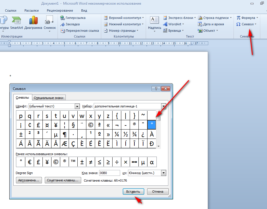
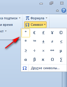
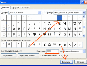
При работе в ворде устанавливаем курсор в нужное место → вкладка Вставка → Символ → Другие символы… (если знака градуса нет в готовом наборе) → Набор: дополнительная латиница-1. Выделяем символ градуса → Вставить.
Программа запомнит ваш выбор. В следующий раз достаточно будет открыть набор ранее использованных символов.
Таблица символов
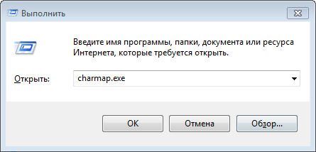
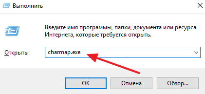
Коллекция символов есть не только в ворде. В Windows существует своя таблица с символами — программа charmap.exe. Для её вызова нажимаем Пуск → Выполнить → charmap.exe → ОК.
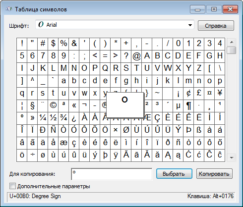
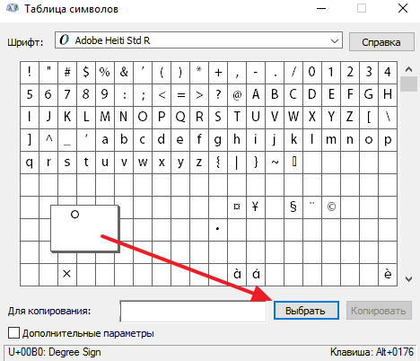
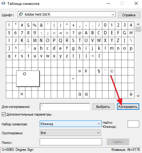
В окне таблицы найдите значок градуса. Выделите его, нажмите кнопку Выбрать и Копировать.
Остаётся лишь вставить символ в нужное место сочетанием клавиш Ctrl и V .
Сочетания клавиш на клавиатуре
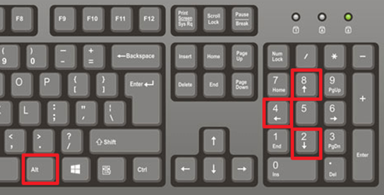
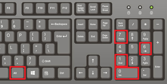
Для написания символа градуса в Windows следует одной рукой нажать клавишу Alt и, удерживая её, другой рукой ввести на клавиатуре цифры 0 1 7 6 .
Отпустите Alt — получится знак градуса цельсия.
Для ноутбуков, у которых на клавиатуре нет цифрового блока, нужно дополнительно нажать клавишу Fn и использовать функциональные клавиши с цифрами.
Mac OS
На компьютерах Mac OS знак градуса можно вставить, нажав клавиши ⌥ + 0 .
Знак градуса на iPhone и iPad
Нажмите и удерживайте клавишу с цифрой 0 — появится дополнительный символ ° .
Download Article
A guide to writing longitude & latitude in different formats, complete with examples
Download Article
- Writing Basic Latitude and Longitude
- Using Degrees, Minutes, and Seconds
- Using Degrees and Decimal Minutes
- Using Decimal Degrees
- Q&A
|
|
|
|
If you’ve ever read a map or a globe, you’re probably familiar with latitude and longitude. These coordinates can you help you pinpoint your exact location on Earth—but how do you write them? There are a few different methods for this, and with a little practice, they’re all easy to learn. This guide will teach you the four most common ways to write latitude and longitude. We’ve also thrown in some tips to help you understand how these coordinates work, plus instructions for finding latitude and longitude using globes, paper maps, and even modern software like Google Maps.
Things You Should Know
- Latitude and Longitude are written as two numbers. The numbers can be written in degrees, minutes, and seconds, (plus N, S, E, W), or in decimals degrees.
- Latitude indicates how far North or South a point is from the equator, while longitude indicates how far East or West a point is from the Prime Meridian.
- Each degree divides into 60 minutes, and each minute divides into 60 seconds. For example, 40°45’11″N is “40 degrees, 45 minutes, and 11 seconds North.”
- For example, New York City’s coordinates in degrees, minutes, & seconds are 40°45’11″N, 73°58’59″W—or 40.753056, -73.983056 in decimal degrees.
-
1
Identify lines of latitude. Lines of latitude run East to West, starting with the 0° line—a.k.a., the equator. Each line is labeled in degrees, followed by “N” for “North” or “S” for “South.” Lines to the North of the equator 0° will be labeled with an “N,” while lines to the South of the equator will have an “S.” The number of degrees increases as you move farther North or South of the equator.[1]
- For example, New York City is located close to latitude line 40°N. This means that New York City is 40 degrees North of the equator.
- Sydney, Australia, is located near the latitude line 34°S. This means that Sydney is 34 degrees South of the 0° equator.[2]
- Latitude lines range from 0°-180° North or South. Since 0° (the equator) sits exactly between the Northern and Southern hemispheres, 0°N and 0°S mean the same thing.
- 180°N is the geographic North Pole, while 180°S is the geographic South Pole. Since these are different locations, 180°N and 180°S are not the same.
-
2
Identify lines of longitude. The lines run North to South, beginning with the 0° longitude line located near London, U.K. Each line is labeled in degrees, followed by an “E” for “East” or a “W” for “West.” Lines to the East of 0° will be labeled with an “E,” while lines to the west of 0°will have a “W.” The number of degrees increases as you move farther East or West of 0°.[3]
- For example, New York City is located close to the longitude line 74°W. This means that New York City is 74 degrees west of the 0° longitude mark.
- Sydney, Australia, is located near the longitude line 150°E. This means that Sydney is 150 degrees east of the 0° longitude mark.
- The 0° longitude mark is called the prime meridian. Since it’s located exactly in between the Eastern and Western hemispheres, 0°E and 0°W mean the same thing.[4]
- The opposite line, 180°, runs North to South in the middle of the Pacific Ocean. As with 0°, 180°E and 180°W mean the same thing since the 180° line is located exactly between the Western and Eastern hemispheres.
Advertisement
-
3
Write the latitude and longitude coordinates of a specific location. The coordinates are always written with latitude first, followed by a comma, followed by longitude. For example, the latitude and longitude of New York City are roughly 40°N, 74°W. For Sydney, the coordinates are roughly 34°S, 150°E.[5]
- Your latitude and longitude won’t be exact when using a map or globe. For example, your map or globe may only show degrees in increments of 5° (that is, 40°, 45°, etc.). Use Google Maps to obtain more precise coordinates.
- For this exercise, you can use the latitude or longitude line nearest to the location you’re measuring. So for New York City, your coordinates might be 40°N, 75°W.
Advertisement
-
1
Use Google Maps to find the latitude and longitude of a specific location. Choose a specific city or location, then tap or right-click to read the latitude and longitude. Your coordinates will have decimal numbers after them. These will get converted to “minutes” and “seconds,” which are fractional portions of a degree.[6]
- On Google maps, your latitude and longitude will be displayed as positive or negative numbers, but no compass direction (that is, no N, S, E, or W). A positive latitude is East, while a negative latitude is West. A positive longitude is North, while a negative longitude is South.
- For example, New York City’s coordinates on Google Maps are roughly 40.753, -73.983. This means 40.753°N, 73.983°W.[7]
-
2
Multiply decimal parts of your degrees by 60 to convert them to minutes. Each degree is divided into 60 minutes, or 1/60 of a degree. Multiplying the decimal parts of your latitude and longitude by 60 gives you the number of minutes represented by the decimal. The minutes are written with an apostrophe. For example, 8 minutes would be written as 8′.[8]
- Let’s use New York City’s coordinates as an example: 40.753°N, 73.983°W. For latitude, the decimal part is .753. For longitude, the decimal part is .983.
- .753 x 60 = 45.18 minutes, written 45.18′.
- .983 x 60 = 58.98 minutes, written 58.98′
-
3
Multiply decimal parts of the minutes by 60 to convert them to seconds. Each minute can be further divided into 60 seconds, or 1/60 of a minute. Multiplying the decimal parts of the minutes by 60 gives you the number of seconds represented by the decimal. The seconds are written with two apostrophes. For example, 17 seconds would be written as 17″.[9]
- Let’s use New York City’s coordinates with minutes as an example: 40° and 45.18′ North for latitude, and 73° and 58.98′ West for longitude. For latitude, the decimal part of the minutes is .18. For longitude, the decimal part of the minutes is .98.
- .18 x 60 = 10.8, or roughly 11 seconds. This is written as 11″.
- .98 x 60 = 58.8, or roughly 59 seconds. This is written as 59″.
-
4
Write your latitude and longitude degrees, minutes, and seconds. After finding the precise coordinates in minutes and seconds for a specific location, write them out in the correct order. Start with your line of latitude, writing the degrees, minutes, and seconds. Add an N (for North) or S (for South) as the direction. Then, write a comma followed by your line of longitude in degrees, minutes, and seconds, adding an E (for East) or W (for West) as the direction.[10]
- For New York City, the latitude is 40 degrees, 45 minutes, and 11 seconds North. The longitude is 73 degrees, 58 minutes, and 59 seconds West.
- Therefore the latitude and longitude of New York City are written as 40°45’11″N, 73°58’59″W.
Advertisement
-
1
Use Google Maps to obtain the latitude and longitude. Pick a city or specific location, then tap or right-click to view the latitude and longitude. The coordinates will have decimal numbers after them. You’ll convert these decimals to “minutes,” which are fractions of a degree.[11]
- On Google maps, latitude and longitude are displayed with positive or negative numbers. They won’t have a compass direction (that is, they won’t have N, S, E, or W). A positive latitude is East, while a negative latitude is West. A positive longitude is North, while a negative longitude is South.
- For example, Sydney, Australia’s coordinates on Google Maps are roughly -33.868, 151.214. This means 33.868°S, 151.214°E.
-
2
Multiply decimal parts of the degrees by 60 to convert to minutes. Each degree on a map is divided into 60 minutes, or 1/60 of a degree. To calculate the number of minutes represented by the decimal parts of your latitude and longitude, multiply the decimal parts by 60. The minutes are written with an apostrophe. For example, 37.44 minutes would be written as 37.44′.[12]
- Let’s use Sydney, Australia’s coordinates as an example: 33.868°S, 151.214°E. For latitude, the decimal part is .868. For longitude, the decimal part is .214.
- .868 x 60 = 52.08 minutes, written 52.08′.
- .214 x 60 = 12.84 minutes, written 12.84′.
-
3
Write your latitude and longitude in degrees and minutes. After finding the precise coordinates in degrees and minutes for a specific location, write them out in the correct order. Start with your line of latitude, writing the degrees and minutes. Add North or South as the direction. Then, write a comma followed by your line of longitude in degrees and minutes, followed by East or West for the direction.[13]
- For Sydney, Australia, the latitude is 33 degrees and 52.08 South. The longitude is 151 degrees and 12.84 minutes East.
- Therefore the latitude and longitude of Sydney, Australia in decimal minutes are 33°52.08’S, 151°12.84’E.
Advertisement
-
1
Use Google Maps to find the latitude and longitude of a specific location. Choose a specific city or location, then tap or right-click to view the latitude and longitude. Your coordinates will be displayed in decimal minutes, without N, S, E, or W.[14]
- For example, your coordinates could be 15.23456 and 30.67890.
-
2
Identify whether numbers are positive or negative. Rather than using North, South, East, and West, positive or negative numbers are used. For lines of latitude, lines North of the equator are positive while lines South of the equator are negative. For lines of longitude, lines East of the Prime Meridian are positive while lines West of the Prime Meridian are negative.[15]
- For example, the line of latitude 15.23456 is north of the equator, while the line -15.23456 is south of the equator.
- The line of longitude written as 30.67890 is east of the Prime Meridian, while the line -30.67890 is west of the Prime Meridian.
-
3
Write latitude and longitude, including decimals. For decimal degrees, simply write out the line of latitude, including decimals, followed by the line of longitude, including decimals. Use positive or negative numbers to indicate direction.[16]
- For example, if your coordinates are 15.23456 degrees north and 30.67890 degrees West, you would write them as «15.23456, -30.67890.»
- For decimal degrees, you do not need to write the degree symbol.
Advertisement
Add New Question
-
Question
Are the digits to the right of the decimal point minutes and seconds respectively?
Usually if you see format 12.345678°, this is not minutes and seconds, but decimal degrees.
Ask a Question
200 characters left
Include your email address to get a message when this question is answered.
Submit
Advertisement
Thanks for submitting a tip for review!
References
About This Article
Article SummaryX
If you want to write latitude and longitude, first, identify the line of latitude on which a location sits. To find the latitude, look at the horizontal lines running north to south from the equator. Count the lines from the equator to the location and write down that number in degrees along with “N” or “S” depending on whether the location is north or south of the equator. Then, identify the line of longitude. Lines of longitude run vertically and stretch from east to west, so count each line between the location and the Prime Meridian to get its degrees. When you have that number, write it down in degrees and denote whether it lies east or west of the Prime Meridian. For example, a set of coordinates could look like “15 degrees N, 30 degrees E”. For more help, like how to write latitude and longitude using degrees, minutes, and seconds, scroll down.
Did this summary help you?
Thanks to all authors for creating a page that has been read 581,421 times.
Reader Success Stories
-
Mubarak Husain
Sep 30, 2020
«It fully covered the basics of the information on latitude and longitude. Further, I will love to find out latitude…» more
Did this article help you?
Download Article
A guide to writing longitude & latitude in different formats, complete with examples
Download Article
- Writing Basic Latitude and Longitude
- Using Degrees, Minutes, and Seconds
- Using Degrees and Decimal Minutes
- Using Decimal Degrees
- Q&A
|
|
|
|
If you’ve ever read a map or a globe, you’re probably familiar with latitude and longitude. These coordinates can you help you pinpoint your exact location on Earth—but how do you write them? There are a few different methods for this, and with a little practice, they’re all easy to learn. This guide will teach you the four most common ways to write latitude and longitude. We’ve also thrown in some tips to help you understand how these coordinates work, plus instructions for finding latitude and longitude using globes, paper maps, and even modern software like Google Maps.
Things You Should Know
- Latitude and Longitude are written as two numbers. The numbers can be written in degrees, minutes, and seconds, (plus N, S, E, W), or in decimals degrees.
- Latitude indicates how far North or South a point is from the equator, while longitude indicates how far East or West a point is from the Prime Meridian.
- Each degree divides into 60 minutes, and each minute divides into 60 seconds. For example, 40°45’11″N is “40 degrees, 45 minutes, and 11 seconds North.”
- For example, New York City’s coordinates in degrees, minutes, & seconds are 40°45’11″N, 73°58’59″W—or 40.753056, -73.983056 in decimal degrees.
-
1
Identify lines of latitude. Lines of latitude run East to West, starting with the 0° line—a.k.a., the equator. Each line is labeled in degrees, followed by “N” for “North” or “S” for “South.” Lines to the North of the equator 0° will be labeled with an “N,” while lines to the South of the equator will have an “S.” The number of degrees increases as you move farther North or South of the equator.[1]
- For example, New York City is located close to latitude line 40°N. This means that New York City is 40 degrees North of the equator.
- Sydney, Australia, is located near the latitude line 34°S. This means that Sydney is 34 degrees South of the 0° equator.[2]
- Latitude lines range from 0°-180° North or South. Since 0° (the equator) sits exactly between the Northern and Southern hemispheres, 0°N and 0°S mean the same thing.
- 180°N is the geographic North Pole, while 180°S is the geographic South Pole. Since these are different locations, 180°N and 180°S are not the same.
-
2
Identify lines of longitude. The lines run North to South, beginning with the 0° longitude line located near London, U.K. Each line is labeled in degrees, followed by an “E” for “East” or a “W” for “West.” Lines to the East of 0° will be labeled with an “E,” while lines to the west of 0°will have a “W.” The number of degrees increases as you move farther East or West of 0°.[3]
- For example, New York City is located close to the longitude line 74°W. This means that New York City is 74 degrees west of the 0° longitude mark.
- Sydney, Australia, is located near the longitude line 150°E. This means that Sydney is 150 degrees east of the 0° longitude mark.
- The 0° longitude mark is called the prime meridian. Since it’s located exactly in between the Eastern and Western hemispheres, 0°E and 0°W mean the same thing.[4]
- The opposite line, 180°, runs North to South in the middle of the Pacific Ocean. As with 0°, 180°E and 180°W mean the same thing since the 180° line is located exactly between the Western and Eastern hemispheres.
Advertisement
-
3
Write the latitude and longitude coordinates of a specific location. The coordinates are always written with latitude first, followed by a comma, followed by longitude. For example, the latitude and longitude of New York City are roughly 40°N, 74°W. For Sydney, the coordinates are roughly 34°S, 150°E.[5]
- Your latitude and longitude won’t be exact when using a map or globe. For example, your map or globe may only show degrees in increments of 5° (that is, 40°, 45°, etc.). Use Google Maps to obtain more precise coordinates.
- For this exercise, you can use the latitude or longitude line nearest to the location you’re measuring. So for New York City, your coordinates might be 40°N, 75°W.
Advertisement
-
1
Use Google Maps to find the latitude and longitude of a specific location. Choose a specific city or location, then tap or right-click to read the latitude and longitude. Your coordinates will have decimal numbers after them. These will get converted to “minutes” and “seconds,” which are fractional portions of a degree.[6]
- On Google maps, your latitude and longitude will be displayed as positive or negative numbers, but no compass direction (that is, no N, S, E, or W). A positive latitude is East, while a negative latitude is West. A positive longitude is North, while a negative longitude is South.
- For example, New York City’s coordinates on Google Maps are roughly 40.753, -73.983. This means 40.753°N, 73.983°W.[7]
-
2
Multiply decimal parts of your degrees by 60 to convert them to minutes. Each degree is divided into 60 minutes, or 1/60 of a degree. Multiplying the decimal parts of your latitude and longitude by 60 gives you the number of minutes represented by the decimal. The minutes are written with an apostrophe. For example, 8 minutes would be written as 8′.[8]
- Let’s use New York City’s coordinates as an example: 40.753°N, 73.983°W. For latitude, the decimal part is .753. For longitude, the decimal part is .983.
- .753 x 60 = 45.18 minutes, written 45.18′.
- .983 x 60 = 58.98 minutes, written 58.98′
-
3
Multiply decimal parts of the minutes by 60 to convert them to seconds. Each minute can be further divided into 60 seconds, or 1/60 of a minute. Multiplying the decimal parts of the minutes by 60 gives you the number of seconds represented by the decimal. The seconds are written with two apostrophes. For example, 17 seconds would be written as 17″.[9]
- Let’s use New York City’s coordinates with minutes as an example: 40° and 45.18′ North for latitude, and 73° and 58.98′ West for longitude. For latitude, the decimal part of the minutes is .18. For longitude, the decimal part of the minutes is .98.
- .18 x 60 = 10.8, or roughly 11 seconds. This is written as 11″.
- .98 x 60 = 58.8, or roughly 59 seconds. This is written as 59″.
-
4
Write your latitude and longitude degrees, minutes, and seconds. After finding the precise coordinates in minutes and seconds for a specific location, write them out in the correct order. Start with your line of latitude, writing the degrees, minutes, and seconds. Add an N (for North) or S (for South) as the direction. Then, write a comma followed by your line of longitude in degrees, minutes, and seconds, adding an E (for East) or W (for West) as the direction.[10]
- For New York City, the latitude is 40 degrees, 45 minutes, and 11 seconds North. The longitude is 73 degrees, 58 minutes, and 59 seconds West.
- Therefore the latitude and longitude of New York City are written as 40°45’11″N, 73°58’59″W.
Advertisement
-
1
Use Google Maps to obtain the latitude and longitude. Pick a city or specific location, then tap or right-click to view the latitude and longitude. The coordinates will have decimal numbers after them. You’ll convert these decimals to “minutes,” which are fractions of a degree.[11]
- On Google maps, latitude and longitude are displayed with positive or negative numbers. They won’t have a compass direction (that is, they won’t have N, S, E, or W). A positive latitude is East, while a negative latitude is West. A positive longitude is North, while a negative longitude is South.
- For example, Sydney, Australia’s coordinates on Google Maps are roughly -33.868, 151.214. This means 33.868°S, 151.214°E.
-
2
Multiply decimal parts of the degrees by 60 to convert to minutes. Each degree on a map is divided into 60 minutes, or 1/60 of a degree. To calculate the number of minutes represented by the decimal parts of your latitude and longitude, multiply the decimal parts by 60. The minutes are written with an apostrophe. For example, 37.44 minutes would be written as 37.44′.[12]
- Let’s use Sydney, Australia’s coordinates as an example: 33.868°S, 151.214°E. For latitude, the decimal part is .868. For longitude, the decimal part is .214.
- .868 x 60 = 52.08 minutes, written 52.08′.
- .214 x 60 = 12.84 minutes, written 12.84′.
-
3
Write your latitude and longitude in degrees and minutes. After finding the precise coordinates in degrees and minutes for a specific location, write them out in the correct order. Start with your line of latitude, writing the degrees and minutes. Add North or South as the direction. Then, write a comma followed by your line of longitude in degrees and minutes, followed by East or West for the direction.[13]
- For Sydney, Australia, the latitude is 33 degrees and 52.08 South. The longitude is 151 degrees and 12.84 minutes East.
- Therefore the latitude and longitude of Sydney, Australia in decimal minutes are 33°52.08’S, 151°12.84’E.
Advertisement
-
1
Use Google Maps to find the latitude and longitude of a specific location. Choose a specific city or location, then tap or right-click to view the latitude and longitude. Your coordinates will be displayed in decimal minutes, without N, S, E, or W.[14]
- For example, your coordinates could be 15.23456 and 30.67890.
-
2
Identify whether numbers are positive or negative. Rather than using North, South, East, and West, positive or negative numbers are used. For lines of latitude, lines North of the equator are positive while lines South of the equator are negative. For lines of longitude, lines East of the Prime Meridian are positive while lines West of the Prime Meridian are negative.[15]
- For example, the line of latitude 15.23456 is north of the equator, while the line -15.23456 is south of the equator.
- The line of longitude written as 30.67890 is east of the Prime Meridian, while the line -30.67890 is west of the Prime Meridian.
-
3
Write latitude and longitude, including decimals. For decimal degrees, simply write out the line of latitude, including decimals, followed by the line of longitude, including decimals. Use positive or negative numbers to indicate direction.[16]
- For example, if your coordinates are 15.23456 degrees north and 30.67890 degrees West, you would write them as «15.23456, -30.67890.»
- For decimal degrees, you do not need to write the degree symbol.
Advertisement
Add New Question
-
Question
Are the digits to the right of the decimal point minutes and seconds respectively?
Usually if you see format 12.345678°, this is not minutes and seconds, but decimal degrees.
Ask a Question
200 characters left
Include your email address to get a message when this question is answered.
Submit
Advertisement
Thanks for submitting a tip for review!
References
About This Article
Article SummaryX
If you want to write latitude and longitude, first, identify the line of latitude on which a location sits. To find the latitude, look at the horizontal lines running north to south from the equator. Count the lines from the equator to the location and write down that number in degrees along with “N” or “S” depending on whether the location is north or south of the equator. Then, identify the line of longitude. Lines of longitude run vertically and stretch from east to west, so count each line between the location and the Prime Meridian to get its degrees. When you have that number, write it down in degrees and denote whether it lies east or west of the Prime Meridian. For example, a set of coordinates could look like “15 degrees N, 30 degrees E”. For more help, like how to write latitude and longitude using degrees, minutes, and seconds, scroll down.
Did this summary help you?
Thanks to all authors for creating a page that has been read 581,421 times.
Reader Success Stories
-
Mubarak Husain
Sep 30, 2020
«It fully covered the basics of the information on latitude and longitude. Further, I will love to find out latitude…» more
Did this article help you?
Содержание
- Как поставить символ (знак) градуса
- Градус °
- Градус в Word
- Таблица символов
- Сочетания клавиш на клавиатуре
- Mac OS
- Знак градуса на iPhone и iPad
- Как поставить знак градуса на клавиатуре
- Комбинация клавиш Alt+248
- Комбинация клавиш Alt+0176
- Комбинация клавиш Ctrl-Shift-2
- Как поставить знак градуса без клавиатуры
- Как поставить на клавиатуре значок градуса
- Как напечатать символ градуса
- В Windows
- В Mac OS
- Значок градуса на мобильных устройствах
- Другие способы напечатать знак градуса
- Видео
- Форумы GIS-Lab.info
- Координаты точек в градусах-минутах-секундах
- Координаты точек в градусах-минутах-секундах
- Re: Предложения по улучшению QGIS
- Re: Координаты точек в градусах-минутах-секундах
- Re: Координаты точек в градусах-минутах-секундах
- Re: Некоторым надо.
- Форматы GPS координат
- Типы координат GPS
- Вывод
- Читайте также:
- Форматы GPS координат: 6 комментариев
Как поставить символ (знак) градуса
Знак градуса (°) — символ, используемый для обозначения размера температуры и угла.
Значок градуса ставится сразу после числового обозначения величины угла или температуры без всякого пробела. Если за ним стоит сокращённое обозначение шкалы (имеется ввиду такие как: C — Цельсий, K — Кельвин, F — Фаренгейт), то эти сокращения отбиваются от знака градуса на 2 типографских пункта. Также следует помнить, что цифру со знаком градуса и температурной шкалой следует набирать со знаком + или —, а не без него.
Градус °
На клавиатуре клавиши с градусом нет, поэтому для его написания применяются различные методы, в том числе:
Градус в Word
При работе в ворде устанавливаем курсор в нужное место → вкладка Вставка → Символ → Другие символы… (если знака градуса нет в готовом наборе) → Набор: дополнительная латиница-1. Выделяем символ градуса → Вставить.
Программа запомнит ваш выбор. В следующий раз достаточно будет открыть набор ранее использованных символов.
Таблица символов
Коллекция символов есть не только в ворде. В Windows существует своя таблица с символами — программа charmap.exe. Для её вызова нажимаем Пуск → Выполнить → charmap.exe → ОК.
В окне таблицы найдите значок градуса. Выделите его, нажмите кнопку Выбрать и Копировать.
Сочетания клавиш на клавиатуре
Для ноутбуков, у которых на клавиатуре нет цифрового блока, нужно дополнительно нажать клавишу Fn и использовать функциональные клавиши с цифрами.
Mac OS
Знак градуса на iPhone и iPad
Источник
Как поставить знак градуса на клавиатуре
Не редко при работе с текстовыми документами возникает необходимость поставить какой-то не стандартный символ или знак, которого нет на клавиатуре компьютера. Например, знак градуса (°). Данный символ спользуется очень часто, в частности для отображения температуры в градусах Цельсия или в математике, для измерения углов. В этой статье мы расскажем о том, как поставить знак градуса при помощи клавиатуры, а также без ее использования.
Комбинация клавиш Alt+248
Для того чтобы воспользоваться этой комбинацией клавиш, установите курсор в том месте текста, где должен быть знак градуса. После этого зажмите клавишу Alt на клавиатуре и не отпуская клавишу Alt наберите число 248 на блоке дополнительных клавиш (в правой части клавиатуры, под Num Lock).
В результате, там где был установлен курсор, появится знак градуса. С помощью данной комбинации клавиш можно сделать символ градуса в текстовом редакторе Word, веб-браузере Chrome, а также в других программах.
Комбинация клавиш Alt+0176
После этого в выбранном месте появится знак градуса. Данная комбинация клавиш, как и предыдущая, работает в Word, веб-браузере и других программах.
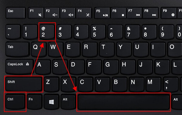
Комбинация клавиш Ctrl-Shift-2
Достаточно простой и удобный способ, но работает это только в Mictosoft Word.
Как поставить знак градуса без клавиатуры
Если вам не удается запомнить описанные выше комбинации клавиш, то возможно вам будет удобней вставлять знак градуса без использования клавиатуры. Это можно сделать при помощи программы « Таблица символов », которая есть в любой версии Windows, включая Windows 7 и Windows 10.
Для этого сначала нужно открыть программу « Таблица символов ». Например, вы можете нажать Windows-R и в появившемся окне выполнить команду « charmap.exe ».
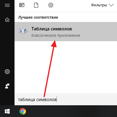
Также вы можете открыть « Таблицу символов » с помощью поиска в меню Пуск.
В « Таблице символов » нужно найти знак градуса, выделить его мышкой и нажать на кнопку « Выбрать ».
После этого нужно нажать на кнопку « Копировать » и вставить знак градуса в нужное место документа при помощи комбинации клавиш CTRL-V либо с помощью команды « Вставить ».
Таким образом можно поставить знак градуса в любом документе и любой программе.
Создатель сайта comp-security.net, автор более 2000 статей о ремонте компьютеров, работе с программами, настройке операционных систем.
Спасибо, первый способ попробовала и сразу получилось. Очень легко, понятно мне-чайнику. СПАСИБО!
первый способ самый лучший, легко запомнить для начинающих
С комбинациями вообще не получилось- рисует крупный квадрат, а в таблице символов сразу нашла, спасибо)))
спасибо, первый способ-самый быстрый и лучший
Большое спасибо. Требовалось вставить знак именно на сайте. Первые два способа не сработали, но вот третий сработал отлично.
Спасибо! Получилось сразу же первым способом!
С правым альтом как на картинке не работает! Только с левым.
Спасибо, получилось первым и вторым способами(третьим не пробовал), но нужно было ещё указать, что клавиатуру нужно перевести в ENG…
ЭДУАРД ВАЖНОЕ замечание, СПС.
У меня все работает и в русской раскладке клавиатуры.
Источник
Как поставить на клавиатуре значок градуса
Типографического символа, который служит для обозначения размерности величин, измеряемых в градусах, нет на клавиатуре компьютера, что вызывает у пользователей закономерный вопрос: как его поставить? Большинство людей находит выход из ситуации, копируя надстрочный кружочек из какого-либо другого источника, а затем вставляя его в собственный документ. Однако существует несколько простых способов создать символ градуса собственноручно.
Как напечатать символ градуса
В Windows
В программах пакета Microsoft Office (за исключением Microsoft Excel) можно воспользоваться ещё одним методом:
Кроме того, программа Microsoft Word умеет работать с шестнадцатеричными кодами юникод-таблицы, преобразуя их в соответствующие символы. Значку градуса соответствует код 00B0 — его следует набрать в том месте текста, где должен быть надстрочный кружок, а затем нажать комбинацию Alt+X. Word уберёт из текста шестнадцатеричный код, заменив его знаком °.
В Mac OS
Чтобы напечатать значок градуса в операционных системах семейства Mac OS, используют комбинацию клавиш Opt+Shift+8. Также можно использовать следующий способ:
Если знак градуса используется довольно часто, есть смысл добавить его в список избранных символов. Когда вы это сделаете, значок появится в верхней части окна, среди элементов быстрого доступа.
Значок градуса на мобильных устройствах
На телефонах и планшетах символ ° напечатать немного проще, чем на ПК, поскольку они имеют символьную клавиатуру, где отображаются значки.
На гаджетах под управлением андроид символ градуса набирают так:

Другие способы напечатать знак градуса
В операционной системе Windows можно вставить значок градуса в редактируемый документ при помощи таблицы символов. Зажмите на клавиатуре сочетание Win+R и введите в открывшемся окне команду charmap, после чего нажмите Enter. Перед вами откроется таблица символов. Найдите в ней знак градуса, кликните по нему два раза и нажмите «Копировать». Вернитесь к документу, с которым вы работаете, и вставьте значок в нужное место текста сочетанием клавиш Ctrl+V.
Таблицу символов также можно вызвать с помощью кнопки Пуск. Нажмите Пуск и введите в строке поиска запрос «Таблица символов». Программа отобразится в результатах поиска.
Если символ ° нужно поместить в текст веб-страницы, разместите в гипертекстовом документе последовательность символов ° либо ° — и первая, и вторая формируют необходимый знак.
Видео
Из видео вы узнаете, как поставить значок градуса ° в Ворде.
Источник
Форумы GIS-Lab.info
Геоинформационные системы (ГИС) и Дистанционное зондирование Земли
Координаты точек в градусах-минутах-секундах
Координаты точек в градусах-минутах-секундах
Сообщение Rayna » 19 май 2010, 11:59
Re: Предложения по улучшению QGIS
Сообщение Mavka » 19 май 2010, 12:21
Сообщение Rayna » 20 май 2010, 05:49
Re: Координаты точек в градусах-минутах-секундах
Сообщение Rayna » 20 май 2010, 05:51
Re: Координаты точек в градусах-минутах-секундах
Сообщение paleogis » 20 май 2010, 07:46
Re: Некоторым надо.
Сообщение Максим Дубинин » 20 май 2010, 07:50
Я сочуствую, что у вас нет программистов. Но вам придется их найти, так или иначе, что добавить нужную вам функциональность или ждать пока кто-то еще не решит эту задачу.
В принципе, с вашей задачей должен справиться практически любой начинающий специалист, имеющий представление о языке Python. Найдите студента или вытрясите с начальства средств на создание нужного вам инструмента, заинтересуйте человека как-нибудь.
Возможно, кто-то с этого форума захочет помочь запрограммировать нужную функциональность.
Еще, пересчитывать в формат DD MM SS.SS вы можете прямо в Excel’е из координат в формате DD.DDDD. Как, с примером таблицы, написано по ссылке выше.
UPD: Темы я объединил, они об одном и том же.
Источник
Форматы GPS координат
Многие любители отдыха на природе, а также автомобилисты и мотоциклисты активно пользуются GPS-навигаторами. Это могут быть как отдельные устройства, так и обычные смартфоны и планшеты со встроенным GPS-модулем и навигационным программным обеспечением. Пользоваться этими устройствами несложно, достаточно небольших навыков. Но когда речь заходит о системе координат GPS может возникнуть путаница из-за того, что нет общепринятого единого формата записи этих самых координат.
Типы координат GPS
Рядовому пользователю навигационной системы редко приходится сталкиваться с чтением и записью географических координат. Обычно достаточно вбить в навигатор нужный адрес или точку (POI), и устройство отобразит на карте нужное место и, при необходимости, проложит до него маршрут. Но более продвинутые пользователи GPS, например туристы и кладоискатели, нередко сталкиваются с необходимостью ручного ввода координат. И тут из-за отсутствия единого формата записи координат могут возникнуть трудности.
Существует 3 основных формата записи географических координат:
В качестве примера указаны координаты одного и того же места в г. Омске. Существуют и другие форматы, но они почти не используются в гражданских навигационных устройствах. Как видим, первые числа в координатах, т.е. целые части градусов, неизменны независимо от формата записи. А вот дробная часть градусов и минуты с секундами различны для одного и того же места. Т.е. если ввести координаты формата с минутами и секундами в навигатор, настроенный на формат градусов с дробью, то устройство отобразит место, которое может находиться в нескольких километрах от искомого. Либо выдаст ошибку о несоответствии типа координат.
Из-за этого и может возникнуть путаница: искали одно место, а пришли к другому. Чтобы этого не случилось, стоит понимать разницу между разными форматами записи координат и правильно настроить свое устройство. Большинство навигационных устройств и приложений для телефона поддерживают несколько форматов отображения координат, которые можно менять в настройках.


Наиболее распространен в настоящее время и формат градусов в виде десятичной дроби. Нередко к значениям координат могут добавляться буквы (N, S, E, W) или знаки («+», «-»), обозначающие тип широты (северная (N, «+»), южная (S, «-»)) и долготы (восточная (E, «+»), западная (W, «-»)). Знак «+» обычно не пишется. Иногда координаты могут записываться наоборот: сначала долгота, потом широта. Но такой тип записи используется редко.
Вывод
При необходимости можно всегда перевести координаты из одного вида в другой. Для этого достаточно помнить, что 1 градус равен 60 минутам, в каждой из которых по 60 секунд. Существуют специальные GPS конвертеры для телефона и онлайн сервисы для решения этой задачи. Но если пользоваться только одним форматом, желательно самым простым и распространенным (градусы с дробью, «54.97158, 73.38318»), то необходимость в конвертации координат возникает редко.
Читайте также:
Форматы GPS координат: 6 комментариев
Координаты вполне успешно гуглятся. Формат обычный, десятичный, но с меньшим количеством знаков после точки
Может быть 40-45 метров, а не километров? Давайте посчитаем: в 1 градусе широты примерно 111 км на любой долготе. В долготе это значение уменьшается при приближении к полюсам. Для простоты посчитаем на широте, а для еще большей простоты примем это значение за 100 км. Итак, в одном градусе — 100 км, в одном десятом градуса (1 знак после точки) — 10 км, в 1/100 градуса (2 знака) — 1 км, 3 знака — 100 м, 4 знака (как в вашем случае) — 10 метров. Возможно что-то напутал в расчетах, но не о каких 40-45 км речи даже близко не идет. Откуда вы это взяли? Просто введите свои координаты (N55.1374 E37.5728) в строку поиска Гугла, место отобразится на карте. Честно говоря, не понимаю, в чем проблема…
При необходимости можно всегда перевести координаты из одного вида в другой. Для этого достаточно помнить, что 1 градус равен 60 минутам, в каждой из которых по 60 секунд
И. …что это даёт без онлайн калькулятора?
То, что путем несложных вычислений можно перевести координаты из одной системы в другую без использования калькулятора
Источник
Загрузить PDF
Загрузить PDF
Широта и долгота — координаты на земном шаре, которые помогут вам найти определенное место. При написании широты и долготы стоит убедиться, что вы используете правильный формат и правильные символы, чтобы вас поняли. Можно определить положение различных точек широты и долготы на карте, а затем записать их. Можно записать широту и долготу, используя только значение параллели и меридиана. Для конкретных точек широты и долготы можно записать координаты с помощью градусов, минут, секунд и десятичных дробей.
-
1
Определите географическую долготу. Меридиан — линия долготы, идущая вертикально по всему шару, от Северного до Южного полюса. Нулевой (начальный) меридиан является точкой отсчета долготы. Это нулевая отметка. Еще она называется Гринвичским меридианом. При записи долготы используется символ ° для обозначения градусов.[1]
- Меридианы отсчитываются на восток и на запад от нулевого. При движении на восток величина географической долготы увеличивается на один градус для каждого последующего меридиана. Можно использовать сокращение «в. д.» («восточной долготы»; для международного обозначения используется буква «E» — East), чтобы обозначить долготу, расположенную восточнее нулевого меридиана. Например, географическая долгота может быть 30° в. д. (30°E).
- Если двигаться на запад, то величина географической долготы тоже увеличивается на один градус на каждом следующем меридиане. Географическая долгота, расположенная к западу от нулевого меридиана, обозначается сокращением «з. д.» («западной долготы»; для международного обозначения используется буква «W» — West). Например, географическая долгота может быть 15° з. д. (15°W).
-
2
Определите географическую широту. Географическая широта — горизонтальная линия (параллель), делящая земной шар. Параллели тянутся с востока на запад, начиная от экватора. Географическая широта экватора — 0 градусов. При записи широты для обозначения градусов используется символ °.[2]
- Если двигаться на север от экватора, то географическая широта с каждой параллелью увеличивается на 1 градус, пока не достигнет 90 градусов. На отметке 90 градусов находится Северный полюс. Географическая широта выше экватора обозначается сокращением «с. ш.» («северная широта»; для международного обозначения используется буква «N» — North). Например, географическая широта может быть 15° с. ш. (15°N).
- Если двигаться на юг от экватора, то географическая широта также увеличивается на 1 градус для каждой последующей параллели, пока не достигнет 90 градусов. Это точка Южного полюса. Для обозначения южной широты используйте сокращение «ю. ш.» (для международного обозначения используется буква «S» — South). Например, географическая широта может быть 30° ю. ш. (30°S).
-
3
Запишите координаты широты и долготы. Выберите точку и выясните, где пересекаются линии широты и долготы. Например, точку можно найти по координатам параллели 15° с. ш. и меридиана 30° в. д. При записи координат сначала идет широта, потом долгота (в международном написании они разделяются запятой).[3]
- Географическая широта и долгота, указанные выше, записываются как 15° с. ш. 30° в. д. (15°N, 30°E).
Реклама
-
1
Определите географическую широту и долготу. Иногда нужно указать более точное местоположение, чем номер параллели и меридиана, расстояние между которыми весьма велико. Значения географической широты и долготы можно разбить на минуты и секунды. Однако сначала нужно найти параллель и меридиан. Определите, рядом с какой параллелью и меридианом расположено выбранное место.[4]
- Например, это место расположено рядом с параллелью 15° с. ш. и меридианом 30° в. д.
-
2
Определите минуты между параллелями и меридианами. Расстояние между двумя параллелями и двумя меридианами равно 1 градусу. Этот градус можно разделить на минуты. Представьте, что существует 60 одинаковых минут, разделяющих соседние параллели и меридианы. Можно найти онлайн-карту, которая поможет определить точное значение минут для выбранного места. Для обозначения минут используется одинарный штрих (похож на апостроф).[5]
- Например, если нужно обозначить 23 минуты между параллелями, то они записываются так: 23′ .
-
3
Определите секунды между минутами. Минуты можно дальше разделить на секунды. Расстояние между каждыми двумя минутами составляет 60 секунд. И снова онлайн-карта поможет вам узнать точное количество секунд. Для обозначения секунд используется двойной штрих (похож на знак двойной кавычки).[6]
- Например, 15 секунд записываются как 15″.
-
4
Запишите градусы, затем минуты и в конце секунды. Когда вы определите точные координаты широты и долготы с минутами и секундами, запишите их в правильном порядке. Начните с широты: запишите градусы, минуты и секунды. Затем добавьте «с. ш.» или «ю. ш.» для указания полушария. Затем запишите долготу (при международном обозначении — отделите запятой): градусы, минуты и секунды. Затем добавьте «в. д.» или «з. д.» для указания расположения относительно Гринвича.[7]
- Например, предположим, что есть широта с координатами 15° с. ш., 24 минуты и 15 секунд. И долгота 30° в. д., 10 минут и 3 секунды.
- Эти координаты будут записаны как 15°24’15» с. ш. 30°10’3″ в. д..
Реклама
-
1
Определите координаты широты и долготы точки. Можно использовать минуты с десятыми долями для обозначения широты и долготы. Но все равно сначала нужно определить нужные параллель и меридиан. Выясните, где пересекаются параллель и меридиан, чтобы точно определить ваше местоположение.[8]
- Например, ваше местоположение 15° с. ш. 30° з. д.
-
2
Вычислите минуты с десятыми долями. На некоторых картах используются минуты с десятыми долями, а не минуты с секундами. Онлайн-карта сможет сообщить вам минуты с десятыми долями для значений широты и долготы. Например, широта может быть равна 23,0256 минут.[9]
-
3
Определите, является ли значение отрицательным или положительным. В системе с градусами и минутами с десятыми долями направления «север», «юг», «восток» и «запад» не используются. Вместо них используются положительные или отрицательные числа для определения точки на карте.[10]
- Не забывайте, что параллели проходят к северу или к югу от экватора. При использовании десятых долей для обозначения широты и долготы положительные значения расположены к северу от экватора, а отрицательные — к югу. Точка со значением 23,456 будет выше от экватора, а точка со значением -23,456 — ниже.
- Меридианы располагаются к востоку или западу от нулевого меридиана (Гринвича). Положительные значения обозначают точку к востоку от Гринвича, а отрицательные — к западу. Например, точка со значением 10,234 будет восточнее нулевого меридиана, а со значением -10,234 — западнее.
-
4
Запишите широту и долготу. Чтобы записать координаты, начните со значения широты. Запишите его минутами с десятыми долями. Затем запишите минутами с десятыми долями значение долготы (при международном обозначении широта и долгота разделяются запятой). Не забывайте использовать положительные и отрицательные значения для обозначения направления. В этом формате значок градуса не ставится.[11]
- Например, линия располагается на 15° с. ш. 30° в. д. (15°N, 30°W). Определите минуты и десятые доли и запишите координаты.
- Приведенный выше пример можно записать как 15 10,234, 30 -23,456.
Реклама
-
1
Определите координаты широты и долготы. Широта и долгота часто обозначаются десятичными градусами. Вместо минут и секунд линия в один градус делится с десятичными значениями, чтобы определить доли для точного местоположения. Для начала определите верные градусы широты и долготы.[12]
- Например, ваше местоположение 15° с. ш. 30° з. д.
-
2
Вычислите десятичные доли.Онлайн-карта может показать параллели и меридианы с использованием десятичных долей. Обычно после десятичной запятой записывают до пяти знаков.[13]
- Например, местоположение может быть 15,23456 на север и 30,67890 на запад.
-
3
Определите, являются ли значения положительными или отрицательными. Вместо слов «север», «юг», «восток» и «запад» для обозначения направления используются положительные или отрицательные числа. Для параллелей: значения линий, которые лежат к северу от экватора — положительные, и линии к югу от экватора — отрицательные. Для меридианов: линии к востоку от нулевого меридиана — положительные, и к западу от него — отрицательные.[14]
- Например, широта 15,23456 будет к северу от экватора, а широта -15,23456 — к югу.
- Долгота 30,67890 будет располагаться к востоку от нулевого меридиана, а -30,67890 — к западу.
-
4
Запишите широту и долготу, включая десятые доли. Десятичные градусы очень легко использовать. Просто запишите широту с десятыми долями, а за ней — долготу с десятыми долями. Используйте положительные или отрицательные числа для указания направления.[15]
- Например, координаты 15° с. ш. 30° з. д. в системе десятичных градусов можно записать как 15,23456, -30,67890.
Реклама
Об этой статье
Эту страницу просматривали 56 295 раз.
Была ли эта статья полезной?
Download Article
A guide to writing longitude & latitude in different formats, complete with examples
Download Article
- Writing Basic Latitude and Longitude
- Using Degrees, Minutes, and Seconds
- Using Degrees and Decimal Minutes
- Using Decimal Degrees
- Q&A
|
|
|
|
If you’ve ever read a map or a globe, you’re probably familiar with latitude and longitude. These coordinates can you help you pinpoint your exact location on Earth—but how do you write them? There are a few different methods for this, and with a little practice, they’re all easy to learn. This guide will teach you the four most common ways to write latitude and longitude. We’ve also thrown in some tips to help you understand how these coordinates work, plus instructions for finding latitude and longitude using globes, paper maps, and even modern software like Google Maps.
Things You Should Know
- Latitude and Longitude are written as two numbers. The numbers can be written in degrees, minutes, and seconds, (plus N, S, E, W), or in decimals degrees.
- Latitude indicates how far North or South a point is from the equator, while longitude indicates how far East or West a point is from the Prime Meridian.
- Each degree divides into 60 minutes, and each minute divides into 60 seconds. For example, 40°45’11″N is “40 degrees, 45 minutes, and 11 seconds North.”
- For example, New York City’s coordinates in degrees, minutes, & seconds are 40°45’11″N, 73°58’59″W—or 40.753056, -73.983056 in decimal degrees.
-
1
Identify lines of latitude. Lines of latitude run East to West, starting with the 0° line—a.k.a., the equator. Each line is labeled in degrees, followed by “N” for “North” or “S” for “South.” Lines to the North of the equator 0° will be labeled with an “N,” while lines to the South of the equator will have an “S.” The number of degrees increases as you move farther North or South of the equator.[1]
- For example, New York City is located close to latitude line 40°N. This means that New York City is 40 degrees North of the equator.
- Sydney, Australia, is located near the latitude line 34°S. This means that Sydney is 34 degrees South of the 0° equator.[2]
- Latitude lines range from 0°-180° North or South. Since 0° (the equator) sits exactly between the Northern and Southern hemispheres, 0°N and 0°S mean the same thing.
- 180°N is the geographic North Pole, while 180°S is the geographic South Pole. Since these are different locations, 180°N and 180°S are not the same.
-
2
Identify lines of longitude. The lines run North to South, beginning with the 0° longitude line located near London, U.K. Each line is labeled in degrees, followed by an “E” for “East” or a “W” for “West.” Lines to the East of 0° will be labeled with an “E,” while lines to the west of 0°will have a “W.” The number of degrees increases as you move farther East or West of 0°.[3]
- For example, New York City is located close to the longitude line 74°W. This means that New York City is 74 degrees west of the 0° longitude mark.
- Sydney, Australia, is located near the longitude line 150°E. This means that Sydney is 150 degrees east of the 0° longitude mark.
- The 0° longitude mark is called the prime meridian. Since it’s located exactly in between the Eastern and Western hemispheres, 0°E and 0°W mean the same thing.[4]
- The opposite line, 180°, runs North to South in the middle of the Pacific Ocean. As with 0°, 180°E and 180°W mean the same thing since the 180° line is located exactly between the Western and Eastern hemispheres.
Advertisement
-
3
Write the latitude and longitude coordinates of a specific location. The coordinates are always written with latitude first, followed by a comma, followed by longitude. For example, the latitude and longitude of New York City are roughly 40°N, 74°W. For Sydney, the coordinates are roughly 34°S, 150°E.[5]
- Your latitude and longitude won’t be exact when using a map or globe. For example, your map or globe may only show degrees in increments of 5° (that is, 40°, 45°, etc.). Use Google Maps to obtain more precise coordinates.
- For this exercise, you can use the latitude or longitude line nearest to the location you’re measuring. So for New York City, your coordinates might be 40°N, 75°W.
Advertisement
-
1
Use Google Maps to find the latitude and longitude of a specific location. Choose a specific city or location, then tap or right-click to read the latitude and longitude. Your coordinates will have decimal numbers after them. These will get converted to “minutes” and “seconds,” which are fractional portions of a degree.[6]
- On Google maps, your latitude and longitude will be displayed as positive or negative numbers, but no compass direction (that is, no N, S, E, or W). A positive latitude is East, while a negative latitude is West. A positive longitude is North, while a negative longitude is South.
- For example, New York City’s coordinates on Google Maps are roughly 40.753, -73.983. This means 40.753°N, 73.983°W.[7]
-
2
Multiply decimal parts of your degrees by 60 to convert them to minutes. Each degree is divided into 60 minutes, or 1/60 of a degree. Multiplying the decimal parts of your latitude and longitude by 60 gives you the number of minutes represented by the decimal. The minutes are written with an apostrophe. For example, 8 minutes would be written as 8′.[8]
- Let’s use New York City’s coordinates as an example: 40.753°N, 73.983°W. For latitude, the decimal part is .753. For longitude, the decimal part is .983.
- .753 x 60 = 45.18 minutes, written 45.18′.
- .983 x 60 = 58.98 minutes, written 58.98′
-
3
Multiply decimal parts of the minutes by 60 to convert them to seconds. Each minute can be further divided into 60 seconds, or 1/60 of a minute. Multiplying the decimal parts of the minutes by 60 gives you the number of seconds represented by the decimal. The seconds are written with two apostrophes. For example, 17 seconds would be written as 17″.[9]
- Let’s use New York City’s coordinates with minutes as an example: 40° and 45.18′ North for latitude, and 73° and 58.98′ West for longitude. For latitude, the decimal part of the minutes is .18. For longitude, the decimal part of the minutes is .98.
- .18 x 60 = 10.8, or roughly 11 seconds. This is written as 11″.
- .98 x 60 = 58.8, or roughly 59 seconds. This is written as 59″.
-
4
Write your latitude and longitude degrees, minutes, and seconds. After finding the precise coordinates in minutes and seconds for a specific location, write them out in the correct order. Start with your line of latitude, writing the degrees, minutes, and seconds. Add an N (for North) or S (for South) as the direction. Then, write a comma followed by your line of longitude in degrees, minutes, and seconds, adding an E (for East) or W (for West) as the direction.[10]
- For New York City, the latitude is 40 degrees, 45 minutes, and 11 seconds North. The longitude is 73 degrees, 58 minutes, and 59 seconds West.
- Therefore the latitude and longitude of New York City are written as 40°45’11″N, 73°58’59″W.
Advertisement
-
1
Use Google Maps to obtain the latitude and longitude. Pick a city or specific location, then tap or right-click to view the latitude and longitude. The coordinates will have decimal numbers after them. You’ll convert these decimals to “minutes,” which are fractions of a degree.[11]
- On Google maps, latitude and longitude are displayed with positive or negative numbers. They won’t have a compass direction (that is, they won’t have N, S, E, or W). A positive latitude is East, while a negative latitude is West. A positive longitude is North, while a negative longitude is South.
- For example, Sydney, Australia’s coordinates on Google Maps are roughly -33.868, 151.214. This means 33.868°S, 151.214°E.
-
2
Multiply decimal parts of the degrees by 60 to convert to minutes. Each degree on a map is divided into 60 minutes, or 1/60 of a degree. To calculate the number of minutes represented by the decimal parts of your latitude and longitude, multiply the decimal parts by 60. The minutes are written with an apostrophe. For example, 37.44 minutes would be written as 37.44′.[12]
- Let’s use Sydney, Australia’s coordinates as an example: 33.868°S, 151.214°E. For latitude, the decimal part is .868. For longitude, the decimal part is .214.
- .868 x 60 = 52.08 minutes, written 52.08′.
- .214 x 60 = 12.84 minutes, written 12.84′.
-
3
Write your latitude and longitude in degrees and minutes. After finding the precise coordinates in degrees and minutes for a specific location, write them out in the correct order. Start with your line of latitude, writing the degrees and minutes. Add North or South as the direction. Then, write a comma followed by your line of longitude in degrees and minutes, followed by East or West for the direction.[13]
- For Sydney, Australia, the latitude is 33 degrees and 52.08 South. The longitude is 151 degrees and 12.84 minutes East.
- Therefore the latitude and longitude of Sydney, Australia in decimal minutes are 33°52.08’S, 151°12.84’E.
Advertisement
-
1
Use Google Maps to find the latitude and longitude of a specific location. Choose a specific city or location, then tap or right-click to view the latitude and longitude. Your coordinates will be displayed in decimal minutes, without N, S, E, or W.[14]
- For example, your coordinates could be 15.23456 and 30.67890.
-
2
Identify whether numbers are positive or negative. Rather than using North, South, East, and West, positive or negative numbers are used. For lines of latitude, lines North of the equator are positive while lines South of the equator are negative. For lines of longitude, lines East of the Prime Meridian are positive while lines West of the Prime Meridian are negative.[15]
- For example, the line of latitude 15.23456 is north of the equator, while the line -15.23456 is south of the equator.
- The line of longitude written as 30.67890 is east of the Prime Meridian, while the line -30.67890 is west of the Prime Meridian.
-
3
Write latitude and longitude, including decimals. For decimal degrees, simply write out the line of latitude, including decimals, followed by the line of longitude, including decimals. Use positive or negative numbers to indicate direction.[16]
- For example, if your coordinates are 15.23456 degrees north and 30.67890 degrees West, you would write them as «15.23456, -30.67890.»
- For decimal degrees, you do not need to write the degree symbol.
Advertisement
Add New Question
-
Question
Are the digits to the right of the decimal point minutes and seconds respectively?
Usually if you see format 12.345678°, this is not minutes and seconds, but decimal degrees.
Ask a Question
200 characters left
Include your email address to get a message when this question is answered.
Submit
Advertisement
Thanks for submitting a tip for review!
References
About This Article
Article SummaryX
If you want to write latitude and longitude, first, identify the line of latitude on which a location sits. To find the latitude, look at the horizontal lines running north to south from the equator. Count the lines from the equator to the location and write down that number in degrees along with “N” or “S” depending on whether the location is north or south of the equator. Then, identify the line of longitude. Lines of longitude run vertically and stretch from east to west, so count each line between the location and the Prime Meridian to get its degrees. When you have that number, write it down in degrees and denote whether it lies east or west of the Prime Meridian. For example, a set of coordinates could look like “15 degrees N, 30 degrees E”. For more help, like how to write latitude and longitude using degrees, minutes, and seconds, scroll down.
Did this summary help you?
Thanks to all authors for creating a page that has been read 581,421 times.
Reader Success Stories
-
Mubarak Husain
Sep 30, 2020
«It fully covered the basics of the information on latitude and longitude. Further, I will love to find out latitude…» more
Did this article help you?
Download Article
A guide to writing longitude & latitude in different formats, complete with examples
Download Article
- Writing Basic Latitude and Longitude
- Using Degrees, Minutes, and Seconds
- Using Degrees and Decimal Minutes
- Using Decimal Degrees
- Q&A
|
|
|
|
If you’ve ever read a map or a globe, you’re probably familiar with latitude and longitude. These coordinates can you help you pinpoint your exact location on Earth—but how do you write them? There are a few different methods for this, and with a little practice, they’re all easy to learn. This guide will teach you the four most common ways to write latitude and longitude. We’ve also thrown in some tips to help you understand how these coordinates work, plus instructions for finding latitude and longitude using globes, paper maps, and even modern software like Google Maps.
Things You Should Know
- Latitude and Longitude are written as two numbers. The numbers can be written in degrees, minutes, and seconds, (plus N, S, E, W), or in decimals degrees.
- Latitude indicates how far North or South a point is from the equator, while longitude indicates how far East or West a point is from the Prime Meridian.
- Each degree divides into 60 minutes, and each minute divides into 60 seconds. For example, 40°45’11″N is “40 degrees, 45 minutes, and 11 seconds North.”
- For example, New York City’s coordinates in degrees, minutes, & seconds are 40°45’11″N, 73°58’59″W—or 40.753056, -73.983056 in decimal degrees.
-
1
Identify lines of latitude. Lines of latitude run East to West, starting with the 0° line—a.k.a., the equator. Each line is labeled in degrees, followed by “N” for “North” or “S” for “South.” Lines to the North of the equator 0° will be labeled with an “N,” while lines to the South of the equator will have an “S.” The number of degrees increases as you move farther North or South of the equator.[1]
- For example, New York City is located close to latitude line 40°N. This means that New York City is 40 degrees North of the equator.
- Sydney, Australia, is located near the latitude line 34°S. This means that Sydney is 34 degrees South of the 0° equator.[2]
- Latitude lines range from 0°-180° North or South. Since 0° (the equator) sits exactly between the Northern and Southern hemispheres, 0°N and 0°S mean the same thing.
- 180°N is the geographic North Pole, while 180°S is the geographic South Pole. Since these are different locations, 180°N and 180°S are not the same.
-
2
Identify lines of longitude. The lines run North to South, beginning with the 0° longitude line located near London, U.K. Each line is labeled in degrees, followed by an “E” for “East” or a “W” for “West.” Lines to the East of 0° will be labeled with an “E,” while lines to the west of 0°will have a “W.” The number of degrees increases as you move farther East or West of 0°.[3]
- For example, New York City is located close to the longitude line 74°W. This means that New York City is 74 degrees west of the 0° longitude mark.
- Sydney, Australia, is located near the longitude line 150°E. This means that Sydney is 150 degrees east of the 0° longitude mark.
- The 0° longitude mark is called the prime meridian. Since it’s located exactly in between the Eastern and Western hemispheres, 0°E and 0°W mean the same thing.[4]
- The opposite line, 180°, runs North to South in the middle of the Pacific Ocean. As with 0°, 180°E and 180°W mean the same thing since the 180° line is located exactly between the Western and Eastern hemispheres.
Advertisement
-
3
Write the latitude and longitude coordinates of a specific location. The coordinates are always written with latitude first, followed by a comma, followed by longitude. For example, the latitude and longitude of New York City are roughly 40°N, 74°W. For Sydney, the coordinates are roughly 34°S, 150°E.[5]
- Your latitude and longitude won’t be exact when using a map or globe. For example, your map or globe may only show degrees in increments of 5° (that is, 40°, 45°, etc.). Use Google Maps to obtain more precise coordinates.
- For this exercise, you can use the latitude or longitude line nearest to the location you’re measuring. So for New York City, your coordinates might be 40°N, 75°W.
Advertisement
-
1
Use Google Maps to find the latitude and longitude of a specific location. Choose a specific city or location, then tap or right-click to read the latitude and longitude. Your coordinates will have decimal numbers after them. These will get converted to “minutes” and “seconds,” which are fractional portions of a degree.[6]
- On Google maps, your latitude and longitude will be displayed as positive or negative numbers, but no compass direction (that is, no N, S, E, or W). A positive latitude is East, while a negative latitude is West. A positive longitude is North, while a negative longitude is South.
- For example, New York City’s coordinates on Google Maps are roughly 40.753, -73.983. This means 40.753°N, 73.983°W.[7]
-
2
Multiply decimal parts of your degrees by 60 to convert them to minutes. Each degree is divided into 60 minutes, or 1/60 of a degree. Multiplying the decimal parts of your latitude and longitude by 60 gives you the number of minutes represented by the decimal. The minutes are written with an apostrophe. For example, 8 minutes would be written as 8′.[8]
- Let’s use New York City’s coordinates as an example: 40.753°N, 73.983°W. For latitude, the decimal part is .753. For longitude, the decimal part is .983.
- .753 x 60 = 45.18 minutes, written 45.18′.
- .983 x 60 = 58.98 minutes, written 58.98′
-
3
Multiply decimal parts of the minutes by 60 to convert them to seconds. Each minute can be further divided into 60 seconds, or 1/60 of a minute. Multiplying the decimal parts of the minutes by 60 gives you the number of seconds represented by the decimal. The seconds are written with two apostrophes. For example, 17 seconds would be written as 17″.[9]
- Let’s use New York City’s coordinates with minutes as an example: 40° and 45.18′ North for latitude, and 73° and 58.98′ West for longitude. For latitude, the decimal part of the minutes is .18. For longitude, the decimal part of the minutes is .98.
- .18 x 60 = 10.8, or roughly 11 seconds. This is written as 11″.
- .98 x 60 = 58.8, or roughly 59 seconds. This is written as 59″.
-
4
Write your latitude and longitude degrees, minutes, and seconds. After finding the precise coordinates in minutes and seconds for a specific location, write them out in the correct order. Start with your line of latitude, writing the degrees, minutes, and seconds. Add an N (for North) or S (for South) as the direction. Then, write a comma followed by your line of longitude in degrees, minutes, and seconds, adding an E (for East) or W (for West) as the direction.[10]
- For New York City, the latitude is 40 degrees, 45 minutes, and 11 seconds North. The longitude is 73 degrees, 58 minutes, and 59 seconds West.
- Therefore the latitude and longitude of New York City are written as 40°45’11″N, 73°58’59″W.
Advertisement
-
1
Use Google Maps to obtain the latitude and longitude. Pick a city or specific location, then tap or right-click to view the latitude and longitude. The coordinates will have decimal numbers after them. You’ll convert these decimals to “minutes,” which are fractions of a degree.[11]
- On Google maps, latitude and longitude are displayed with positive or negative numbers. They won’t have a compass direction (that is, they won’t have N, S, E, or W). A positive latitude is East, while a negative latitude is West. A positive longitude is North, while a negative longitude is South.
- For example, Sydney, Australia’s coordinates on Google Maps are roughly -33.868, 151.214. This means 33.868°S, 151.214°E.
-
2
Multiply decimal parts of the degrees by 60 to convert to minutes. Each degree on a map is divided into 60 minutes, or 1/60 of a degree. To calculate the number of minutes represented by the decimal parts of your latitude and longitude, multiply the decimal parts by 60. The minutes are written with an apostrophe. For example, 37.44 minutes would be written as 37.44′.[12]
- Let’s use Sydney, Australia’s coordinates as an example: 33.868°S, 151.214°E. For latitude, the decimal part is .868. For longitude, the decimal part is .214.
- .868 x 60 = 52.08 minutes, written 52.08′.
- .214 x 60 = 12.84 minutes, written 12.84′.
-
3
Write your latitude and longitude in degrees and minutes. After finding the precise coordinates in degrees and minutes for a specific location, write them out in the correct order. Start with your line of latitude, writing the degrees and minutes. Add North or South as the direction. Then, write a comma followed by your line of longitude in degrees and minutes, followed by East or West for the direction.[13]
- For Sydney, Australia, the latitude is 33 degrees and 52.08 South. The longitude is 151 degrees and 12.84 minutes East.
- Therefore the latitude and longitude of Sydney, Australia in decimal minutes are 33°52.08’S, 151°12.84’E.
Advertisement
-
1
Use Google Maps to find the latitude and longitude of a specific location. Choose a specific city or location, then tap or right-click to view the latitude and longitude. Your coordinates will be displayed in decimal minutes, without N, S, E, or W.[14]
- For example, your coordinates could be 15.23456 and 30.67890.
-
2
Identify whether numbers are positive or negative. Rather than using North, South, East, and West, positive or negative numbers are used. For lines of latitude, lines North of the equator are positive while lines South of the equator are negative. For lines of longitude, lines East of the Prime Meridian are positive while lines West of the Prime Meridian are negative.[15]
- For example, the line of latitude 15.23456 is north of the equator, while the line -15.23456 is south of the equator.
- The line of longitude written as 30.67890 is east of the Prime Meridian, while the line -30.67890 is west of the Prime Meridian.
-
3
Write latitude and longitude, including decimals. For decimal degrees, simply write out the line of latitude, including decimals, followed by the line of longitude, including decimals. Use positive or negative numbers to indicate direction.[16]
- For example, if your coordinates are 15.23456 degrees north and 30.67890 degrees West, you would write them as «15.23456, -30.67890.»
- For decimal degrees, you do not need to write the degree symbol.
Advertisement
Add New Question
-
Question
Are the digits to the right of the decimal point minutes and seconds respectively?
Usually if you see format 12.345678°, this is not minutes and seconds, but decimal degrees.
Ask a Question
200 characters left
Include your email address to get a message when this question is answered.
Submit
Advertisement
Thanks for submitting a tip for review!
References
About This Article
Article SummaryX
If you want to write latitude and longitude, first, identify the line of latitude on which a location sits. To find the latitude, look at the horizontal lines running north to south from the equator. Count the lines from the equator to the location and write down that number in degrees along with “N” or “S” depending on whether the location is north or south of the equator. Then, identify the line of longitude. Lines of longitude run vertically and stretch from east to west, so count each line between the location and the Prime Meridian to get its degrees. When you have that number, write it down in degrees and denote whether it lies east or west of the Prime Meridian. For example, a set of coordinates could look like “15 degrees N, 30 degrees E”. For more help, like how to write latitude and longitude using degrees, minutes, and seconds, scroll down.
Did this summary help you?
Thanks to all authors for creating a page that has been read 581,421 times.
Reader Success Stories
-
Mubarak Husain
Sep 30, 2020
«It fully covered the basics of the information on latitude and longitude. Further, I will love to find out latitude…» more
Did this article help you?
Похоже, вы используете блокировщик рекламы. Наш сайт существует и развивается
только за счет дохода от рекламы.
Пожалуйста, добавьте нас в исключения блокировщика.
на главную
Как найти координаты точки
Поддержать сайт
Каждой точке координатной плоскости соответствуют две координаты.
Координаты точки на плоскости — это пара чисел, в которой на
первом месте стоит
абсцисса, а на
втором —
ордината точки.
Рассмотрим как в системе координат (на координатной плоскости):
- находить координаты точки;
- найти положение точки.
Чтобы найти координаты точки на плоскости, нужно опустить из этой точки
перпендикуляры на оси координат.
Точка пересечения с осью «x» называется абсциссой точки «А»,
а с осью y называется ординатой точки «А».
Обозначают координаты точки, как указано выше (·) A (2; 3).
Пример (·) A (2; 3) и (·) B (3; 2).
Запомните!
На первом месте записывают абсциссу (координату по оси «x»), а на втором —
ординату (координату по оси «y») точки.
Особые случаи расположения точек
- Если точка лежит на оси «Oy»,
то её абсцисса равна 0. Например,
точка С (0, 2). - Если точка лежит на оси «Ox», то её ордината равна 0.
Например,
точка F (3, 0). - Начало координат — точка O имеет координаты, равные нулю O (0,0).
- Точки любой прямой перпендикулярной оси абсцисс, имеют одинаковые абсциссы.
- Точки любой прямой перпендикулярной оси ординат, имеют одинаковые ординаты.
- Координаты любой точки, лежащей на оси абсцисс имеют вид (x, 0).
- Координаты любой точки, лежащей на оси ординат имеют вид (0, y).
Как найти положение точки по её координатам
Найти точку в системе координат можно двумя способами.
Первый способ
Чтобы определить положение точки по её координатам,
например, точки D (−4 , 2), надо:
- Отметить на оси «Ox», точку с координатой
«−4», и провести через неё прямую перпендикулярную оси «Ox». - Отметить на оси «Oy»,
точку с координатой 2, и провести через неё прямую перпендикулярную
оси «Oy». - Точка пересечения перпендикуляров (·) D — искомая точка.
У неё абсцисса равна «−4», а ордината равна 2.
Второй способ
Чтобы найти точку D (−4 , 2) надо:
- Сместиться по оси «x» влево на
4 единицы, так как у нас
перед 4
стоит «−». - Подняться из этой точки параллельно оси y вверх на 2 единицы, так
как у нас перед 2 стоит «+».
Чтобы быстрее и удобнее было находить координаты точек или строить точки по координатам на
листе формата A4 в клеточку, можно скачать и использовать
готовую систему координат на нашем сайте.
-
-
April 15 2011, 12:37
- Компьютеры
- Cancel
Как вводить символы, отсутствующие на клавиатуре
Для таких же не знающих, как и я.
Оказывается, чтобы написать специальный символ, например градус ° или евро €, не надо вбивать в Яндексе «градус цельсия» и оттуда его копировать.
Достаточно зажать клавишу Alt и знать комбинацию цифр, вот примеры:
пожалуй самые ходовые:
0136 € символ евро
0149 • «жирная» точка по центру
0153 ™ символ trade mark
0167 § параграф
0169 © символ копирайта
0174 ®
0176 ° символ градуса
0177 ±
и ещё:
0123 (или 123) {
0124 (или 124) |
0125 (или 125) }
0126 (или 126) ~
0130 ‚ нижняя одинарная кавычка
0132 „ открывающая «лапка»
0133 … многоточие
0134 † крестик (dagger)
0135 ‡ двойной крестик (double dagger)
0137 ‰ символ промилле
0139 ‹ левый «уголок»
0143 Џ
0145 ‘ верхняя одинарная кавычка (перевернутый апостроф)
0146 ’ апостроф
0147 “ закрывающая «лапка»
0148 ” английская закрывающая «лапка»
0150 – короткое тире (минус)
0151 — тире
0155 › правый «уголок»
0159 џ
0166 ¦
0171 « открывающая «ёлочка»
0172 ¬
0181 µ
0182 ¶
0183 · точка по центру
0185 №
0187 » закрывающая «ёлочка»
Можно запомнить, можно напечатать и иметь под рукой, удобно.
Ещё важно — цифры надо набирать на блоке дополнительной цифровой клавиатуры, т.е. она должна быть включена, и лампочка Num Lock должна гореть.
Потренироваться можно в комментариях.
Полезный Up 
Как вводить координаты
Координаты местности при вводе в поисковую систему могут не распознаться. Всегда руководствуйтесь особенностями сервиса, поскольку они могут различаться.
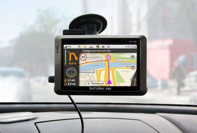
Вам понадобится
- — доступ к интернету.
Инструкция
Для того чтобы ввести координаты определенного месторасположения на картах в режиме онлайн, введите значения широты и долготы в строке поиска. Для получения наиболее точных результатов переведите секунды в доли минут, поскольку некоторые сервисы не смогут их распознать. Чем больше знаков будет после запятой, тем больше вероятности получить более подробную карту. Данные вводятся в поисковой строке Google, Yandex или любой другой поисковой системы, которой вы пользуетесь, в разделе «Карты».
Для получения точных координат местонахождения определенного интересующего вас объекта узнайте его точный адрес, после чего введите его в строку используемой вами поисковой системы. В разделе «Карты» будет выведена информация касательно координат.
Для ввода координат определенного объекта в навигатор воспользуйтесь соответствующем меню программного обеспечения. Обратите внимание, что в зависимости от используемого вами оборудования и загруженных карт вы можете получить информацию разной точности.
Старайтесь использовать наиболее подробные карты для вашего навигатора, в особенности это касается карт местности, в которой вам часто приходится бывать. Если вас не устраивают карты в вашем навигаторе, замените их, также при необходимости смените программное обеспечение устройства. Обратите внимание, что многие из данных элементов не являются бесплатными, их загрузка и последующее обновление может потребовать наличие у вас средств оплаты в режиме онлайн.
При выборе карт и программного обеспечения для навигатора обращайте внимание также на соответствие модели устройства. Если вы используете навигатор телефона, вам будет намного проще сориентироваться в выборе. Не пользуйтесь взломанными программами для вашего навигатора и старайтесь не нарушать условия договора с разработчиком.
Видео по теме
Полезный совет
Старайтесь использовать наиболее точные значения.
Войти на сайт
или
Забыли пароль?
Еще не зарегистрированы?
This site is protected by reCAPTCHA and the Google Privacy Policy and Terms of Service apply.


