Всего найдено: 5
Добрый день, уважаемая грамота! Интересует написание некоторых географических названий.
У вас размещено правило (http://www.gramota.ru/spravka/rules/?rub=mtz):
Буква ь не пишется: В прилагательных с суффиксом -ск-, образованных от существительных на ь, например: казанский (Казань), кемский (Кемь), сибирский (Сибирь), зверский (зверь), январский (январь).
Возник вопрос: почему ь сохраняется в словах гомельский, мариупольский, ставропольский?
У Розенталя находим более точное правило:
Если основа имени существительного оканчивается на -нь и -рь, то перед суффиксом -ск- буква ь не пишется, например: конь – конский, зверь – зверский, Рязань – рязанский, Сибирь – сибирский, Тюмень – тюменский.
(Далее и там и там даются исключения – прилагательные, образованные от названий месяцев и от некоторых иноязычных географических наименований, в частности китайских.)
Вопрос по поводу прилагательных на -льский от основ на -ль снялся сам собой, но возник еще один вопрос. Как тогда быть с прилагательными от основ на -мь? Пермь и Кемь образуют пермский и кемский. Чем это объяснить, если у Розенталя упоминаются только слова на -нь и -рь?
И последнее: от чего зависит наличие/отсутствие ь в прилагательных от слов на -л/-ль: байкальский от Байкал, уральский от Урал, барнаульский от Барнаул? Л всегда смягчается? И как правильно: кызылский или кызыльский?
Спасибо!
Ответ справочной службы русского языка
Вот что написано о прилагательных с суфиксом —ск— в полном академическом справочнике «Правила русской орфографии и пунктуации» под ред. В. В. Лопатина:
«В большинстве прилагательных с суффиксом —ск— согласный л перед суффиксом мягкий, поэтому после л пишется ь, например: сельский, уральский, барнаульский. Однако в некоторых прилагательных, образованных от нерусских собственных географических названий, сохраняется твердый л, поэтому ь не пишется, например: кызылский, ямалский (наряду с вариантами кызыльский, ямальский)».
«В большинстве прилагательных с суффиксом —ск— согласные н и р перед суффиксом – твердые, поэтому ь в них не пишется: конский, казанский, тюменский, рыцарский, январский, егерский. Однако в следующих прилагательных эти согласные перед суффиксом -ск- мягкие, в них после н и р пишется ь: день-деньской, июньский, сентябрьский, октябрьский, ноябрьский, декабрьский, а также во многих прилагательных, образованных от нерусских собственных географических названий на -нь, например: тянь-шаньский, тайваньский, пномпеньский, торуньский, сычуаньский, тяньцзиньский».
Что касается слов пермский и кемский, то мягкий знак в них не пишется по простой причине: согласный м произносится перед суффиксом —ск— твердо.
Добрый день! Подскажите, пожалуйста, как правильно написать: тянь-шанский медведь или Тянь-шанский? Заранее спасибо!
Ответ справочной службы русского языка
Правильно: тянь-шаньский медведь.
Нужна ли запятая после слова «известно»? Как известно, Тянь-Шань является одним из ярких примеров внутриконтинентального горообразования
Ответ справочной службы русского языка
Запятая поставлена верно.
как пишется слово тяньшаньский
Ответ справочной службы русского языка
Правильно: _тянь-шаньский_ (от _Тянь-Шань_), но: _Семёнов-Тян-Шанский_.
Большое спасибо за ответ на вопрос №199972 , но, к сожалению, вы не сказали, на основании какого правила следует так писать. У нас в редакции существуют разные
мнения на этот счет. Я склоняюсь к вашему, но мне показывают «Справочную книгу редактора и корректора» (М.: Книга, 1985): в разделе 3.6.13 (Неофициальные названия географических единиц, ЧАСТЕЙ СТРАН)говорится,
что «в этих названиях все слова,кроме родовых, пишут с прописной буквы»; приводят много примеров, но почти все они, по-моему, не могут иллюстрировать именно мой вопрос, так как относятся к названиям известных
исторических областей (Северный Кавказ,Средняя Азия и т.п.). И все же один пример, возможно, не входит в этот ряд — Центральный Тянь-Шань (если следовать вашему совету, первое слово следует писать со строчной буквы). К тому же там говорится обо всех названиях, а не только о ТЕРМИНОЛОГИЧЕСКИХ. В общем, очень прошу объяснить, на основании какого правила в описанных случаях нужно выбирать строчную или прописную букву.
С уважением, Елена.
Ответ справочной службы русского языка
Сочетания _северная Словакия, центральная Румыния, южная Нигерия_ не являются устоявшимися неофициальными названиями частей стран (как, например, Северный Кавказ), а представляют собой свободные сочетания, в которых слова _северная, центральная, южная_ указывают на географическое положение. Поэтому, по нашему мнению, оснований для того, чтобы писать оба слова с большой буквы, нет.
Разбор слова «тяньшань»: для переноса, на слоги, по составу
Объяснение правил деление (разбивки) слова «тяньшань» на слоги для переноса.
Онлайн словарь Soosle.ru поможет: фонетический и морфологический разобрать слово «тяньшань» по составу, правильно делить на слоги по провилам русского языка, выделить части слова, поставить ударение, укажет значение, синонимы, антонимы и сочетаемость к слову «тяньшань».
![]()
Как перенести слово «тяньшань»
тя—ньшань
тянь—шань
Как правильно пишется слово «тяньшань»
Правописание слова «тяньшань»
Орфография слова «тяньшань»
Правильно слово пишется:
Нумерация букв в слове
Номера букв в слове «тяньшань» в прямом и обратном порядке:
| В Википедии есть статья «Тянь-Шань». |
Содержание
- 1 Русский
- 1.1 Морфологические и синтаксические свойства
- 1.2 Произношение
- 1.3 Семантические свойства
- 1.3.1 Значение
- 1.3.2 Синонимы
- 1.3.3 Антонимы
- 1.3.4 Гиперонимы
- 1.3.5 Гипонимы
- 1.4 Родственные слова
- 1.5 Этимология
- 1.6 Фразеологизмы и устойчивые сочетания
- 1.7 Перевод
- 1.8 Библиография
Русский[править]
Морфологические и синтаксические свойства[править]
| падеж | ед. ч. | мн. ч. |
|---|---|---|
| Им. | Тя̀нь-Ша́нь | Тя̀нь-Ша́ни |
| Р. | Тя̀нь-Ша́ня | Тя̀нь-Ша́ней |
| Д. | Тя̀нь-Ша́ню | Тя̀нь-Ша́ням |
| В. | Тя̀нь-Ша́нь | Тя̀нь-Ша́ни |
| Тв. | Тя̀нь-Ша́нем | Тя̀нь-Ша́нями |
| Пр. | Тя̀нь-Ша́не | Тя̀нь-Ша́нях |
Тя̀нь-Ша́нь
Существительное, неодушевлённое, мужской род, 2-е склонение (тип склонения 2a по классификации А. А. Зализняка).
Производное: ??.
Корень: —.
Произношение[править]
- МФА: [ˌtʲænʲ ˈʂanʲ]
Семантические свойства[править]
Значение[править]
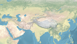
- горная система, расположенная в Центральной Азии на территории пяти стран: Киргизии, Казахстана, Китая, Таджикистана и Узбекистана ◆ Отсутствует пример употребления (см. рекомендации).
Синонимы[править]
Антонимы[править]
Гиперонимы[править]
Гипонимы[править]
Родственные слова[править]
| Ближайшее родство | |
Этимология[править]
От кит. 天山 (тяньшань) «небесные горы», далее от кит. 天 (тянь) «небо», «бог» + кит. 山 (шань) «гора».
Фразеологизмы и устойчивые сочетания[править]
Перевод[править]
| Список переводов | |
Библиография[править]
|
|
Для улучшения этой статьи желательно:
|
Толковый словарь русского языка. Поиск по слову, типу, синониму, антониму и описанию. Словарь ударений.
тянь-шань
ЭНЦИКЛОПЕДИЧЕСКИЙ СЛОВАРЬ
Тянь-Шань — горная система в Средней и Центральной Азии, главным образом на территории Киргизии и Китая; северный и западный хребты — в Казахстане, юго-западная оконечность — в Узбекистане. Длина с запада на восток около 2500 км. Наибольшие вершины — в Центральном Тянь-Шане (пик Победы, 7439 м, Хан-Тенгри и др.), от которого к западу расходятся 3 горных цепи, разделённые межгорными котловинами (Иссык-Кульская с озером Иссык-Куль, Нарынская, Ат-Башынская и др.) и соединённые на западе Ферганским хребтом. В Восточном Тянь-Шане — 2 параллельные горные цепи (высотой 4-5 тыс. м), разделённые впадинами (высота 2-3 тыс. м). Характерны высокоподнятые (3-4 тыс. м) выровненные поверхности — сырты. Ледники (общая площадь 7,3 тыс. км2, наиболее крупный — Южный Энгильчек). Порожистые реки (Нарын, Чу, Или и др.). Господствуют горные степи и полупустыни; на северных склонах — также лугостепи и леса (главным образом хвойные), выше — субальпийские и альпийские луга, на сыртах — так называемые холодные пустыни. В северном обрамлении Ферганской котловины — уникальные реликтовые орехоплодовые леса. Заповедники: Иссык-Кульский, Алма-Атинский, Аксу-Джабаглы, Сары-Челекский, Чаткальский и др.
* * *
ТЯНЬ-ШАНЬ — ТЯНЬ-ШАНЬ, горная система в Ср. и Центр. Азии, на территории Киргизии и Китая; северные и западные хребты в Казахстане. Длина с запада на востоке ок. 2500 км. Наибольшие вершины в Центр. Тянь-Шане (пик Победы (см. ПОБЕДЫ ПИК), 7439 м, Хан-Тенгри (см. ХАН-ТЕНГРИ) и др.), от которого к западу расходятся три горные цепи, разделенные межгорными котловинами (Иссык-Кульская (см. ИССЫК-КУЛЬСКАЯ КОТЛОВИНА) с оз. Иссык-Куль, Нарынская, Ат-Башынская и др.) и соединенные на западе Ферганским хр. (см. ФЕРГАНСКИЙ ХРЕБЕТ) В Вост. Тянь-Шане (см. ТЯНЬ-ШАНЬ ВОСТОЧНЫЙ) — 2 параллельные горные цепи (высота 4-5 тыс. м.), разделенные впадинами (глубина 2-3 тыс. м). Характерны высокоподнятые (3-4 тыс. м) выровненные поверхности — сырты (см. СЫРТЫ). Ледники (общая площадь 7,3 тыс. км2, наиболее крупный — Юж. Энгильчек (см. ЭНГИЛЬЧЕК)). Порожистые реки (Нарын (см. НАРЫН (река)), Чу (см. ЧУ (река)), Или (см. ИЛИ (река)) и др.). Господствуют горные степи и полупустыни; на северных склонах — также лугостепи и леса (главным образом хвойные); выше — субальпийские и альпийские луга; на сыртах — т. н. холодные пустыни. В северном обрамлении Ферганской котловины — уникальные реликтовые орехоплодовые леса. Заповедники: Иссык-Кульский (см. ИССЫК-КУЛЬСКИЙ ЗАПОВЕДНИК), Алма-Атинский (см. АЛМА-АТИНСКИЙ ЗАПОВЕДНИК), Аксу-Джабаглы, Сары-Челекский (см. САРЫ-ЧЕЛЕКСКИЙ ЗАПОВЕДНИК), Чаткальский и др.
БОЛЬШОЙ ЭНЦИКЛОПЕДИЧЕСКИЙ СЛОВАРЬ
ТЯНЬ-ШАНЬ — горная система в Ср. и Центр. Азии, на территории Киргизии и Китая; северные и западные хребты в Казахстане. Длина с запада на востоке ок. 2500 км. Наибольшие вершины в Центр. Тянь-Шане (пик Победы, 7439 м, Хан-Тенгри и др.), от которого к западу расходятся 3 горные цепи, разделенные межгорными котловинами (Иссык-Кульская с оз. Иссык-Куль, Нарынская, Ат-Башынская и др.) и соединенные на западе Ферганским хр. В Вост. Тянь-Шане — 2 параллельные горные цепи (высота 4-5 тыс. м.), разделенные впадинами (высота 2-3 тыс. м). Характерны высокоподнятые (3-4 тыс. м) выровненные поверхности — сырты. Ледники (общая площадь 7,3 тыс. км², наиболее крупный — Юж. Энгильчек). Порожистые реки (Нарын, Чу, Или и др.). Господствуют горные степи и полупустыни; на северных склонах — также лугостепи и леса (главным образом хвойные), выше — субальпийские и альпийские луга, на сыртах — т. н. холодные пустыни. В северном обрамлении Ферганской котловины — уникальные реликтовые орехоплодовые леса. Заповедники: Иссык-Кульский, Алма-Атинский, Аксу-Джабаглы, Сары-Челекский, Чаткальский и др.
ИЛЛЮСТРИРОВАННЫЙ ЭНЦИКЛОПЕДИЧЕСКИЙ СЛОВАРЬ

Тянь-Шань. Еловые леса.
ТЯНЬ-ШАНЬ, горная система в Средней и Центральной Азии, в Киргизии и Китае. Высшие точки — пик Победы (7439 м) и Хан-Тенгри (6995 м). Преобладает высокогорный рельеф с ледниковыми формами; на склонах — осыпи. Крупные межгорные (Ферганская, Иссык-Кульская, Нарынская) и окраинные (Чуйская, Таласская) долины. Тянь-Шань — значительный центр современного оледенения; крупнейшие ледники: Северный (38,2 км) и Южный (59,5 км) Энгильчек. Главные реки: Нарын, Сары-Джаз, Чу, Или. Крупнейшие озера: Иссык-Куль, Сонг-Кель, Чатыр-Кель. Характерны горные степи и полупустыни. Заповедники (Иссык-Кульский, Чаткальский и др.). Месторождения руд ртути, сурьмы, свинца, цинка, серебра, олова, вольфрама; во впадинах — нефти, каменного и бурого угля.
СИНОНИМЫ
сущ., кол-во синонимов: 3
ГРАММАТИЧЕСКИЙ СЛОВАРЬ
ПОЛЕЗНЫЕ СЕРВИСЫ
тянь-шань восточный
ЭНЦИКЛОПЕДИЧЕСКИЙ СЛОВАРЬ
ТЯНЬ-ШАНЬ ВОСТОЧНЫЙ — ТЯНЬ-ШАНЬ ВОСТО́ЧНЫЙ, название восточной части Тянь-Шаня (см. ТЯНЬ-ШАНЬ) на территории Китая (см. КИТАЙ).
ПОЛЕЗНЫЕ СЕРВИСЫ
тянь-шаньский
СЛИТНО. РАЗДЕЛЬНО. ЧЕРЕЗ ДЕФИС
ОРФОГРАФИЧЕСКИЙ СЛОВАРЬ
тянь-ша́ньский (от Тянь-Ша́нь), но: Семёнов-Тян-Ша́нский
МОРФЕМНО-ОРФОГРАФИЧЕСКИЙ СЛОВАРЬ
ПОЛЕЗНЫЕ СЕРВИСЫ
From Wikipedia, the free encyclopedia
| Tian Shan 天山 | |
|---|---|
| Tengri Tagh, Tengir-Too | |

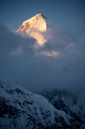
The Tian Shan range on the border between China, Kazakhstan and Kyrgyzstan with Khan Tengri (7,010 m) visible at center |
|
| Highest point | |
| Peak | Jengish Chokusu |
| Elevation | 7,439 m (24,406 ft) |
| Coordinates | 42°02′06″N 80°07′32″E / 42.03500°N 80.12556°E |
| Geography | |
|
|
|
| Countries | China, Kazakhstan, Kyrgyzstan, Uzbekistan and Tajikistan |
| Range coordinates | 42°N 80°E / 42°N 80°ECoordinates: 42°N 80°E / 42°N 80°E |
| Geology | |
| Age of rock | Mesozoic and Cenozoic |
|
UNESCO World Heritage Site |
|
| Official name | Xinjiang Tianshan |
| Type | Natural |
| Criteria | vii, ix |
| Designated | 2013 (37th session) |
| Reference no. | 1414 |
| Region | Asia |
|
UNESCO World Heritage Site |
|
| Official name | Western Tien-Shan |
| Type | Natural |
| Criteria | x |
| Designated | 2016 (40th session) |
| Reference no. | 1490 |
| Region | Asia |

The Tian Shan,[note 1] also known as the Tengri Tagh[1] or Tengir-Too,[2] meaning the Mountains of Heaven or the Heavenly Mountain, is a large system of mountain ranges in Central Asia. The highest peak in the Tian Shan is Jengish Chokusu, at 7,439 metres (24,406 ft) high. Its lowest point is the Turpan Depression, which is 154 m (505 ft) below sea level.[3]
One of the earliest historical references to these mountains may be related to the Xiongnu word Qilian (traditional Chinese: 祁連; simplified Chinese: 祁连; pinyin: Qílián) – according to Tang commentator Yan Shigu, Qilian is the Xiongnu word for sky or heaven.[4] Sima Qian in the Records of the Grand Historian mentioned Qilian in relation to the homeland of the Yuezhi and the term is believed to refer to the Tian Shan rather than the Qilian Mountains 1,500 kilometres (930 mi) further east now known by this name.[5][6] The Tannu-Ola mountains in Tuva has the same meaning in its name («heaven/celestial mountains» or «god/spirit mountains»). The name in Chinese, Tian Shan, is most likely a direct translation of the traditional Kyrgyz name for the mountains, Teñir Too.[1] The Tian Shan is sacred in Tengrism, and its second-highest peak is known as Khan Tengri which may be translated as «Lord of the Spirits».[7] At the 2013 Conference on World Heritage, the eastern portion of Tian Shan in western China’s Xinjiang Region was listed as a World Heritage Site.[8] The western portion in Kazakhstan, Kyrgyzstan, and Uzbekistan was then listed in 2016.[9]
Geography[edit]
Tian Shan is north and west of the Taklamakan Desert and directly north of the Tarim Basin in the border region of Kazakhstan, Kyrgyzstan, Uzbekistan and Xinjiang in Northwest China. In the south it links up with the Pamir Mountains and to north and east it meets the Altai Mountains of Mongolia.
In Western cartography as noted by the National Geographic Society, the eastern end of the Tian Shan is usually understood to be east of Ürümqi, with the range to the east of that city known as the Bogda Shan as part of the Tian Shan. Chinese cartography from the Han Dynasty to the present agrees, with the Tian Shan including the Bogda Shan and Barkol ranges.

Tian Shan Mountains from space, October 1997, with Issyk-Kul Lake in Kyrgyzstan at the northern end
The Tian Shan are a part of the Himalayan orogenic belt, which was formed by the collision of the Indian and Eurasian plates in the Cenozoic era. They are one of the longest mountain ranges in Central Asia and stretch some 2,900 kilometres (1,800 mi) eastward from Tashkent in Uzbekistan.[3]
The highest peak in the Tian Shan is Jengish Chokusu (also called Victory Peak) on the border of China. At 7,439 metres (24,406 ft) high, it is the highest point in Kyrgyzstan.[3] The Tian Shan’s second highest peak, Khan Tengri (King Heaven), straddles the Kazakhstan-Kyrgyzstan-China tripoint and at 7,010 metres (23,000 ft) is the highest point of Kazakhstan. Mountaineers class these as the two most northerly peaks over 7,000 metres (23,000 ft) in the world.
The Torugart Pass, at 3,752 metres (12,310 ft), is located at the border between Kyrgyzstan and China’s Xinjiang province. The forested Alatau ranges, which are at a lower altitude in the northern part of the Tian Shan, are inhabited by pastoral tribes that speak Turkic languages.
The Tian Shan are separated from the Tibetan Plateau by the Taklimakan Desert and the Tarim Basin to the south.
The major rivers rising in the Tian Shan are the Syr Darya, the Ili River and the Tarim River. The Aksu Canyon is a notable feature in the northwestern Tian Shan.
Continuous permafrost is typically found in the Tian Shan starting at the elevation of about 3,500-3,700 m above the sea level. Discontinuous alpine permafrost usually occurs down to 2,700-3,300 m, but in certain locations, due to the peculiarity of the aspect and the microclimate, it can be found at elevations as low as 2,000 m.[10]
One of the first Europeans to visit and the first to describe the Tian Shan in detail was the Russian explorer Peter Semenov, who did so in the 1850s.
Glaciers in the Tian Shan Mountains have been rapidly shrinking and have lost 27%, or 5.4 billion tons annually, of its ice mass since 1961 compared to an average of 7% worldwide.[11] It is estimated that by 2050 half of the remaining glaciers will have melted.
Ranges[edit]
The Tian Shan have a number of named ranges which are often mentioned separately (all distances are approximate).

In China the Tian Shan starts north of Kumul City (Hami) with the U-shaped Barkol Mountains, from about 600 to 400 kilometres (370 to 250 mi) east of Ürümqi. Then the Bogda Shan (god mountains) run from 350 to 40 kilometres (217 to 25 mi) east of Ürümqi. Then there is a low area between Ürümqi and the Turfan Depression. The Borohoro Mountains start just south of Ürümqi and run west-northwest 450 kilometres (280 mi) separating Dzungaria from the Ili River basin. Their north end abuts on the 200 kilometres (120 mi) Dzungarian Alatau which runs east northeast along Sino-Kazakh border. They start 50 kilometres (31 mi) east of Taldykorgan in Kazakhstan and end at the Dzungarian Gate. The Dzungarian Alatau in the north, the Borohoro Mountains in the middle and the Ketmen Ridge in the south make a reversed Z or S, the northeast enclosing part of Dzungaria and the southwest enclosing the upper Ili valley.

Map of Kyrgyzstan (borders marked in red). The Tian Shan makes up large parts of southern Kyrgyzstan. The indentation on the west is the Fergana Valley

In Kyrgyzstan the mainline of the Tian Shan continues as Narat Range from the base of the Borohoros west 570 kilometres (350 mi) to the point where China, Kazakhstan, and Kyrgyzstan meet. Here is the highest part of the range – the Central Tian Shan, with Peak Pobeda (Kakshaal Too range) and Khan Tengri. West of this, the Tian Shan split into an ‘eye’, with Issyk Kul Lake in its center. The south side of the lake is the Terskey Alatau and the north side the Kyungey Ala-Too (shady and sunny Ala-Too). North of the Kyungey Ala-Too and parallel to it is the Trans-Ili Alatau in Kazakhstan just south of Almaty. West of the eye, the range continues 400 kilometres (250 mi) as the Kyrgyz Ala-Too, separating Chüy Region from Naryn Region and then Kazakhstan from the upper valley of the river Talas, the south side of which is the 200 kilometres (120 mi) Talas Ala-Too Range (‘Ala-too’ is a Kyrgyz spelling of Alatau). At the east end of the Talas Alatau the Suusamyr Too range runs southeast enclosing the Suusamyr Valley or plateau.
As for the area south of the Fergana Valley there is an 800 kilometres (500 mi) group of mountains that curves west-southwest from south of Issyk Kul Lake separating the Tarim Basin from the Fergana Valley. The Fergana Range runs northeast towards the Talas Ala-Too and separates the upper Naryn basin from Fergana proper. The southern side of these mountains merge into the Pamirs in Tajikistan (Alay Mountains and Trans-Alay Range). West of this is the Turkestan Range, which continues almost to Samarkand.
Ice Age[edit]
On the north margin of the Tarim basin between the mountain chain of the Kokshaal-Tau in the south and that one of the Terskey Alatau in the north there stretches the 100 to 120 km (62 to 75 mi) wide Tian Shan plateau with its set up mountain landscape. The Kokshaal-Tau continues with an overall length of 570 km (350 mi) from W of Pik Dankowa (Dankov, 5986 m) up to east-north-east to Pik Pobeda (Tumor Feng, 7439 m) and beyond it. This mountain chain as well as that of the 300 km long parallel mountain chain of the Terskey Alatau and the Tian Shan plateau situated in between, during glacial times were covered by connected ice-stream-networks and a plateau glacier. Currently, the interglacial remnant of this glaciation is formed by the only just 61 km long South Inylschek glacier. The outlet glacier tongues of the plateau glacier flowed to the north as far as down to Lake Issyk Kul (Lake) at 1605 (1609) m asl calving in this 160 km long lake.
In the same way, strong glaciation was in excess of 50 km wide in the high mountain area of the Kungey Alatau, connecting north of Issyk Kul and stretching as far as the mountain foreland near Alma Ata. The Kungey Alatau is 230 km long. Down from the Kungey Alatau the glacial glaciers also calved into the Issyk Kul lake. The Chon-Kemin valley was glaciated up to its inflow into the Chu valley.[12][13][14] From the west-elongation of the Kungey Alatau—that is the Kirgizskiy Alatau range (42°25′N/74–75°E)—the glacial glaciers flowed down as far as into the mountain foreland down to 900 m asl (close to the town Bishkek). Among others the Ak-Sai valley glacier has developed there a mountain foreland glacier.[12][15][14]
Altogether the glacial Tian Shan glaciation occupied an area of c. 118,000 square kilometres (46,000 sq mi). The glacier snowline (ELA) between the glacier feeding area and melting zone was about 1200m lower during the last ice age than it is today.
Under the condition of a comparable precipitation ratio, there would result from this a depression of the average annual temperature of 7.2 to 8.4 °C for the Last Glacial Maximum compared with today.[12]
Ecology[edit]

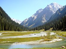
The Tian Shan holds important forests of Schrenk’s Spruce (Picea schrenkiana) at altitudes of over 2,000 metres (6,600 ft); the lower slopes have unique natural forests of wild walnuts and apples.[16]
The Tian Shan in its immediate geological past was kept from glaciation due to the «protecting» warm influence of the Indian Ocean monsoon climate. This defined its ecological features which could sustain its distinctive ecosphere. The mountains were subjected to constant geological changes with constantly evolving drainage systems which affected the patterns of vegetation, as well as exposing fertile soil for newly emerging seedlings to thrive in.
Tulips originated in Tian Shan Mountains. The plant then made its way to Turkey via the Silk Road and became a symbol of the Ottoman Empire.[17]
Ancestors of important crop vegetation were established and thrived in the area, among them: apricots (Prunus armeniaca), pears (Pyrus spp.), pomegranates (Punica granatum), figs (Ficus), cherries (Prunus avium) and mulberries (Morus). The Tian Shan region also included important animals like bear, deer and wild boar, which helped to spread seeds and expand the ecological diversity.
Among the vegetation colonizing the Tian Shan came, likely via birds from the east, the ancestors of what we know as the «sweet» apple. The fruit
probably then looked like a tiny, long-stalked, bitter apple something like Malus baccata, the Siberian crab. The pips may have been carried in a bird’s crop or clotted onto feet or feathers.
What natural features of the unique Tian Shan might have contributed to this rigorous selection program? Time is, as we have seen, not a problem. The turnover of individual trees is likewise conducive to the rapid evolution of a tree species, as is the fact that sweet apples are now, at least for all practical purposes, self-incompatible—that is, they cannot pollinate themselves. Therefore each apple tree within the forest and even each pip, usually five, within each individual fruit will be different. There are many apples on a mature tree, so natural selection has a rich and diverse population upon which to work. Birds, of course, eat all manner of fruit. But most birds eat seeds—a dietary feature not conducive either to the selection or spread of a fruit tree. Sweet apples are often eviscerated by birds, but the seeds are frequently left in the empty shell of the pome. The reason is that apple (and pear and quince) seeds are rich in cyanoglycosides, which are highly repellent, particularly to birds… Moreover, the placenta of the apple fruit, the womb, contains inhibitory substances that prevent the germination of the apple seed in situ. This is a commonly observed phenomenon in fruits as Michael Evenari showed in 1949. So what then does, or did, distribute the original apple seed? The bear…
Climate[edit]
Tian Shan has a alpine climate (Köppen climate classification ETH).
| Climate data for Tian Shan (1981−2010 normals, extremes 1981−2010) | |||||||||||||
|---|---|---|---|---|---|---|---|---|---|---|---|---|---|
| Month | Jan | Feb | Mar | Apr | May | Jun | Jul | Aug | Sep | Oct | Nov | Dec | Year |
| Record high °C (°F) | 0.4 (32.7) |
2.2 (36.0) |
8.5 (47.3) |
13.2 (55.8) |
15.5 (59.9) |
15.6 (60.1) |
19.2 (66.6) |
18.5 (65.3) |
16.4 (61.5) |
11.2 (52.2) |
6.5 (43.7) |
3.2 (37.8) |
19.2 (66.6) |
| Average high °C (°F) | −10.6 (12.9) |
−9.3 (15.3) |
−5.0 (23.0) |
0.5 (32.9) |
4.7 (40.5) |
8.3 (46.9) |
10.3 (50.5) |
10.1 (50.2) |
6.4 (43.5) |
0.4 (32.7) |
−5.0 (23.0) |
−8.7 (16.3) |
0.2 (32.3) |
| Daily mean °C (°F) | −15.1 (4.8) |
−14.1 (6.6) |
−10.3 (13.5) |
−5.0 (23.0) |
−0.5 (31.1) |
3.3 (37.9) |
5.3 (41.5) |
4.8 (40.6) |
1.1 (34.0) |
−4.6 (23.7) |
−9.7 (14.5) |
−13.2 (8.2) |
−4.8 (23.3) |
| Average low °C (°F) | −19.0 (−2.2) |
−18.1 (−0.6) |
−14.6 (5.7) |
−9.1 (15.6) |
−4.4 (24.1) |
−0.5 (31.1) |
1.7 (35.1) |
1.1 (34.0) |
−2.7 (27.1) |
−8.3 (17.1) |
−13.4 (7.9) |
−17.1 (1.2) |
−8.7 (16.3) |
| Record low °C (°F) | −39.7 (−39.5) |
−34.7 (−30.5) |
−31.2 (−24.2) |
−24.6 (−12.3) |
−18.8 (−1.8) |
−12.9 (8.8) |
−6.9 (19.6) |
−14.4 (6.1) |
−17.5 (0.5) |
−21.8 (−7.2) |
−36.4 (−33.5) |
−35.5 (−31.9) |
−39.7 (−39.5) |
| Average precipitation mm (inches) | 2.8 (0.11) |
4.4 (0.17) |
9.2 (0.36) |
25.3 (1.00) |
51.6 (2.03) |
97.2 (3.83) |
128.4 (5.06) |
92.6 (3.65) |
44.7 (1.76) |
13.3 (0.52) |
4.6 (0.18) |
2.9 (0.11) |
477 (18.78) |
| Average relative humidity (%) | 49 | 51 | 53 | 57 | 63 | 68 | 71 | 66 | 61 | 54 | 49 | 48 | 58 |
| Source: China Meteorological Data Service Center[19] |
Religion[edit]
Tengrism[edit]
In Tengrism, Khan Tengri is the lord of all spirits and the religion’s supreme deity, and it is the name given to the second highest peak of Tian Shan.[7]
See also[edit]
- Tectonics of the Tian Shan
- Pyotr Semyonov-Tyan-Shansky
Notes[edit]
- ^
- Chinese: 天山; pinyin: Tiānshān; lit. ‘Heaven Mountain’
- Dungan: Тянсан, Tiansan
- Old Turkic: 𐰴𐰣 𐱅𐰭𐰼𐰃, Tenğri tağ
- Turkish: Tanrı Dağı
- Mongolian: Тэнгэр уул, Tenger uul
- Uighur: تەڭرىتاغ, Tengri tagh, Тәңри тағ
- Kazakh: Тәңіртауы / Алатау, Táńirtaýy / Alataý, تٵڭٸرتاۋى / الاتاۋ
- Kyrgyz: Теңир-Тоо / Ала-Тоо, Tengir-Ta / Ala-Too, تەڭىر-توو / الا-توو
- Uzbek: Tyan-Shan / Tangritog‘, Тян-Шан / Тангритоғ, تيەن-شەن / تەڭرىتاغ
References[edit]
Citations[edit]
- ^ a b Prichard, James (1844). History of the Asiatic Nations. Vol. IV (3rd ed.). p. 281.
- ^ «Ensemble Tengir-Too». Aga Khan Trust for Culture. Archived from the original on 5 July 2019. Retrieved 5 July 2019.
- ^ a b c Scheffel, Richard L.; Wernet, Susan J., eds. (1980). Natural Wonders of the World. USA: Reader’s Digest Association, Inc. p. 378. ISBN 978-0-89577-087-5.
- ^ 班固 (2015-08-20). 漢書: 顏師古註 Hanshu: Yan Shigu Commentary. Archived from the original on 2023-01-14. Retrieved 2016-09-10.
祁連山即天山也,匈奴呼天為祁連 (translation: Qilian Mountain is the Tian Shan, the Xiongnu called the sky qilian)
- ^ Liu, Xinru (Fall 2001), «Migration and Settlement of the Yuezhi-Kushan: Interaction and Interdependence of Nomadic and Sedentary Societies», Journal of World History, 12 (2): 261–291, doi:10.1353/jwh.2001.0034, S2CID 162211306
- ^ Mallory, J. P. & Mair, Victor H. (2000). The Tarim Mummies: Ancient China and the Mystery of the Earliest Peoples from the West. London: Thames & Hudson. p. 58. ISBN 978-0-500-05101-6.
- ^ a b Wilkinson, Philip (2 October 2003). Myths and Legends. Stacey International. p. 163. ISBN 978-1900988612. Archived from the original on 14 January 2023. Retrieved 11 September 2016.
- ^ «新疆天山成功申遗». Archived from the original on 2013-06-27. Retrieved 2013-06-22.
- ^ «Western Tien-Shan». UNESCO World Heritage Centre. United Nations Educational, Scientific and Cultural Organization. Archived from the original on 7 July 2018. Retrieved 17 July 2016.
- ^ Gorbunov, A.P. (1993), «Geocryology in Mt. Tianshan», PERMAFROST: Sixth International Conference. Proceedings. July 5–9, Beijing, China, vol. 2, South China University of Technology Press, pp. 1105–1107, ISBN 978-7-5623-0484-5
- ^ Naik, Gautam (August 17, 2015). «Central Asia Mountain Range Has Lost a Quarter of Ice Mass in 50 Years, Study Says». Wall Street Journal. Archived from the original on August 18, 2015. Retrieved August 18, 2015.
- ^ a b c Kuhle, M. (1994). «New Findings on the Ice-cover between Issyk-Kul and K2 (Tian Shan, Karakorum) during the Last Glaciation». In Zheng Du; Zhang Qingsong; Pan Yusheng (eds.). Proceedings of the International Symposium on the Karakorum and Kunlun Mountains (ISKKM), Kashi, China, June 1992. Beijing: China Meteorological Press. pp. 185–197. ISBN 7-5029-1800-0.
- ^ Grosswald, M. G.; Kuhle, M.; Fastook, J. L. (1994). «Würm Glaciation of Lake Issyk-Kul Area, Tian Shan Mts.: A Case Study in Glacial History of Central Asia». GeoJournal. 33 (2/3): 273–310. doi:10.1007/BF00812878. S2CID 140639502.
- ^ a b Kuhle, M. (2004). «The High Glacial (Last Ice Age and LGM) glacier cover in High- and Central Asia. Accompanying text to the mapwork in hand with detailed references to the literature of the underlying empirical investigations». In Ehlers, J.; Gibbard, P. L. (eds.). Quaternary Glaciations — Extent and Chronology. Vol. 3. Amsterdam: Elsevier. pp. 175–199. ISBN 0-444-51462-7.
- ^ Kuhle, M.; Schröder, N. (2000). «New Investigations and Results on the Maximum Glaciation of the Kirgisen Shan and Tian Shan Plateau between Kokshaal Tau and Terskey Alatau». In Zech, W. (ed.). Pamir and Tian Shan. Contribution of the Quaternary History. International Workshop at the University of Bayreuth. Bayreuth, University Bayreuth. p. 8.
- ^ Janik, Erika (October 25, 2011). «How the apple took over the planet». Salon. Archived from the original on August 9, 2020. Retrieved March 15, 2020.
- ^ Great Courses: ‘The Botanist’s Eye'(DVD 2 chapter 7) by Catherine Kleier, PhD from California Polytechnic State University.
- ^ Juniper, Barrie E. (2007). «The Mysterious Origin of the Sweet Apple: On its way to a grocery counter near you, this delicious fruit traversed continents and mastered coevolution». American Scientist. 95 (1): 44–51. doi:10.1511/2007.63.44. JSTOR 27858899.
- ^ 中国地面气候标准值月值(1981-2010) (in Chinese (China)). China Meteorological Data Service Center. Archived from the original on September 5, 2018. Retrieved December 15, 2022.
Sources[edit]
- The Contemporary Atlas of China. 1988. London: Marshall Editions Ltd. Reprint 1989. Sydney, NSW: Collins Publishers Australia.
- The Times Comprehensive Atlas of the World. Eleventh Edition. 2003. London, England: Times Books Group Ltd.
External links[edit]
![]()
Wikimedia Commons has media related to Tian Shan.
- Russian mountaineering site
- Tien Shan
- Bealby, John Thomas (1911). «Tian-shan» . Encyclopædia Britannica. Vol. 26 (11th ed.). pp. 909–911.
- United Nations University (2009) digital video «Finding a place to feed: Kyrgyz shepherds & pasture loss»: Shepherd shares family’s observations and adaptation to the changing climate in highland pastures of Kyrgyzstan’s Tian Shan mountains Accessed 1 December 2009
From Wikipedia, the free encyclopedia
| Tian Shan 天山 | |
|---|---|
| Tengri Tagh, Tengir-Too | |
|
The Tian Shan range on the border between China, Kazakhstan and Kyrgyzstan with Khan Tengri (7,010 m) visible at center |
|
| Highest point | |
| Peak | Jengish Chokusu |
| Elevation | 7,439 m (24,406 ft) |
| Coordinates | 42°02′06″N 80°07′32″E / 42.03500°N 80.12556°E |
| Geography | |
|
|
|
| Countries | China, Kazakhstan, Kyrgyzstan, Uzbekistan and Tajikistan |
| Range coordinates | 42°N 80°E / 42°N 80°ECoordinates: 42°N 80°E / 42°N 80°E |
| Geology | |
| Age of rock | Mesozoic and Cenozoic |
|
UNESCO World Heritage Site |
|
| Official name | Xinjiang Tianshan |
| Type | Natural |
| Criteria | vii, ix |
| Designated | 2013 (37th session) |
| Reference no. | 1414 |
| Region | Asia |
|
UNESCO World Heritage Site |
|
| Official name | Western Tien-Shan |
| Type | Natural |
| Criteria | x |
| Designated | 2016 (40th session) |
| Reference no. | 1490 |
| Region | Asia |
The Tian Shan,[note 1] also known as the Tengri Tagh[1] or Tengir-Too,[2] meaning the Mountains of Heaven or the Heavenly Mountain, is a large system of mountain ranges in Central Asia. The highest peak in the Tian Shan is Jengish Chokusu, at 7,439 metres (24,406 ft) high. Its lowest point is the Turpan Depression, which is 154 m (505 ft) below sea level.[3]
One of the earliest historical references to these mountains may be related to the Xiongnu word Qilian (traditional Chinese: 祁連; simplified Chinese: 祁连; pinyin: Qílián) – according to Tang commentator Yan Shigu, Qilian is the Xiongnu word for sky or heaven.[4] Sima Qian in the Records of the Grand Historian mentioned Qilian in relation to the homeland of the Yuezhi and the term is believed to refer to the Tian Shan rather than the Qilian Mountains 1,500 kilometres (930 mi) further east now known by this name.[5][6] The Tannu-Ola mountains in Tuva has the same meaning in its name («heaven/celestial mountains» or «god/spirit mountains»). The name in Chinese, Tian Shan, is most likely a direct translation of the traditional Kyrgyz name for the mountains, Teñir Too.[1] The Tian Shan is sacred in Tengrism, and its second-highest peak is known as Khan Tengri which may be translated as «Lord of the Spirits».[7] At the 2013 Conference on World Heritage, the eastern portion of Tian Shan in western China’s Xinjiang Region was listed as a World Heritage Site.[8] The western portion in Kazakhstan, Kyrgyzstan, and Uzbekistan was then listed in 2016.[9]
Geography[edit]
Tian Shan is north and west of the Taklamakan Desert and directly north of the Tarim Basin in the border region of Kazakhstan, Kyrgyzstan, Uzbekistan and Xinjiang in Northwest China. In the south it links up with the Pamir Mountains and to north and east it meets the Altai Mountains of Mongolia.
In Western cartography as noted by the National Geographic Society, the eastern end of the Tian Shan is usually understood to be east of Ürümqi, with the range to the east of that city known as the Bogda Shan as part of the Tian Shan. Chinese cartography from the Han Dynasty to the present agrees, with the Tian Shan including the Bogda Shan and Barkol ranges.
Tian Shan Mountains from space, October 1997, with Issyk-Kul Lake in Kyrgyzstan at the northern end
The Tian Shan are a part of the Himalayan orogenic belt, which was formed by the collision of the Indian and Eurasian plates in the Cenozoic era. They are one of the longest mountain ranges in Central Asia and stretch some 2,900 kilometres (1,800 mi) eastward from Tashkent in Uzbekistan.[3]
The highest peak in the Tian Shan is Jengish Chokusu (also called Victory Peak) on the border of China. At 7,439 metres (24,406 ft) high, it is the highest point in Kyrgyzstan.[3] The Tian Shan’s second highest peak, Khan Tengri (King Heaven), straddles the Kazakhstan-Kyrgyzstan-China tripoint and at 7,010 metres (23,000 ft) is the highest point of Kazakhstan. Mountaineers class these as the two most northerly peaks over 7,000 metres (23,000 ft) in the world.
The Torugart Pass, at 3,752 metres (12,310 ft), is located at the border between Kyrgyzstan and China’s Xinjiang province. The forested Alatau ranges, which are at a lower altitude in the northern part of the Tian Shan, are inhabited by pastoral tribes that speak Turkic languages.
The Tian Shan are separated from the Tibetan Plateau by the Taklimakan Desert and the Tarim Basin to the south.
The major rivers rising in the Tian Shan are the Syr Darya, the Ili River and the Tarim River. The Aksu Canyon is a notable feature in the northwestern Tian Shan.
Continuous permafrost is typically found in the Tian Shan starting at the elevation of about 3,500-3,700 m above the sea level. Discontinuous alpine permafrost usually occurs down to 2,700-3,300 m, but in certain locations, due to the peculiarity of the aspect and the microclimate, it can be found at elevations as low as 2,000 m.[10]
One of the first Europeans to visit and the first to describe the Tian Shan in detail was the Russian explorer Peter Semenov, who did so in the 1850s.
Glaciers in the Tian Shan Mountains have been rapidly shrinking and have lost 27%, or 5.4 billion tons annually, of its ice mass since 1961 compared to an average of 7% worldwide.[11] It is estimated that by 2050 half of the remaining glaciers will have melted.
Ranges[edit]
The Tian Shan have a number of named ranges which are often mentioned separately (all distances are approximate).
In China the Tian Shan starts north of Kumul City (Hami) with the U-shaped Barkol Mountains, from about 600 to 400 kilometres (370 to 250 mi) east of Ürümqi. Then the Bogda Shan (god mountains) run from 350 to 40 kilometres (217 to 25 mi) east of Ürümqi. Then there is a low area between Ürümqi and the Turfan Depression. The Borohoro Mountains start just south of Ürümqi and run west-northwest 450 kilometres (280 mi) separating Dzungaria from the Ili River basin. Their north end abuts on the 200 kilometres (120 mi) Dzungarian Alatau which runs east northeast along Sino-Kazakh border. They start 50 kilometres (31 mi) east of Taldykorgan in Kazakhstan and end at the Dzungarian Gate. The Dzungarian Alatau in the north, the Borohoro Mountains in the middle and the Ketmen Ridge in the south make a reversed Z or S, the northeast enclosing part of Dzungaria and the southwest enclosing the upper Ili valley.
Map of Kyrgyzstan (borders marked in red). The Tian Shan makes up large parts of southern Kyrgyzstan. The indentation on the west is the Fergana Valley
In Kyrgyzstan the mainline of the Tian Shan continues as Narat Range from the base of the Borohoros west 570 kilometres (350 mi) to the point where China, Kazakhstan, and Kyrgyzstan meet. Here is the highest part of the range – the Central Tian Shan, with Peak Pobeda (Kakshaal Too range) and Khan Tengri. West of this, the Tian Shan split into an ‘eye’, with Issyk Kul Lake in its center. The south side of the lake is the Terskey Alatau and the north side the Kyungey Ala-Too (shady and sunny Ala-Too). North of the Kyungey Ala-Too and parallel to it is the Trans-Ili Alatau in Kazakhstan just south of Almaty. West of the eye, the range continues 400 kilometres (250 mi) as the Kyrgyz Ala-Too, separating Chüy Region from Naryn Region and then Kazakhstan from the upper valley of the river Talas, the south side of which is the 200 kilometres (120 mi) Talas Ala-Too Range (‘Ala-too’ is a Kyrgyz spelling of Alatau). At the east end of the Talas Alatau the Suusamyr Too range runs southeast enclosing the Suusamyr Valley or plateau.
As for the area south of the Fergana Valley there is an 800 kilometres (500 mi) group of mountains that curves west-southwest from south of Issyk Kul Lake separating the Tarim Basin from the Fergana Valley. The Fergana Range runs northeast towards the Talas Ala-Too and separates the upper Naryn basin from Fergana proper. The southern side of these mountains merge into the Pamirs in Tajikistan (Alay Mountains and Trans-Alay Range). West of this is the Turkestan Range, which continues almost to Samarkand.
Ice Age[edit]
On the north margin of the Tarim basin between the mountain chain of the Kokshaal-Tau in the south and that one of the Terskey Alatau in the north there stretches the 100 to 120 km (62 to 75 mi) wide Tian Shan plateau with its set up mountain landscape. The Kokshaal-Tau continues with an overall length of 570 km (350 mi) from W of Pik Dankowa (Dankov, 5986 m) up to east-north-east to Pik Pobeda (Tumor Feng, 7439 m) and beyond it. This mountain chain as well as that of the 300 km long parallel mountain chain of the Terskey Alatau and the Tian Shan plateau situated in between, during glacial times were covered by connected ice-stream-networks and a plateau glacier. Currently, the interglacial remnant of this glaciation is formed by the only just 61 km long South Inylschek glacier. The outlet glacier tongues of the plateau glacier flowed to the north as far as down to Lake Issyk Kul (Lake) at 1605 (1609) m asl calving in this 160 km long lake.
In the same way, strong glaciation was in excess of 50 km wide in the high mountain area of the Kungey Alatau, connecting north of Issyk Kul and stretching as far as the mountain foreland near Alma Ata. The Kungey Alatau is 230 km long. Down from the Kungey Alatau the glacial glaciers also calved into the Issyk Kul lake. The Chon-Kemin valley was glaciated up to its inflow into the Chu valley.[12][13][14] From the west-elongation of the Kungey Alatau—that is the Kirgizskiy Alatau range (42°25′N/74–75°E)—the glacial glaciers flowed down as far as into the mountain foreland down to 900 m asl (close to the town Bishkek). Among others the Ak-Sai valley glacier has developed there a mountain foreland glacier.[12][15][14]
Altogether the glacial Tian Shan glaciation occupied an area of c. 118,000 square kilometres (46,000 sq mi). The glacier snowline (ELA) between the glacier feeding area and melting zone was about 1200m lower during the last ice age than it is today.
Under the condition of a comparable precipitation ratio, there would result from this a depression of the average annual temperature of 7.2 to 8.4 °C for the Last Glacial Maximum compared with today.[12]
Ecology[edit]
The Tian Shan holds important forests of Schrenk’s Spruce (Picea schrenkiana) at altitudes of over 2,000 metres (6,600 ft); the lower slopes have unique natural forests of wild walnuts and apples.[16]
The Tian Shan in its immediate geological past was kept from glaciation due to the «protecting» warm influence of the Indian Ocean monsoon climate. This defined its ecological features which could sustain its distinctive ecosphere. The mountains were subjected to constant geological changes with constantly evolving drainage systems which affected the patterns of vegetation, as well as exposing fertile soil for newly emerging seedlings to thrive in.
Tulips originated in Tian Shan Mountains. The plant then made its way to Turkey via the Silk Road and became a symbol of the Ottoman Empire.[17]
Ancestors of important crop vegetation were established and thrived in the area, among them: apricots (Prunus armeniaca), pears (Pyrus spp.), pomegranates (Punica granatum), figs (Ficus), cherries (Prunus avium) and mulberries (Morus). The Tian Shan region also included important animals like bear, deer and wild boar, which helped to spread seeds and expand the ecological diversity.
Among the vegetation colonizing the Tian Shan came, likely via birds from the east, the ancestors of what we know as the «sweet» apple. The fruit
probably then looked like a tiny, long-stalked, bitter apple something like Malus baccata, the Siberian crab. The pips may have been carried in a bird’s crop or clotted onto feet or feathers.
What natural features of the unique Tian Shan might have contributed to this rigorous selection program? Time is, as we have seen, not a problem. The turnover of individual trees is likewise conducive to the rapid evolution of a tree species, as is the fact that sweet apples are now, at least for all practical purposes, self-incompatible—that is, they cannot pollinate themselves. Therefore each apple tree within the forest and even each pip, usually five, within each individual fruit will be different. There are many apples on a mature tree, so natural selection has a rich and diverse population upon which to work. Birds, of course, eat all manner of fruit. But most birds eat seeds—a dietary feature not conducive either to the selection or spread of a fruit tree. Sweet apples are often eviscerated by birds, but the seeds are frequently left in the empty shell of the pome. The reason is that apple (and pear and quince) seeds are rich in cyanoglycosides, which are highly repellent, particularly to birds… Moreover, the placenta of the apple fruit, the womb, contains inhibitory substances that prevent the germination of the apple seed in situ. This is a commonly observed phenomenon in fruits as Michael Evenari showed in 1949. So what then does, or did, distribute the original apple seed? The bear…
Climate[edit]
Tian Shan has a alpine climate (Köppen climate classification ETH).
| Climate data for Tian Shan (1981−2010 normals, extremes 1981−2010) | |||||||||||||
|---|---|---|---|---|---|---|---|---|---|---|---|---|---|
| Month | Jan | Feb | Mar | Apr | May | Jun | Jul | Aug | Sep | Oct | Nov | Dec | Year |
| Record high °C (°F) | 0.4 (32.7) |
2.2 (36.0) |
8.5 (47.3) |
13.2 (55.8) |
15.5 (59.9) |
15.6 (60.1) |
19.2 (66.6) |
18.5 (65.3) |
16.4 (61.5) |
11.2 (52.2) |
6.5 (43.7) |
3.2 (37.8) |
19.2 (66.6) |
| Average high °C (°F) | −10.6 (12.9) |
−9.3 (15.3) |
−5.0 (23.0) |
0.5 (32.9) |
4.7 (40.5) |
8.3 (46.9) |
10.3 (50.5) |
10.1 (50.2) |
6.4 (43.5) |
0.4 (32.7) |
−5.0 (23.0) |
−8.7 (16.3) |
0.2 (32.3) |
| Daily mean °C (°F) | −15.1 (4.8) |
−14.1 (6.6) |
−10.3 (13.5) |
−5.0 (23.0) |
−0.5 (31.1) |
3.3 (37.9) |
5.3 (41.5) |
4.8 (40.6) |
1.1 (34.0) |
−4.6 (23.7) |
−9.7 (14.5) |
−13.2 (8.2) |
−4.8 (23.3) |
| Average low °C (°F) | −19.0 (−2.2) |
−18.1 (−0.6) |
−14.6 (5.7) |
−9.1 (15.6) |
−4.4 (24.1) |
−0.5 (31.1) |
1.7 (35.1) |
1.1 (34.0) |
−2.7 (27.1) |
−8.3 (17.1) |
−13.4 (7.9) |
−17.1 (1.2) |
−8.7 (16.3) |
| Record low °C (°F) | −39.7 (−39.5) |
−34.7 (−30.5) |
−31.2 (−24.2) |
−24.6 (−12.3) |
−18.8 (−1.8) |
−12.9 (8.8) |
−6.9 (19.6) |
−14.4 (6.1) |
−17.5 (0.5) |
−21.8 (−7.2) |
−36.4 (−33.5) |
−35.5 (−31.9) |
−39.7 (−39.5) |
| Average precipitation mm (inches) | 2.8 (0.11) |
4.4 (0.17) |
9.2 (0.36) |
25.3 (1.00) |
51.6 (2.03) |
97.2 (3.83) |
128.4 (5.06) |
92.6 (3.65) |
44.7 (1.76) |
13.3 (0.52) |
4.6 (0.18) |
2.9 (0.11) |
477 (18.78) |
| Average relative humidity (%) | 49 | 51 | 53 | 57 | 63 | 68 | 71 | 66 | 61 | 54 | 49 | 48 | 58 |
| Source: China Meteorological Data Service Center[19] |
Religion[edit]
Tengrism[edit]
In Tengrism, Khan Tengri is the lord of all spirits and the religion’s supreme deity, and it is the name given to the second highest peak of Tian Shan.[7]
See also[edit]
- Tectonics of the Tian Shan
- Pyotr Semyonov-Tyan-Shansky
Notes[edit]
- ^
- Chinese: 天山; pinyin: Tiānshān; lit. ‘Heaven Mountain’
- Dungan: Тянсан, Tiansan
- Old Turkic: 𐰴𐰣 𐱅𐰭𐰼𐰃, Tenğri tağ
- Turkish: Tanrı Dağı
- Mongolian: Тэнгэр уул, Tenger uul
- Uighur: تەڭرىتاغ, Tengri tagh, Тәңри тағ
- Kazakh: Тәңіртауы / Алатау, Táńirtaýy / Alataý, تٵڭٸرتاۋى / الاتاۋ
- Kyrgyz: Теңир-Тоо / Ала-Тоо, Tengir-Ta / Ala-Too, تەڭىر-توو / الا-توو
- Uzbek: Tyan-Shan / Tangritog‘, Тян-Шан / Тангритоғ, تيەن-شەن / تەڭرىتاغ
References[edit]
Citations[edit]
- ^ a b Prichard, James (1844). History of the Asiatic Nations. Vol. IV (3rd ed.). p. 281.
- ^ «Ensemble Tengir-Too». Aga Khan Trust for Culture. Archived from the original on 5 July 2019. Retrieved 5 July 2019.
- ^ a b c Scheffel, Richard L.; Wernet, Susan J., eds. (1980). Natural Wonders of the World. USA: Reader’s Digest Association, Inc. p. 378. ISBN 978-0-89577-087-5.
- ^ 班固 (2015-08-20). 漢書: 顏師古註 Hanshu: Yan Shigu Commentary. Archived from the original on 2023-01-14. Retrieved 2016-09-10.
祁連山即天山也,匈奴呼天為祁連 (translation: Qilian Mountain is the Tian Shan, the Xiongnu called the sky qilian)
- ^ Liu, Xinru (Fall 2001), «Migration and Settlement of the Yuezhi-Kushan: Interaction and Interdependence of Nomadic and Sedentary Societies», Journal of World History, 12 (2): 261–291, doi:10.1353/jwh.2001.0034, S2CID 162211306
- ^ Mallory, J. P. & Mair, Victor H. (2000). The Tarim Mummies: Ancient China and the Mystery of the Earliest Peoples from the West. London: Thames & Hudson. p. 58. ISBN 978-0-500-05101-6.
- ^ a b Wilkinson, Philip (2 October 2003). Myths and Legends. Stacey International. p. 163. ISBN 978-1900988612. Archived from the original on 14 January 2023. Retrieved 11 September 2016.
- ^ «新疆天山成功申遗». Archived from the original on 2013-06-27. Retrieved 2013-06-22.
- ^ «Western Tien-Shan». UNESCO World Heritage Centre. United Nations Educational, Scientific and Cultural Organization. Archived from the original on 7 July 2018. Retrieved 17 July 2016.
- ^ Gorbunov, A.P. (1993), «Geocryology in Mt. Tianshan», PERMAFROST: Sixth International Conference. Proceedings. July 5–9, Beijing, China, vol. 2, South China University of Technology Press, pp. 1105–1107, ISBN 978-7-5623-0484-5
- ^ Naik, Gautam (August 17, 2015). «Central Asia Mountain Range Has Lost a Quarter of Ice Mass in 50 Years, Study Says». Wall Street Journal. Archived from the original on August 18, 2015. Retrieved August 18, 2015.
- ^ a b c Kuhle, M. (1994). «New Findings on the Ice-cover between Issyk-Kul and K2 (Tian Shan, Karakorum) during the Last Glaciation». In Zheng Du; Zhang Qingsong; Pan Yusheng (eds.). Proceedings of the International Symposium on the Karakorum and Kunlun Mountains (ISKKM), Kashi, China, June 1992. Beijing: China Meteorological Press. pp. 185–197. ISBN 7-5029-1800-0.
- ^ Grosswald, M. G.; Kuhle, M.; Fastook, J. L. (1994). «Würm Glaciation of Lake Issyk-Kul Area, Tian Shan Mts.: A Case Study in Glacial History of Central Asia». GeoJournal. 33 (2/3): 273–310. doi:10.1007/BF00812878. S2CID 140639502.
- ^ a b Kuhle, M. (2004). «The High Glacial (Last Ice Age and LGM) glacier cover in High- and Central Asia. Accompanying text to the mapwork in hand with detailed references to the literature of the underlying empirical investigations». In Ehlers, J.; Gibbard, P. L. (eds.). Quaternary Glaciations — Extent and Chronology. Vol. 3. Amsterdam: Elsevier. pp. 175–199. ISBN 0-444-51462-7.
- ^ Kuhle, M.; Schröder, N. (2000). «New Investigations and Results on the Maximum Glaciation of the Kirgisen Shan and Tian Shan Plateau between Kokshaal Tau and Terskey Alatau». In Zech, W. (ed.). Pamir and Tian Shan. Contribution of the Quaternary History. International Workshop at the University of Bayreuth. Bayreuth, University Bayreuth. p. 8.
- ^ Janik, Erika (October 25, 2011). «How the apple took over the planet». Salon. Archived from the original on August 9, 2020. Retrieved March 15, 2020.
- ^ Great Courses: ‘The Botanist’s Eye'(DVD 2 chapter 7) by Catherine Kleier, PhD from California Polytechnic State University.
- ^ Juniper, Barrie E. (2007). «The Mysterious Origin of the Sweet Apple: On its way to a grocery counter near you, this delicious fruit traversed continents and mastered coevolution». American Scientist. 95 (1): 44–51. doi:10.1511/2007.63.44. JSTOR 27858899.
- ^ 中国地面气候标准值月值(1981-2010) (in Chinese (China)). China Meteorological Data Service Center. Archived from the original on September 5, 2018. Retrieved December 15, 2022.
Sources[edit]
- The Contemporary Atlas of China. 1988. London: Marshall Editions Ltd. Reprint 1989. Sydney, NSW: Collins Publishers Australia.
- The Times Comprehensive Atlas of the World. Eleventh Edition. 2003. London, England: Times Books Group Ltd.
External links[edit]
![]()
Wikimedia Commons has media related to Tian Shan.
- Russian mountaineering site
- Tien Shan
- Bealby, John Thomas (1911). «Tian-shan» . Encyclopædia Britannica. Vol. 26 (11th ed.). pp. 909–911.
- United Nations University (2009) digital video «Finding a place to feed: Kyrgyz shepherds & pasture loss»: Shepherd shares family’s observations and adaptation to the changing climate in highland pastures of Kyrgyzstan’s Tian Shan mountains Accessed 1 December 2009
| Тянь-Шань | |
 |
|
| Пик Хан-Тенгри на закате | |
| Координаты: Координаты: 42°02′00″ с. ш. 80°08′00″ в. д. / 42.033333° с. ш. 80.133333° в. д. (G) (O) (Я)42°02′00″ с. ш. 80°08′00″ в. д. / 42.033333° с. ш. 80.133333° в. д. (G) (O) (Я) (T) | |
| Страны | |
|
Тянь-Шань |
|
Тянь-Ша́нь (кит. трад. 天山山脈, упр. 天山山脉, пиньинь: Tiānshān shānmài, уйг. تەڭرىتاغ, Тәңри тағ, каз. Тәңір шыңы, Тәңір тау, узб. Tyan Shan, кирг. Теңир тоо) — горная система, расположенная в Центральной Азии на границе между Казахстаном, Узбекистаном, Киргизией и Синьцзян-Уйгурским автономным районом Китая.
Содержание
- 1 Происхождение названия
- 2 Географическое описание
- 3 Исследования Тянь-Шаня
- 4 См. также
- 5 Примечания
- 6 Ссылки
Происхождение названия
Название Тянь-Шань по-китайски (天山) означает «небесные горы». Тюркское название, от которого произошло китайское — Тәңір (Тәңир, Тәңри, Тенгри, Тенир, Тенгир, Аспан)- тау.
Географическое описание
В систему Тянь-Шаня входит более тридцати вершин высотой более 6000 метров. Самой высокой точкой горной системы является пик Победы (Томур, 7439 м), расположенный на границе Киргизии и Синьцзян-Уйгурского автономного района Китая; следующая по высоте — пик Хан-Тенгри (Кантау, 7010 м) на границе Киргизии и Казахстана[1].
От Центрального Тянь-Шаня к западу расходятся три горные цепи, разделенные межгорными котловинами (Иссык-Кульская с озером Иссык-Куль, Нарынская, Ат-Башынская и др.) и соединенные на западе Ферганским хребтом.
В Восточном Тянь-Шане две параллельные горные цепи (высота 4-5 тыс. м.), разделенные впадинами (высота 2-3 тыс. м). Характерны высокоподнятые (3-4 тыс. м) выровненные поверхности — сырты. Общая площадь ледников — 7,3 тыс. км², наиболее крупный Южный Иныльчек. Порожистые реки — Нарын, Чу, Или и др. Господствуют горные степи и полупустыни: на северных склонах лугостепи и леса (главным образом хвойные), выше субальпийские и альпийские луга, на сыртах так называемые холодные пустыни.
Протяжённость Тянь-Шаня с запада на восток составляет 2500 км.горная система в Ср.. и Центр. Азии. Длина с 3. на В. 2500 км, высшая точка — пик Победы. Альпийская складчатость, остатки древних выровненных поверхностей сохранились на высоте 3000—4000 м в виде сыртов. Высока современная тектоническая активность, часты землетрясения. Горные хребты сложены магматическими, котловины — осадочными породами. Месторождения ртути, сурьмы, свинца, кадмия, цинка, серебра, в котловинах — нефть. Рельеф преимущественно высокогорный, с ледниковыми формами, осыпями, выше 3200 м распространена многолетняя мерзлота. Есть плоские межгорные котловины (Ферганская, Иссык-Кульская, Нарынская). Климат континентальный, умеренный. Снежники и ледники. Реки относятся к бассейнам внутреннего стока (Нарын, Или, Чу, Тарим и др.), оз. Иссык-Куль. Сонг-Кель, Чатыр-Кель.
Краткий географический словарь. EdwART. 2008.
Исследования Тянь-Шаня
Первым европейским исследователем Тянь-Шаня в 1856 году стал Пётр Петрович Семёнов, получивший за свой труд титул «Семёнов-Тян-Шанский».

![]()
Рельеф Тянь-Шаня
См. также
- Гобийский Тянь-Шань
- Иныльчектау
Примечания
- ↑ Было принято совместное заявление КНР, Казахстана и Кыргызстана что пик Хан-Тенгри рассматривается как принадлежащий вышеописанным государствам. До этого были споры о принадлежности пика той или иной стране. Однако, фактически пик находится в 12 километрах к западу от границы Синьцзян-Уйгурского автономного района Китая [1]
Ссылки
- Перевалы Тянь-Шаня
- Тянь-Шань в книге: Н. А. Гвоздецкий, Н. И. Михайлов. Физическая география СССР. М., 1978.
- Именем Путина назван пик в Тянь-Шане
|
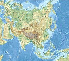
Горные системы Азии |
|
|---|---|
|
Алтай | Антиливан | Большой Кавказ | Бырранга | Восточный Саян | Гандисышань | Гималаи | Гиндукуш | Джугджур | Западный Саян | Имеон | Кавказ | Каракорум | Копетдаг | Куньлунь | Малый Кавказ | Памир | Сихотэ-Алинь | Становое нагорье | Тянь-Шань | Урал | Хамар-Дабан | Эльбурс |